
A Thessaloniki walking tour crosses more than two thousand years of history on foot, from the White Tower on the waterfront to the Roman Rotunda and the Arch of Galerius, the Byzantine churches on the UNESCO list, the lanes of the Upper Town and the city walls, with the Jewish and Ottoman past of the city along the way. This post covers what a Thessaloniki walking tour includes, each stop on the route, the museums, how to reach the city and the best season. It is one of the city walking tours in Greece on Greece VIP.
Each section ends with a Thessaloniki walking tour that can be booked online.
What does a Thessaloniki walking tour include?
A Thessaloniki walking tour links the public monuments of the historic centre. It follows Roman, Byzantine, Ottoman and modern layers, from sea-facing spaces to inland streets. Each stop shows a different phase of the urban story and the changing religious life of the city.
Thessaloniki was founded in 315 BC by Cassander of Macedon, who named it for his wife Thessalonike. The city became an important Roman metropolis and later the second largest and wealthiest city of the Byzantine Empire. Ottoman rule began in 1430, and Thessaloniki entered the Kingdom of Greece in 1912. A Thessaloniki walking tour places these periods beside each other through surviving streets, churches, fortifications and civic spaces.
The route can move from the Thermaic Gulf into the central grid, where Roman structures stand near Byzantine churches and Ottoman-era works. A Thessaloniki walking tour gives context before attention turns to stone, brick, mosaics, inscriptions and street layouts. Each stop offers a different record of power, belief, trade or daily life. The sequence makes the layered past easier to follow than isolated sights.
Thessaloniki served as a provincial capital and sea port, and UNESCO describes it as an early base for the spread of Christianity. Its Christian monuments span the fourth to the fifteenth century and include central-plan churches, basilicas and transitional forms. A Thessaloniki walking tour connects this range with Roman public spaces and later Ottoman alterations. The port, the main square and the churches sit close together in this central zone. For a separate local-food focus, see this Thessaloniki food experience.
- Historical frame: A Thessaloniki walking tour traces the city from its Macedonian foundation through Roman, Byzantine, Ottoman and Greek periods.
- Monument focus: The walk brings Roman structures, churches, squares, the waterfront and the Upper Town into one route.
- Built evidence: Stone walls, marble reliefs, brick churches and mosaics show distinct phases of urban life.
- City setting: The Thermaic Gulf places the historic centre on the northwest edge of the Aegean Sea.
A Thessaloniki walking tour works best as a connected reading of the city. Foundation, empire, faith and port life sit within a compact central area. Roman civic remains, Byzantine churches and Ottoman changes create a sequence that explains how Thessaloniki developed across more than two millennia. The stops make that long span easier to follow.


Where does a Thessaloniki walking tour start?
A Thessaloniki walking tour can start at Aristotelous Square, the main square of the city on the waterfront. Its broad opening towards the sea gives immediate orientation. The square also introduces the planned civic axis that links the seafront with inland monuments.
Aristotelous Square stands on Nikis Avenue at the waterfront in central Thessaloniki. French architect Ernest Hébrard designed it in 1918, and much of the square was built in the 1950s. It is dedicated to Aristotle, and its twelve surrounding buildings have been listed buildings of Greece since 1950. The square also serves as a setting for festivals, rallies and public celebrations. A Thessaloniki walking tour can use this open space as a first reference point.
Hébrard planned a monumental axis from the seafront square towards Dikastirion Square and the Roman Forum. He used Byzantine and Western elements, with façades intended to shape public views. Looking uphill from the square, the plan framed the Byzantine walls and the Upper Town. A Thessaloniki walking tour follows part of this relationship between shore, centre and higher ground.
The design followed the Great Fire of 1917, which destroyed two thirds of Thessaloniki. It replaced an older fabric of narrow streets with a formal civic space facing the water. A Thessaloniki walking tour starts here because the square shows twentieth-century planning beside a much older city. The waterfront position also makes the direction of the Thermaic Gulf clear before the route turns inland.
- Starting point: Aristotelous Square is the main square of Thessaloniki and stands on the waterfront.
- Designer: Ernest Hébrard designed the square in 1918 as part of a wider plan for the city.
- Urban axis: The planned line runs from the seafront towards Dikastirion Square and the Roman Forum.
- Public setting: Listed buildings and an open sea-facing edge make the square a clear meeting place for a Thessaloniki walking tour.
A Thessaloniki walking tour beginning at Aristotelous Square starts with both geography and planning. The sea lies at one end, while the line towards the Roman Forum directs attention inland. That arrangement makes later stops easier to understand and shows how a twentieth-century square was inserted into a city with Roman and Byzantine foundations.
What does a Thessaloniki walking tour see at the White Tower?
A Thessaloniki walking tour sees the White Tower as a waterfront fortress, former garrison and former prison that now holds a history exhibition. Its six levels, circular form and upper platform explain its defensive purpose and connect the monument with Ottoman and modern chapters.
The present White Tower was built by the Ottomans after Sultan Murad II captured Thessaloniki in 1430. It replaced an older Byzantine fortification mentioned in the twelfth century and guarded the eastern end of the sea walls of the city. A Thessaloniki walking tour can read this position as part of the former coastal defence line of the city, although the wider walls no longer stand beside the tower.
During Ottoman rule the tower served as a fortress, garrison and prison. It gained the name Tower of Blood, or Kanlı Kule, after executions of imprisoned Janissaries there in 1826, and its present name dates from 1890, when a convict whitewashed the exterior in exchange for freedom. A Thessaloniki walking tour uses these names to explain changes in power and purpose.
The cylindrical tower rises 33.9 metres and has a diameter of 22.7 metres. A spiral ramp reaches outer-wall openings, while central rooms serve the six floors. The White Tower now contains an exhibition on the history of the city, organised by the Museum of Byzantine Culture under the Greek Ministry of Culture. A Thessaloniki walking tour can finish at the upper platform, where waterfront and city meet in one view. The White Tower has been adopted as the symbol of Thessaloniki.
- Construction: The Ottoman tower was built after the capture of Thessaloniki in 1430.
- Former names: Tower of Blood and Kanlı Kule recall its use as a prison and execution site.
- Form: The White Tower has six floors within a cylindrical structure 33.9 metres high.
- Present use: A Thessaloniki walking tour reaches a monument that now holds a history exhibition.
A Thessaloniki walking tour at the White Tower brings military architecture into the open waterfront landscape. Its role changed from defensive work to detention and then public interpretation. The form, position and exhibition show how one monument can carry Ottoman history and later Greek civic identity. It also helps in reading the line of the shore.
What does a Thessaloniki walking tour see on the waterfront?
A Thessaloniki walking tour sees the waterfront as a public edge beside the Thermaic Gulf. It joins the old promenade near the White Tower with the newer coastal park and the port. The city here is both a sea port and an urban centre.
The Thermaic Gulf forms the northwest corner of the Aegean Sea, with Thessaloniki at its northeastern tip. The gulf is also called the Gulf of Thessaloniki and the Macedonian Gulf, and it is about 100 kilometres long. This position shaped the city as a port from its foundation. A Thessaloniki walking tour along the shore keeps the water in view while linking public spaces with the centre and the port.
The newer waterfront, called Nea Paralia, runs for 3 kilometres along the coast from the White Tower to the Thessaloniki Concert Hall, and it contains twelve thematic gardens and parks. The older promenade continues beside Nikis Avenue and Aristotelous Square. A Thessaloniki walking tour shows that these spaces sit beside a working maritime setting rather than outside the historic city.
The Port of Thessaloniki is the main maritime gateway to Southeast, Central and Eastern Europe. It handles containers, conventional cargo and passenger traffic, and its free zone connects with rail services. It is also the largest and busiest port on the Thermaic Gulf. A Thessaloniki walking tour can observe this working setting from the waterfront while keeping attention on the public shore.
- Water body: The Thermaic Gulf is part of the Aegean Sea, and Thessaloniki lies at its northeastern tip.
- New promenade: Nea Paralia extends for 3 kilometres from the White Tower to the Thessaloniki Concert Hall.
- Public landscape: The newer waterfront includes twelve thematic gardens and parks along the coast.
- Harbour role: A Thessaloniki walking tour passes a shoreline near the largest and busiest port of the gulf.
On clear days, Mount Olympus can appear across the gulf from Thessaloniki, about 80 kilometres away. A Thessaloniki walking tour on the waterfront therefore combines close detail with a wider regional view. The sea edge explains why the city grew as a commercial centre, while the distant mountain gives scale to the horizon.
Why does a Thessaloniki walking tour stop at the Rotunda?
A Thessaloniki walking tour stops at the Rotunda because one circular monument records Roman imperial building, Christian worship and Ottoman use as a mosque. Galerius commissioned it around 306 AD, and it keeps early Christian mosaics and a surviving minaret.
The Rotunda of Galerius, also called the Rotunda of Saint George, stands 125 metres northeast of the Arch of Galerius. Galerius ordered the circular structure around 306 AD, and it was thought to be intended as his mausoleum. Its walls are more than 6 metres thick, and a brick dome reaches 30 metres high. A Thessaloniki walking tour uses these features to explain Roman engineering.
In the late fourth century the Rotunda became a Christian church, with a choir extension and an ambulatory added around the circular building. It served as a church for more than 1,200 years. In 1590 it became the Mosque of Suleyman Hortaji Effendi, and a minaret was added. Its walls are interrupted by eight rectangular bays. A Thessaloniki walking tour identifies the remaining minaret as evidence of this later use.
Fragments of the mosaic decoration of the Rotunda remain, including saints set before elaborate architectural scenes. UNESCO states that the mosaics of the Rotunda are among the great masterpieces of Early Christian art. The monument forms part of the Paleochristian and Byzantine Monuments of Thessalonika World Heritage property. A Thessaloniki walking tour connects this recognition with the long sequence of religious and civic change in the building. Greek Orthodox officials left the minaret in place when church use returned.
- Imperial origin: Galerius commissioned the Rotunda around 306 AD within his Thessaloniki precinct.
- Roman scale: The circular building has walls more than 6 metres thick and a dome 30 metres high.
- Religious change: The Rotunda served as a church and later as the Mosque of Suleyman Hortaji Effendi.
- World Heritage: A Thessaloniki walking tour reaches a monument included in the UNESCO property inscribed in 1988.
A Thessaloniki walking tour uses the Rotunda to show how one structure can move across empires without losing its physical presence. Roman brickwork, Christian mosaics and the Ottoman minaret stay visible in the same building. That combination gives the stop a direct link to the religious history of the city and to the former imperial precinct.
What does a Thessaloniki walking tour see at the Arch of Galerius?
A Thessaloniki walking tour sees the Arch of Galerius, known locally as the Kamara, as a Roman victory monument with marble reliefs. Built in 298–299 AD and dedicated in 303 AD, it formed part of the imperial complex of Galerius.
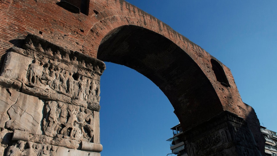
The Arch of Galerius stands at the intersection of Egnatia and Dimitriou Gounari streets. It celebrated the victory of Galerius over the Sassanids at the Battle of Satala and the capture of Ctesiphon in 298. The monument began as an octopylon, an eight-pillared gateway with three arches. It therefore stood above a main junction of the Roman street plan. A Thessaloniki walking tour can locate it on the Via Egnatia, the major Roman east-west road through the city.
The central opening was 9.7 metres wide and 12.5 metres high, while the secondary openings measured 4.8 metres wide and 6.5 metres high. Brick and rubble masonry formed the core, and marble panels carried sculptural reliefs. Two pillars beside the central passage still preserve scenes of the wars of Galerius against the Sassanids. A Thessaloniki walking tour examines these reliefs as public images of Roman authority.
Galerius commissioned the arch and the Rotunda as elements of an imperial precinct linked to his Thessaloniki palace. A road passed through the arch, joining the Rotunda 125 metres northeast with the palace complex 235 metres southwest. Three of the eight pillars and parts of the arches survive. A Thessaloniki walking tour uses the remains to map a complex that once crossed the Roman city.
- Local name: The Arch of Galerius is widely known in Thessaloniki as the Kamara.
- Purpose: The arch marked the victory of Galerius over the Sassanids and was dedicated in 303 AD.
- Reliefs: Marble panels on surviving pillars show scenes from the conflict with the Sassanids.
- Imperial plan: A Thessaloniki walking tour follows the link between the arch, the Rotunda and the palace complex.
A Thessaloniki walking tour at the Kamara puts Roman political messaging at street level. The gateway once formed a large ceremonial passage, while its reliefs recorded imperial success in stone. The links with the Rotunda and the palace reveal an organised precinct rather than separate monuments, and partial survival still allows the route to trace the scale of that Roman project.
What does a Thessaloniki walking tour see at the Roman Forum?
A Thessaloniki walking tour sees the Roman Forum, also called the Ancient Agora, as a two-terraced civic complex above Aristotelous Square. Its stoas, odeum, baths and small theatre show where formal public activity took place in the Roman city.
The Roman Forum lies on the upper side of Aristotelous Square. It has two terraces and two-storey stoas, which were found by accident during excavations in the 1960s. The complex includes two Roman baths: one has been excavated and the other remains beneath the city. The excavation revealed the two terraces at different levels of the modern city. A Thessaloniki walking tour can use the exposed levels to show how an ancient public area sits below the present street network.
A small theatre within the forum also served for gladiatorial games. The complex was largely refurbished in the second century, and the forum and theatre continued in use until at least the sixth century. The Roman odeum remains a central feature of the archaeological site. A Thessaloniki walking tour can distinguish the odeum, used for performances, from the wider open civic spaces.
The site was once planned for the Thessaloniki Municipal Courthouse. When excavations exposed the ruins, the project was abandoned and moved elsewhere. The intended name, Dikastirion Square, stayed in popular use, while the official square name became Ancient Agora. A Thessaloniki walking tour shows how a discovery changed a modern building plan and preserved the Roman centre of the city.
- Layout: The Roman Forum is a two-terraced complex with two-storey stoas above Aristotelous Square.
- Performance space: The Roman odeum formed part of the forum, and the small theatre hosted gladiatorial games.
- Roman baths: One bath has been excavated, while another remains buried beneath Thessaloniki.
- Modern impact: A Thessaloniki walking tour reaches ruins found in the 1960s that stopped a courthouse project.
A Thessaloniki walking tour at the Roman Forum makes the civic side of ancient life visible. The terraces, stoas, baths and odeum reveal an organised public complex rather than a single ruin. The site also explains why the central city includes open archaeological ground beside modern streets, and its discovery preserved material that had remained below the urban surface for centuries.
Why does a Thessaloniki walking tour visit the Church of Saint Demetrios?
A Thessaloniki walking tour visits the Church of Saint Demetrios because it is the main sanctuary of the patron saint of the city. The five-aisled basilica keeps early Byzantine mosaics, a crypt with Roman remains and a place in the UNESCO World Heritage property.
Saint Demetrius was a Christian martyr of the early fourth century and the patron saint of Thessaloniki. According to early accounts, he was born in the city in 270 and executed there around 306. The first church on this site was built in the early fourth century over a Roman bath, and the basilica became an important shrine in the city. A Thessaloniki walking tour joins the civic importance of the saint with the archaeology below the basilica.
After repeated fires, the church was rebuilt as a five-aisled basilica in 629–634. Six mosaic panels survive from the period before Byzantine Iconoclasm, showing Saint Demetrius with officials linked to rebuilding work and with children. A Thessaloniki walking tour uses this imagery to show how sacred art connected a revered figure with the protection of the city and with communal memory.
During Ottoman rule the church became the Kasımiye Camii. The Great Thessaloniki Fire of 1917 destroyed its roof and upper walls, and restoration took decades. Excavations in the 1930s and 1940s found Roman bath remains, a well and other artefacts beneath the church, and the basilica was reconsecrated in 1949. A Thessaloniki walking tour can enter the crypt museum to see the archaeological context.
- Patron saint: Saint Demetrius is the patron saint of Thessaloniki, and the church is his main sanctuary.
- Basilica form: The surviving church follows the five-aisled basilica plan established in 629–634.
- Surviving art: Six early Byzantine mosaic panels remain inside the Church of Saint Demetrios.
- Heritage status: A Thessaloniki walking tour reaches a monument within the UNESCO property inscribed in 1988.
A Thessaloniki walking tour visits Saint Demetrios for faith, art and archaeology in one place. The basilica stands above Roman remains and preserves mosaics from the early Byzantine period. Its conversion, fire damage and restoration also show changes that affected the whole city, and the crypt gives the visit a direct link between sacred tradition and the layers below.
Which Byzantine churches does a Thessaloniki walking tour see?
A Thessaloniki walking tour sees Byzantine churches that span early Christian and medieval Thessaloniki, including Hagia Sophia, the Church of the Acheiropoietos, Hosios David and Panagia Chalkeon. They show basilica, domed and cross-in-square forms within the UNESCO-listed monuments.
Hagia Sophia has a current structure dating from the seventh century, on the site of an earlier church that collapsed in 620. Its plan is a domed Greek cross basilica, and its dome mosaic depicts the Ascension. Ottoman authorities converted it into a mosque after the capture of Thessaloniki in 1430, and it returned to church use in 1912. Byzantine historian Charles Diehl restored the building between 1907 and 1909. A Thessaloniki walking tour can compare this domed plan with nearby basilicas.
The Church of the Acheiropoietos is a fifth-century church dated from its bricks and mosaics to around 450–470. It is a three-aisled basilica with a wooden roof, marble columns and fragments of fifth-century mosaics. After the Ottoman conquest in 1430 it became the first church in the city converted into a mosque. A Thessaloniki walking tour links its early Byzantine fabric with later religious change.
Hosios David was the katholikon of the Latomos Monastery in Byzantine times and contains the fifth-century apse mosaic called the Icon of Christ of Latomos. Panagia Chalkeon was built in 1028 by Christopher, katepano of Longobardia, with his family. Its brick construction, four columns and three domes create a cross-in-square plan. A Thessaloniki walking tour compares forms, materials and mosaic traditions across the city.
- Hagia Sophia: The seventh-century church has a domed Greek cross basilica plan and an Ascension mosaic.
- Acheiropoietos: This fifth-century three-aisled basilica keeps marble, columns and decorative mosaics.
- Hosios David: The former Latomos Monastery church preserves the fifth-century Icon of Christ of Latomos mosaic.
- Panagia Chalkeon: A Thessaloniki walking tour sees a brick cross-in-square church built in 1028.
UNESCO inscribed the Paleochristian and Byzantine Monuments of Thessalonika in 1988. The property includes churches, walls, a bath and the Rotunda. A Thessaloniki walking tour connects the named churches through their different plans and decoration, giving a clear record of early Christian and Byzantine architecture within a living modern city.
What does a Thessaloniki walking tour see in Ano Poli?
A Thessaloniki walking tour sees Ano Poli, the Upper Town, as the historic district around the acropolis. Its stone-paved lanes, traditional Greek and Ottoman houses, the Heptapyrgion and Vlatades Monastery preserve a city pattern that survived the Great Fire of 1917.
Ano Poli lies north of the city centre around the acropolis and is the highest part of Thessaloniki. The district preserves Byzantine and Ottoman structures and its older urban design. Small stone-paved streets, old squares and traditional Greek and Ottoman houses define the local pattern. A Thessaloniki walking tour moves uphill through a setting distinct from the rebuilt central area near the waterfront.
The Heptapyrgion stands at the northeastern corner of the acropolis. Its Greek and Ottoman names both mean Fortress of Seven Towers, although it has ten towers. It formed the major redoubt of the acropolis and housed the Ottoman garrison commander until the late nineteenth century. It later became a prison, which remained open until 1989. Restoration and archaeological work on the fortress began in the 1970s and continues. A Thessaloniki walking tour reads the complex as a defensive site with a later penal role.
Vlatades Monastery stands in Ano Poli and was built in the fourteenth century during the late Byzantine era. It is one of the Paleochristian and Byzantine Monuments of Thessaloniki on the UNESCO World Heritage List. The monastery forms part of the surviving religious landscape of the Upper Town. A Thessaloniki walking tour pairs this site with the acropolis setting to show how monastic and defensive spaces occupied the higher ground.
- District: Ano Poli is the old town of Thessaloniki around the acropolis, north of the city centre.
- Street pattern: Stone-paved lanes, old squares and Greek and Ottoman houses survive in the Upper Town.
- Fortress: The Heptapyrgion has ten towers despite a name meaning Fortress of Seven Towers.
- Monastery: A Thessaloniki walking tour reaches Vlatades Monastery, a fourteenth-century UNESCO monument.
A Thessaloniki walking tour in Ano Poli moves from the level streets below to higher ground. The district keeps an older urban pattern because it escaped the Great Fire of 1917. The Heptapyrgion and Vlatades Monastery place defensive and religious history above the centre. Across the gulf, Mount Olympus can be seen on clear days, about 80 kilometres away.
What does a Thessaloniki walking tour see on the city walls?
A Thessaloniki walking tour climbs to the Byzantine walls, a four-kilometre circuit that UNESCO lists among the Paleochristian and Byzantine monuments of Thessaloniki. The Thessaloniki walking tour follows the northern stretch beside the acropolis, passes the Heptapyrgion fortress and looks down over the old town.
The standing masonry belongs to the early Byzantine period, from about 390, and it reuses stone from an earlier wall of the late third century. A Roman wall of that era measured 1.65 metres across and carried square towers, and it held off two Gothic attacks in 254 and 268. The northern stretch climbs to the acropolis, which formed a separate fortified enclosure.
The seaward section came down in the late nineteenth century, when the Ottoman authorities reshaped the waterfront, so the surviving walls now run inland. The Heptapyrgion stands in the north-eastern corner of the acropolis, and its name, fortress of seven towers, sits oddly on a fort that holds ten. It served as the seat of the garrison commander and later as a prison, which closed in 1989.
In 904 a Saracen fleet took the city from the sea, and the seaward defences were strengthened afterwards. The main street of the ancient city ran from the Golden Gate in the west to the Cassandreot Gate in the east, and the southern wall once extended past the line of today’s Tsimiski Street. The wall was improved again in the seventh century, when the city faced attacks from the Avars and the Slavs. A Thessaloniki walking tour on the ridge reads that long record in stone.
- Listing: UNESCO added the walls to its World Heritage list in 1988.
- Building stone: ashlar blocks alternate with bands of brick, the technique of late Roman masons.
- Trigonion tower: the tower on the eastern line of the walls is open to the public.
- Free entry: the Heptapyrgion holds two permanent exhibitions and admits visitors without charge.
A Thessaloniki walking tour that reaches the walls ends above the rooftops of the upper town. From the ridge of the acropolis the gulf opens out, and on clear days Mount Olympus stands about eighty kilometres away across the water. The lanes that lead back down keep stretches of the Byzantine and Ottoman street plan, ground that the fire of 1917 never touched.
How does a Thessaloniki walking tour follow the Jewish history of the city?
A Thessaloniki walking tour follows the Sephardic story from Agiou Mina Street to Eleftherias Square. The Thessaloniki walking tour stops at the Jewish Museum in a building of 1904, at the Monastirioton synagogue of 1927 and at the Holocaust memorial placed on the square in 2006.
Sephardic Jews reached the city after the Alhambra Decree of 1492 drove them from Spain, and families from Castile, Sicily, Aragon, Naples, Venice and Provence joined them in the following years. An Ottoman census of 1519 recorded 3,143 Jewish households and 930 Jewish bachelors, which points to about 16,500 Jewish residents. The sixteenth century became a golden age of scholarship and printing. Newspapers in Ladino, the language the community brought from Iberia, appeared in the city from 1875.
In 1943 the Jewish population was confined to a ghetto beside the rail lines and deported from it. More than ninety per cent of the Jews of the city were murdered in the camps, and the community that had numbered in the tens of thousands fell to about 1,200 people today. The Holocaust memorial carries plaques that remember 50,000 Jewish Greeks of Thessaloniki and their deportation in the spring of 1943.
The museum gathers business documents from the city through a research programme that began in 2005, and the record shows Jewish-owned firms in a leading position in local commerce until 1940. Tombstones from the destroyed Jewish cemetery stand on the ground floor. A Thessaloniki walking tour that studies these rooms meets the commercial past of the city through paper rather than stone.
- Jewish Museum: the museum opened in 2001 at 13 Agiou Mina Street, and a Thessaloniki walking tour reaches it on foot from the centre.
- Monastirioton synagogue: the congregation from Monastir completed it in 1927 to designs by Ernst Loewy, and the Red Cross saved it during the war.
- Holocaust memorial: Menorah in flames was created in 1997 by Nandor Glid and installed on Eleftherias Square in 2006.
The museum holds stones and inscriptions from the great Jewish necropolis that lay east of the old walls, with photographs of the cemetery taken in 1914. Display cases on the upper floors explain Jewish life in the city from the third century BCE to the war. A Thessaloniki walking tour that ends here closes the loop between the walls above and the quarter below them.
What does a Thessaloniki walking tour see of Ottoman Thessaloniki?
A Thessaloniki walking tour reads Ottoman Thessaloniki in its baths, markets and mosques. The Thessaloniki walking tour passes the Bey Hamam of 1444, the Bedesten built under Mehmed II, the Hamza Bey Mosque and the Yeni Mosque of 1902.
Bey Hamam went up in 1444 under Sultan Murad II and counts as the first Ottoman bath in the city and the finest one left in Greece. It stands on Egnatia Street and follows a double plan with separate quarters for men and women. The men’s side opens into an octagonal cold room under a painted dome, then through tepid and hot rooms where bathers rested on marble benches. A large rectangular cistern flanks the baths on the east side and secured their water supply.
The Bedesten dates from the reign of Sultan Mehmed II, around 1455 to 1459, and stands on Venizelou and Solomou streets near the Hamza Bey Mosque. It is a rectangular hall with an entrance on each of four sides, six quadrilateral rooms, seven double arches resting on two central piers and six lead-covered domes. Before the fire of 1917 it housed 113 shops, and shopfronts ring the building today.
The Hamza Bey Mosque was built between 1467 and 1468 by order of Hafsa Hatun and named for Hamza Bey, the beylerbey of Rumeli. Earthquakes and fires damaged it, the building was rebuilt in 1620, and it was abandoned as a mosque in the 1820s. The Yeni Mosque measures 23.3 metres by 14.9 metres, held the city’s archaeological collection from 1925 until 1962, and stands near the house where Mustafa Kemal Atatürk was born in 1881.
- Bey Hamam: the double bath on Egnatia Street served bathers until 1968 and now hosts cultural events.
- Bedesten: the covered market rose under Mehmed II in the fifteenth century, and a Thessaloniki walking tour passes its six domes on Venizelou Street.
- Yeni Mosque: the Italian architect Vitaliano Poselli designed it in 1902, and it was the last mosque built in the city under Ottoman rule.
The Yeni Mosque stands in the Hamidiye district, and the Dönmeh community it served numbered between 10,000 and 15,000 people at the time of construction. The house where the founder of modern Turkey was born keeps authentic furniture and a pomegranate tree planted by his father in the courtyard. A Thessaloniki walking tour that threads these monuments covers five centuries of Ottoman rule.
Which museums does a Thessaloniki walking tour pass?
A Thessaloniki walking tour passes the Archaeological Museum, which holds around 50,000 objects, and the Museum of Byzantine Culture, which opened in 1994. The Thessaloniki walking tour also passes the White Tower museum, the Jewish Museum and the house museum at the birthplace of Mustafa Kemal Atatürk.
The Archaeological Museum was established in 1912 and occupies a building designed by Patroklos Karantinos, completed in 1962. A new wing arrived in 1980 and displayed the finds from Vergina until 1997. Renovation work in 2001 and 2004 preceded the Athens Olympics. Displays run from prehistoric material through the archaic, classical, Hellenistic and Roman periods, with the Derveni krater, the Derveni papyrus and casts of Las Incantadas among the exhibits.
The Museum of Byzantine Culture came out of an architectural competition announced in 1977, which Kyriakos Krokos won. Building work began in March 1989 and finished in October 1993, antiquities arrived from Athens in June 1994, and the museum opened on 11 September 1994. Eleven permanent exhibitions are recorded, beginning with early Christian churches, cities and dwellings. Educational programmes for schoolchildren have run from 1998.
- Archaeological Museum: the collection numbers around 50,000 objects from Thessaloniki and the wider region of Macedonia.
- Museum of Byzantine Culture: its eleven permanent displays cover the early Christian, Byzantine and post-Byzantine centuries.
- White Tower: the tower stands 33.9 metres high with a diameter of 22.7 metres, and houses an exhibition on the history of the city.
- Jewish Museum: a Thessaloniki walking tour reaches it on foot from the commercial centre.
The White Tower exhibition was organised by the Museum of Byzantine Culture, and the building is administered by the Ephorate of Byzantine Antiquities of the Greek Ministry of Culture. The house museum of Atatürk stands next to the Turkish consulate on Apostolou Pavlou Street and was given to the Turkish state in 1935. A Thessaloniki walking tour gains from this concentration, since these collections sit close together.
What does a Thessaloniki walking tour see along Egnatia Street?
A Thessaloniki walking tour treats Egnatia Street as its spine, the commercial artery of downtown Thessaloniki, named for the Roman Via Egnatia. The Thessaloniki walking tour passes above the ancient road, which lies 5.4 metres below the modern surface of the street.
The Via Egnatia was built in the second century BC, and bilingual inscriptions on milestones record that Gnaeus Egnatius, proconsul of Macedonia, ordered the work. The road ran from Dyrrachium on the Adriatic to Byzantium, later Constantinople and now Istanbul, over a distance of about 1,120 kilometres, or 746 Roman miles. It was about six metres wide and paved with large polygonal stone slabs or a hard layer of sand. The route tied the Roman colonies of the southern Balkans to Rome.
Egnatia Street runs from Demokratias Square, known as Vardari, to Konstantinou Karamanli and forms part of the Nea Diagonios corridor between the centre and the neighbourhood of Foinikas. Shops and office buildings line both sides, and a Thessaloniki walking tour finds the street among the busiest in the city. The metro tunnels follow it for part of their length, and the dig that accompanied construction counted as the largest archaeological excavation in the history of northern Greece, covering twenty square kilometres.
- Name: the street takes its name from the Via Egnatia, the Roman road that passed near the city.
- Route: it links Demokratias Square with Konstantinou Karamanli.
- Beneath the surface: the Decumanus Maximus, the main street of ancient Thessaloniki, lies 5.4 metres down.
At Venizelou station 75 metres of a marble-paved, column-lined Byzantine road came to light, and a crossroads marked by a tetrapylon was found where the main street met a north-south road. One scholar described the buried roadway as a Byzantine Pompeii. A Thessaloniki walking tour that follows Egnatia Street therefore walks on two levels at once, on the pavement of the present and above a Roman artery.
How did the Great Fire of 1917 shape a Thessaloniki walking tour?
A Thessaloniki walking tour crosses ground laid out after the Great Fire of 1917, which destroyed two thirds of the city and left more than 70,000 homeless. The Thessaloniki walking tour follows the replanning by the French architect Ernest Hébrard, whose work is still visible in Aristotelous Square.
The fire began on 5 August 1917 by the Julian calendar, or 18 August by the new one, in a small house of refugees at Olympiados 3 in the Mevlane district. Wind carried the flames through the centre, the city had no organised fire brigade, and the Allied forces then based in Thessaloniki controlled the water reserves. The blaze burned for 32 hours and destroyed 9,500 houses inside an area of about one square kilometre.
Official documents put the loss at thirty-two per cent of the city. The town hall, the post office, the telegraph office, the Ottoman Bank, the National Bank of Greece, parts of the church of Saint Demetrius, the seat of the chief rabbi with its archive and the printing houses of the newspapers were among the buildings lost. Sixteen of the thirty-three synagogues burned. Of the 7,695 shops in the city, 4,096 were destroyed, and seventy per cent of the workforce lost its employment.
Rather than rebuild at speed, the government commissioned Ernest Hébrard to design the burned zone and the future growth of the city. His scheme survives in the shape of the centre and in Aristotelous Square, although his grander proposals were never completed for lack of funds. Half of the Jewish population left the city after the fire, since their livelihoods had gone. A Thessaloniki walking tour over this ground passes the line where the old town ends and the twentieth-century grid begins.
- Date: the fire started on 18 August 1917.
- Damage: 9,500 houses were destroyed across about one square kilometre.
- Plan: the French architect Ernest Hébrard designed the burned zone and the future growth of the city.
- Legacy: Aristotelous Square shows his ideas, and a Thessaloniki walking tour still follows his streets.
The rebuilt centre gave Thessaloniki wide streets and a regular grid that a walker follows today. Blocks laid out after the fire hold the banks, hotels and offices that surround the older monuments, so the townscape shifts between Byzantine brick and twentieth-century masonry within a short distance. A Thessaloniki walking tour that notices this change reads the fire as the event that drew the modern city over the medieval one.
Which statues and modern landmarks does a Thessaloniki walking tour see?
A Thessaloniki walking tour meets the equestrian statue of Alexander the Great on the promenade, placed in 1973 and made by the sculptor Evangelos Moustakas. The Thessaloniki walking tour also passes the Umbrellas sculpture by George Zongolopoulos and the Concert Hall on Maria Callas Street.
The city holds around 150 statues or busts, and the best known is the equestrian bronze of Alexander the Great on the promenade. Other works include King Constantine in Demokratias Square by Georgios Dimitriades, Eleftherios Venizelos by Giannis Pappas, Pavlos Melas by Natalia Mela, Emmanouel Pappas by Memos Makris, Chrysostomos of Smyrna by Athanasios Apartis, Aristotle on Aristotelous Square and Philip II of Macedon opposite the White Tower.
George Zongolopoulos introduced the Umbrellas theme in 1988 and returned to it in later years. Umbrellas sculptures also stand in Thessaloniki on the new seaside and outside the Macedonian Museum of Contemporary Art.
- Statue of Alexander the Great: the equestrian bronze on the promenade was placed in 1973.
- Umbrellas: the sculpture group by George Zongolopoulos stands on the new seaside, and a Thessaloniki walking tour reaches it on the promenade.
- Thessaloniki Concert Hall: the hall opened in 2000 on land donated by the Greek state, and the main auditorium seats 1,400 people.
The Concert Hall complex holds two main buildings, M1 and M2, the second in a more contemporary style by the Japanese architect Arata Isozaki with smaller performance spaces. Concerts, opera and conferences fill its calendar, and educational work runs alongside the programme. A Thessaloniki walking tour that reaches this part of the waterfront passes from a mounted Macedonian king to a stainless steel field of open umbrellas.
How does a Thessaloniki walking tour reach the city?
A Thessaloniki walking tour begins at the airport, 13 kilometres southeast of the city, or at the railway station, the port or a metro stop. The Thessaloniki walking tour starts in the centre, where the port and the railway station both stand within easy reach.
Thessaloniki Airport carries the name Makedonia and the code SKG. It opened in 1930 and gained a second terminal at the beginning of 2021. It ranks as the third-largest airport in the country and the main air gateway to northern Greece, and it serves the Chalkidiki peninsula and the towns of Macedonia as well as the city. The Athens to Thessaloniki route carries about 1.8 million passengers.
The passenger terminal of the port was built between 1909 and 1912 by the architect Eli Modiano from designs by Alexander Vallaury, and it counts as one of the largest passenger terminals in the Aegean basin. Ferries link the city with the islands of the Northeast Aegean, the Cyclades and the Sporades, and with Izmir. The port covers 155 hectares beside the centre. The railway station stands on Monastiriou Street with seven platforms and nine tracks.
- Airport: Makedonia Airport serves the city from the district of Thermi.
- Port: a passenger terminal built between 1909 and 1912, with ferry routes to the Aegean islands and to Izmir.
- Railway station: 28 Monastiriou Street, with seven platforms and nine tracks, plus links to the metro and the intercity buses.
- Metro: the line runs below Egnatia Street through the historic centre, and the network counts eighteen stations.
Buses fill the gaps between these points. The city transport organisation was founded in 1957, runs 267 routes and operates a fleet of about 360 vehicles as the sole provider of public transport in the city. For time beyond the streets, the airport serves the Chalkidiki peninsula, and a boat trip along the Halkidiki coast follows naturally from a Thessaloniki walking tour.
Which villas does a Thessaloniki walking tour see on Vasilissis Olgas Avenue?
A Thessaloniki walking tour sees Villa Allatini, Villa Bianca and Villa Mehmet Kapanci along Vasilissis Olgas Avenue. Italian architects designed these late nineteenth-century and early twentieth-century mansions for private owners, and each building now serves public, cultural or administrative purposes.
Vasilissis Olgas Avenue belongs to the former Exochon avenue, called Rue des Campagnes. Until the 1920s the road was the home of the wealthiest residents of the city and formed its outermost suburbs, where nineteenth-century holiday villas defined the area. A Thessaloniki walking tour finds Villa Allatini there, a three-storey baroque building that the Italian architect Vitaliano Poselli built in 1898 as a countryside residence of the Jewish Allatini family of Salonica.
After the Young Turks movement emerged, Sultan Abdul Hamid II lived in Villa Allatini under house arrest from 1909 until 1911. In 1926 the villa housed the Philosophical School, the only department of the newly founded University of Thessaloniki, and it served as a hospital during the Greco-Italian War. The Prefecture of Thessaloniki held its headquarters there from 1979, and the villa now houses the administration of the region of Central Macedonia.
Pietro Arrigoni, an Italian architect from Milan, designed Villa Bianca and Villa Mehmet Kapanci. Villa Bianca, also called Casa Bianca or Villa Fernandez, was built between 1911 and 1913 as the residence of Dino Fernandez Diaz, a wealthy merchant and industrialist of Sephardi Jewish origin, and it has eclectic architectural elements. Villa Mehmet Kapanci, also written Kapandji, was built between 1890 and 1895. A Thessaloniki walking tour reads both villas as the work of one architect.
- Villa Allatini: Poselli also designed the Mills of Allatini and the Banque de Salonique head office.
- Villa Bianca: The villa has housed the Municipal Art Gallery since 2013.
- Villa Mehmet Kapanci: The Cultural Center of the National Bank of Greece was established in the restored villa in 1989.
A Thessaloniki walking tour on Vasilissis Olgas Avenue connects Villa Allatini, Villa Bianca and Villa Mehmet Kapanci, three villas built between 1890 and 1913 by Italian architects. Today the buildings serve regional administration, municipal art and a bank foundation, so a Thessaloniki walking tour reads the avenue as a record of private wealth that now serves public life.
When is the best season for a Thessaloniki walking tour?
A Thessaloniki walking tour suits spring and autumn, when temperatures sit between the cool, frosty winters and the hot summers of the city. The Thessaloniki walking tour avoids the summer heat, when the city records an average of 32 days above 32 degrees, and meets the autumn festivals.
The climate of Thessaloniki is transitional and sits on the edge of more than one zone. Under the Köppen classification the city has a cold semi-arid climate, and a small part of the centre, warmed by the urban heat island, borders a hot semi-arid one. Mediterranean and humid subtropical influences also appear, while the Pindus range dries the westerly winds. Winters are cool and somewhat dry with cold nights, morning frost is common, and the coldest month, January, averages 8 °C over the day.
Summers are hot and moderately dry. July and August average around 28 °C across the day, a sea breeze from the Thermaic Gulf moderates the heat, and the record maximum stands at 44 °C against a record minimum of −14 °C. Frost occurs on 32 days in an average year, and fog on about 17 days, mainly in autumn and winter. Rain falls in summer mainly during thunderstorms, and January and February bring the windiest weeks of the year.
Festivals mark the calendar of the city. The Thessaloniki International Film Festival runs every November and was founded in 1960, and the documentary festival fills March. The international fair opens in the first week of September, and the feast of Saint Demetrios, the patron saint of Thessaloniki, falls on 26 October. A Thessaloniki walking tour in spring or autumn therefore catches the mildest weather and the densest calendar of events.
- Summer: July and August average about 28 °C, and the temperature passes 32 °C on 32 days in an average year.
- Winter: January averages 8 °C, with frost on 32 days and snow in nearly every winter.
- Film festival: the Thessaloniki International Film Festival draws an audience of more than 80,000 people, with screenings at the Olympion theater on Aristotelous Square and in restored warehouses at the port.
The film festival was launched as a national event in 1960 under the name Greek Film Week and grew into a platform for independent cinema. Its November programme fills the centre with guests from abroad and gives the city a second season of visitors. A Thessaloniki walking tour that avoids the summer peak finds the streets given over to festival crowds instead.
What do travelers ask about a Thessaloniki walking tour?
A Thessaloniki walking tour raises questions about hills, children, distance and day trips. The Thessaloniki walking tour can stay in the flat centre or climb to the walls, and it suits families who plan a flexible route at their own pace.
Is a Thessaloniki walking tour hard on the legs?
The upper town is the highest part of the city and the acropolis dominates it, so a Thessaloniki walking tour that climbs there works on a slope. Streets in that quarter are small and stone-paved, and the old walls still surround them. The lower centre lies flat beside the gulf, and a route through it avoids the climb.
Does a Thessaloniki walking tour suit children?
The distances are modest. The wall circuit measures about four kilometres, Egnatia Street about three, and the museums stand close together near the centre. A Thessaloniki walking tour for a family can swap the acropolis climb for the flat waterfront, the statues that dot the city and the tower exhibition, which tells the story of Thessaloniki in short sections.
How much can a Thessaloniki walking tour cover in one outing?
The centre packs distinct layers into a small area. Egnatia Street carries the Roman road 5.4 metres below it, the Byzantine walls rise four kilometres around the old town, and Ottoman baths, markets and mosques sit on one short stretch. A Thessaloniki walking tour can touch three or four periods without leaving the middle of the city.
Can a Thessaloniki walking tour be paired with a food tour?
It can. The commercial streets of the centre carry the food traditions of the city, and separate food-focused outings cover that ground in depth. A Thessaloniki walking tour that ends near the middle of town leaves the afternoon free for tasting sessions, and the two activities need no transport between them, since the centre is compact.
Which day trips leave the city after a Thessaloniki walking tour?
Vergina, the site of ancient Aigai, holds UNESCO World Heritage status. Philip II was assassinated in its theatre in 336 BC, and his son Alexander the Great was proclaimed king there. Three tombs came to light in 1977, and the royal tombs museum displays their contents. A day trip to Vergina pairs well with a Thessaloniki walking tour.
Featured photo: Annatsach, CC BY-SA 4.0, via Wikimedia Commons.