A Katakolon shore excursion takes cruise passengers from the port of Katakolo on the west coast of the Peloponnese to Ancient Olympia, the sanctuary of Zeus where the Olympic Games began, and back to the ship. This post covers what a Katakolon shore excursion includes, the port, the road and railway to Olympia, the temples, the stadium, the museums, Pyrgos, the beaches, wine and food, Kaiafas, the modern Olympic revival, nearby sites, accessibility and the best season. It is one of the shore excursions in Greece on Greece VIP.
Each section ends with a Katakolon shore excursion or Olympia tour that can be booked online.
What does a Katakolon shore excursion include?
A Katakolon shore excursion carries cruise passengers from the port village of Katakolo to Ancient Olympia and back, with stops at the walled sanctuary, the ruined temples, the ancient stadium and the green valley of the western Peloponnese in Greece, all within easy reach of the harbour.
The road inland leaves the coast and crosses a district of low hills, forests and farmland. Travelers ride in a coach or a smaller vehicle for the transfer, then walk the ruins on foot. The return to the harbour comes well before the ship sails, so the schedule fits the call of the vessel. Groups leave the quay after breakfast and follow the same road back later in the day, and the land rises gently away from the sea. The plain opens out on either side.
The site spreads over a wide area at the foot of a low hill, and the monuments stand well apart from one another. Groups move from the walled enclosure to the temple platforms and then to the stadium, which lies beyond the wall to the east. A tour leader explains the ruins along the way, and travelers who want to compare formats can review the Ancient Olympia tour before booking. The route through the site follows shaded paths and open ground in turn. The group stays together throughout.
Walking covers uneven ground, gravel paths and open grass, so firm shoes help. Shade is scarce on the stadium track, and heat builds quickly after midday in summer. The ground inside the sanctuary is flatter, with paved sections around the temple platforms, while the stadium lies along a grassy bank where spectators once stood. The surface changes from gravel to grass as the route leaves the sanctuary for the arena, and the pace of the walk stays easy. Water and a hat are worth carrying in the warmer months.
- The transfer: the vehicle ride from the port to the ruins and back to the ship.
- The sanctuary: the walled enclosure with its altars, temple platforms and sacred grove.
- The stadium: the long track east of the wall, where the races were run.
- The landscape: the plain of Elis between the coast and the inland hills.
Passengers step off the coach with the layout of the site in mind: the walled enclosure, the temples and the stadium track. A Katakolon shore excursion ends at the harbour, where the village streets and the ship sit within sight of one another. The day moves at a steady pace, with time for photographs at the ruins before the return road. The quay sits at the end of the route.


What is the port of a Katakolon shore excursion?
A Katakolon shore excursion starts at Katakolo, a seaside village and cruise port on a headland in the regional unit of Elis in western Greece, where the harbour looks out over the Ionian Sea and takes the ships that bring passengers to the ruins of Olympia.
Katakolo is a community of the municipality of Pyrgos, in the western part of the Peloponnese. The village sits on a headland that separates the Gulf of Kyparissia from the rest of the Ionian Sea, and the harbour lies below the streets of the settlement. The port is a popular stop for cruise ships, and passengers use it as the gateway to the ruins. The headland shelters the berths from the open water, and the quay and the village centre sit within sight of one another.
The population of the community was 511 at the 2021 census, after 513 in 2011. The railway station stands in the centre of the village, close to the harbour and the ferry port. A lighthouse on the point, built in 1865, marks the approach from the sea, and the quay lies within a short walk of the main street. Ferries and cruise ships use the same stretch of water, and the rail halt is unstaffed. The streets climb from the water to the ridge above.
The village market holds more than sixty shops, among them cafeterias and outlets for clothing and traditional Greek products. Low hills with forests stand behind the settlement, and the land rises from the quay towards the ridge above the harbour. A Katakolon shore excursion begins and ends at this small port, where the ship berths close to the village streets. The waterfront fills when a ship is in port, and the streets stay quiet between calls. The quay and the market form the centre of the village.
- The location: a headland on the western coast of the Peloponnese.
- The harbour: a berth for cruise ships with a ferry port beside it.
- The station: a rail halt in the centre of the village, a short step from the water.
- The setting: forested hills behind the headland and the Ionian Sea in front.
For travelers on a cruise call, the port is compact and easy to read. The ship berths at the quay, the village rises behind it, and the road inland leaves from the edge of the settlement. The gangway sits a short distance from the waiting vehicle, and the return to the ship is just as simple. Nothing about the port is complicated for a first-time visitor.
How does a Katakolon shore excursion travel to Olympia?
A Katakolon shore excursion reaches Olympia by road, on a route that runs inland from the coast, and the same journey can be made by rail, because a railway line links the port of Katakolo with the inland city of Pyrgos and continues east to Olympia.
Katakolo lies 11 km west of Pyrgos, and Olympia lies 16 km from Pyrgos across the plain. The road therefore covers a short coastal leg into the city and a longer inland leg beyond it. The Greek National Road 74 runs from Pyrgos to Tripoli by way of Olympia, and coaches use that road for the eastern stretch of the journey. The plain between the two towns is flat and open, so the drive keeps a steady line. Fields and low walls line the road.
A railway line also links the port with the ruins. The station at Katakolo opened in 1882, when the Pyrgos-Katakolo Railway Company built the branch, and the line was extended to Olympia in 1891. Regional trains run between the two places by way of Pyrgos, and the halt stands in the centre of the village near the harbour. The branch joins the main route at Pyrgos, and the service runs to a timetable. The station building stands beside the tracks, with waiting rooms for passengers on the platform.
Between 2007 and 2009 the rails along the route were replaced and four new trains were built for the service. Katakolo was the westernmost active station on the network of the Hellenic Railways Organisation. The line crosses farmland and small settlements, and the track keeps to the flat ground of the plain for much of the run. The ruins come into view near the end of the run. Trains and coaches share the same corridor between the coast and the site, and the line runs at ground level.
- The road: the inland route from the coast to the ruins, across the farmland of the plain.
- The rail line: a branch from the port that joins the route to Olympia.
- The stations: a halt in Katakolo and a terminus in Olympia.
- The service: three pairs of regional trains each day in each direction.
Coaches and trains both end their run near the ruins, and the return follows the same corridor back to the coast. The distances are modest, so the journey fits inside a call at the port. A Katakolon shore excursion that uses the road can pause at viewpoints on the plain, while the rail option keeps to the timetable of the line. The run ends at the quay.
What is Ancient Olympia on a Katakolon shore excursion?
Ancient Olympia on a Katakolon shore excursion is the archaeological site of a sanctuary of Zeus in the western Peloponnese, listed by UNESCO as the Archaeological Site of Olympia, where the ancient Olympic Games were held and where temples, altars and sports structures still stand.
The site occupies the valley formed by the meeting of the Alfeios and Kladeos rivers, on the south-western foot of Mount Kronios. The Kladeos flows through Olympia and forms the western border of the ruins, while the Alfeios runs on to the coast. Olympia lies about 18 km from the Gulf of Kyparissia, and the sanctuary stands on terraced ground above the water. The two rivers meet in the valley below the ruins, and their beds shape the ground on both sides of the sanctuary. The valley floor is level.
The Altis, the sacred enclosure at the centre of the site, was first formed in the tenth and ninth centuries BC, when the cult of Zeus took root there. A wall enclosed the precinct on three sides, and the hill of Kronos closed the northern end. The enclosure held the temples, the altars where the largest sacrifices were made, and the tumulus of Pelops. The precinct took its name from the sacred grove that stood inside it. The wall kept the sacred ground apart from the games area.
The ground has been occupied since prehistoric times, and pottery from the final Neolithic period was found on the north bank of the stadium. A great tumulus of the Early Helladic II period was uncovered in the lower strata of the Pelopion. Votive offerings, among them the first figurines of Zeus, date to the Geometric period. Excavation at the site has continued for well over a century, and the sanctuary served as a religious and athletic centre for the Greek world. The valley has been settled for thousands of years.
- The listing: UNESCO inscribed the Archaeological Site of Olympia in 1989 under five cultural criteria.
- The Altis: the walled enclosure measures more than 183 m on each side.
- The rivers: the Alfeios runs 112 km to the Gulf of Kyparissia, and the Kladeos joins it at Olympia.
For a visitor arriving from the coast, the ruins fill a broad green bowl between the hills and the river. A Katakolon shore excursion sets the sanctuary in that landscape, and the walk from the entrance to the stadium follows ground that was used for worship and for sport. The setting explains why the place held its position for so long. The landscape itself carries much of the story.
What does a Katakolon shore excursion see at the Temple of Zeus?
A Katakolon shore excursion sees the ruins of the Temple of Zeus, a Doric building raised in the fifth century BC by the architect Libon, which once housed the gold and ivory statue of Zeus by Phidias, one of the Seven Wonders of the Ancient World.
Construction of the temple ran from about 472 to 456 BC, and the building followed the Doric order, with six columns across the front and thirteen along each side. Two rows of seven columns divided the inner chamber into three aisles. The platform stood on three unequal steps, and a porch at the front was matched by a second porch at the back. The temple was raised on an already ancient religious site, and its form became the model of the fully developed classical Doric temple.
The temple held the statue of Zeus, a seated figure about 12.4 m tall, made of ivory plates and gold panels over a wooden frame. Phidias worked on the figure at Olympia, and the god rested on a painted cedarwood throne ornamented with ebony, ivory, gold, precious stones and wrought images. The geographer Strabo wrote that the seated figure seemed ready to lift the roof if it stood up. The statue filled half the width of the aisle of the temple built to house it.
The building lost its roof and much of its structure in late antiquity. Earthquakes shook the site in AD 522 and AD 551, and silt from the valley and landslips from the hill above gradually covered the remains. The English antiquarian Richard Chandler identified the site of the sanctuary in 1766, and French archaeologists had already excavated part of the temple in 1829. Systematic work began in 1875 under the German Archaeological Institute, and excavation has continued since that time.
- The order: the Doric design served as a model for later temples in the Peloponnese and in southern Italy.
- The sculptor: the same artist had earlier made the colossal statue of Athena Parthenos in the Parthenon.
- The statue: the figure was lost, and its form is known from ancient descriptions and from coins.
The temple dominates the centre of the sanctuary, and its columns are the first monument that visitors notice on the walk from the entrance. A Katakolon shore excursion pauses there before moving on to the older temple nearby and to the stadium. The ruins give a clear idea of the scale of the building that held the statue. The temple stood at the centre of the sanctuary.
What does a Katakolon shore excursion see at the Temple of Hera?
A Katakolon shore excursion sees the Temple of Hera, a Doric building raised around 580 BC in the north of the sanctuary, at whose altar the Olympic flame is kindled before the torch begins its journey to the host city of the modern Games.
The temple, also called the Heraion, is the oldest temple at Olympia and one of the earliest Doric temples in Greece. It was the first building on the site with a row of columns on all sides, and it stood longer and narrower than the temples of the earlier age, a shape common in early Doric work. The shrine came as a dedication from the nearby city of Skillous, and it stood at the northern end of the precinct. The wooden columns were later replaced with stone.
The building was dedicated to Hera, queen of the Greek gods, and it began as a joint shrine of Hera and Zeus. It kept that double role after a separate temple was raised for Zeus nearby, and the building is oriented east to west. The shrine was closed during the persecution of pagans in the late Roman Empire, and the structure then fell into ruin. Hera held the place of the main patron deity at the site in the earliest years of worship there. The shrine kept its role.
The altar in front of the temple is the place where the flame for the Olympic torch relay is lit, and the torch is kindled among the ruins to this day. The altar stands in the open, in front of the long platform, and the ceremony takes place there when the flame is lit. The temple was destroyed by an earthquake in the early fourth century AD, though the stone platform survived. Visitors walk along its length and look down on the columns that remain in place.
- The columns: the peristyle had six columns at the front and sixteen along each flank, and the earliest were made of wood.
- The platform: the stylobate measures 19 by 50 m.
- The treasury: offerings of value were stored inside the building during the Archaic period.
- The name: the building is known as the Heraion as well as the Temple of Hera.
The temple marks the northern edge of the walk through the sanctuary, and its long platform gives a clear sense of the early Doric plan. A Katakolon shore excursion reaches it between the larger temple and the stadium, so the three monuments sit close together on the route. The ruin keeps its long shape. The platform and the columns give a clear picture of the early Doric form.
What does a Katakolon shore excursion see at the ancient stadium?
A Katakolon shore excursion sees the ancient stadium of Olympia, a long clay track with earthen banks east of the sanctuary, where the running and wrestling events of the ancient Olympic Games took place under the open sky for the crowds that filled the banks of the arena.
The stadium lies beyond the walled enclosure, and its track measures 212.54 m from start to finish and 30 to 34 m across. The surface was made of hard-packed clay, which gave the runners grip underfoot. A white block at one end of the track aligned the athletes at the start of every race, and the sloping ground along the sides served as seating. The stadium was moved east of its earlier sites in the classical period. The track runs in a straight line from the start to the finish.
The length of the field became the standard stadion, the Greek unit of distance that appears in the work of the ancient geographers. The judges sat on a stone stand on the southern bank, and the start and the finish were marked off by transverse curbing. The stadium has been used for Olympic purposes without any intentional alteration of the ancient topography, and temporary stands can be raised and taken down again. The banks rise on the north and south sides of the arena. Spectators sat on the slopes.
The games began in 776 BC, the first year recorded in the lists of victors, and they were held every four years in honour of Zeus. Coroebus of Elis won the sprint at that first celebration and is named as the earliest champion. The programme grew over time: the double sprint was added in 724 BC, the long race in 720 BC, wrestling and the pentathlon in 708 BC, boxing in 688 BC, and the pankration in 648 BC. The games drew competitors from the Greek city-states.
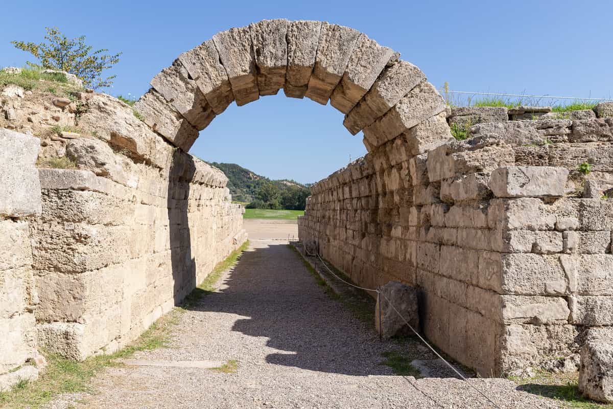
- The entrance: the Krypte, a vaulted passage that took the athletes from the sanctuary onto the track.
- The crowd: the earthen banks along the sides of the track held 45,000 spectators.
- The last games: the final recorded celebration came in AD 393.
- The modern Games: the stadium held the shot put events of the 2004 Summer Olympics.
The stadium is the last stop on the walk through the site, and the passage from the sanctuary frames the track in the same way that it did in antiquity. The visit ends on the banks where the crowds stood, before the return to the road and the coast. The quiet of the valley now replaces the noise of the festival. The ruins lie open under the sky.
What does a Katakolon shore excursion see at the Archaeological Museum of Olympia?
A Katakolon shore excursion sees the Archaeological Museum of Olympia, the principal home of the finds from the sanctuary. Its twelve exhibition rooms hold the Hermes of Praxiteles, the Nike of Paionios and the sculptured pediments of the Temple of Zeus.
The museum opened in 1888 as the first Greek museum outside Athens. A banker paid 220,000 drachmas for a neo-classical building on the hill of Drouva, designed by two German archaeologists who were digging the sanctuary. An earthquake damaged the structure in 1954, and the collections outgrew the rooms. A Katakolon shore excursion now enters a modern building with twelve exhibition rooms, arranged by theme and by age, from prehistory to the years of Roman rule. Its bronze holdings rank among the finest collections of their kind anywhere.
The Hermes of Praxiteles was found in 1877 inside the Temple of Hera, protected by a layer of clay. The group is carved from Parian marble, and the figure of the god measures 2.10 metres without the base. The front surface is polished, while the back shows the marks of the chisel. A Katakolon shore excursion sees the statue beside the Nike of Paionios, made by Paionios of Mende between 425 and 420 BC. The Nike lacks her face, wings and forearms, but the billowing drapery of the goddess survives.
The eastern pediment of the Temple of Zeus shows the chariot race between Pelops and King Oenomaus, with Zeus in the centre and the river gods Alfeios and Kladeos in the corners. An old man in the corner of the group counts as the earliest realistic portrait of age in the history of Greek art. A statue of Apollo from the western pediment appeared on the Greek 1000-drachma banknote that circulated from 1987 to 2001. A Katakolon shore excursion also passes the helmet of Miltiades, dated to 490 BC.
- Bronze collection: a Katakolon shore excursion sees one of the finest groups of bronzes in the world, with figurines, vessels and armour from the sanctuary.
- Terracottas: prehistoric, Archaic and Classical pieces form a group of their own, and a Katakolon shore excursion sees them in the same wing.
- Zeus and Ganymede: a late Archaic terracotta group shows the god carrying the youth towards the sky.
- Oenochoe: a jug that belonged to Phidias stands in the same room as the marble gods.
The museum sits beside the archaeological site, on the road from Olympia to the sanctuary, and shares one ticket with the ruins and the other Olympia museums. Groups move through the rooms in a fixed order, and a Katakolon shore excursion adds the Hermes gallery last, when the coaches begin to leave the car park. A separate building holds the museum store, on the path to the site.
Which other museums does a Katakolon shore excursion visit in Olympia?
A Katakolon shore excursion adds the Museum of the History of the Olympic Games of Antiquity, which displays more than 400 exhibits, and the Museum of the History of the Excavations in Olympia. Both are small and stand close to the site.
The Museum of the History of the Olympic Games of Antiquity occupies Olympia’s first archaeological building, which held the finds of the sanctuary until the 1970s. With the Athens Olympiad of 2004 the house became a museum of the ancient Games. Its rooms are organised in thematic groups, and the objects run from the prehistoric period to the fifth century AD. A Katakolon shore excursion spends the longest time in the gallery on the Panhellenic festivals and their shared rules, where the labels explain each contest.
The greater part of the exhibits comes from Olympia, and the rest from other important sites across Greece. Information panels, models and visual material explain the development of the Olympics and of the other Panhellenic Games: the Pythian at Delphi, the Nemean at Nemea and the Isthmian at Corinth. A Katakolon shore excursion sees how the four festivals shared truces, prizes and a crown of leaves. The basement holds a digital exhibition with texts, pictures, maps, videos and an interactive three-dimensional theatre.
The second museum explains how the site was cleared. German archaeologists opened the first campaign in 1875 under Ernst Curtius and recorded 14,000 objects. Work resumed in 1936 under Emil Kunze, then between 1972 and 1984 under Alfred Mallwitz, who found dating evidence for the stadium and the graves. From 1984 to 1996 Helmut Kyrieleis turned the dig towards the earliest history of the sanctuary. A Katakolon shore excursion hears how each campaign added to the picture of the site.
- Antiquity museum: the display sets the Olympics beside the other great festivals of the Greek world.
- Excavation museum: plans, tools and photographs follow the work of the digging teams, and a Katakolon shore excursion sees the objects they brought up.
- Room layout: exhibits are grouped by theme, so the story of the Games unfolds in stages.
- Group access: a Katakolon shore excursion walks between the two houses in a short break from the ruins.
The two museums sit between the sanctuary and the village, and together they turn a walk through ruins into a story with objects. Rain or heat rarely interrupts a visit, since the rooms are covered and the corridors are short. A Katakolon shore excursion leaves the last room with a clearer sense of how the ancient Games were run and of the crowds that once filled the site.
Which other monuments does a Katakolon shore excursion see at Olympia?
A Katakolon shore excursion sees the workshop of Phidias, the Philippeion, the Palaestra, the Gymnasium, the Leonidaion, the treasuries and the Zanes, all inside the archaeological site of Olympia. The line of monuments sits west and north of the Altis.
Phidias built the chryselephantine Zeus in a workshop beside the Temple of Zeus. The room was rediscovered between 1954 and 1958, and the finds included tools for gold and ivory, ivory chippings, precious stones and terracotta moulds, plus a cup inscribed with the name of the sculptor. The workshop lay where Pausanias placed it, and a Christian basilica was later raised over the same spot. A Katakolon shore excursion stands on the floor where the giant image took shape.
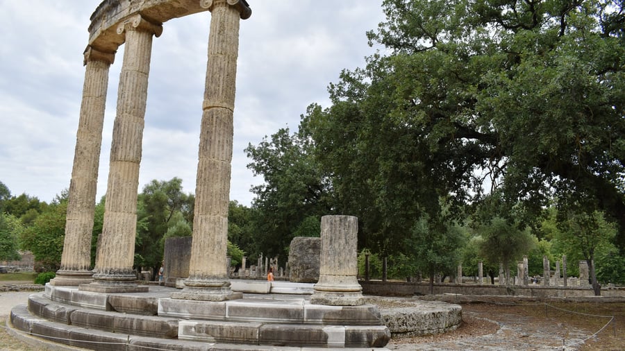
The Philippeion is a round tholos of limestone and marble, finished about 336 BC by the Athenian sculptor Leochares for the family of Philip the Second. Its outer ring carried eighteen Ionic columns, while the inner one held nine engaged Corinthian columns, and the roof was crowned with a bronze poppy. It was the only building inside the Altis raised for human beings rather than for the gods. A Katakolon shore excursion sees the marble base where the ivory portraits of the royal family once stood.
The Palaestra and the Gymnasium served the athletes. The Palaestra was built in the third century BC for wrestling, boxing and the pankration, and measures 66.35 metres by 66.75 metres. Its stone foundations carried brick walls and a wooden entablature. The Gymnasium next door held the running tracks and the wrestling grounds described by Pausanias. Water reached the complex by an aqueduct from a spring four kilometres away, donated with a fountain by Herodes Atticus. A Katakolon shore excursion walks the porticoes where pentathletes and runners trained.
- Leonidaion: the largest building on the site lodged the athletes, and a Katakolon shore excursion sees four Ionic colonnades with 138 columns.
- Treasuries: small temple-shaped houses on the north side stored the offerings of Greek colonies, from Sicyon to Gela, on a terrace below the hill of Cronus.
- Zanes: sixteen stone pedestals in front of the stadium entrance held bronze statues of Zeus paid for by fines on cheating athletes.
- Royal portraits: ivory and gold figures of Philip, Alexander and Olympias stood inside the round hall.
The monuments stand in a rough line from the Kladeos to the stadium, and each one tells a different story of money, faith and sport. A Katakolon shore excursion crosses the site on foot, since the ground between the buildings is uneven and the shade is thin. Coaches wait at the gate near the museum, and the walk between the monuments is the longest part of the visit.
What does a Katakolon shore excursion see in Pyrgos?
A Katakolon shore excursion sees Pyrgos, the capital of Elis, a lowland city of 26,052 people whose name means tower. The town lies in the middle of a plain, four kilometres from the Ionian Sea. The Alfeios river reaches the sea seven kilometres south.
The city grew from a single tower. In the 1510s a villager from Kalavryta found a store of ancient gold coins in a well and handed them to Sultan Selim the First, who made him ruler of the district in 1512 and gave him land between the Alfeios and Agios Ioannis. Raisin exports through the port of Katakolo brought wealth in the late nineteenth century, and the town spread across the plain. A Katakolon shore excursion hears the story at the heart of the town, beside the market.
The municipal market, a work by the architect Ernst Ziller, now houses the archaeological museum of the city. The same architect designed the railway station, which has trains to Katakolo and to Olympia. The town hall and the square around it form the centre, and the streets carry the produce of the plain towards the coast. The bus terminal beside the station serves the villages of the regional unit. Pyrgos stands sixteen kilometres west of Olympia, sixteen kilometres southeast of Amaliada and fifteen metres above sea level.
The plain that surrounds the city is fertile land, and a third of the jobs in Elis are agricultural. Fields of maize, tomatoes, potatoes, green peppers, watermelons and melons reach the horizon, and the wet months bring nearly 900 millimetres of rain. Summers are hot and dry. A reservoir on the Alfeios supplies the city with water, and the fields draw on the same river. A Katakolon shore excursion sees the farming landscape from the coach.
- Market hall: the covered market of the city now serves as the local archaeological museum.
- Railway: a Katakolon shore excursion can ride from the station to Katakolo and to Olympia.
- Town centre: the square, the town hall and the market form a compact walk through the city.
- Climate: the mild winter and the long dry summer shape the working year of the plain, which a Katakolon shore excursion crosses in the heat of July.
Pyrgos is a working town rather than a monument, and the stop lasts long enough for a coffee and a walk. Shopfronts sell tools, cloth and food, and the pace slows in the heat of the afternoon. A Katakolon shore excursion leaves the city with the plain behind it and the port ahead.
What does a Katakolon shore excursion see in Katakolo itself?
A Katakolon shore excursion sees Katakolo, a seaside village of 511 people on a headland above the Ionian Sea, eleven kilometres west of Pyrgos. Its lighthouse dates from 1865 and the castle of Pontikokastro stands on a hill above the port.
The headland separates the Gulf of Kyparissia from the rest of the Ionian, and low forested hills ring the village. More than sixty shops line the waterfront, with cafeterias and stalls of traditional Greek goods. The Museum of Ancient Greek Technology occupies one of the buildings, and the harbour receives cruise ships whose passengers visit Olympia. Fishing boats land part of their catch for the markets of Elis. A Katakolon shore excursion steps ashore a short walk from the quay, with the whole village within sight.
Northwest of the village lies Agios Andreas, a settlement of nine people that was the natural harbour of ancient Olympia. The ancient city of Pheia occupied the same bay and now lies under water. A survey in 1973 found the remains of the town at a depth of five metres below sea level, and earlier digs brought up pottery, lamps, bowls and a marble kouros from Naxos. The bay opens west towards the island of Zakynthos. A Katakolon shore excursion looks across the water at the islet of Ichthys.
The medieval fortress of Pontikon, called Beauvoir by its Frankish lords, was built by the Byzantines and taken by the Franks around 1205. Its walls form a long rectangle with a tower twelve metres high, and a cistern in the middle. The walls are built of hewn stone. Pheia was destroyed in 551 by a tsunami that also ruined Patras, and the castle later rose on the ruins of its acropolis. A Katakolon shore excursion climbs the hill for the view over the bay and the open sea.
- Harbour: the quay takes cruise ships and fishing boats side by side through the summer.
- Castle walls: the ruin encloses about one acre, ninety metres long and fifty-five metres wide.
- Beaches: the sandy coast runs north towards Skafidia, a village of the same municipality.
- Trains: a Katakolon shore excursion can reach Pyrgos and Olympia from the village station.
The village works as a starting point and as a place to return to. The promenade runs along the water, beside the shops. Passengers walk off the ship into a street of shops, then leave for the ruins and come back for a last coffee by the water. A Katakolon shore excursion ends where it began, within sight of the lighthouse and the fishing boats.
Which wine and food does a Katakolon shore excursion taste?
A Katakolon shore excursion tastes the wines of the Peloponnese and the produce of Elis. Local tables set out olive oil, olives, tomatoes, green peppers, cheeses and honey, with fish from the Ionian Sea. Greek winemaking reaches back 6,500 years.
Greek wine carries one of two labels: a protected designation of origin or a protected geographical indication. The Peloponnese forms one of the wine regions of the country, with appellations at Nemea, Mantineia, Patras and Monemvasia. Around two hundred vine varieties grow in Greece, and four of them shape the local glass: Agiorgitiko, Roditis, Moschofilero and Mavrodaphne. The reds from Agiorgitiko are soft and fruity, while Roditis gives light white wines with citrus notes and a pale colour. White wines from Moschofilero carry a crisp floral note.
Mavrodaphne grows in the Peloponnese and on the Ionian Islands, and the sweet version carries a protected designation of origin linked to Patras. Berries are vinified in vats under the sun, fermentation is stopped with distillate, and the wine matures in underground cellars through the solera method. Its aromas run to caramel, chocolate, raisins and plums. The same grape also appears in dry red wines, which are lighter in the glass. A Katakolon shore excursion meets the darker pour at the end of a meal.
Olive oil is the base of Greek cooking, and the tree covers the hills of Elis. Orchards around Zacharo grow the Koroneiki variety, whose extra-virgin oil leaves the region for foreign markets. The plain supplies tomatoes, potatoes, melons and green peppers, and farmers keep sheep and goats for cheese. Cheeses include feta, kasseri, kefalotyri and graviera, while honey comes from citrus, thyme and pine. Fish dishes are common along the coast, and beef is rare. A Katakolon shore excursion tastes the oil with bread before the wine arrives.
- Olives: a Katakolon shore excursion meets the fruit both whole and pressed for oil.
- Seafood: the waters off Elis supply squid and fish to the tables of the coast.
- Vegetables: aubergines, okra, green beans and onions fill the summer dishes that a Katakolon shore excursion meets.
- Cheeses: feta, manouri and mizithra appear together on the same board.
Elis is farmland first, and the food follows the fields and the sea. Cellars in the hills above the plain press grapes that travel far beyond the region, and the same families sell oil and honey by the roadside. A glass of the local red closes the meal. A Katakolon shore excursion that ends with a tasting closes the day with the taste of the region.
What does a Katakolon shore excursion see at Kaiafas?
A Katakolon shore excursion sees the thermal springs of Kaiafas, which rise at 32 to 34 degrees Celsius inside a cave at the foot of Mount Lapithas, beside a lake and a long sandy beach. The springs form part of the municipality of Zacharo.
Two springs issue from a naturally formed cave in the mountain, and the water carries sulfur compounds, magnesium sulphate and calcium sulphate. Bathers have used the pools since antiquity, when the site belonged to the myth of the Anigrides, and doctors now recommend the water for diseases of the muscles and joints. The first bathing facilities were built in 1907, and the spa has drawn visitors from far away ever since. A Katakolon shore excursion takes the waters in a hall that stands at the cave mouth.
The lake opens at the mouth of the cave and lies between the mountain and the Ionian Sea. An earthquake that struck the river Anigros is thought to have created it. The springs were little used in the Byzantine and Ottoman periods, and the whole basin is protected under the Natura 2000 network. The basin holds the green alga Chara corfuensis. A hotel stands on a small island within the water. A Katakolon shore excursion sees the calm surface framed by reeds and pines.
A belt of Aleppo pine separates the lake from the sand. The beach runs for three and a half kilometres, and the wider shore of Zacharo counts among the longest in Greece, with a Blue Flag for water quality and management. Lapithas covers between 100 and 150 square kilometres, and carries pine woods that the fires of 2007 damaged badly. Zacharo keeps a health centre and a railway station. A Katakolon shore excursion walks the pines between the water and the waves.
- Zacharo: the town lies eighteen kilometres south of Olympia and keeps its patronal feast on the twelfth of December.
- Spa buildings: the state tourism organisation ran the site from 1960 until 1999.
- Gulf of Kyparissia: a Katakolon shore excursion faces the open Ionian Sea along this coast.
- Minthi: the mountain of that name rises to the east of the town.
Kaiafas combines a warm spring, a shallow lake and a wide beach in one small basin. Bathers move between the cave, the sand and the shade of the pines without leaving the site. The drive back to the port crosses the flat plain of Elis, past fields and villages, and a Katakolon shore excursion ends here with a slow walk along the water.
How does the modern Olympic revival connect to a Katakolon shore excursion?
A Katakolon shore excursion leads to Olympia, where the modern Games were reborn. Pierre de Coubertin, the French aristocrat whose campaign brought the festival back, is honoured there, and the memorial stele in the grove keeps his heart, which was carried to the site after his death.
The revival began with a congress held on 23 June 1894 in Paris, where a commission proposed that the Games return every four years and set the first modern edition for Athens. The congress accepted the plan unanimously, and the modern Olympic movement was born. That festival followed in 1896, with 14 nations and 241 athletes. UNESCO lists the sanctuary where the idea took hold, and a Katakolon shore excursion reaches the ground and the ruins that framed it.
The International Olympic Academy was established in 1961 near the archaeological site of ancient Olympia, and it serves as the main educational and cultural institution of the International Olympic Committee. Its grounds hold the marble altar that receives the flame when the torch relay begins, before the fire travels to Athens and then to the host city. Its sessions bring young people, coaches and journalists together, so a Katakolon shore excursion touches a working institution as well as a ruin.
The torch relay was introduced at the 1936 Summer Olympics in Berlin, and it has taken place before every edition since. The flame is kindled in the sanctuary, and the road that links the grove to the stadium is the same ground that a Katakolon shore excursion covers on foot. A journey that ends in a distant stadium begins here each time, in the sanctuary above the harbour, and a Katakolon shore excursion stands at the start of it.
- Founder: The International Olympic Committee was created by Pierre de Coubertin, and Demetrios Vikelas became its first president when the modern movement was founded.
- First edition: The Games of 1896 opened in Athens on 6 April and closed on 15 April, with a programme of 43 events in nine sports.
- Rewards: Winners received a silver medal and the runners-up a copper medal, and no gold medals were awarded at that edition.
- Marathon: Spyridon Louis won the marathon for Greece, the host nation, which finished the Games with 47 medals overall.
A Katakolon shore excursion carries a modern traveller from a working harbour to the birthplace of the Olympic idea. The connection is written in stone, in a heart kept at Olympia and in an academy that teaches the same values. The harbour below the village is the doorway, and the sanctuary above the valley is the destination. The village and the ruins form one continuous story.
Which other ancient sites can a Katakolon shore excursion reach?
A Katakolon shore excursion can reach Ancient Elis, the Temple of Apollo Epicurius at Bassae and the Frankish castle of Chlemoutsi above Kyllini. Elis ran the Olympic festival for more than a thousand years, while Bassae stands in the mountains and Chlemoutsi on a plateau near the coast.
Elis was an ancient polis in the northwestern Peloponnese and the capital of the city-state that controlled the sanctuary at Olympia. The Hellanodikai, the judges of the Games, were chosen from Elis and lived in the Hellanodikaion for the ten months before the festival, while athletes trained in the city for at least one month. Elis was the only fortified town in the state, and a Katakolon shore excursion that adds it to the day sees the administrative heart of the ancient festival, where the judges learned their duties.
Bassae lies at an elevation of 1,131 metres on the slopes of Cotylion, high in the mountains of the Peloponnese. The Temple of Apollo Epicurius was built between 420 and 400 BC and is attributed to Iktinos, the architect of the Parthenon. It holds the earliest surviving Corinthian capital, it is the earliest monument where the Doric, Ionic and Corinthian orders appear together, and it faces north and south rather than east and west. A Katakolon shore excursion that travels this far leaves the coast for a mountain sanctuary.
Chlemoutsi was built between 1220 and 1223 by Geoffrey of Villehardouin as the main stronghold of the Principality of Achaea, and it counts as one of the finest early Frankish fortifications preserved in Greece. The castle occupies a plateau 226 metres above sea level near Kastro-Kyllini, with views that reach the Ionian islands of Zakynthos and Cephalonia, and it was never besieged. Its walls survive in their thirteenth-century state, and a Katakolon shore excursion in this direction ends at the ferry port of Kyllini.
- Sacred way: The Hellanodikai, the athletes and their trainers walked the 58 km from Elis to Olympia along the sacred way.
- City plan: Elis was laid out on a rectangular plan that covered 150 hectares and included sanctuaries and an agora with porticos.
- Shelter: A protective shelter and a water runoff system limit the damage that extreme weather causes to the temple at Bassae.
- Farmland: About one-third of the land in Elis is fertile and the rest is mountainous, so a Katakolon shore excursion that crosses the region passes both.
The western Peloponnese keeps its past in layers. A Katakolon shore excursion can move from a classical city to a mountain temple and then to a medieval castle inside one port call, and the harbour remains the fixed point of the return. The distances between those places show how much history the region around Elis holds, and each stop answers a different century. The route inland repays the extra hours.
Which types of Katakolon shore excursion exist?
A Katakolon shore excursion takes clear practical shapes: a visit to Olympia with an expert-led walk, a private car trip, a small-group trip, or a day built around the wine, food and coast of the region. Each shape starts at the port beside the village.
The port of Katakolo is a popular stop for cruise ships, and passengers step ashore in a seaside village that sits on a headland above the Ionian Sea, separating the Gulf of Kyparissia from the rest of the water. The village lies 11 km west of Pyrgos, the capital of Elis, and low hills with forests surround it, while the quay sits beside the main street. A Katakolon shore excursion therefore begins with a short transfer rather than a city transfer, and the harbour stays within sight of the ship.
The Olympia option fills the day with one site. According to Pausanias, Olympia held over 70 temples, treasuries, altars and statues, and the sanctuary sprawls well beyond its boundary wall, so an expert-led walk turns a scatter of ruins into a sequence. The knowledge of a tour leader orders the Altis and the monuments as the sanctuary grew, and a Katakolon shore excursion of this shape keeps the group on one path. The route is short on paper, yet a Katakolon shore excursion here spends its hours inside one wall.
Trips that follow the wine and food of the region pass through the vineyards of the Peloponnese, where about 200 vine varieties are grown and where areas such as Mantineia and Patras carry protected names. The coast also draws visitors, because the sunken ancient city of Pheia lies within walking distance of the port. A Katakolon shore excursion of this kind can end with a swim or a meal beside the water, and the slopes above the coast supply what the tables serve.
- Village market: Katakolo has a market of more than sixty shops with cafeterias, restaurants, clothing and traditional Greek products.
- Museum: The Museum of Ancient Greek Technology is one of the main sites that a Katakolon shore excursion can reach inside the village.
- Ancient harbour: Agios Andreas, northwest of the village, was the natural harbour of Ancient Olympia.
Each type of Katakolon shore excursion answers a different wish. One traveller wants the sanctuary and its history, another wants the wheel of a private car, and a third wants a table by the sea. The village sits at the centre of all three, and the ship sets the clock that governs the day. The order of the stops stays flexible, and every version ends at the quay.
How does a Katakolon shore excursion compare with other Greek cruise ports?
A Katakolon shore excursion works from a small village port, unlike the city ports of Piraeus and Corfu. Piraeus serves Athens and the ferry routes to the islands, Corfu offers a World Heritage old town, and Katakolo offers a single inland sanctuary, the archaeological site of Olympia.
Piraeus is a port city within the Athens urban area, eight kilometres southwest of the city centre on the Saronic Gulf. Its harbour is the chief port in Greece and the fifth largest passenger port in Europe, and the central quays serve ferry routes to almost every island in the eastern part of the country, as well as Crete, the Cyclades and the Dodecanese. The municipality holds 168,151 residents and is the fourth largest in Greece, so a Katakolon shore excursion works on a far smaller scale.
Corfu is the northernmost of the Ionian Islands on the west coast of Greece, with an area of 610.9 square kilometres and a highest point of 906 metres. Its old town joined the World Heritage List in 2007 and keeps Venetian-era buildings, narrow lanes and the Spianada, the largest square in South-Eastern Europe. The town occupies a peninsula between two fortresses, and a Katakolon shore excursion trades that urban setting for a quiet harbour. The contrast with a village port is the point for a Katakolon shore excursion.
The three ports differ in what lies behind the quay. Olympia, the inland destination of a Katakolon shore excursion, entered the World Heritage List in 1989 as a property of 105.6 hectares, and it stands around 18 km from the Gulf of Kyparissia. UNESCO describes the Altis as holding one of the highest concentrations of masterpieces of the ancient Mediterranean world; a visitor with a day in hand weighs a sanctuary against a city or an island, while Piraeus reaches a capital and Corfu reaches a historic town.
- Olympic city: The port city of Piraeus hosted events in the 2004 Summer Olympics, when the Games returned to Athens.
- Ionian population: Corfu has 99,134 residents, a figure taken from the 2021 census, and its regional unit stretches south as far as the Paxoi.
- Capital route: Travellers who prefer a city day can compare a Piraeus shore excursion with the western itinerary.
- Island route: Travellers who prefer an island town can compare a Corfu shore excursion with the same western itinerary.
The choice depends on the kind of day a traveller wants. A Katakolon shore excursion exchanges the noise of a capital harbour for a village quay, a short inland road and a sanctuary that has drawn visitors for centuries. Piraeus and Corfu answer different questions, and both remain strong options for a Greek cruise itinerary. Each route suits a different tempo, and the western option stays the simplest.
Is a Katakolon shore excursion accessible?
A Katakolon shore excursion reaches a site that UNESCO lists as having ramps for disabled people, a new ticket office and renewed signs. The sanctuary itself, the Altis, is an irregular walled area more than 183 metres on each side, and the walk between its monuments is long.
Olympia lies in the valley of the Alfeios River, and the Kladeos forms the western border of the site. The ground is terraced into the slope of the valley, so paths rise and fall between the monuments, and the stadium surface is grass, stones and dirt rather than paving. The main route from the gate to the stadium crosses the whole terrace, and a Katakolon shore excursion that plans for uneven ground covers more of the sanctuary than a hurried walk does.
The stadium is reached through a vaulted corridor that the athletes used, and spectators sat on the sloping flanks of a field that measures 212.54 metres by 30 to 34 metres. The space once held 45,000 people, and the track was made of hard-packed clay. The corridor opens into the field and the light returns at once, so a Katakolon shore excursion that walks the clay track sees the same view as the crowd, and visitors who prefer open air pass through quickly.
Elis is more humid than the eastern Peloponnese, and summer days bring strong sun. The Altis holds the same tree and plant species as in antiquity, and those trees give the main shade on the site, while the open stadium and the terraces stay exposed. An Olympic Botanical Garden near the ruins grows flora that Pausanias described, and it gives a cool pause on the way back. A Katakolon shore excursion in high summer benefits from water, a hat and a slow pace.
- Works on site: Excavation work continues at Olympia, and the sanctuary is still being uncovered.
- Museums: Moveable finds from the site are housed in one of the three museums at Olympia.
- Walls: The Altis is walled on every side except the north, where Mount Kronos bounds it.
- Workshop: The workshop of Pheidias was found under the remains of a Byzantine church at the site.
Olympia rewards a slow visit. A Katakolon shore excursion that arrives with water, a hat and a realistic plan for the ground will see the temple platforms, the vaulted entrance and the stadium itself. The site is open, the shade is limited, and the distance between the gate and the far monuments is real, so the pace matters as much as the route. Visitors who pace themselves see it all.
When is the best season for a Katakolon shore excursion?
A Katakolon shore excursion works well in spring and autumn, when the heat of Elis eases. Summer brings strong sun and little rain, winter is mild and wet, and the Mediterranean sailing calendar keeps ships in the western Peloponnese through the warmer months.
Katakolo has a hot-summer Mediterranean climate in the Köppen classification, with hot, dry summers and mild winters that carry significant rainfall. The figures come from the Hellenic National Meteorological Service, which records mean daily maxima of 28.71 degrees Celsius in July and 29.03 degrees in August. The harbour sits on the coast of western Elis, where the sea softens the inland extremes, and a Katakolon shore excursion in the height of summer meets those maxima, while a call in winter arrives with rain on the hills.
Rainfall follows the opposite pattern. July measures 2.36 millimetres, while the wet months fall in late autumn and winter. Grey days are in the minority outside those months, and a Katakolon shore excursion in spring or autumn finds the ruins under long, even light. The dry weeks keep the tracks firm and the paths open for walking.
Inland, the climate is harsher. The mountainous interior of Elis is colder than the coast, with snow on the peaks in winter. The distance between the harbour and the ruins is short, yet the temperature shifts along it, so a Katakolon shore excursion that aims for Olympia faces warmer conditions than the port does, and a summer visit starts early on the day. Winter brings a Katakolon shore excursion a colder day inland.
- Wettest month: December records 146.33 millimetres of rain at Katakolo, the highest monthly figure of the year.
- Late summer: August measures 5.38 millimetres of rain, so the ground stays dry and dusty.
- Nights: The mean daily minimum in August reaches 20.48 degrees Celsius at Katakolo.
- Cruise history: A Mediterranean and Near East voyage that ran from 22 January to 22 March 1891 is described as the first cruise.
The season shapes the day. A Katakolon shore excursion in April or October moves through the sanctuary in comfortable temperatures, while a summer call puts the same route under strong sun. Visitors who travel between the extremes of July and December find the balance that the coast and the valley rarely share, and every season leaves the ruins open. The choice rests on how much heat a visitor welcomes.
What do travellers ask about a Katakolon shore excursion?
A Katakolon shore excursion raises practical questions about walking, children, museums, wine and the return to the ship. The port, the village and the archaeological site of Olympia each set their own conditions for a day ashore that runs smoothly.
Is there much walking on a Katakolon shore excursion from the port?
At Olympia a full visit requires extensive walking, and visitors cross a bridge to reach the main gate of the site. Katakolo itself is compact, because the village lies in the municipality of Pyrgos and the port sits inside it, so the distance from the quay to the first street is short. Water and a hat help on the way.
Do children enjoy a Katakolon shore excursion?
The open stadium is the highlight for young visitors, and the field where the races were run survives as a broad, open space. Ancient Elis also staged the female games held in honour of Hera, organised by the sixteen women of Elis at a different time from the male festival, and the story of those contests keeps children interested.
Which museum belongs to a Katakolon shore excursion?
The Archaeological Museum of Olympia opened in 1888 and was the first museum in Greece outside Athens. Its rooms hold the Hermes and the Infant Dionysus attributed to Praxiteles, the Nike of Paionios and the helmet of Miltiades, and its collection of bronzes counts among the leading collections in the world.
Can a Katakolon shore excursion combine Olympia with wine?
The Peloponnese grows the Agiorgitiko grape, a variety native to Nemea, while Mavrodaphne is planted in the region and on the Ionian Islands. Assyrtiko, a white variety native to Santorini, gives a point of comparison for travellers who consider a Santorini shore excursion on another route, and wine and food stops fit easily after a morning among the ruins.
What happens if a Katakolon shore excursion risks missing the ship?
The village numbers 511 residents, so the quay, the market street and the coach points sit within a short distance of each other. The lighthouse built in 1865 marks the headland above the port, and that landmark keeps the return route easy to follow. A Katakolon shore excursion that ends on schedule returns with time in hand.
Featured photo: dronepicr, CC BY 2.0, via Wikimedia Commons.