A Santorini shore excursion turns a cruise stop inside the caldera into a day on the island, from the tender and the cable car up to Fira to the lanes of Oia, the buried Bronze Age town of Akrotiri, the vineyards, the volcano and the villages of the south. This post covers what a Santorini shore excursion includes, how passengers get ashore, Oia, Akrotiri, wine on a port day, the volcano by boat, the villages and beaches and the best season. It is one of the shore excursions in Greece on Greece VIP.
Each section ends with a Santorini shore excursion that can be booked online.
What does a Santorini shore excursion include?
A Santorini shore excursion is a land or sea programme built around one port day. The cruise ship stays at anchor inside the flooded caldera, and the passengers go ashore for Fira, Oia, the Akrotiri ruins, a winery or the volcanic islands, then return to the ship.
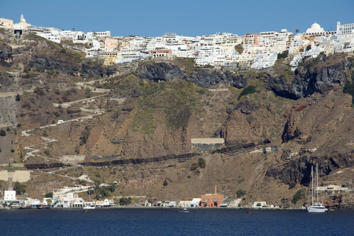
The ring of islands around the caldera sets the scene for a Santorini shore excursion. The caldera measures about 12 by 7 km, and cliffs 300 m high rise on three sides. Santorini, Therasia and Aspronisi stand on the rim, and the Kameni islands lie at the centre. Large cruise ships anchor in the small harbour between Nea Kameni and Fira, so passengers look up at the cliff wall from the water.
The setting also has scientific weight. The International Union of Geological Sciences placed the Quaternary Santorini Caldera among 100 geological heritage sites in a list published in October 2022. The caldera is one of the world’s sixteen Decade Volcanoes, and its walls, draped with whitewashed villages, draw volcanologists as well as visitors. A Santorini shore excursion therefore joins village stops with views of a volcano that scientists study.
The view from Fira runs from southern Cape Akrotiri to northern Cape Ag. Nikolaos, and Oia lies 11 km from Fira on the northern edge. An escorted excursion fixes the order of the stops and returns the passengers to the pier before the ship sails. A port-day Santorini shore excursion follows the departure of the ship, while a Santorini private tour is planned around a longer stay on the island.
- Setting: Santorini is the southernmost member of the Cyclades group, about 200 km southeast of the mainland.
- Capital: Fira holds the central bus station, and its routes cover almost all places around the island.
- Rock: The Kameni islands at the centre of the caldera are made of lava rock.
A Santorini shore excursion visits a landscape that the island itself protects. The pumice quarries have been closed since 1986 to preserve the caldera. Tourism is the primary industry of the island, particularly in the summer months, so a port day shares the villages and the roads with every other visitor.


How does a Santorini shore excursion get ashore?
A Santorini shore excursion gets ashore in two stages. Local boatmen tender the passengers from the anchored ship to Skala, the old port below Fira, and the cable car or the stepped path then lifts them up the cliff, while Athinios is the ferry port.
A Santorini shore excursion lands at Skala, one of the two ports of the island, while Athinios serves the ferries. Skala is also called Gialos, and its landing is known as Scala Pier. Cruise ships anchor off Skala, and local boatmen transfer the passengers to the shore. The lower station of the cable car serves the passengers who arrive by tender, so the pier and the lift stand together at the foot of the cliff.
The cable car is known locally as the Teleferico. It is a pulsed gondola lift that links the old port with Fira. An Austrian manufacturer built it to Austrian safety standards, and it has a capacity of 600 passengers per hour in each direction. On a Santorini shore excursion, the lift gives views of the Aegean Sea, the caldera, the volcano and the whitewashed buildings of Fira.
The stepped path is the third way up for a Santorini shore excursion. It zigzags from the port to Fira and has about 600 steps, and donkeys and mules climb it beside walkers. Animal rights organisations have criticised the use of donkeys for tourist transport, citing a failure to provide enough water or rest. Part of the cable car revenue supports the traditional mule drivers, and the rest is shared among the 14 communities of Santorini.
- Athinios: The ferry port lies 10 km south of Fira and links the island with Piraeus, the Cyclades, Crete and Rhodes.
- Fira square: The central square, Plateia Theotokopoulou, holds the bus and taxi station, banks and pharmacies.
- Funding: A donation from the Loula and Evangelos Nomikos Foundation paid for the lift.
A Santorini shore excursion therefore starts at the old port and not at the ferry port. The lift was built between 1980 and 1982 to replace the traditional ascent on foot or by mule. Fira is reached by road mainly on its eastern side, so the vehicle waits in the capital for the passengers who come up from the pier.
What does a Santorini shore excursion show in Oia?
A Santorini shore excursion shows Oia, the village at the northwestern tip of the island, with its cliff-top lanes, its captains’ houses and its view over the caldera. Oia lies 11 km from Fira, so the route follows the rim to the far end of the island.
Oia was known earlier as Apano Meria, which means upper side, and the name changed to Oia in the second half of the 19th century. The village stands on a hill and is called the Eagle’s Nest, because the Palia and Nea Kameni volcanoes and the island of Therasia are in view from it. A Santorini shore excursion reaches that view after the ride along the rim from Fira.
Oia reached its peak of prosperity in the late 19th and early 20th centuries. A merchant fleet traded across the Eastern Mediterranean, and in 1890 the village had about 2,500 residents. Wine from the hinterland was exported in quantity to France, among other places. Today a Santorini shore excursion sees the two-storey captains’ houses on the highest part of the village as a reminder of that wealth.
A Santorini shore excursion walks the narrow passageways of Oia, where houses and restaurants stand in niches carved into the caldera wall on the seaward side. Simple seamen’s houses cut into the edge of the caldera have become guest houses, hotels and restaurants. Kiosks sell handicrafts, jewellery and souvenirs, and small art galleries stand along the lanes. The main street, Nikolaou Nomikou, is cobbled.
- Castle: The ruined castle at the highest point gives a complete 360-degree view and was the seat of the Argyri family.
- Conservation: The Greek National Tourism Organisation preserved houses in Oia under Aris Konstantinidis and won the Europa Nostra Prize in 1979.
- Ground: The community works with geologists to map the geology, and its president restricted construction to limit earthquake risk.
The earthquake of 9 July 1956 damaged Oia, and the village redeveloped as a tourist town of the Cyclades. Its paths are very narrow and get congested in the tourist season. A Santorini shore excursion therefore shares the lanes on the lip of the volcanic crater with every other visitor.
Why does a Santorini shore excursion visit Akrotiri?
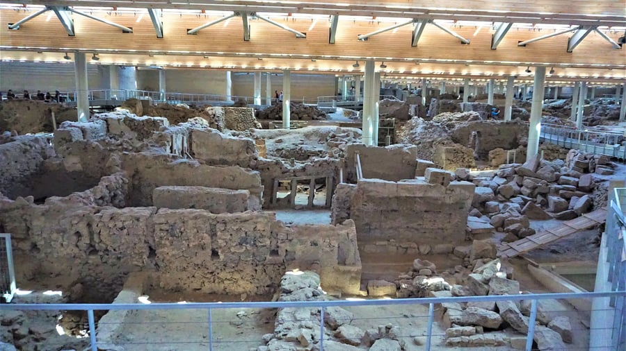
A Santorini shore excursion visits Akrotiri because the site is a Bronze Age town that volcanic ash buried and sealed. Wall paintings, tall buildings and drains survived under the ash, and a roof structure was built to protect the excavation.
The prehistoric town of Akrotiri belongs to the Cycladic Bronze Age and stands on the volcanic island of Santorini. Ash from the Theran eruption in the 16th century BC buried the town, and like the Roman ruins of Pompeii it is well preserved. The exact year is not known, but radiocarbon dating points to 1620 to 1530 BC. A Santorini shore excursion therefore reaches a town that the eruption ended abruptly.
The site that a Santorini shore excursion visits comes from an excavation that Spyridon Marinatos began in 1967, and the remains of the buried city appeared within hours. Two seasons, in 1967 and 1968, went into finding the extent of the town. A large share of the buildings stood higher than a single storey inside the ash. Marinatos experimented with tunnels through the pumice, and the method was later given up.
The ash layers record what came before the main eruption. A thin first layer of ash and the absence of winter erosion on it before the next layer arrived indicate months of warning for the local population. No human remains have been found at Akrotiri, and evidence suggests that survivors came back for their possessions. A Santorini shore excursion walks through a town that its people had left.
- First finds: The first fresco fragments, found in 1968 in Sector Alpha, show an African head, a blue monkey head and flying blue birds.
- Technique: The painters appear to have begun on wet plaster and finished on a dry surface, so the paint flakes off in places.
- Pottery: Pottery is abundant because the sudden evacuation let inhabitants take only their valuables, and finds include bathtubs, braziers and oil lamps.
A new roof structure meant to protect the site collapsed in 2005, just before its completion, and one visitor was killed. The antiquities were not damaged. The site stayed closed to visitors until April 2012, and excavations stopped from 2005 to 2016 for lack of funding. A Santorini shore excursion enters a site with that recent history.
Can a Santorini shore excursion include wine tasting?
A Santorini shore excursion can include wine tasting, because Santorini has its own small wine industry, which rests on the native Assyrtiko grape. Vines grow in low baskets on volcanic ash soil, and the island makes dry white wines and the sweet dessert wine Vinsanto.
The wine industry of Santorini is small. About 1,200 hectares are under vine, and tourism puts that land at risk of shrinking. Assyrtiko leads the plantings, beside Athiri, Aidani, Mavrotragano and Mandilaria. In the middle of the 19th century, the island exported all of its wine to Russia. A Santorini shore excursion with a tasting visits an industry with a long export record.
Growers train the vines in low spiralling baskets, called kouloura, with the grapes hanging inside to protect them from the winds. The vines stand far apart, because early-morning fog that condenses as dew is their main source of moisture. Islanders grew vines and olives without irrigation, since the island has no rivers and only one spring. A Santorini shore excursion through the vineyards shows vines at ground level.
A Santorini shore excursion tasting of Assyrtiko meets a grape whose acidity stays high even in very ripe fruit. Its wines are described as savoury, with stony minerality and citrus freshness, and Santorini examples are low-yielding and concentrated. Certain wine writers and sommeliers also cite their ageing potential. Labels carry the grape in other spellings as well, including Asyrtiko, Assirtico and Assyrtico.
- Soil: Ash in the ground contributes mineral notes and iodide salt aromas to the white wines.
- Vinsanto: Nuts, raisins, figs, honey and tea sit over the citrus and mineral aromas of the sweet wine.
- Name: Vinsanto means holy wine in Italian, and one theory ties the name to Venetian-era packages labelled Santo, with Vin marking the contents.
The method behind Vinsanto is among the oldest in winemaking. The Greek poet Hesiod described raisin wine making around 800 BC, and the sun-drying technique dates back to pre-Classical times. Greece and Cyprus are the original home of the style. A Santorini shore excursion with a Vinsanto tasting meets a style with that record.
Can a Santorini shore excursion visit the volcano?
A Santorini shore excursion can visit the volcano by boat from Skala, the old port. Tour boats sail across the flooded caldera to Nea Kameni, with a gravel trail up to its crater, and swimmers can reach Palea Kameni, which has a hot spring.
Skala is the old port of Santorini, and tour boats leave from it for Nea Kameni and other destinations. The anchorage of the large cruise ships is the small harbor between Fira and Nea Kameni, so the volcanic island lies across the water. Nea Kameni is an uninhabited island inside the flooded caldera. A Santorini shore excursion by boat reaches the lava directly from the port.
A Santorini shore excursion lands on Nea Kameni, which is nearly round, about 2 kilometres across, and covers 3.4 square kilometres. The crater rises 130 metres, and a gravel path climbs to its rim. Locals gave an active sulfur vent the name Jorgo, meaning George, in honour of King George I, since the vent was active the day after his visit to Santorini. Red succulents carpet the thin soil in summer.
Palea Kameni, the Old Burnt Island, is the smaller neighbour of Nea Kameni, on its southwest side. The lack of a good harbour keeps recreational watercraft away, and tourists swim across from Nea Kameni. The island holds a hot spring, and thermal waters in the caldera are warmer than the surrounding sea. A small church stands there, and goats live on the island.
- Cone: The Kameni islands are the latest cone built by this volcano, with much of each hidden beneath the water.
- Record: Nine eruptions above the sea are recorded since the first Kameni island broke the surface in 197 BC.
- Gas: Steam and carbon dioxide still escape from the active crater, and the island also holds former craters.
A short port-day crossing to the Kameni islands covers only the middle of a caldera that runs 18 kilometres from Cape Akrotiri to Cape Ag. Nikolaos. A full Santorini boat tour sails the wider water, including Therasia. The anchorage lies between Fira and Nea Kameni, so a Santorini shore excursion to the volcano crosses only the near side of the caldera.
Which villages and beaches does a Santorini shore excursion reach?
A Santorini shore excursion reaches the hill village of Pyrgos, the village of Megalochori and the village of Perissa with its beach. Pyrgos lies 7 km from Fira, Perissa lies 13 km away, and Megalochori counts among the 12 local subdivisions of Thira.
Pyrgos rises in tiers up a hill, like an amphitheatre, and a Santorini shore excursion looks out from it on nearly every side. The ruins of a Venetian castle, called Kasteli, stand on top, and the island was once administered from that castle. The medieval layout has labyrinthine lanes, fortified walls and hidden passages. The census of 2021 counted 1,078 residents, and the village ranks among those least spoiled by tourism.
Megalochori stands on Santorini, in the Cyclades island group. No river crosses the island, and a single spring serves it, so the Exo Gialos desalination plant supplies water to Megalochori. Its two units also serve Vourvoulou, Karteradou, Imerovigli, Pyrgos and Fira. Five other villages in Greece carry the name Megalochori: on Agkistri, on the Methana peninsula, on Lesbos, and in the regional units of Serres and Trikala.
The 2021 census recorded 725 permanent inhabitants in Perissa, a village near the Messa Vouno rock. Administratively, Perissa forms part of the Emporio community, together with Emporeio, Agios Georgios and Exomytis. Perissa keeps what is left of an Early Christian church dedicated to Saint Irene, and the name Santorini shortens that of the saint. The beaches of Perissa face the Aegean, and Perissa Beach itself is one of them.
- Older rock: Non-volcanic limestone and schist lie exposed at Pyrgos.
- Castle villages: Five kasteli stood on the island, Pyrgos among them, and Agia Theodosia, protector of castles, had a church at the gate of each.
- Tsunami of 1956: The tsunami after the 1956 earthquake is estimated to have reached 3 metres at Perissa.
The colour of the sand depends on which rock layer lies exposed, and the island has a Red Beach, a Black Beach and a White Beach. Lava soaks up heat, so the sea at the darker beaches runs warmer. Along the outer coast the beaches are smooth and shallow. Fira’s central station sends buses to nearly every place on the island.
When is the best season for a Santorini shore excursion?
A Santorini shore excursion in summer meets dry weather and the busiest tourist months, as tourism leads the economy of the island. Early spring and autumn fall outside the meltemi, the strong north wind of the Aegean summer, which blows until about mid-September.
Summers on Santorini are dry and winters are relatively wetter, a pattern that sits inside a hot semi-arid climate in the records of the National Observatory of Athens. The island receives about 270 mm of rain in a year and averages about 19 °C. By estimate, 2 million tourists come to Santorini each year. Tourism peaks in the summer months, so summer is the busiest period for any Santorini shore excursion.
Cruise passengers tendered to Scala Pier use the Old Port station of the cable car, and early or late rides avoid the crowds there. The very narrow paths of Oia get congested in the tourist season. Piraeus has a daily ferry link to the island all year. In summer, the direct crossings number up to 5, and charter flights join the scheduled ones.
The meltemi endangers sailors because it springs up in fine weather with no warning, and one spell can run for days non-stop. Once the wind reaches Beaufort force 7 or 8, not every inter-island ferry or yacht can put to sea. Over Santorini, in the southern Aegean, the meltemi arrives as a northwesterly. The boat transfer from an anchored ship to Skala crosses open water, the same sea that these winds cross.
- Clear skies: The meltemi brings fine, clear weather and tempers the fierce summer heat.
- Afternoon peak: The wind peaks in the afternoon and eases after dark.
- Oia wind: In October the wind at Oia reaches 98 km/h, against 56 km/h in August.
Early spring days fall before the meltemi starts, and autumn days fall after it ends. Winter is the wet season, and the lowest temperature on record at Oia is 0 °C, set in December. The hottest day on record at Oia reached 40 °C in June. A Santorini shore excursion in the months outside summer therefore meets neither the peak of tourism nor the meltemi.
What do travelers ask about a Santorini shore excursion?
A Santorini shore excursion by cruise ship starts when a boat lands passengers at Skala, the old port under Fira. Up on the caldera edge, Fira is reached from the port by cable car, by footpath, or by donkeys and mules.
How does the cable car carry passengers on a Santorini shore excursion?
A Santorini shore excursion rides a pulsed gondola lift that links the Old Port to Fira. A gondola carries six passengers, three to a row, and the lift climbs about 220 metres vertically. The upper station lies close to the Archaeological Museum, and builders completed the lift in 1982.
How steep is the climb on foot for a Santorini shore excursion?
A Santorini shore excursion on foot climbs about 600 steep steps from the port to Fira. The route follows a zigzag footpath, and donkeys and mules offer the other ride up. Animal rights organisations have criticised the use of donkeys for tourists, citing a failure to give the animals enough water or rest.
Does a Santorini shore excursion suit limited mobility?
A Santorini shore excursion suits limited mobility through the cable car, which is designed for passengers with mobility challenges, wheelchair users included. A wheelchair must not exceed 58 cm in width or 120 cm in length to fit a gondola. Advance coordination with the operator is recommended for smooth access.
Can a Santorini shore excursion include both Oia and Fira?
A Santorini shore excursion that joins Fira and Oia covers a distance of 11 km between the two. Buses depart very frequently from the capital’s central station, which serves as the transport terminus of the island. Oia also has a bus station of its own, on the northwest side of Santorini.
Which port does a Santorini shore excursion use?
A Santorini shore excursion by cruise ship uses the old port, Skala, while the ferry port is Athinios. Boatmen from the island carry passengers from the anchored ships to the shore at Skala. The anchorage lies between Fira and the volcanic island of Nea Kameni. Skala is the departure point of the tour boats that sail to Nea Kameni.
Featured photo: Zde, CC BY-SA 4.0, via Wikimedia Commons.