
A Crete boat trip sails from the harbours of the largest Greek island to its lagoons, islets and wild south coast, from Balos and Gramvousa in the west to Spinalonga in the east, Chrissi Island in the Libyan Sea, the coves below the White Mountains and the island of Dia off Heraklion. This post covers what a Crete boat trip includes, each of these routes, the best season and the FAQ. It is one of the boat trips in Greece on Greece VIP.
Each section ends with a Crete boat trip that can be booked online.
What does a Crete boat trip include?
Crete boat trip routes include coastal cruises, small-group sailings and crossings to the islets off the island. Crete has a coastline of 1,046 km, with the Sea of Crete to the north and the Libyan Sea to the south.
The island covers 8,336 km² and stretches 260 km from west to east. It is 60 km wide at its widest point and narrows to 12 km close to Ierapetra. The Cretan Sea lies to the north and covers 45,000 km², while the Libyan Sea, also called the South Cretan Sea, lies to the south.
A Crete boat trip reaches islets such as Gramvousa, Spinalonga, Chrissi, Dia and Gavdos, and passes the bays of Kissamos, Mirabello and Souda. Small boats leave from Chania, Kissamos, Heraklion, Ierapetra, Agios Nikolaos, Plaka and Chora Sfakion, and routes follow the coast or cross open water.
- Cretan Sea: Borders Crete to the north.
- Libyan Sea: Reaches 5,109 m depth.
- Islets: Uninhabited rocks sit offshore.
Vessels range from small boats to larger ferries, and each route suits a different part of the coast. A Crete boat trip in the west follows sheltered bays, while eastern and southern routes face open water. Departure points run from Chania to Ierapetra, so travelers pick the coast that fits the day.


Which Crete boat trip sails to Balos and Gramvousa?
Crete boat trip services to Balos and Gramvousa leave from Kissamos and cross to the lagoon and the islet beyond it. Imeri Gramvousa holds a Venetian fort, and Balos lagoon lies between the island and the Cretan coast.
The fort on Imeri Gramvousa was built between 1579 and 1584 to defend Crete. Venice kept Gramvousa, Souda and Spinalonga after the treaty of 16 September 1669, and the fort passed to the Ottomans in 1691. Kissamos, also called Kastelli Kissamou, is the westernmost town of the Chania regional unit.
A Crete boat trip here enters a protected area. The Region of Crete lists the Gramvousa peninsula, the islands of Imeri and Agria Gramvousa and the islet of Pontikonisi as Natura 2000 sites. Sand dunes sit beside the lagoon at Balos. The lagoon formed after an earthquake in 365 AD.
- Balos lagoon: Sits beside Cape Tigani.
- Imeri Gramvousa: Holds fort ruins.
- Kissamos: Serves the northwest coast.
A Crete boat trip to this coast ends where the peninsula meets cliffs and sea caves. A Balos lagoon cruise combines a crossing with a walk to the fort. Visitors land at the lagoon or at the islet, depending on the route and the wind. Weather shapes each landing there.
Which Crete boat trip reaches Spinalonga?
Crete boat trip routes to Spinalonga cross the Gulf of Elounda to a rocky island of 85,000 square metres. Spinalonga held a Venetian fortress and later a leper colony, and it has been uninhabited since 1962. It ranks second among visitor sites in Crete.
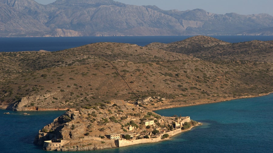
The leper colony operated from 1904 to 1957, and the island was called the island of the living dead. Around 750 m of water separates Spinalonga from the village of Plaka, where boats for a Crete boat trip wait for visitors. Elounda, a town of 2,254 residents in the 2021 census, lies nearby.
A Crete boat trip in this gulf passes Mirabello Bay, the largest bay of the Greek islands and the fifth largest in the Mediterranean, and Agios Nikolaos overlooks it. Spinalonga sits at the northern mouth of the gulf, with Kolokytha island to the south. The fortifications were built under Venetian rule, and the walls face the open Sea of Crete.
- Fortress: Venetian walls ring it.
- Plaka: A village facing the island.
- Elounda: The main departure point.
Boats to Spinalonga leave from Plaka, Elounda and Agios Nikolaos. A Spinalonga tour suits travelers who want history and a short crossing, since the island sits close to the shore. The fortifications and the ruined houses show the Venetian and later periods. The crossing stays short, calm and brief.
Which Crete boat trip sails to Chrissi Island?
Crete boat trip services to Chrissi Island leave from Ierapetra and cross the Libyan Sea to a protected islet 15 km south of Crete. Chrissi carries the largest naturally formed juniper forest in Europe, with trees averaging 200 years.
A Crete boat trip here lands beside a forest of Juniperus macrocarpa, and the trees reach 10 m in height, with a density of 28 trees per hectare. Chrissi is protected as an area of intense natural beauty and forms part of the Natura 2000 network.
A Crete boat trip from Ierapetra also passes Mikronisi, an islet 700 m east of Chrissi. Ierapetra is the largest town in the Lasithi regional unit, with 17,710 residents in the 2021 census, and it serves as the main Greek port on the Libyan Sea. The shallow water around Chrissi suits snorkelling.
- Juniper forest: Junipers cover the islet.
- Ierapetra: The main departure harbour.
- Mikronisi: A smaller islet to the east.
Crossings to Chrissi run from Ierapetra from spring until late October. A Chrissi Island cruise gives time on the coast and in the shallow bays. The chapel of Saint Nicholas, the old port and the Minoan ruins show why the islet holds protected status.
Which Crete boat trip leaves from Chania?
Crete boat trip departures from Chania sail past the Venetian harbour and the lighthouse at its entrance, then follow the Akrotiri coast. The lighthouse was built in 1864 and stands 26 m tall, flashing red every 2.5 seconds.
A Crete boat trip along this shore passes the Agioi Theodoroi islets, where kri-kri, the Cretan goat, lives. Agios Theodoros, also called Thodorou, is uninhabited and holds two small Venetian fortresses from 1583. The islets form an Important Bird Area, with 50 to 65 breeding pairs of Eleonora’s falcon, and the highest point reaches 165 m.
The kri-kri population on Thodorou began in 1935, when one male and two females were caught in the Samaria Gorge and released. The species lives on Crete and on three small islands off its coast, and about 2,000 animals remain. The Akrotiri peninsula covers 112 km² and holds three monasteries.
- Harbour: A Venetian harbour and lighthouse.
- Thodorou: An islet with goats.
- Akrotiri: A peninsula east of Chania.
A Chania boat trip leaves from a harbour that has served shipping since the Venetian period. The old town, the lighthouse and the nearby islets sit within a short distance of the quay. Routes along the Akrotiri coast suit travelers who want a calm crossing close to shore. The harbour opens onto the Sea of Crete.
Which Crete boat trip explores the south coast?
Crete boat trip routes on the south coast link Chora Sfakion, Loutro and Agia Roumeli, the village at the exit of the Samaria Gorge. Ferries also run to Gavdos, the southernmost Greek island, which lies 26 nautical miles from Chora Sfakion.
The coastal villages of Sfakia are not connected by a coastal road, so boats carry passengers between them. Loutro stands on the site of ancient Phoenix, which served as a harbour in Hellenistic and Roman times, and the village is car-free. Agia Roumeli sits at the end of a 16 km path from the gorge.
A Crete boat trip to Gavdos crosses open water to an island of 32 km² with 142 residents. Gavdos and its neighbour Gavdopoula are Important Bird Areas, and the highest point, Mount Vardia, reaches 345 m. The Samaria Gorge has been a national park since 1962 and forms part of a UNESCO Biosphere Reserve.
- Sfakia: Villages reached by ferry.
- Loutro: A car-free village.
- Gavdos: The southernmost Greek island.
A Crete boat trip on the south coast replaces road travel, since the mountains drop straight to the Libyan Sea. Ferries connect the villages in a chain that runs from Chora Sfakion eastward and westward. Walkers finish the gorge at Agia Roumeli and continue by boat. Swimmers use the quiet beaches between the villages.
Which Crete boat trip reaches Santorini or Dia?
Crete boat trip routes to Santorini use a fast ferry from Heraklion for a day on the Cyclades island, while a shorter crossing from Heraklion reaches Dia, an uninhabited islet 13 km north of the city, with four coves on its south coast.
Dia covers 11.9 km², measures 5 km by 3 km and rises to 220 m. It served as the principal port of Crete for centuries, and its coves served as anchorages in the Minoan period. Eleonora’s falcon breeds there in 300 to 380 pairs, and the islet forms part of the Natura 2000 network.
A Crete boat trip to Santorini crosses the Sea of Crete, since the island lies in the southern Aegean about 200 km southeast of the Greek mainland. Santorini has 15,480 residents and covers 73 km², and the municipality includes Therasia and the uninhabited islets of Nea Kameni, Palaia Kameni and Aspronisi.
- Dia: A short crossing from Heraklion.
- Santorini: A day route across the sea.
- Heraklion: The departure port for both.
A Crete boat trip that aims at Santorini covers a longer distance and suits an early start. Dia lies much closer, and the crossing leaves time for swimming and walking on the beach. Heraklion, with 179,302 residents in its municipality, is the largest city on the island and the main ferry hub.
Which wildlife does a Crete boat trip see?
A Crete boat trip passes waters that hold dolphins, loggerhead sea turtles, Mediterranean monk seals, Eleonora’s falcons on the islets and Posidonia sea-grass meadows. Every animal in this list is wild, so each sighting depends on the day and the route.
The seas around Crete are rich in large marine mammals. South of the island lies the Greek Abyss, an area that hosts whales, sperm whales, dolphins and porpoises. Minoan frescoes in the Queen’s Megaron at Knossos show dolphins. Squid, octopus and hammerhead sharks also live or pass along the coast. A Crete boat trip on the south coast sails on the sea beside this deep area.
Sea turtles along Crete include the green turtle and the loggerhead, and both are threatened species. The loggerhead nests and hatches on north-coast beaches around Rethymno and Chania and on south-coast beaches along the gulf of Mesara. Its name refers to its large head, and its powerful jaws crush bottom-dwelling prey such as whelks and conchs. A Crete boat trip meets loggerheads in open water and shallow coastal water, away from the nesting sand.
The Mediterranean monk seal is endangered and is believed to be the rarest seal species in the world. Adults average 2.4 metres in length, and males average 320 kilograms. Seals once gathered on open beaches and now use sea caves, and the caves frequently have underwater entries. Shy by nature, the seals avoid contact with people, so a sighting from a Crete boat trip depends on luck.
- Eleonora’s falcon: Two-thirds of the world population breeds off Greece.
- Posidonia meadows: Neptune grass grows only in the Mediterranean, at depths of 1 to 35 metres.
- Clean water: Posidonia grows best in clean waters, which marks a lack of pollution.
The falcon breeds late in summer, because it hunts the migrating birds that pass the Mediterranean islands then. Posidonia takes its name from Poseidon, and a new leaf needs about 51 days to grow. A Crete boat trip passes both settings, the meadows below the hull and the coastal cliffs where falcons nest.
When is the best season for a Crete boat trip?
Crete boat trip weather fits the warm season, when the meltemi wind and calm water shape each crossing. The meltemi blows from late spring to mid-September, and the Samaria national park admits visitors from spring until the end of October.
Crete has a hot-summer Mediterranean climate, and the south and east of the island are semi-arid. Higher ground falls into a colder Mediterranean category, and the peaks above 2,000 m carry a continental climate. Snow lies on the mountains between November and April, while winters at the coast stay mild. Agios Nikolaos records a mean daily maximum of 31.6 °C in August.
The etesian winds, called meltemia in Greek, blow from the north across the Aegean and reach force 7 to 8 on the Beaufort scale. They are strongest in the afternoon and calm at night, and they blow as northwesterlies over the Cretan Sea. A Crete boat trip in the southern Aegean faces these winds.
- Meltemi: North winds in warm months.
- Summer: Hot days with afternoon wind.
- Spring and autumn: Cooler, quieter seas.
A Crete boat trip works best when the wind allows a crossing and the sea stays calm. Mornings are quieter, since the meltemi builds through the day. Spring and autumn bring lower air temperatures and lighter winds, while the mountain snows melt and the gorges carry water to the coast.
What do travelers ask about a Crete boat trip?
Crete boat trip questions cover routes, ports, wildlife and weather. The answers below cover the crossings that leave from Cretan harbours, the islets that lie offshore, and the months when the wind and the sea allow comfortable sailing.
Can a Crete boat trip reach an uninhabited island?
A Crete boat trip can reach Chrissi, Dia, Gavdos, Gramvousa and Spinalonga, and none of these islands has a permanent population except Gavdos. Chrissi and Dia hold protected status. Landings depend on the route and the weather on the day.
Which Crete boat trip suits families with children?
Short crossings to Plaka and Spinalonga, to Dia or to the lagoon at Balos suit families, because the boats stay close to the coast and the water is shallow. A Crete boat trip with children works best in the morning.
Is a Crete boat trip possible in spring?
Spring crossings begin when the park season opens, and the meltemi arrives in the weeks that follow. Air temperatures at the coast are lower than in high summer, and the gorges carry meltwater from the mountains. Boats run on fine days, but the wind decides the route.
What do travelers need for a Crete boat trip?
Travelers need sun protection, water, footwear for rocky ground and a light jacket for the crossing. Islets such as Chrissi have no fresh drinking water and no shade, and the sun on the water is strong. A hat and a long-sleeved shirt help on open boats.
Do boats for a Crete boat trip leave in strong wind?
Strong meltemi wind keeps small boats in harbour and makes open crossings rough, so operators change routes or cancel departures. Sheltered water in Mirabello Bay and the Gulf of Elounda stays calmer than the open sea, and morning departures avoid the strongest wind.
Featured photo: Maesi64, CC0, via Wikimedia Commons.