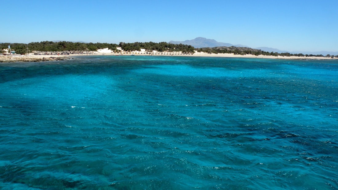
A Chrissi island cruise sails from the south-east coast of Crete to Chrissi, an uninhabited and protected island in the Libyan Sea south of Ierapetra, known for its old juniper trees, its white dunes and its clear water. This post covers what a Chrissi island cruise includes, where the boats leave from, the juniper forest, the beaches, the history of the island, the protection rules, the crossing of the Libyan Sea and the best season. It is one of the best tours in Greece on Greece VIP.
Each section ends with a Chrissi island cruise that can be booked online.
What does a Chrissi island cruise include?
A Chrissi island cruise is a boat trip from the south coast of Crete to Chrissi, an uninhabited and protected island in the Libyan Sea. The cruise crosses open water, lands on white beaches, and ends with the return to Crete.
Chrissi is an uninhabited Greek island in the Libyan Sea, south of Crete. Its Greek name, Chrysi, means golden, and the island also carries the name Gaidouronisi, which means donkey island. It lies about 12 kilometres off the coast of Ierapetra, in the region of Lasithi. A Chrissi island cruise therefore visits a place with no residents and no fresh drinking water.
The island measures about 5 kilometres in length and 1 kilometre in width on average. Its surface stands 10 metres above sea level on average, and the island is known for white beaches and sand dunes. It is protected as an area of intense natural beauty. Camping is forbidden, so a Chrissi island cruise always takes the form of a day trip.
Two kinds of Chrissi island cruise exist: the excursion boat from the quay of Ierapetra and the sea route from Myrtos. The shallow waters around Chrissi make snorkelling and diving popular pastimes on both. Boat trips of the north coast of Lasithi, such as the Spinalonga tour, belong to a different shoreline, because Ierapetra lies south of Agios Nikolaos and faces the Libyan Sea.
- Landmarks: The island holds a small harbour, a salt pan, an old port and a lighthouse.
- Church: The Church of Saint Nicholas stands on the northwestern coast.
- Neighbour: The islet of Mikronisi lies 700 metres east of Chrissi.
The Libyan Sea is the part of the Mediterranean Sea that separates Crete from North Africa. The municipal unit of Ierapetra consists of the town, its villages and the island of Chrissi. A Chrissi island cruise therefore crosses open water to an island that belongs to a Cretan municipality but has no residents.


Where does a Chrissi island cruise leave from?
A Chrissi island cruise leaves from the harbour of Ierapetra, the only town on the southern coast of Crete and the main port of Greece in the Libyan Sea. Visitors based east of town, around Makry Gialos, reach the quay by the coast road.
Ierapetra is the fourth largest city of Crete and the largest in the Lasithi regional unit. The town had 17,710 inhabitants in 2021, and its nickname is the bride of the Libyan Sea. The centre divides into Kato Mera, the old town on the southwestern headland, and Pano Mera, the larger new town with wider streets, which is still expanding.
The quay for the ferries of a Chrissi island cruise lies east of a short beach with bars and restaurants. West of that beach, the southern headland holds the fortress and a port for fishing boats. The Fortress of Kales, built in the early years of Venetian rule, protects the harbour. Beyond the quay, the main boulevard holds hotels, bars, restaurants and souvenir shops.
Makry Gialos is a former municipality on the south-east coast of Crete. Its villages stand along the coastal road between Sitia and Ierapetra, and the old seat of the municipality, Koutsouras, lies 22 kilometres east of Ierapetra. That road links the Makry Gialos coast to the quay of every Chrissi island cruise, so the coast to the east forms a base for the trip.
- From Ierapetra: Sitia airport lies 59 kilometres away, Heraklion airport 94 kilometres.
- From Makry Gialos: Sitia airport lies 33 kilometres away, Heraklion airport 121 kilometres.
- Lookout: The summit of Afendis Stavromenos, 1,500 metres high, overlooks Chrissi and Koufonisi, depending on visibility.
The municipality of Ierapetra formed in the 2011 reform through the merger of Makry Gialos and Ierapetra. In 2012, Ierapetra won the Gold QualityCoast award and ranked second among the Top 100 European destinations. The notable beaches of the area include the Golden Coast of Chrysi Island, the shore of a Chrissi island cruise.
Why is the cedar forest special on a Chrissi island cruise?
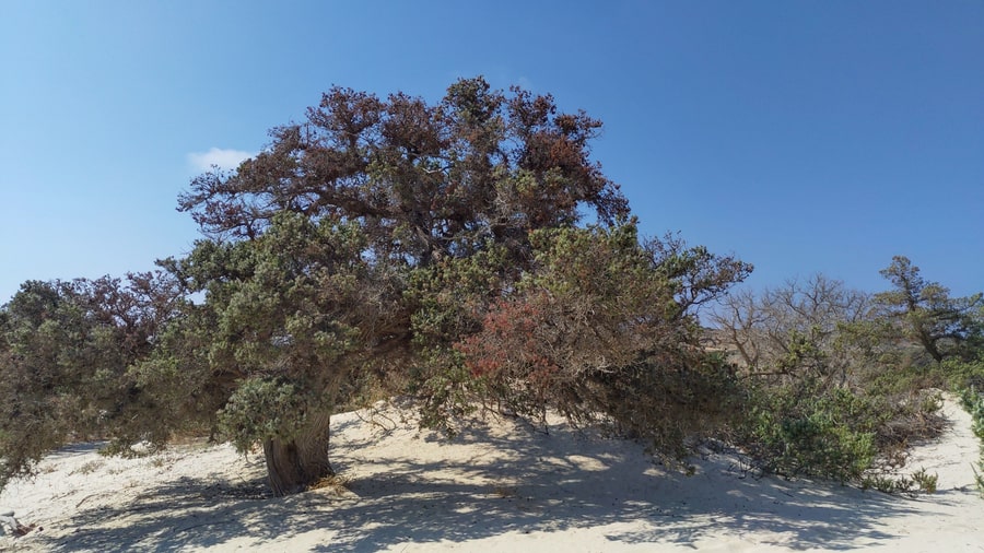
A Chrissi island cruise reaches the largest naturally formed forest of Juniperus macrocarpa in Europe, a juniper woodland called a cedar forest. Its trees average 200 years in age, and the island is protected as an area of intense natural beauty.
Juniperus macrocarpa is the large-fruited juniper. The species is native across the northern Mediterranean region, from southwestern Spain east to western Turkey and Cyprus. It grows on coastal sand dunes from sea level up to 75 metres in altitude. Chrissi suits that setting, because the highest point of the island, Kefala, stands only 31 metres above sea level, well inside that limit.
Elsewhere the species grows as a spreading shrub 2 to 5 metres tall, and a tree of 14 metres is rare. The trees of Chrissi reach an average height of up to 7 metres, so a Chrissi island cruise shows trees well above the shrub size of the species. The density of the forest is about 28 trees per hectare.
Age marks the forest as a long-standing part of the island. The majority of the trees have an average age of 200 years. The oldest trees are 300 years old and 10 metres tall. The island is also known for a forest of pines and junipers beside its white beaches, so the cedar forest forms one part of a wider woodland.
- Cones: The berry-like cones ripen from green to orange-red in 18 months.
- Seeds: Birds eat the cones and spread the hard seeds in their droppings.
- Genetics: Genetic studies show its DNA is distinct from that of Juniperus oxycedrus.
Visitors are not allowed to roam freely over the island, only on designated paths and on beaches close to the eastern tip. A Chrissi island cruise therefore keeps to those paths while the forest stays protected. The protection applies to the whole island, so the cedar forest, the dunes and the beaches fall under the same status.
Which beaches does a Chrissi island cruise reach?
A Chrissi island cruise reaches the white sand beaches of an uninhabited island about 15 kilometres south of Crete in the Libyan Sea. Belegrina, Hatzivolakas and Kataprosopo are the three named bays, and each holds a wide diversity of shells.
The island measures about five kilometres in length and one kilometre in average width. It sits at an average of ten metres above sea level, so the land is low. Descriptions of the island name white beaches and sand dunes as the best-known features. A Chrissi island cruise therefore arrives at a low strip of sand in the open Libyan Sea.
The Greek national Natura record describes the sand beaches of the island as laid with small shells. It counts this among the extraordinary features of the site, and it calls the site a rare combination of ecosystems. Passengers on a Chrissi island cruise who walk along the three named bays see a shoreline where shells and sand share the same ground.
Owing to the shallow water around the island, snorkelling and diving are popular pastimes there. The Greek record also lists shallow gulfs, and it gives the length of the coast as 14.2 kilometres. The sand beaches laid with shells sit beside these gulfs. A Chrissi island cruise therefore reaches a stretch of the Libyan Sea where shallow water meets the sand.
- North coast: A nudist beach lies on the north coast of the island.
- Eastern tip: Visitors are limited to the beaches close to the eastern tip.
- Name: Chrysi means golden in Greek.
Mikronisi is a rocky and over-grazed islet 700 metres east of Chrissi, and it forms a separate island from the beaches described here. A Chrissi island cruise therefore centres on Chrissi itself: a compact island with a long edge of sand and shells, and a short list of beaches that visitors can use.
What history lies behind a Chrissi island cruise?
A Chrissi island cruise visits an uninhabited island in the Libyan Sea where archaeologists excavated a Minoan settlement dated between 1800 and 1500 B.C. Excavators found purple dye workshops there, and a 13th-century chapel of Agios Nikolaos marks a later period.
A Ministry of Culture report describes a trial excavation on the islet. The dig reached parts of five houses, out of the ten to twelve estimated to make up the settlement. The architecture belongs mainly to the Late Minoan IB period, and the report finds signs of habitation from the Early Minoan I and II periods. A Chrissi island cruise therefore reaches a site with a long record of use.
Besides household pottery, the houses gave finds of unexpected quality and quantity, which the report reads as a rich settlement. On the first evidence, the report suggests a possible link between that wealth and the processing of purple. Regional descriptions name fishing, salt export and the export of porphyra as the sources of wealth. Porphyra is a scarlet dye made from shells, also known as Tyrian purple.
After the collapse of the Byzantine Empire, the island was abandoned, although it was later used as a hideout. A Roman cemetery marks an earlier use of the island, in Roman times. The island is uninhabited today, and a Chrissi island cruise reaches a place whose past settlement survives only as ruins and chapels, with no village standing on the shore.
- Salt pan: The island holds a salt pan.
- Old port: An old port is listed among the remains.
- Lighthouse: A lighthouse stands on the island.
The Church of Saint Nicholas stands on the north-western coast beside a small harbour. The chapel of Saint Nicholas in the west is estimated to date to the 13th century, and a Byzantine chapel of Agios Nikolaos is placed at the western tip. These buildings mark the later centuries, after the Minoan period that a Chrissi island cruise also recalls.
How is the island protected on a Chrissi island cruise?
A Chrissi island cruise visits an island protected as an area of intense natural beauty, and the Greek national database files it as a Natura site under code GR4320003. Camping is forbidden there, so only day trips are possible.
The Greek national Natura record uses a matching label for the island and calls the island a special natural beauty site. The record places the site in the prefecture of Lasithi and gives the total area as 546.54 hectares, of which 485.22 hectares are land. A Chrissi island cruise therefore calls at a single site that Greece records as a protected natural area.
Natura 2000 is a network of nature protection areas in the European Union. It is made up of Special Areas of Conservation and Special Protection Areas, set up under the Habitats Directive and the Birds Directive. Sites in the network are not strictly protected in terms of how people use them. Each site has a standard data form that serves as a legal reference.
The characteristic plant cover of the sand dunes is a juniper matorral of Juniperus macrocarpa. Chrysi is one of the rare sites in Greece where this maquis grows on sand dunes. The Greek record states that free camping destroys the roots and the branches of both juniper species, and that tourism expansion threatens the island. The plants that cover the dunes are the plants that camping damages.
- Paths: Visitors are not allowed to roam freely and stay on designated paths.
- Shells: The record notes that tourists remove dead shells by hundreds.
- Plants: Silene ammophila is protected by Greek law and is listed as a threatened plant.
The Greek record lists the Mediterranean monk seal and the loggerhead turtle among the notable animals of the site. It adds that Periploca angustifolia grows only on Chrysi and Gavdos in Greece. The island has no fresh drinking water. These species share the island with day visitors on a Chrissi island cruise, who stay on the paths and do not camp.
What does the Libyan Sea crossing show on a Chrissi island cruise?
A Chrissi island cruise crosses the Libyan Sea, the part of the Mediterranean that lies south of Crete. Passengers leave the bay of Ierapetra, watch the southern coast of Lasithi fall behind the stern, and approach a low, uninhabited island.
The Libyan Sea has an old name. Ancient geographers used it for the part of the Mediterranean south of Crete, between Cyrene and Alexandria. In recent years the stretch south of Crete has also been called the South Cretan Sea. A Chrissi island cruise therefore sails through waters that ancient geographers already named. Beyond Crete itself, the sea holds four islands: Gavdos, Gavdopoula, Koufonisi and Chrysi.
Ierapetra sits on the southeast coast of Crete and serves as the main Greek port in the Libyan Sea. Its nickname, the bride of the Libyan Sea, refers to its position as the only town on the southern coast. A promenade runs beside the long beach of Ierapetra Bay, and the shallow bay still holds the remains of the Roman harbour of ancient Hierapytna.
Lasithi is the easternmost regional unit of Crete, to the east of Heraklion. The Sea of Crete lies to its north and the Libyan Sea to its south. Villages such as Myrtos, Makrigialos, Xerokambos and Koutsouras line the south coast. Between Ierapetra and Neos Myrtos, plastic greenhouses cover an area of 15 square kilometres, so farmland shares the coast with the beaches.
- Fortress of Kales: Francesco Morosini strengthened the fortress in 1626 to protect the harbour.
- Municipality: Chrissi belongs to the municipality of Ierapetra in Lasithi.
- Asterousia coast: The Libyan Sea also borders the Asterousia Mountains and the Mesara Plain.
A Chrissi island cruise therefore shows three parts of the south: the open Libyan Sea, the bay and port of Ierapetra, and the Lasithi coast with its villages and farmland. Chrissi itself averages 10 metres above sea level and peaks at 31 metres on Kefala, so the island lies low on the horizon.
When is the best season for a Chrissi island cruise?
A Chrissi island cruise runs from late spring until late October, the period when boats reach the island from Ierapetra. Ierapetra has hot, dry summers and mild, rainy winters, and the summer etesian winds of the Aegean end in mid-September.
Ierapetra has a hot-summer Mediterranean climate, with hot, dry summers and mild, rainy winters. The average annual temperature for the period from 1956 to 2010 was 19.9 degrees Celsius. The town gets over 3,100 hours of sunshine per year and shares the title of Greece’s sunniest area with Rhodes. A Chrissi island cruise therefore starts from one of the sunniest places in the country.
The etesians are the strong, dry north winds of the Aegean Sea. They are strongest in the afternoon and sometimes last for days without a break. In the Cretan sea they blow as northwesterlies. They come up in clear weather without warning and can reach force 7 to 8 on the Beaufort scale, a strength at which certain yachts and inter-island ferries cannot sail.
Lasithi has a mild climate year-round, and Ierapetra has mild, rainy winters. Even so, boats reach Chrissi only between late spring and late October. Spring and autumn therefore mark the two edges of the season, when boats make the first and last crossings. Local life follows the same calendar: the main economic activities of the Ierapetra area are agriculture in winter and tourism in summer.
- Summer heat: The northerly etesians temper the fierce summer heat of the region.
- Wind name: The word etesian comes from the Greek word etos, meaning year.
- Sailing wind: Leisure sailors favour the steady wind that the etesians provide.
A Chrissi island cruise therefore suits the long, dry season from late spring to late October. The etesian winds end in mid-September, while the boats keep sailing until late October. A traveler who wants to avoid the etesian period picks a date between mid-September and late October. Summer itself remains the period of hot, dry weather.
What do travelers ask about a Chrissi island cruise?
A Chrissi island cruise raises practical questions about shade, supplies, children, overnight stays and swimming. The answers below rely on published facts about the island, which is uninhabited, protected as an area of intense natural beauty and visited by day only.
Is there shade on a Chrissi island cruise?
Shade on a Chrissi island cruise comes from the juniper forest, the largest naturally formed Juniperus macrocarpa forest in Europe, where trees average up to 7 metres in height. Visitors cannot roam freely, though, so access to the trees follows designated paths.
What do passengers bring on a Chrissi island cruise?
The island has no fresh drinking water, so passengers carry their own. The area is among the sunniest in Greece, which makes sun cream and a hat practical items. Snorkelling and diving are popular pastimes because the waters around Chrissi are shallow, so a mask is also useful.
Can children join a Chrissi island cruise?
The published description of Chrissi lists no age limit. It does give the size of the island, which is 5 km long and on average one kilometre wide. A family planning a Chrissi island cruise confirms any age rule with the boat before the day.
Can visitors stay overnight on a Chrissi island cruise?
Camping is forbidden on the island, so only day trips are possible. Chrissi is uninhabited, and the structures on it include a small harbour, a church, a lighthouse and an old port. Visitors therefore return to the mainland the same day after a Chrissi island cruise.
Is swimming possible on a Chrissi island cruise?
The beaches close to the eastern tip are open to visitors, so swimming takes place on those beaches. The island is known for white beaches and sand dunes, and the bays of Belegrina, Hatzivolakas and Kataprosopo hold a wide diversity of shells.
Featured photo: Kris Van Achter, CC BY-SA 3.0, via Wikimedia Commons.