A Chania boat trip leaves the Venetian harbour of Chania, or one of the small ports of the Chania regional unit, for the islets, peninsulas and coves of north-west and south-west Crete. This post covers what a Chania boat trip includes, the Venetian harbour from the sea, Agioi Theodoroi, the Akrotiri peninsula and Souda Bay, the south coast villages, the boats, the far west coast and the best season. It is one of the tours in Greece on Greece VIP.
Each section ends with a Chania boat trip that can be booked online.
What does a Chania boat trip include?
A Chania boat trip is an outing by sea from the city or its coast on north-west Crete. Four kinds of boat serve it: glass-bottom boats, sailing boats, private boats and ferries on the southern coast of the regional unit.
Chania faces the sea at north-western Crete, with Rethymno 70 km away to the east and Heraklion 145 km away. The municipality forms the eastern shore of Chania Bay, and the old town lies by the old harbour. A Chania boat trip begins at the water’s edge of a city that the Venetians founded as Canea in 1252, where the ancient city of Kydonia once stood.
The sea forms the northern border of the old town, and three neighbouring municipalities frame the municipality of Chania. Platanias lies to the west, Apokoronas to the east and Sfakia to the south. The islets of Agioi Theodoroi belong to Platanias, so a Chania boat trip to them heads west along the shore of Chania Bay, away from the old harbour.
The ports around the city differ in role. Souda, 7 km east of Chania, is the city’s port, with daily ferries to Piraeus, and it also hosts Crete Naval Base. Kissamos port lies 41 km to the west of Chania. The Balos lagoon cruise is a day cruise from Kissamos, which sets it apart from a Chania boat trip that leaves from Chania itself.
- Glass-bottom boats: A window in the hull shows the sea floor.
- Sailing boats: The wind sets the pace along the shore.
- Private boats: The party that hires the boat sets the route.
- South coast ferries: The ferries serve Sfakia on the south shore.
The Venetian harbour comes first on a Chania boat trip, because the old town, the lighthouse and the fortress stand beside it. The islets of Agioi Theodoroi come next, in Platanias to the west. The two stops show the city as the Venetians planned its defence and the coast that they guarded.


What does a Chania boat trip see from the Venetian harbour?
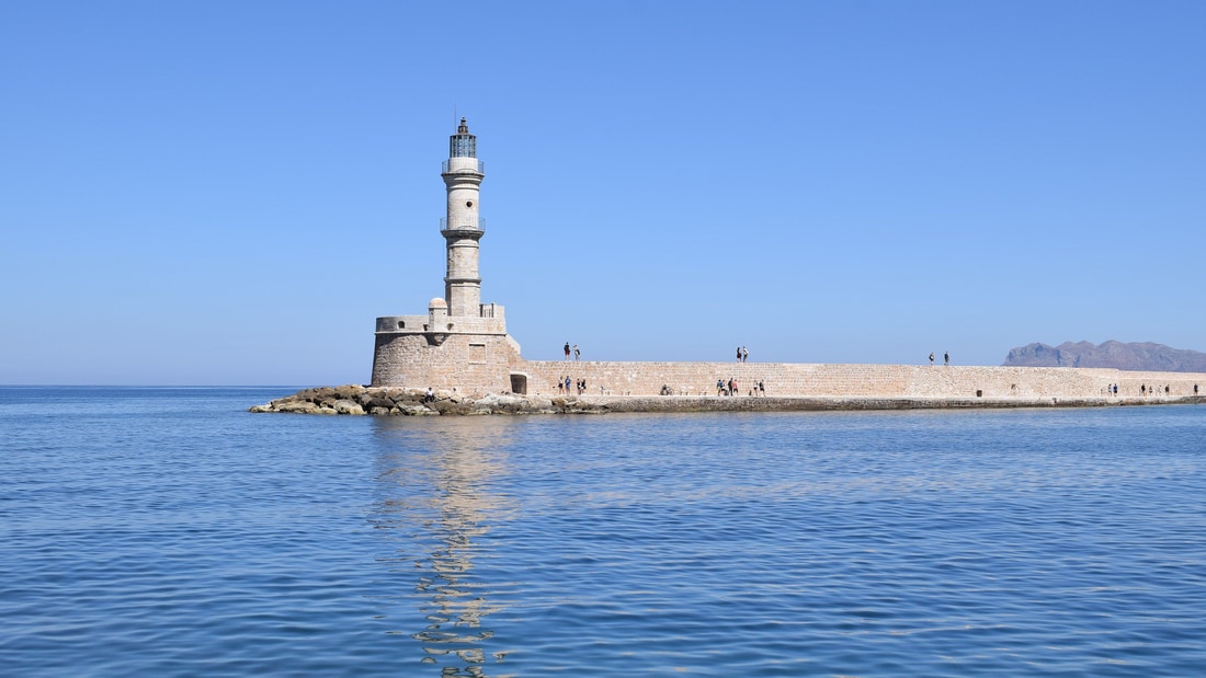
A Chania boat trip sees the old Venetian harbour with the lighthouse at its entrance, Firkas Fortress and the Küçük Hasan Pasha Mosque on the waterfront. The old town stands beside the quays. Venetian, Ottoman and Greek history sit side by side.
The sea closes off the old town of Chania to the north, and the old harbour lies at its edge. Historic buildings and nightlife line the quays along the water. The Küçük Hasan Pasha Mosque, also called the Yali Mosque, is one of the mosques that the Ottomans built on the harbour. From the water, a Chania boat trip takes in the whole waterfront.
Chania Lighthouse marks the mouth of the port. The Venetians set a naval post on the site against Turks and pirates. After the Ottoman capture of 1645 the post fell into ruin, and Egyptian troops rebuilt the lighthouse in 1864, so only the base of the Venetian original survives. A Chania boat trip passes the 26-metre stone tower on the way out.
Venetian builders raised Firkas Fortress in 1620 as a guard for the harbour. It stands close to the San Salvatore Bastion on the north-west corner of the Venetian walls, which went up between 1536 and 1568. The union of Crete with Greece was celebrated at the fortress on 1 December 1913, and the Greek flag was raised there for the first time.
- Quays: Akti Enoseos holds the marina, beside Akti Tompazi and Akti Kountouriotou.
- Lighthouse: A listed archaeological monument of Greece since 1962.
- Firkas Fortress: A harbour fort of 1620 beside the old walls.
From the harbour mouth, a Chania boat trip reads the city as layers laid along one shore. The Venetians built the fort and the first naval post, the Ottomans added the mosque, and Egyptian troops rebuilt the tower. Each layer faces the water, and the boat shows all of them in a single pass.
Why does a Chania boat trip sail to Agioi Theodoroi?
A Chania boat trip sails to Agioi Theodoroi because the two uninhabited islets off western Crete shelter protected kri-kri, the Cretan goat, and two small Venetian fortresses built in 1583. The islets lie in the municipality of Platanias, in the Chania regional unit.
Agioi Theodoroi lie off the coast of western Crete, west of the city of Chania and its harbour. One islet is Agios Theodoros, also called Thodorou. The islet just north of it is Mikros Agios Theodoros, meaning Little Agios Theodoros. In antiquity the islets carried the names Coete and Akytos, and the Stadiasmus Maris Magni of the third century records drinkable water on them.
Kri-kri inhabit Agios Theodoros. The animal has a light brownish coat with a darker band round its neck and two horns that sweep back from its head. In the wild it is shy, avoids people and rests by day. Today the species lives only in Greece, on Crete and on three small islands off its coast: Dia, Thodorou and Agii Pantes. Hunting kri-kri is strictly prohibited.
In 1583 the Venetians built two small fortresses on Agios Theodoros, to stop pirates using the islands and to defend the coast of Crete. They had finished the walls of Chania fifteen years earlier, in 1568. A Chania boat trip to the islets therefore links two Venetian defences, the harbour of the city and the outpost on the coast to the west.
- Reserve: The islands became a nature reserve by local decision in 1930.
- Herd: Theodoros Viglis brought a male and two females from Samaria Gorge in 1935.
- Birds: 50 to 65 pairs of Eleonora’s falcons breed on the islets.
A Chania boat trip to Agioi Theodoros ends at a small nature reserve. The herd began in 1935 with three animals from Samaria Gorge, and the isolated group has since supplied kri-kri to zoos around the world. The Venetian fortresses and the colony of Eleonora’s falcons share the same two islets.
What does a Chania boat trip see along the Akrotiri peninsula and Souda Bay?
A Chania boat trip along the Akrotiri peninsula passes a rocky promontory on the northern side of Crete, then reaches Stavros beach and the deep natural harbour of Souda Bay, where hills rise on both sides of the water.
Akrotiri is a peninsula in the Chania regional unit, and its name means “promontory”. A wide causeway between Chania and the town of Souda joins the roughly circular land to the rest of Crete. A string of hills runs along the northern coast, and three monasteries stand in them. A Chania boat trip along that coast passes the ground that holds the monasteries.
Aghia Triada dates from the 17th century and was founded by two Venetian monks. Gouvernetos lies 5 km to the north of it. The third monastery, the Katholikon, is built into the cliff and is now abandoned. Stavros is a village and beach in the Akrotiri district, where Michael Cacoyannis filmed the beach dancing scene of Zorba the Greek in 1964.
Souda Bay is a natural harbour on the north-west coast of Crete. It is about 15 km long and only two to four km wide, and it lies between the Akrotiri peninsula and Cape Drapano. A group of small islands near its mouth carries Venetian fortifications, and the largest, Souda Island, gives the bay its name. A Chania boat trip sees these islands.
- Akrotiri: A rocky promontory with hills along its northern coast.
- Stavros: The beach where Zorba the Greek was filmed.
- Souda Bay: A deep natural harbour with Venetian island fortifications.
Port facilities have stood on the bay since ancient times, first serving the city of Aptera. The Venetians held its islands until 1715. After the Cretan Revolution of 1866-69, the Ottomans built Souda at its head as the new port of Chania. A Chania boat trip here sails over centuries of harbour history.
What does a Chania boat trip see on the south coast?
A Chania boat trip on the south coast follows the shore of Sfakia, taking in the car-free village of Loutro, the harbour town of Chora Sfakion and Agia Roumeli at the exit of the Samaria Gorge, all linked by coastal boats.
Sfakia is a mountainous area in the south-west of Crete, in the Chania regional unit. Its 2021 population was 2,002, and it is one of the largest and least densely populated municipalities in Crete. The road from Chania crosses the White Mountains to reach the Libyan Sea. No coastal road joins the villages, so a Chania boat trip links one to the next.
Chora Sfakion lies 74 km south of Chania. It has two small harbours and 322 inhabitants at the 2021 census. Ferry boats from Agia Roumeli dock there, and ferries sail from it to Loutro and to Gavdos island. The White Mountains behind the town helped local people resist Venetian and Ottoman rule, and a Chania boat trip here sails below them.
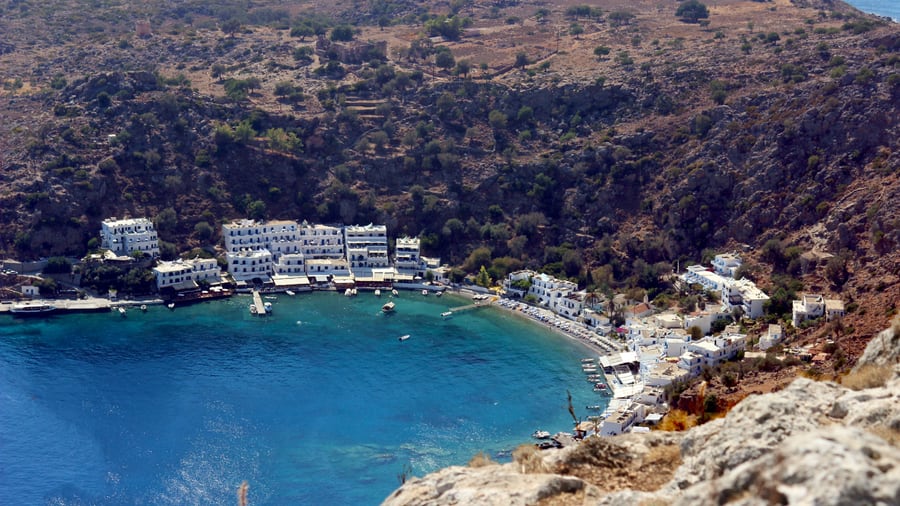
Loutro lies between Chora Sfakion and Agia Roumeli and is reachable only on foot or by sea. Cars stay in Chora Sfakion or Paleochora. The village stands on the site of ancient Phoenix, the port of ancient Anopolis, and keeps the ruins of a Venetian fortress beside a better-preserved Turkish one. Ferries run daily between Loutro and the nearby towns.
- Loutro: A village with no cars, reachable only on foot or by sea.
- Chora Sfakion: The capital of Sfakia, with two small harbours.
- Agia Roumeli: The village at the exit of the Samaria Gorge.
- Coastal boats: ferry boats link the villages.
Agia Roumeli was originally the ancient city-state of Tarra. In 1867 Turkish soldiers burned the town after failing to move up the gorge. An old fortress sits on a hill to the west. In summer, ferry boats carry hikers from here to Chora Sfakion, so a Chania boat trip on this coast ends where the gorge path begins.
Which boats run a Chania boat trip?
A Chania boat trip can use glass-bottom boats, traditional wooden boats, sailing boats, catamarans or private speedboats. Each type differs in hull, power and view, and all work on the Sea of Crete, the southern part of the Aegean.
A glass-bottom boat has sections of glass below the waterline, so passengers watch the underwater environment while staying dry. The view is better than looking into the water from above, because the glass removes surface disturbance. Tours on these boats include views of underwater flora and fauna, reefs and shipwrecks. On a Chania boat trip, this type shows the sea floor.
The caique is a traditional wooden boat of the Aegean. Its hull is built of pine wood and painted white to counter the powerful sun. It was used for fishing and trawling, and former fishermen now run it as an excursion vessel in the summer tourist trade on busy islands. A Chania boat trip on a caique rides a hull built for fishing.
A sailing boat is propelled partly or entirely by sails and is smaller than a sailing ship. A catamaran has two parallel hulls of equal size, and the wide distance between them adds stability. A motorboat that cruises at much higher speed is a speedboat. Snorkelling means swimming face-down with a mask and a breathing tube, which lets swimmers watch underwater life.
- Glass-bottom boats: Glass panels below the waterline show the sea floor.
- Wooden boats: Caiques are traditional pine boats of the Aegean.
- Sailing boats and catamarans: Sails or two hulls drive them.
- Speedboats and snorkelling: Fast motorboats and mask stops.
The Sea of Crete is the southern part of the Aegean, with a total surface area of 45,000 km2. Chania and Souda are two of its port towns, and Souda Bay is one of its bays. Every boat type above works on this water, so a Chania boat trip starts from a port town on the Sea of Crete.
What does a Chania boat trip see on the far west coast?
A Chania boat trip on the far west coast sees Falasarna, with its ancient closed harbour, then follows the south-west shore to Paleochora. Elafonisi is an island near the south-west tip of Crete. Paleochora and Elafonisi sit within the Chania regional unit.
Falasarna is a harbour town at the west end of Crete that flourished in the Hellenistic period. Its closed harbour is protected on all sides by city walls, with stone quays, mooring stones and two artificial channels to the sea. In 69 to 67 BC the Romans blocked the harbour with masonry. A Chania boat trip along this coast passes the shoreline where those channels once met open water.
Paleochora sits on the south-west coast of Crete, 70 km south of Chania, on a small peninsula 400 m wide and 700 m long. Its coastline runs for 11 km along the Libyan Sea. The Venetian general Marino Gradenigo built a fort there in 1278. Beyond the western corner of the island, the same boat route turns toward this southern shore.
Elafonisi belongs to the municipality of Kissamos. In fine weather, walkers can cross to the island on foot through the shallow water. The island is a protected nature reserve. The Elafonisi day trip post covers the island in full, while the sea route treats it as one stop on the coast.
- Acropolis: The acropolis rises on a cape 90 metres above the harbour and holds a temple of the goddess Dictynna.
- Boats: Ferry boats connect Paleochora with Sougia, Agia Roumeli, Loutro, Chora Sfakion and Gavdos.
- Name: Elafonisi means Deer Island in Greek.
Along the far west coast, the route passes three different layers of history and landscape. Falasarna belongs to the Hellenistic period, Paleochora carries a Venetian fort in its past, and Elafonisi is a protected shore. Which of them a boat can reach on a given day depends on the wind, which the next section explains.
When is the best season for a Chania boat trip?
A Chania boat trip suits the months from April to October, when clear-sky weather is almost an everyday feature in Chania. The etesian winds blow between late spring and the middle of September, so April and the weeks after that fall outside the windy window.
The climate of Chania is hot-summer Mediterranean, with dry sunny summers and wet mild winters. Frost and snow seldom reach the shore. Temperatures above 38 °C are uncommon, since the prevailing etesian winds from the Aegean Sea keep the heat in check. In the warm months, boats on the north coast meet a steady sea wind rather than extreme heat.
Greek speakers call the etesian winds meltemia. These strong, dry north winds come in periodic spells during the warm half of the year. They are at their strongest in the afternoon, and sometimes they continue for days at a stretch. Around Crete they blow as northwesterlies, so the open sea off the north coast lies in their path.
Wind direction depends on local topography, anywhere between north-east and north-west. In Chania the Lefka Ori mountain range stands to the south, and the winds of the west, south and north sides of Crete interact to form the local climate. The climate can vary by region and elevation, so the north coast and the Libyan Sea coast do not always match.
- April: This month falls before the etesian winds begin in late spring.
- Late spring to the middle of September: The etesian winds are active in this window, and gusts can reach Beaufort force 7 to 8.
- After mid-September: The windy window has closed, and clear-sky weather continues until October.
The etesian calendar sets the rhythm of a Chania boat trip. Clear skies run from April to October, and the strong north winds fill the middle of that stretch. The shoulder months on each side keep the sunny weather without the strongest wind, although the sea on the day still decides the route.
What do travelers ask about a Chania boat trip?
A Chania boat trip prompts five common questions: where the boat leaves from, where swimming is possible, how wind changes the sea, whether protected areas apply, and how the Samaria Gorge fits. The answers below rest on published facts.
Does a Chania boat trip leave from the old harbour or from Kissamos?
A Chania boat trip from the old harbour starts beside the old town, where the old Venetian harbour holds the Chania Lighthouse, dated 1864. From Chania, the port of Kissamos is 41 km to the west, at the far end of the regional unit.
Where can a Chania boat trip stop for a swim?
A Chania boat trip on the west and south-west coasts passes Falasarna, which has long sandy beaches and crystal-clear waters, and Paleochora, which has well organised beaches and isolated small anchorages. A CNN poll ranked Falasarna beach among the best 100 of the world.
How does wind affect a Chania boat trip?
A Chania boat trip meets etesian winds that arrive under clear skies with no warning, and gusts can reach Beaufort force 7 to 8. Winds at that strength stop certain yachts and inter-island ferries from sailing, so strong wind can cancel sailings.
Can a Chania boat trip be combined with the Samaria Gorge?
A Chania boat trip and the Samaria Gorge share the Libyan Sea coast. Walkers finish the gorge at Agia Roumeli, and from that village boats head east to Chora Sfakion and west to Sougia and Paleochora. The national park closes to visitors after October 31.
Does a Chania boat trip enter a protected area?
A Chania boat trip to Elafonisi reaches a protected nature reserve in the municipality of Kissamos. The Samaria Gorge is a national park where camping, overnight stays, fires and stream swimming are banned, so swim stops belong on the coast.
Featured photo: Geotiger18, CC BY-SA 4.0, via Wikimedia Commons.