An Aegina boat trip sails around the island of Aegina and its islets in the Saronic Gulf, close to Athens. It is one of the island cruises in Greece on Greece VIP.
This post covers what an Aegina boat trip includes, its harbours and Moni islet. It also covers the islets near Angistri, the north and west coast and the sea life. The Saronic Gulf, the best season and common questions come last.
Each section ends with an Aegina boat trip or a nearby cruise that can be booked online.
What does an Aegina boat trip include?
An Aegina boat trip uses a day-cruise ship, a ferry or a small tourist day boat. Ferries depart Piraeus, while Saronic Gulf day cruises leave from Flisvos Marina. Greek Law 4256/2014 sorts tourist boats by length and passenger capacity.
Ferries for day trips to Aegina leave from Gate E8, the Saronic islands gate of Piraeus. The port has 12 numbered gates. Gate assignments can change with traffic.
A car park with 700 spaces sits near Gates E7 and E8. The metro station lies in front of Gate E5, where a port shuttle bus starts.
Day cruises reach Hydra first, then Poros. On this Aegina boat trip, Aegina is the last island before Flisvos Marina. A buffet lunch is served on board.
Under Greek Law 4256/2014, small craft measure up to 7 metres. Pleasure vessels measure more than 7 metres overall. Both classes include sail and motor boats.
Under the same law, a professional pleasure vessel carries up to 49 passengers. Its safety certificate fixes the exact number, and any extra passengers are banned.
Each day-boat Aegina boat trip follows an announced route and returns to its start. Tickets carry a named passenger list. Boats need port authority approval to approach bathing facilities.
- Register: Day boats need a tax certificate and a register entry.
- Stops: Passengers cannot board or leave for good midway.
- Repairs: A damaged day boat sails for repairs only with port permission.
These rules cover each day-boat Aegina boat trip, from small craft to passenger tourist ships.


Which harbours does an Aegina boat trip use?
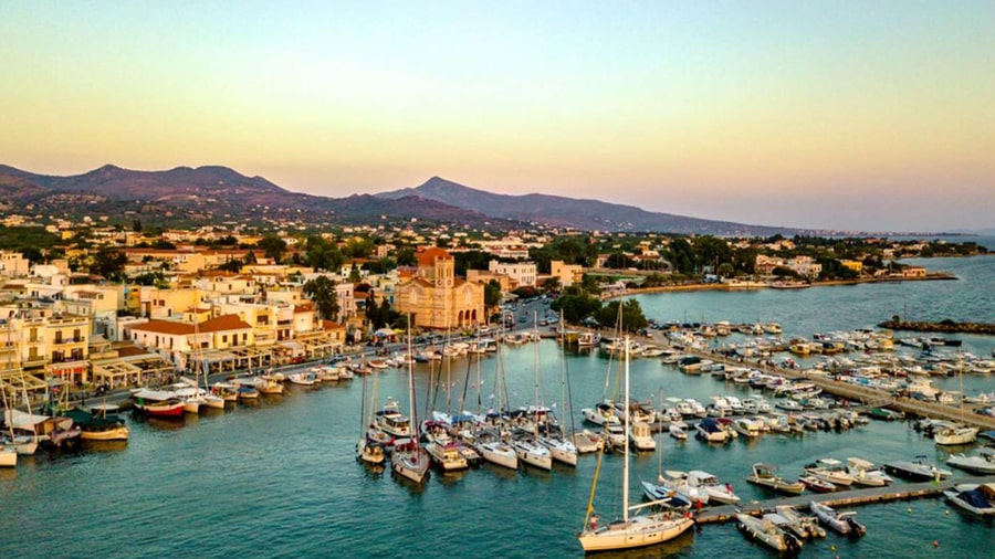
An Aegina boat trip uses Aegina town harbour, Souvala on the north coast, Agia Marina or Perdika. Ferries from Piraeus serve the first three ports. Perdika harbour runs a marina for boats. One Perdika beach sits at the harbour entrance.
An Aegina boat trip enters the town harbour past the chapel of Agios Nikolaos Thalassinos. Tradition says Parian builders raised it in the 17th century on ancient tower foundations.
After a boat collision, settlers from Psara placed a lantern on the chapel dome. Ioannis Kapodistrias later installed the free Greek state’s first harbour light at this port.
New harbour works buried the chapel in cement and cut its height by nearly a third. Aegina town spreads around this harbour, which handles heavy passenger and commercial traffic.
An Aegina boat trip to Souvala lands on the north coast. Its crescent-shaped harbour shelters fishing boats. Souvala stayed a small fishing village until fairly recently.
Locals link the name Souvala to stone cisterns, called souvales, dug 5 to 6 metres deep. Warm springs at 25.4 °C once existed on Souvala beach.
An Aegina boat trip to Agia Marina docks on the waterfront of a small northeast coast resort. Its Piraeus ferries take foot passengers only, not cars.
- Souvala rank: Souvala is the second-largest port on Aegina.
- Kapodistrias bust: A Kapodistrias bust stands at the harbour’s southwest end.
- Chapel repairs: The chapel was repaired in 1829 and 1845.
In summer, an Aegina boat trip to Moni leaves daily from Aegina town or Perdika.
What does an Aegina boat trip see at Moni islet?
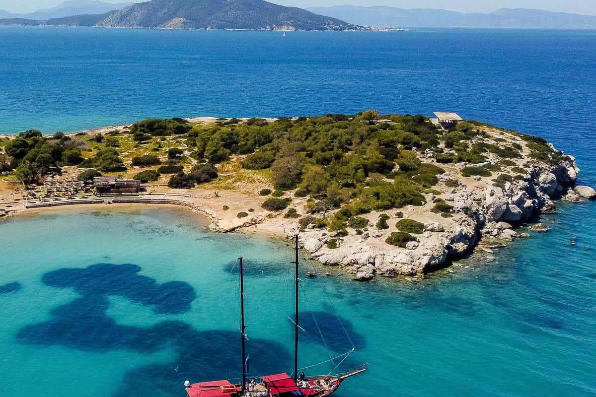
An Aegina boat trip to Moni reaches a pine-covered, uninhabited islet off Perdika. Deer, peacocks, kri-kri goats and squirrels live on it. The islet’s highest point rises to 179 metres. Overnight stays, even on private boats, are strictly banned.
An Aegina boat trip from Perdika harbour crosses 1,800 metres to Moni. It lies under 500 metres off the Perdika cape. It is about 1 nautical mile long.
The Holy Monastery of Chrysoleontissa on Aegina owns the islet. The name Moni, meaning monastery, comes from this owner. The islet serves as a refuge for wild animals.
From 1960 to 1990, a Greek touring club held the islet. Its members brought in the wild animals. In 1962 the islet became a nature park for game breeding.
Wild goats and pheasants live there too. Hares and ponies were brought in but did not survive. On an Aegina boat trip, tame animals walk up to visitors for food.
Pine forest covers the western side of the islet. A central hill carries wild olive, cedar and mastic shrubs. A German occupation lookout post stands on top.
Ruins of old camping facilities still stand on Moni. The rocky eastern side draws hikers and climbers. Its summits give wide views over Aegina and Perdika.
- West beach: Sand, sunbeds and a canteen line the western beach.
- East shore: The rocky side facing Aegina has deep water for spearfishing.
- Saronic group: Moni counts among the minor Saronic islands.
An Aegina boat trip from Perdika lands at Moni’s sandy western beach.
Which islets does an Aegina boat trip pass near Angistri?
An Aegina boat trip around Angistri passes Metopi, Doroussa, Kyra, Spalathronisi and Aponisos. All five count as islets or rocky islets near Angistri. Metopi sits in the channel between the two islands. Aponisos lies right beside Angistri, facing Aegina.
Metopi is a low islet about one nautical mile long. It lies between Aegina port and Cape Agios Georgios on Angistri, running west-southwest to east-northeast.
On an Aegina boat trip, the deeper and safer channel runs between Aegina and Metopi. The Angistri side is shallow, with dangerous shoals around the islet.
Metopi is the top of an old isthmus that joined Aegina and Angistri before sinking. Dense plants and vineyards cover it. A monastery on Aegina owns it.
Doroussa lies southwest of Angistri and had no residents in the 2001 census. A rubble wall from early Byzantine times still survives on its western side.
An Aegina boat trip passes Cretaceous limestone on Metopi and Angistri. Old quarry traces mark the beach between Megalochori and Dragonera. Builders used the stone at Epidaurus.
A small fenced bridge links Aponisos to Angistri. A shallow beach lies between the two islands. Its flat rock shore runs no longer than 150 metres.
- Kyra: Its other names are Pityonisos and Naias.
- Dragonera: This pebbly, unspoiled beach lies on Angistri’s west side.
- Skliri: A narrow path from Skala port reaches this beach.
An Aegina boat trip reaching Aponisos is close to Lekani, a salt lake with a sea canal. Nearby stands Agios Nikolaos, the first church on Angistri.
What does an Aegina boat trip see along the north and west coast?
An Aegina boat trip along the north and west coast passes Vagia, Souvala, Marathonas and Aiginitissa. The island’s north is mainly sedimentary rock. Marathonas is the large bay that dominates the west side. The whole island has 57 km of coastline.
An Aegina boat trip rounds Cape Plakakia, or Agion Apostolon, the island’s northwest tip. Further east lies Livadia bay, where traces of an ancient pier survive.
Souvala belongs to the Vathy community, which counted 1,449 residents in 2021. Vathy village sits 80 metres above the sea, about 10 km from Aegina town.
An Aegina boat trip passes the small Therma peninsula at Souvala, with its spa springs. Warm springs at Souvala beach once ran at 25.4 degrees Celsius.
Vagia sits on a small gulf about 14 km from Aegina town. The village had 236 permanent residents in 2021. It also has a fishing shelter.
East of Vagia, an Aegina boat trip passes a sandy beach. Opposite it lies a small islet with a chapel dedicated to the Life-Giving Spring.
Cape Tourlos marks the northeast tip of Aegina, near Vagia. A naval base built there in the 1930s has held a navy signal unit since 1994.
- Vagia wetland: The Grammatikos stream forms it where it meets the sea.
- Marathonas: This large west coast bay holds two sandy beaches.
- Aiginitissa: Eucalyptus trees line this sandy cove south of Marathonas.
Between Marathonas and the town, an Aegina boat trip passes the small cape of Palaiopyrgos, also called Aoni.
What sea life does an Aegina boat trip meet?
An Aegina boat trip crosses the Saronic Gulf, a nursery ground for hake. Loggerhead turtles feed or winter in the gulf. Twenty shark species have been recorded there. Six of them rank as endangered or critically endangered on the IUCN list.
Both an Aegina boat trip and the cruises to Hydra, Poros and Aegina cross the Saronic Gulf. The gulf has a mean depth of about 100 metres.
Dolphin species near an Aegina boat trip carry threat ratings. The striped dolphin counts as vulnerable in the Mediterranean, the short-beaked common dolphin as endangered.
In 2012, a young fin whale about 14 metres long appeared off northwest Aegina. It then stayed in the Saronic Gulf for two days to feed.
The critically endangered Mediterranean monk seal has been reported in the Saronic Gulf. Greek marine scientists call the gulf a hotspot for invading foreign species.
The Athens sewage plant on Psyttaleia has treated waste since 1994. Diffusers release about 800,000 cubic metres of treated water a day, 63 metres down.
Oxygen near the seabed reaches its lowest 6 to 14 km southwest of the plant. The sewage plume follows the main currents before it breaks down.
- Elefsis Bay: Its water below 20 metres loses oxygen in summer.
- Fish farms: A Salamis plan lifts farm space from 18.6 to 463.2 hectares.
- Bird zone: Natura 2000 site GR3000020 protects the Saronic Gulf islets and sea.
An Aegina boat trip now crosses a gulf whose seabed health has improved. Secondary treatment at Psyttaleia began in late 2004.
What does an Aegina boat trip see across the Saronic Gulf?
An Aegina boat trip crosses the Saronic Gulf, about 2,866 km² of sea. Its coastline runs for about 270 km. The deepest point reaches 416 m. Salamis, Psyttaleia, Fleves, Patroklos and the Corinth Canal sit on this gulf.
Agios Georgios, at the gulf’s entrance, is the largest uninhabited Saronic island. Its 73 MW wind farm sends about 250 GWh a year to Athens.
The gulf’s mouth runs about 27 nautical miles from Cape Sounion to Cape Skyllaion. Sounion also belongs to the coast seen on cruises along the Athens Riviera.
The gulf around an Aegina boat trip has western and eastern basins. In the west, the Epidaurus basin passes 400 m; Megara reaches 250 m.
Salamis cuts off the shallow Elefsis bay, about 30 m deep, from the wider gulf. The island hosts Salamis Naval Base, headquarters of the Hellenic Navy.
Psyttaleia, an islet of 0.375 km², lies between Piraeus harbor and Salamis. About 400 Persian troops held it before the sea battle of 480 BC.
Revythousa, an islet of about 0.18 km², lies 900 m west of Salamis. It has held a liquefied natural gas terminal since 1999, with two storage tanks.
- Fleves: The islet became a naval fort in 1920.
- Patroklos: Its ancient name honors the Ptolemaic admiral Patroclus.
- Canal end: The gulf forms the eastern end of the Corinth Canal.
The coasts around an Aegina boat trip hold Greece’s main ports and shipyards.
When is the best season for an Aegina boat trip?
August and September give an Aegina boat trip the warmest sea. The Saronic water column then spans 13 to 28 °C. February and March hold only 12 to 15 °C. Late summer winds blow mainly from the north.
Researchers at the Hellenic Centre for Marine Research give these Saronic ranges for the full water column. Salinity stays at 38 to 39 practical salinity units.
The National Observatory of Athens supplies a weather station at the High School of Aegina. It stands 40 m above sea level, posting live readings.
The station’s latest yearly summary marks August as the windiest month, averaging 10.5 km/h from the north. January was calmest: 6.4 km/h from the southeast.
A National Observatory of Athens study found strong summer northwest winds in the western Saronic Gulf. These Isthmus gap winds disrupt sailing, sea sports and fishing.
In the same study, west-northwest winds lead strong-wind cases southeast of the Isthmus in winter and spring. Northwest winds take their place there in summer.
A late-summer field campaign in southern Athens recorded northerly flow more than half the time. Southerly sea-breeze flow blew about 25 percent of the time.
- November wind: The Aegina station recorded mainly south-southeast winds.
- Top gust: The station logged 69.2 km/h from the south-southeast.
- Campaign window: The Athens measurements ran 26 August to 18 September.
For an Aegina boat trip, late summer pairs the warmest water with northerly winds.
What do travelers ask about an Aegina boat trip?
Line fishers on an Aegina boat trip keep up to 5 kg of fish daily. Swimming is banned in all Attica ports. Ferry passengers carry 50 kg of hand luggage free. Agia Marina is Aegina’s only Blue Flag beach.
Can passengers swim in a harbor during an Aegina boat trip?
No. The Greek Ministry of Health bans swimming in all ports, permanent anchorages and shipyards of Attica, Aegina included. Swimming is also banned within 50 m of storm-drain outlets. Around sewage outfalls, the ban reaches 200 m on each side.
Can a teenager spearfish on an Aegina boat trip?
Only from age 16. Presidential Decree 373/1985 bans spearfishing for anyone younger. Spearfishers must stay 200 m from bathing spots, port works and anchored ships. Breathing gear is banned, even on their boat. Fish under 150 g cannot be speared.
How much fish can a visitor keep from an Aegina boat trip?
Presidential Decree 373/1985 lets each line fisher keep 5 kg of fish, octopus or squid per 24 hours. A single heavier fish is the only exception. Each fisher keeps only one grouper. Selling a recreational catch is banned in Greece.
Can a dog join an Aegina boat trip on a Saronic ferry?
Yes. A Merchant Marine Ministry circular requires one pet cage per 200 passengers on covered ships. It counts pets up to 5 kg as small. On tourist ships and high-speed craft, larger pets stay on open deck where possible, muzzled and leashed.
How much luggage can a passenger take on an Aegina boat trip?
Greek Law 4948/2022 lets each passenger carry 50 kg of hand luggage at no extra fare. Passengers with reduced mobility carry needed equipment free, whatever its weight. The carrier is liable for luggage handed over for safekeeping against a receipt.
Does the island at the end of an Aegina boat trip have a Blue Flag beach?
Yes. Agia Marina is the only Blue Flag beach in the Municipality of Aegina on the current list. Attica holds 17 awarded beaches in total. The Municipality of Saronikos holds four of them. The Agistri municipality has no awarded beach there.