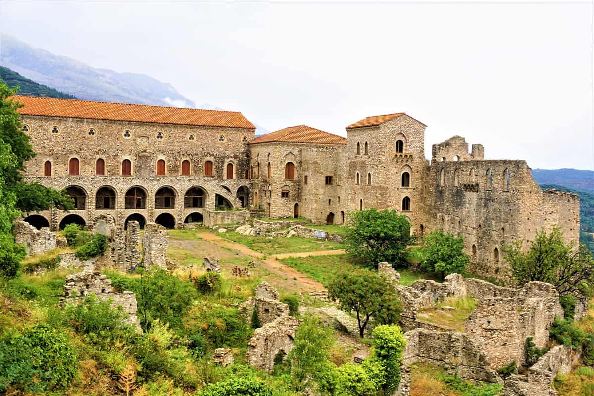
A Mystras tour climbs the hillside of the abandoned Byzantine city above the plain of Sparta in Laconia, from the Palace of the Despots and the castle on the summit to churches and monasteries painted with frescoes. This post covers what a Mystras tour includes, the history of the city and the Despotate of the Morea, the layout of the site, the palace, the castle, the Metropolis, the Pantanassa, the Peribleptos and the Brontochion, the frescoes, the scholars of Mystras, Sparta, Taygetus, getting there, Monemvasia and the best season. It is one of the historical tours in Greece on Greece VIP.
Each section ends with a Mystras tour or Peloponnese trip that can be booked online.
What does a Mystras tour include?
A Mystras tour covers the abandoned Byzantine city on a hill above the plain of Sparta in Laconia. The walk passes churches, monasteries, a palace and a castle, and it moves through streets that were laid out on a steep slope.
Mystras stands in Laconia, in the Peloponnese, on a hillside above ancient Sparta and below a Frankish castle. Pine and cypress trees grow around the ruins, and the walls of the empty town face the plain below. A Mystras tour shows a fortified town that grew under a fortress and later emptied, so its medieval plan survived and no modern building stands on the ruins.
The site keeps palaces, mansions and houses as well as churches and monasteries. Two private houses, built in the early fifteenth century, stand on vaulted substructures that held cisterns and stables, with a large room and a balcony above. A Mystras tour walks past these domestic remains, and the route shows how a late Byzantine town stored water and kept animals under the same roof.
Visitors who add a second day in the Peloponnese can pair the medieval town with older sites of the region. The Mycenae and Epidaurus day trip covers the citadel of Mycenae and the ancient theatre at Epidaurus, and it gives a longer stay in Laconia a second point of interest on the map. A Mystras tour also pairs well with that programme, because the two outings show different periods of Greek history.
- The town plan: lanes, squares and terraces of the late Byzantine settlement survive across the slope that a Mystras tour crosses.
- The palace: the residence of the rulers is the main secular complex that a Mystras tour reaches on the hill.
- The houses: mansions and smaller dwellings line the lanes of the lower quarter, with vaulted cellars beneath them.
- The museum: the Museum of Mystras displays objects that record the links between the town and western Europe.
Ruins cover a wide area, and the path from the entrance to the summit climbs without a break. Sturdy shoes help on the stone lanes. A Mystras tour gives a clear picture of a town that ended its life as a settlement and stayed whole as an archaeological site, with its houses, churches and squares laid out along a single slope.


How did Mystras begin on a Mystras tour?
A Mystras tour begins with a Frankish prince. William II of Villehardouin, ruler of the Principality of Achaea, raised a fortress above the plain, and the Byzantines took it from him in a peace deal. The town then grew below the walls.
In late 1248 William II of Villehardouin captured Monemvasia, the last Byzantine outpost in the peninsula, and completed the conquest that had begun in 1205 after the Fourth Crusade. He passed the winter of 1248 and 1249 in Laconia, choosing sites for new defences, and the castle on the hill was built in 1249. The prince then moved the seat of his government from Andravida to the new stronghold, and a Mystras tour starts from that decision.
Control changed hands after a battle. In September 1259 the prince was defeated and captured at the Battle of Pelagonia by the forces of the emperor of Nicaea, and he regained his freedom by swearing an oath of fealty and surrendering his strongholds in Laconia. The handover took place in 1262, and the castle became the seat of the Byzantine governor of the region, an officer called the kephale. The post changed hands every year at first, and only after 1308 did the governors serve for longer terms.
Warfare between Byzantines and Franks went on for decades. Byzantine attacks on the Frankish principality were beaten back at the battles of Prinitza and Makryplagi, and the raids pushed the people of the open country to seek safety. The inhabitants of Lacedaemon left their exposed town and settled under the fortress, and a new town grew along the slope. A Mystras tour follows that town from its first lane to the walls above, and the street plan still shows where the old roads ran.
- A poet prince: William II wrote verse, and his court kept a mint and a literary culture in its own form of French, a detail that a Mystras tour meets in the record of the principality.
- The broken oath: the prince renounced his promise soon after his release, so a Mystras tour follows a history of war as well as of building.
- The other forts: the prince also planned strongholds at Grand Magne and Leuktron before he chose the hill above the plain for the castle.
The town owed its start to a military decision rather than to trade or farmland, and the castle above it gave the settlement both protection and a reason to exist. A Mystras tour that opens with the founding story walks the same slope as the first settlers, from the lane at the foot of the hill to the wall of the stronghold.
What was the Despotate of the Morea on a Mystras tour?
A Mystras tour meets the Despotate of the Morea, the Byzantine province that governed the region from the hill town for the last century of the empire. Its despots belonged to the imperial family, and they held the province until the Ottoman army arrived.
The province took its final shape in 1349, when the emperor John VI Kantakouzenos reorganized the territory as an appanage for his son, the despot Manuel Kantakouzenos. Mystras became the residence of the ruler and kept that rank until the province fell. Manuel held peace with his Latin neighbours for the greater part of his reign, and an alliance with them contained Ottoman raids in the 1360s. A Mystras tour meets the court of a provincial capital in the buildings that the despots left behind.
After Manuel died in 1380 the rival Palaiologos family seized the region, and Theodore I Palaiologos became despot in 1383. He ruled until 1407, strengthened Byzantine authority and recognized the suzerainty of the Ottoman sultan. The despots who followed him were sons of the emperor Manuel II Palaiologos, and the family held the province for the rest of its life. The future emperor Constantine XI Palaiologos also ruled here as despot before he left the town for the throne of Byzantium.
The end came in 1460, when Sultan Mehmed II entered the region. The last despot, Demetrios Palaiologos, surrendered the town, and his brother Thomas fled. A Byzantine capital turned into an Ottoman provincial town, and the court that had drawn craftsmen, painters and scholars disappeared. The town that writers called the wonder of the Morea stayed inhabited through the Ottoman centuries, with a much smaller population, and a Mystras tour sees the change of scale in the empty lanes.
- The wider province: by 1430 the despotate covered the whole peninsula, and its rulers added Patras, so a Mystras tour covers the years when the province reached its greatest extent.
- The Hexamilion: in 1446 the sultan Murad II destroyed the wall at the Isthmus of Corinth and opened the road into the region.
- The last years: a revolt against the despots in 1453 and 1454 brought Ottoman troops into the province, and unpaid tribute drew the sultan back, as a Mystras tour records in the last years of the town.
Power moved between families and empires while the town on the hill stayed a seat of government. A Mystras tour reads that shift in the buildings of the site, from the residence of the ruler to the walls above, and the fall of the town from a capital to a ruin marks the end of Byzantine rule in the region.
How is the site laid out on a Mystras tour?
A Mystras tour follows a layout that UNESCO protects: the ruins were inscribed on the World Heritage List in 1989 under three cultural criteria. A citadel stands on the summit, walls run down the slope, and the town fills the space between the fortress and the plain.
UNESCO describes the property as a fortified city of the late Byzantine period with an elaborate plan that covers the whole slope. The ground falls steeply, so the town has an upper and a lower quarter, and the streets were laid out as footpaths, because wheeled traffic was useless on the slope. A Mystras tour climbs through both quarters on a single route.
The plan of the town records a main entrance at the foot of the hill, the Monemvasia Gate and the Nauplia Gate on the slopes, a Marmara entrance and an upper entrance to the highest part. Markets stood outside the walls, so the built area held public buildings and residences rather than shops. A Mystras tour passes each gateway in turn, from the lowest entrance to the last gate below the summit.
The architecture of the site mixes local and imperial models. Builders followed the Helladic school of Byzantine architecture as well as the architecture of Constantinople, and Romanesque and Gothic elements appear in the buildings, a result of the wide contacts of the fourteenth and fifteenth centuries. The mixed type of Mystras, a three-aisled basilica at ground level joined to a five-domed cross-in-square above, is the leading church plan on the hill, and a Mystras tour sees that design repeated across the town.
- The listed area: the World Heritage property takes in the upper town, the lower town and the castle on the summit.
- The precincts: the fortifications consist of the citadel on the hilltop and two fortified precincts at the lower level.
- Public works: water supply and drainage structures, workshops and trade quarters formed part of the fabric of the city that a Mystras tour crosses.
- Protection: the property is protected by Greek archaeological law and by ministerial decrees.
Walls, gates and stepped lanes organize the site, and the visitor who enters at the bottom climbs through the quarters in the order in which the town grew. The urban character of the ruins has come through the centuries without major human intervention. A Mystras tour covers the hill in one direction, and each level gives a different picture of a Byzantine city.
What does a Mystras tour see at the Palace of the Despots?
A Mystras tour reaches the Palace of the Despots, the residence of the Byzantine rulers of the hill town. The building occupies the main terrace of the slope and faces an open square, and its halls form the main group of secular buildings on the hill.
The palace took shape across the fourteenth and fifteenth centuries, and the last main building followed the form of the Tekfur Saray in Constantinople: three storeys, with a large audience hall on the top floor and apartments and storerooms below. The complex developed as independent, adjoining units, each added as the court needed space, so the wings of the building reflect the different reigns that shaped them. A Mystras tour sees the phases of that growth in the rooflines of the block.
The Palace of the Despots is the only Byzantine palace that still stands, and UNESCO counts the group among the rare survivals of imperial secular building. A Mystras tour enters the restored halls from the square on the terrace, where the ground opens wide before the slope falls away to the town below. The building gave the rulers of the region a residence fit for a court, beside the administration of the province.
- The Small Palace: a second residence stands apart on the hill and appears in the plan beside the main block.
- The restoration: the Committee for the Restoration of the Monuments of Mystras, supervised by the Ministry of Culture, is responsible for work on the monuments that a Mystras tour visits.
- The method: restorers follow research and scientific studies and use traditional techniques and materials.
The square in front of the palace once gathered the household of the ruler, and the halls above it served the court of the province. A Mystras tour that reaches this point has seen the town from the lane below to the hall above, and the building stands as the record of the government that worked there, with its rooms open to a Mystras tour today.
What does a Mystras tour see at the castle on the summit?
A Mystras tour finishes at the castle on the summit, the fortress that crowns the hill and closes the route. Its walls follow the rim of the rock, and from the top the view covers the whole valley of the Evrotas.
The hill under the fortress reaches 620 metres, and the fortifications close around the crest of the ridge. The plan of the site records an upper entrance to the citadel, so the last part of the climb passes through the line of the wall. From the top the ground falls away on every side, and the town lies below in terraces along the slope. A Mystras tour ends at this point because nothing stands above it.
The castle looks over the Evrotas valley, an 82 kilometre hollow between two mountain ranges that crosses Laconia and carries the main river of the region. The river flows north to south along the floor of the valley and empties into the Laconian Gulf. The valley is one of the largest in Greece, and the chief towns of Laconia stand on its floor, so a Mystras tour looks down on the farmland of the province.
The castle saw more fighting after the Byzantine period ended. The Venetians held the hill from 1687 to 1715. The Ottomans held it again until the Greek War of Independence, and a Mystras tour ends where the defences proved strongest.
- The farmland: citrus groves, olive groves and pasture cover the floor of the valley.
- The orange crop: the valley holds the largest orange production in the Peloponnese.
- The heat: the inland fields record the highest summer mean maximum temperatures in Greece.
The climb to the top passes the whole town before the castle appears, and the last stretch is the steepest. A Mystras tour that ends at the summit leaves the ruins below and the farmland beyond, and the walls above close the site in the same place where the settlement began. The summit is both the last stop of a Mystras tour and the oldest structure on the hill.
What does a Mystras tour see at the Metropolis?
A Mystras tour sees the Metropolis, the cathedral of Hagios Demetrios and the church of the bishopric that moved to the city. A three-aisled basilica rose on the spot after 1264, and a cross-in-square church was added above it in the first half of the 15th century.
The Metropolis stands near the main entrance of the site, at the head of the lower town, and it holds the rank of the mother church of the district. A narthex leads into the nave, and the two floors of the building mark the two great moments of its history. The church keeps its religious use from time to time, and a Mystras tour meets it as the first large monument after the gate.
Wall paintings in different styles cover the interior. Specialists date the oldest of them between about 1270 and the first quarter of the 14th century. The mixture shows how long the building stayed in use and how the hands of different painters met inside it. A Mystras tour sees religious scenes on the walls of the nave, and the eye can follow the change from the older work below to the painted dome above.
Mystras was the stage for the crowning of the last emperor of Byzantium, Constantine XI Palaiologos, in 1449. The ceremony gives the city a place in the story of the empire, and a Mystras tour links the event with the cathedral that stood at the centre of its public life. The museum of the site keeps sculpture and other finds from the city, and its displays show the links that Mystras had with Western Europe. The pieces come from the churches and the houses of the settlement.
- Bell tower: A bell tower stands above the western end of the church.
- Plan: The lower church is a basilica, and the upper church is a cross-in-square building.
- Dome: The dome was painted after the walls below it.
- Museum: Sculpture and finds from the city are kept on the site.
The Metropolis gives a Mystras tour the first clear picture of the city, a cathedral of the Byzantine provinces that served an imperial ceremony and kept a bishopric. A stop inside it sets the pattern for the churches that follow, where painting of the capital and painting of the provinces meet on the same walls, and where a Mystras tour can read the history of the town.
What does a Mystras tour see at the Pantanassa monastery?
A Mystras tour sees the Pantanassa, the monastery that John Frankopoulos, a chief minister of the Despotate of the Morea, founded and dedicated to the Virgin. Nuns live in the convent today, and they keep the church in use.
The Pantanassa belongs to the mixed architectural type that marks the churches of the city, where a basilica at ground level carries a domed church above. Byzantine forms meet Gothic elements in the design, and the monastery belongs to the last age of the despotate. A Mystras tour meets here the last of the great foundations on the hill, a house raised at the close of the Byzantine age.
The painted decoration belongs to the last years of Byzantine art. The work shows a mature style, with figures set in scenes that follow the rules of the period, and it is among the latest painted programmes that survive on the site. A Mystras tour sees the end of a tradition that had run for centuries, kept alive by a court that still paid for painters.
Monks left the house long ago, and a community of nuns occupies it now. These women are the only permanent residents of the archaeological site, and they keep the monastery open to visitors. Their presence gives the ruin a living side that the abandoned churches of the lower town no longer have. A Mystras tour sees a working convent, with a courtyard, a church in use and the small buildings of a community that still follows a rule of prayer and work.
- Date: The house was dedicated in September 1428.
- Porticoes: Exterior porticoes and a bell tower belong to the main church.
- Upper floor: The paintings of the upper church were made about 1430.
- Ground floor: Painters worked again in the lower church in the 18th century.
The Pantanassa closes the long series of churches at Mystras and keeps one of them alive. A Mystras tour ends the walk among painted walls here, with nuns at work in a monastery that has never lost its purpose, and with stone carving that shows how far Byzantine builders had travelled from the plain basilica of earlier centuries. A Mystras tour leaves the site here.
What does a Mystras tour see at the Peribleptos monastery?
A Mystras tour sees the Peribleptos, a monastery built into the side of a cliff with a cave that supports the structure. The first despot of the Byzantine province, Manuel Kantakouzenos, is credited with its foundation, and the main church carries a painted cycle made between 1348 and 1380.

The builders set the church against the rock and used the cave as part of the fabric, a solution that gives the building the look of a castle. The style spread to other churches and monasteries of the area, and the squared stones of the walls, with tiles set into them, became a mark of the local school. A Mystras tour sees a church that seems to grow out of the hillside, with the rock closing over it on one side.
The painted cycle is one of the rare late Byzantine cycles that survive, and it is important for the study of Byzantine art. The artists are not known, and space and movement in the scenes have a Western feel. The scenes flow from one wall into the next, and the Baptism of Christ is among the subjects that visitors pick out. A Mystras tour sees how the painters used the apse and the curves of the rock to set their figures in a continuous story.
The main church that a Mystras tour enters is a domed, two-column, cross-in-square building with chapels, and a tower beside it served as the refectory of the community. The monastery belongs to the group of houses on the hill that still stand, and its painted interior has been studied by scholars for a long time. A Mystras tour sees here how a small community arranged its church, its stores and its table, and how the monks fitted a full monastic life into a narrow shelf of rock.
- Rock: The cave behind the church forms part of the structure.
- Name: The house took the title of a famous monastery of the Byzantine capital.
- Cycle: The paintings run in a continuous sequence across the walls.
- Tower: A tower beside the church held the refectory of the monks.
The Peribleptos rewards a slow visit. The church hides in the rock, the paintings cover almost every surface, and the refectory tower stands as a reminder that a monastery was a working estate as well as a place of prayer. A Mystras tour that stops here sees the art of the late Byzantine world at close range.
What does a Mystras tour see at the Brontochion monastery?
A Mystras tour sees the Brontochion, a monastery of two churches: the Hodegetria, also called the Aphentiko, and the church of Saints Theodores. The abbot Pachomios rebuilt the Hodegetria as the main church around 1310, and the monastery later became a mosque under Ottoman rule.
The Hodegetria is the first example of the plan that scholars call the Mystras type. A three-aisled basilica fills the ground floor, a cross-in-square church rises above it, and a five-domed gallery is encircled by a portico that carries a belfry. Blind arches on the outside recall the architecture of the capital, and a Mystras tour sees a building that joins two traditions in one shell of stone.
The wall paintings of the Hodegetria were made between 1312 and 1322, and part of the work is connected with the art of the capital. A fresco of the Mother of God as the Life-containing Source fills the lunette above the royal door, and it is the image that greets visitors who enter the church. A Mystras tour sees in these walls the confidence of a monastery that served the ruling house, and the care that its patrons took over every surface of the interior.
The church of Saints Theodores is the older of the two that a Mystras tour visits. Monks named Daniel and Pachomios built it between 1290 and 1295, and its octagonal plan, with side chapels, follows a common Byzantine model. Paintings of the end of the 13th century cover the interior, and they belong to the first great campaign of decoration at the site. A Mystras tour sees the two churches as a pair, one from the years of the early despot and one from the years when the city was at its height.
- Title: The monastery carried the name of both of its churches.
- Marble: Marble panels cover the walls of the lower level.
- Burial: Theodore I Palaiologos, who died in 1407, lies in the church.
- Prayer: The Hodegetria keeps its religious use from time to time.
The Brontochion shows how a Byzantine monastery grew by adding one church to another. A Mystras tour sees the older building of Saints Theodores first, then the taller Hodegetria, where marble, painting and carved stone meet under a crown of domes that still stands above the ruins of the town.
Which Byzantine art does a Mystras tour show?
A Mystras tour shows the Palaiologan style, the last phase in the development of Byzantine art, which runs with the dynasty that ruled the empire from 1261 to 1453. The churches of the city carry painted cycles from that age.
Scholars describe a new style in the painting that a Mystras tour sees in these churches, marked by a multiplication of figures and scenes, by a fresh interest in perspective and by a return to models of an earlier age, such as illuminated manuscripts of the 10th century. A Mystras tour sees these habits in the crowded cycles of the churches, where a single wall carries a group of episodes from one story.
The figures of the period are slim and light. Bodies are drawn small in the head and wide in the frame, draperies hang in long folds, and the poses sway rather than stand. Buildings lean towards the centre of a scene to point the eye at the main event. A Mystras tour sees the rules of the style at work on every wall, from the small chapels to the great churches of the town.
The art of Mystras mattered far beyond the hill. Painting from the city shaped late and post-Byzantine work across the Peloponnese and in Crete, where the Cretan School carried the manner into later centuries. Private patrons began to appear in the pictures beside the saints, a change that gave the art of the period a new kind of witness. Innovation remained under the eye of the church, which kept watch over the images. A Mystras tour sees the art of the capital with Romanesque elements mixed into it.
- Landscape: The country behind the saints stays bare.
- Scenes: Narrative cycles replaced the single large portraits of saints.
- Signatures: Painters began to sign their work in this period.
- Reach: The manner shaped painting in the Greek lands long after the empire ended.
The painting of Mystras is the reason that the site holds a high place in the history of Byzantine art. A Mystras tour sees the last great age of that art in the place where it was made, on walls that have kept their colour and their stories through the centuries of ruin.
How did Mystras become a centre of learning on a Mystras tour?
A Mystras tour shows a city where the philosopher Georgios Gemistos Plethon taught, and his school turned Mystras into a centre of learning. Emperor Manuel II sent him to the city before 1410, and he spent the rest of his life there, teaching philosophy, astronomy, history and geography.
Plethon worked on different fronts in the city that a Mystras tour walks through. He compiled digests of classical writers, he was made chief magistrate by Theodore II, and the rulers of the province came to him for advice. A Mystras tour sees a place where the study of ancient texts was a public matter and where a scholar held office as well as taught. Learning of this kind had an audience far beyond the city, and pupils of the school later carried Greek letters to the West.
At the Council of Florence in 1438 and 1439 he set out the ideas of Plato for a Western audience, and the lectures he gave in Italy helped to open the Renaissance to Greek thought. The council met to discuss a union of the churches, and scholars who travelled with the emperor settled in Italy. Marsilio Ficino called him the second Plato, and Cosimo de’ Medici was moved by his teaching to found a Platonic Academy in Florence. A Mystras tour sees the city that sent this learning abroad.
The churches of Mystras were known for their libraries, and the writers of the city gave the place a name for learning that outlived its walls. Plethon died at Mistra in 1452. The name of the city travelled with his writings, which found readers abroad after his death, and a Mystras tour sees the town where a philosopher of the late Byzantine era spent his final years.
- Teacher: Plethon lectured on Plato and on Aristotle in the city.
- Students: His pupils included Bessarion and George Scholarius.
- Books: His book of laws was burned in 1460.
- Resting place: Followers of an Italian prince took his remains to Rimini.
The learning of Mystras is the part of the city that travelled furthest. A Mystras tour sees the ruins of the town where Plethon taught, and it follows a line of thought that reached the courts of Italy and the scholars who worked in them, long after the last despot had left the hill.
How does a Mystras tour connect with Sparta?
A Mystras tour starts about six kilometres north-west of Sparta, on the slopes above the Laconian plain, so the modern capital serves as the natural base, the meeting point and the last stop before the ruins that climb the hill.
Modern Sparta is the capital of the Laconia regional unit, and the modern streets cover the ground of the ancient city. King Otto decreed the expansion of the town in 1834, after the War of Independence, and the planned grid of wide, tree-lined streets replaced the older settlement that had lived among the remains of ancient Sparta. A Mystras tour fits easily into a stay in this provincial town, which keeps the administrative offices, the main square and the market of the region.
Ancient Sparta lies north of the modern centre, where the acropolis, the theatre and the sanctuary of Artemis Orthia remain visible. The limestone structure known as the Tomb of Leonidas belongs to the late fifth century BC and stands inside the planned town. The Archaeological Museum of Sparta, built from 1874, was the first Greek museum in a provincial city, and it holds finds from the excavations of the ancient site. The votive offerings from the sanctuary cover the ninth to the fourth centuries BC.
Below the ruins sits the modern village of Mystras, with the hamlet of New Mystras in the countryside nearby. Sparta also holds the Museum of the Olive and Greek Olive Oil at its south-western end, where the culture of the olive and the technology of olive production are presented. A Mystras tour that finishes in the town therefore ends with Byzantine stone and with the farming economy of the plain. The village sits below the ruins on the same slope.
- Population: The community of Mystras counted 724 residents in 2021, inside a municipal unit of 4,238.
- Elevation: The municipal unit of Mystras stands 310 metres above sea level.
- Area: The municipal unit covers 131.9 square kilometres of valley and lower slope.
- Administration: The 2011 local government reform placed the ruins inside the municipality of Sparta.
Sparta and the ruined town are joined by history as well as by tarmac. The medieval capital took the political weight of Laconia, then lost it to the new town on the plain, and the two names now appear on one signpost. A Mystras tour works best when it treats Sparta as the hinge: a place to sleep, to eat and to begin the climb.
What nature does a Mystras tour see on Taygetus?
A Mystras tour looks across the Evrotas Valley to the Taygetus range, the long mountain wall of the Peloponnese, and stands on the northern slopes of that massif, among pines and cypresses, above the olive groves, citrus groves and pasture of Laconia.
The mountain that frames a Mystras tour, Taygetus, runs about one hundred kilometres from the centre of the Peloponnese to Cape Matapan, and its highest summit, Profitis Ilias, reaches 2,405 metres. The slopes are forested mainly with Greek fir and black pine, although fires in 2005 and 2007 consumed much of the central western side, and about half of those woods remain. Creeks wash down from the massif on both sides, and the range dominates the skyline of Sparta and of Kalamata on the far side.
The valley that a Mystras tour overlooks stretches 82 kilometres between Taygetus and Parnon and measures 17 kilometres at its widest. Its floor is an agricultural region of citrus groves, olive groves and pasture land, and it carries the largest orange production in the Peloponnese. The river that gives the valley its name flows from north to south and empties into the Laconian Gulf, and a web of secondary roads crosses the plain between the two mountain walls.
Laconia covers 3,636 square kilometres and is bordered by Messenia to the west and Arcadia to the north, with the Myrtoan Sea on the eastern side. Parnon, the second range of the region, rises to 1,935 metres in the north-east. A Mystras tour that looks beyond the walls sees this double frame of mountains, the plain between them and the sea beyond the delta of the river. The final ten kilometres of the river cross rich alluvial soil at the head of the gulf.
- Summit: The highest point of Taygetus also carries the name Prophet Elias.
- Skoteini Plevra: The central part of the range is called the dark side, because its villages lose the morning and the evening sun.
- Cape Matapan: The massif reaches the sea at the southern end of the Peloponnese.
Nature and architecture share the same slope here. Pines and cypresses grow among the churches, the valley opens below the walls, and the peaks stay in view from the upper paths. A Mystras tour that looks outward sees the double mountain frame of Laconia, the water that feeds the groves and the light that falls across the plain.
How does a Mystras tour travel from Athens and Kalamata?
A Mystras tour from Athens joins the A8 motorway west of the capital and follows the A7 Moreas motorway south from Corinth, while a Mystras tour from Kalamata approaches over the Taygetus road that links that city with Sparta.
From Athens, the A8 motorway, known as Olympia Odos, runs west to Corinth, a city 78 kilometres from the capital and the main entry point to the Peloponnese. The Corinth Canal, completed in 1893, cuts the isthmus beside the city. Corinth also marks the northern end of the A7 Moreas motorway, which covers 147 kilometres to Kalamata; the stretch from Corinth to Tripoli accounts for 74 of them. The A71 branch, opened on 18 April 2016, runs 46 kilometres from Lefktro to Sparta.
From Kalamata, the EO82 national road links the coast with Sparta over 107 kilometres and passes Messini, Velika and the airport on the way. An older single carriageway, the EO7, connects Corinth with Kalamata over 195 kilometres, and the EO82 crosses the Taygetus range on its way east. A Mystras tour from the south therefore uses the motorway to Tripoli or the older road through the Messenian plain. The EO7 has been succeeded in importance by the A7 motorway.
Kalamata International Airport, coded KLX, lies between Kalamata and Messini on the EO82, west of the Pamisos plain, and its runway measures about 2.7 kilometres. The terminal road leads to the A7 motorway and to the EO7, and the same corridor serves the eastern side of the Peloponnese for a Nafplio day trip. Drivers who arrive at the airport reach Sparta on the national road, and the route ends below the walls of the site.
- A8 motorway: The Olympia Odos links Athens with Corinth and continues west to Patras.
- A7 motorway: The Moreas motorway runs 205 kilometres in total between Corinth and Kalamata.
- A71 branch: The Lefktro to Sparta section is a toll road.
- Kalamata airport: The airport receives flights mainly in the summer months.
The road network of the southern Peloponnese makes the site reachable from both sides. Motorway traffic from Athens passes Corinth, Tripoli and the plateau of Arcadia before the branch to Sparta, while traffic from Kalamata climbs from the Messenian plain. A Mystras tour therefore suits travellers who arrive through Athens or through Kalamata International Airport.
How does a Mystras tour compare with Monemvasia?
A Mystras tour covers a hill town that climbs a steep hillside, while Monemvasia keeps its houses on a rock beside the sea; both are Byzantine settlements of Laconia, and the two belong to one itinerary across the regional unit.
Monemvasia stands on a tied island off the eastern coast of the Peloponnese, in the Myrtoan Sea, joined to the mainland by a tombolo 400 metres long, and it forms the sea counterpart of a Mystras tour. An earthquake in 375 AD cut the rock away from the coast, and its plateau now rises about 100 metres above the water. The lower town is walled on three sides and entered through the west gate, where a road crosses the causeway. A small hamlet of about ten houses lies nearby.
The contrast that a Mystras tour draws is one of shape and of light. Mystras climbs a hillside and was inscribed by UNESCO in 1989 under cultural criteria two, three and four, as an exceptionally well-preserved late Byzantine city. Monemvasia keeps its houses inside a compact castle on the rock, with the church of Hagia Sophia on the plateau. One town looks down on a valley of olives and citrus; the other looks out on open water.
The two towns grew in the same Byzantine world, and each one defended a different kind of ground. Monemvasia was the last Byzantine outpost on the Morea when it was taken in 1248. A Mystras tour that adds the rock town gives two pictures of one era: a defended harbour and a defended mountain. The wider municipality of Monemvasia counts 21,816 residents, and the two lie in the same regional unit.
- Upper town: The plateau settlement was abandoned after the second Venetian occupation and is reached by a winding path from below.
- Fortress: The acropolis on the summit held four towers and dates from the sixth century.
- Streets: The lanes of the rock town suit pedestrians and donkeys.
- Roads: The EO86 national road covers 69.7 kilometres from Dafni, south of Sparta, to Monemvasia.
Choosing between the two is a question of taste rather than of quality. The hill town offers churches, frescoes and a long view over the plain; the rock town offers the sea, the walls and the causeway. A Mystras tour and a Monemvasia tour fit into one Laconia itinerary, with Sparta as the shared base.
When is the best season for a Mystras tour, and is it accessible?
A Mystras tour suits spring and autumn, when the Laconian plain is mild and the paths are dry; summer brings intense heat, and the site itself is a steep, stepped hillside where the lanes were built for walkers rather than for vehicles.
Sparta and the Evrotas Valley record the highest summer average maximum temperatures in Greece, under a Mediterranean climate with hot, dry summers. July and August highs reach about 36 °C, January highs about 14 °C, and the highest reading ever taken in the city was 45.7 °C, in August 2021. The wettest months fall in winter, while a Mystras tour in the dry season meets long spells without rain.
The interior of the valley sits about 30 kilometres from the sea and is cut off from cooling winds, which makes it hotter than the coast. Spring fills the citrus and olive groves below the ruins, and autumn follows the harvest of the region. Visitors arrive in the largest numbers in the warm months, when the archaeological site is at its busiest. A Mystras tour in spring or autumn therefore sees the plain at its best.
Access inside the walls follows the shape of the hill, and a Mystras tour moves between the upper and the lower zones on foot. Drinking water facilities stand near the central entrance of the site, where two ticket offices also serve arrivals. Water, sun protection and firm shoes keep the climb comfortable on a warm morning, and the slope rewards anyone who takes it slowly.
- Steps: The slope ruled out wheeled traffic, and the streets of the site work as footpaths.
- Shade: Pines and cypresses cover parts of the hillside and break the sun along the route.
- Heat: Sparta records five days each year with temperatures above 40 °C, which shapes the season of a Mystras tour.
Weather shapes the day on the hill more than anything else. Spring and autumn give mild air and dry stone, high summer brings intense heat, and the height above the valley floor adds a little relief. A Mystras tour arranged for the shoulder months, with water and firm shoes, keeps attention on the churches, the walls and the view.
What do travelers ask about a Mystras tour?
A Mystras tour raises the same questions in every group: whether children can manage the climb, how much walking the site demands, which entrance to use, and whether Sparta or Ancient Olympia can be added to the same journey.
Can children join a Mystras tour?
The World Heritage listing notes rising interest in the site from schools and university students, along with a programme of educational events, so family groups are a familiar sight. The Greek Ministry of Culture also publishes an online presentation of the Byzantine town written for young explorers, which prepares children for the churches, the walls and the climb.
How much walking does a Mystras tour involve?
The town runs down the hillside from a fortress built at the top of a hill 620 metres high. Movement follows the slope between two fortified precincts, so the effort is steady rather than flat, and the ground rises all the way.
Does a Mystras tour use the upper or the lower entrance?
The site records a main entrance, a separate upper entrance to the citadel, and a third gateway known as Marmara. The main gate leads up through the lower zone, and the upper gate serves the summit of the hill. A Mystras tour that begins below therefore passes the churches first and finishes at the top.
Can a Mystras tour be combined with Sparta?
Mystras and Sparta share one landscape and one road network, and the town supplies the museums and services that a visit needs. The wider municipality of Sparta counts 32,786 residents. The ruins sit close to the centre, so the two places are seen together, and a Mystras tour based in the town reaches the site without a long transfer.
Can a Mystras tour be combined with Ancient Olympia?
The two places belong to different parts of the Peloponnese: Olympia lies in the Elis regional unit, on ground about 60 metres above sea level, and it holds a World Heritage property listed by UNESCO. A Mystras tour and an Ancient Olympia tour can share one longer journey.
Featured photo: Joyofmuseums, CC BY-SA 4.0, via Wikimedia Commons.