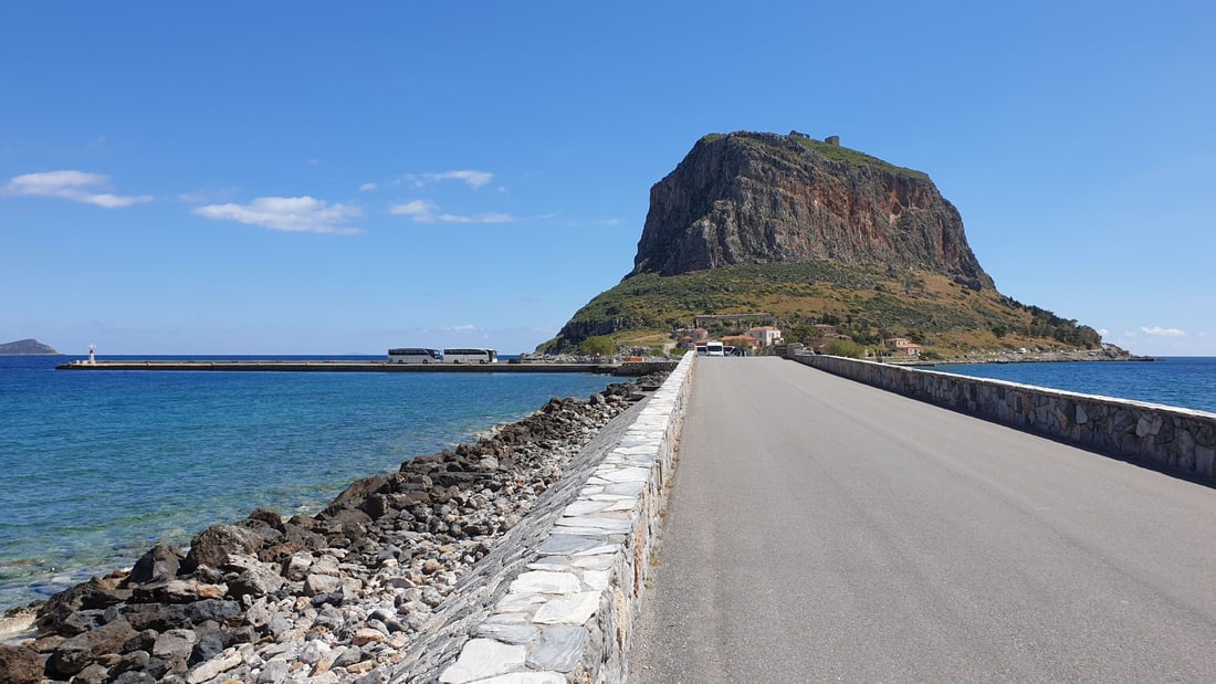
A Monemvasia tour crosses the causeway to the great rock off the coast of Laconia and enters the walled medieval town through its single gate, then climbs to the ruined upper town and the church of Agia Sofia on the edge of the cliff. This post covers what a Monemvasia tour includes, how the rock is reached, its history, the lower town, the upper town, the poet and the wine linked to its name, the sights nearby and the best season. It is one of the history tours in Greece on Greece VIP.
Each section ends with a Monemvasia tour that can be booked online.
What does a Monemvasia tour include?
A Monemvasia tour covers a medieval fortress town on a tied island off the east coast of Laconia. The route runs through the walled lower town and up to the abandoned upper town, while an escorted tour leader explains the churches, walls and gates.
Monemvasia is a tied island, which means that a sandy isthmus called a tombolo joins it to the mainland. The Myrtoan Sea surrounds the rest of the rock. The top of the island is a large plateau about 100 metres above sea level, up to 300 metres wide and 1 kilometre long. A Monemvasia tour starts below that plateau, in the lower town.
The lower town stands on the southern coast, under the southern wall of the upper town, and walls close it on the east, south and west. The upper town occupies the plateau and has had no residents since the second Venetian occupation. A Monemvasia tour climbs a winding cobbled path with two intermediate gates to reach it, and its acropolis was a rectangular fortress with four towers.
The Nafplio day trip covers a city on the shore of the Argolic Gulf, in the north-eastern Peloponnese, while a Monemvasia tour covers a tied island in the Myrtoan Sea. Nafplio was the first official capital of Greece, from 1827 to 1834. By 1537 Nafplio and Monemvasia were the two remaining Venetian possessions in the Peloponnese, and both went to the Ottomans through the treaty of 1540.
- Lower town: The sea wall has two corner towers, five further towers and a gate in its middle.
- Upper town: The wall called Goulas fortifies the north and south sides, and cliffs protect the rest.
- Churches: Hagia Sophia stands in the upper town, and Christos Elkomenos in the lower town.
Monemvasia is one of the oldest continually inhabited fortified towns in Europe. At one point it ranked among the foremost commercial centres of the Eastern Mediterranean, and its town walls and Byzantine churches remain. The town carries the nickname Gibraltar of the East. A Monemvasia tour joins the rock, the two towns and these remains in one route.


How does a Monemvasia tour reach the rock?
A Monemvasia tour reaches the rock over a causeway from the mainland, where the settlement of Gefyra stands opposite it. A road from the bridge over the causeway leads to the west gate, and entry to the walled lower town is through that gate.
A Monemvasia tour visits a rock that belongs to Laconia, a historical and administrative region on the south-eastern part of the Peloponnese peninsula. Laconia has been a regional unit with Sparta as its capital since 2011. Messenia borders it on the west and Arcadia on the north, and the Myrtoan Sea lies to the east. The Taygetus range reaches 2,407 metres in the west and the Parnon range 1,961 metres in the north-east.
The sandy tombolo between the rock and the mainland measures 400 metres in length. In 1890 a small part of it was cut to create an artificial bridge for ships and boats. In 1971 a bridge on the western side linked Monemvasia with the rest of the country through the EO86 road. A Monemvasia tour now crosses to the rock by that bridge.
Gefyra is the mainland settlement opposite Monemvasia, and the Greek word gefyra means bridge. Residents of the rock moved to Gefyra or emigrated to Athens. In the 1951 census, 261 of the community’s 522 residents lived in Gefyra, 178 in the old town and 83 in Agia Kyriaki. Gefyra then grew strongly, and the 2011 census counted 1,299 inhabitants there. A Monemvasia tour crosses from this mainland side.
- Reform: The 2011 administrative reform merged Asopos, Molaoi, Monemvasia, Voies and Zarakas into one municipality.
- Seat: The municipality of Monemvasia has its seat in Molaoi, not on the rock.
- Area: The municipality covers 949.3 square kilometres.
The upper town once had two entrances. The Ottomans sealed the one on the north side during their first rule, and the Venetians named the wall that closed it Mura Rossa, the Red Wall, and placed cannons in it. Today a fortified gate is the only way into the upper town, so a Monemvasia tour reaches the plateau by that single route.
What history does a Monemvasia tour tell?
A Monemvasia tour tells the history of a town founded in the sixth century by settlers from Sparta, which became a Byzantine trading port, passed between Venice and the Ottomans, shrank to 32 old-town residents in 1971 and revived as a tourist destination.
Monemvasia was founded in the sixth century when the people of ancient Sparta relocated. The Chronicle of Monemvasia ties the move to a Slav raid of 587 and 588. Archaeology points earlier, since the first level of the Christ Elkomenos basilica dates from the reign of Justinian. The name joins the Greek words moni, meaning single, and emvasis, meaning approach, so a Monemvasia tour enters a town named for its one entrance.
From the 7th century Monemvasia grew into a commercial and cultural centre on the sea route to Sicily. Roger II of Sicily failed to take the city in 1147. William of Villehardouin captured it in 1225 after a three-year siege, and Michael VIII Palaiologos recovered it in 1262. The land that William surrendered became the nucleus of the Despotate of the Morea, and a Monemvasia tour places the golden age before 1460.
Demetrios Palaiologos surrendered Monemvasia to Mehmed II in 1460, and on 12 September 1460 the inhabitants offered the city to Pope Pius II. By the end of 1463 it had fully fallen to the Venetians. Suleiman I took Monemvasia and Nafplio in 1540, and the inhabitants took refuge, mainly in Corfu and Crete. Girolamo Corner entered the town for Venice on 12 August 1690, and the Ottomans retook it on 7 September 1715.
- 1821: The Greeks took the fortress on 23 July after a four-month siege.
- 1971: Only 32 residents lived in the old town, and electricity arrived the next year.
- 1970s: Visitors bought houses from the people of Monemvasia and restored them.
Restoration turned the medieval buildings into a tourist destination, and the restored buildings now include hotels. A celebration of independence takes place in the main port on 23 July, where speeches recount the story of Tzannetakis Grigorakis and his men in Greek and English. A Monemvasia tour closes its history with the town that this revival brought back.
What does a Monemvasia tour show in the lower town?
A Monemvasia tour shows the lower town on the southern coast of the peninsula: its walls, the main street, the central square, the church of Christos Elkomenos, Panagia Myrtidiotissa and the old mosque, which now holds the archaeological collection of Monemvasia.
The lower town lies under the southern wall of the upper town and is walled on three sides. A Monemvasia tour enters by the west gate, which a road links to the bridge over the causeway. The main street, called the Middle Street in the Byzantine period, runs past shops to Elkomenos square, where the metropolitan church, the former mosque and the episcopal palace stand.
The church of Christos Elkomenos is a three-aisled basilica with a dome. The first church dates to the 6th century AD, and sculptures above the door show a second phase in the 11th and 12th centuries. Panagia Myrtidiotissa stands north of it, built in the second Venetian period in a district where Cretans settled. A Monemvasia tour sees a one-room basilica with a round skylight.
The Ottomans erected a mosque south of the square in 1540. It served as a hospice under the second Venetian rule, became a mosque again in 1715, then a prison and later a cafe. Since 1999 the old mosque has held the archaeological collection that a Monemvasia tour visits. The vaulted ground-floor hall holds architectural sculptures, everyday ceramics, and a small number of coins, lamps and glass objects.
- Episcopal palace: A Venetian lion relief survives above the entrance of the old bishop’s residence.
- Streets: Lanes are narrow cobblestones, sometimes roofed by vaulted passages called dromi.
- Squares: Megali and Mikri Tapia squares were added in the 19th century.
Smaller churches fill the lanes around the square. Panagia Chrysafitissa stands near the sea wall and was built by the Ottomans with Islamic influences. Agios Nikolaos carries an inscription naming Andrea Licinio as builder in 1703. Agios Antonios keeps worn frescoes from the late 13th or 14th century. A Monemvasia tour passes these churches.
What does a Monemvasia tour show in the upper town?
A Monemvasia tour shows the upper town on the plateau above the lower town: the winding path up the cliff, the fortified gate, the ruins of the acropolis, houses and cisterns, and the church of Agia Sofia near the edge of the cliff.
A winding cobbled path rises from the lower town to the fortified gate of the upper town, past two intermediate gates. A road with parapets, battlements and lookouts circles the cliff. The plateau lies about 100 m above sea level, up to 300 m wide and 1 km long. A Monemvasia tour climbs to a town with no residents today, abandoned after the second Venetian occupation.
The acropolis stood at the highest point of the rock as a rectangular fortress with a tower at each corner and a gate in the eastern wall. Its walls were mudstone with a fortified mortar. The Venetians replaced the south-western tower with a rectangular powder magazine. A building near the centre had a cistern. A Monemvasia tour sees these ruins on the summit.
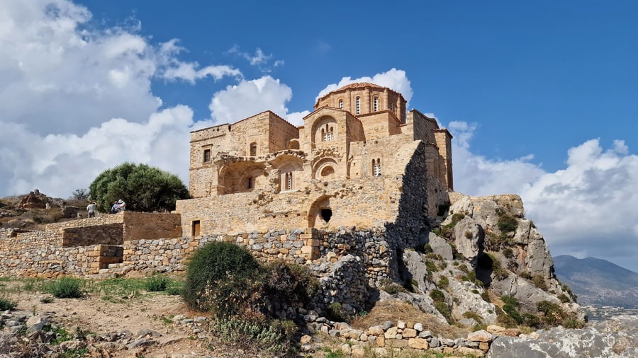
On a Monemvasia tour, Agia Sofia (Hagia Sophia) stands near the edge of the cliff. The church dates to about 1150 and was first dedicated to Panagia Hodegetria. The main room measures 14 by 14 metres, and the dome, 7 metres across, has 16 windows. Frescoes survive from the 12th century, including two archangels in the narthex and Christ as the Ancient of Days in the sanctuary.
- Cisterns: Three large public reservoirs stand in the western part of the upper town.
- Fountain: An Ottoman fountain with four sides and a dome stands near them.
- Bathhouse: A ruined 17th-century bathhouse near Agia Sofia keeps its small dome.
The church changed use with each ruler. It was the Fethiye Mosque from 1540 to 1690, and under the second Venetian rule it served a monastery of Madonna del Carmine. After a second period as a mosque from 1715 to 1821, the minaret was demolished and the church returned to Christian worship. A Monemvasia tour reads this record in the walls.
Which local stories does a Monemvasia tour tell?
A Monemvasia tour tells two local stories: the poet Yannis Ritsos, who was born in Monemvasia in 1909, and Malvasia, or Malmsey, the wine whose name comes from the Italian form of the town’s name and spread through Venetian trade.
Yannis Ritsos was born in 1909 into a well-to-do landowning family in Monemvasia. His mother and eldest brother died of tuberculosis, his father struggled with mental illness, and the family was ruined economically. Ritsos spent the years from 1927 to 1931 in a sanatorium for tuberculosis. He joined the Communist Party of Greece in 1934. A Monemvasia tour counts him among the notable people of the town.
A Monemvasia tour tells how a photograph of a dead protester at a tobacco workers’ demonstration in Thessaloniki in 1936 inspired his poem Epitaphios. The Metaxas dictatorship came to power that August, and the poem was burned publicly at the foot of the Acropolis. In the 1950s Mikis Theodorakis set it to music, and it became an anthem of the Greek left.
Monemvasia traded wine so widely, especially under Venetian administration, that its name became familiar across Europe through the wine called Malvasia, which English calls Malmsey. Malvasia is the Italian form of the town’s name. The wine was not grown locally. It came from the Peloponnese and from Cyclades islands, especially Tinos. A Monemvasia tour explains this trade at the port that served it.
Ampelographers believe the Malvasia grape family originated in Crete. Malmsey was one of three major wines exported from Greece in medieval times. English tradition links it to the death of George Plantagenet, Duke of Clarence, in 1478, when rumour held that he drowned in a butt of malmsey. Malmsey now names almost exclusively a sweet Madeira wine made from the Malvasia grape.
- Recognition: Louis Aragon called Ritsos the greatest poet of the age.
- Exile: In 1967 the Papadopoulos dictatorship sent Ritsos to a prison camp on Gyaros, later to Samos and Lemnos.
- Wine shops: Merchant wine-shops in Venice were known as malvasie.
A Greek grape variety named Monemvasia now grows primarily in the Cyclades. It was long thought to be the ancestor of the western European Malvasia varieties, but DNA analysis does not suggest a close relationship. Ritsos was on the Nobel Prize shortlist in 1973. A Monemvasia tour closes these stories at the town that gave the wine its name.
What can a Monemvasia tour add nearby?
A Monemvasia tour can add Mystras, the Byzantine fortified town above ancient Sparta that UNESCO inscribed in 1989, and Elafonisos, a small island off Cape Malea with light-coloured sandy beaches. Both places belong to Laconia, the same regional unit as Monemvasia.
Mystras rises on a slope of the Taygetos mountains, above the modern village of Mystras and the city of Sparta. William II of Villehardouin built the fortress after he completed his conquest of Laconia, and the Byzantines took it over in 1262. The same handover included Monemvasia, so a Monemvasia tour that adds Mystras follows one chapter of Laconian history across two sites.
From 1349, Mystras was the residence of a despot who ruled the Byzantine Morea. The philosopher Gemistos Plethon lived there until his death in 1452. Constantine XI Palaiologos, the last Byzantine emperor, served as despot of Mystras before he took the throne. Frescoes still decorate the Hagia Sophia church on the site, and the Palace of the Despots is the only Byzantine palace that survives today.
Elafonisos lies between the Peloponnese and Kythira and covers 19 square kilometres. It is the largest inhabited island of the Peloponnese archipelago and the only one that forms a separate municipality. Sarakiniko, Fragos (Simos) and Panagias Nissia are among the best-known beaches. The community also includes 3 square kilometres of mainland, which consist mainly of Punta Beach. Laconia has five municipalities, and Elafonisos and Monemvasia are two of them, so a Monemvasia tour that adds the island crosses a municipal boundary.
- Setting: Mystras has distinct upper and lower city zones, shaped by the steep slope.
- Churches: St. Demetrios, Hagia Sophia, St. George and the Monastery of Peribleptos still stand.
- Pavlopetri: A sunken city from the early 3rd millennium BC lies just off the coast of Elafonisos.
Mystras changed hands again in 1460, when Demetrios Palaiologos surrendered the city to Sultan Mehmed II. The Venetians occupied it from 1687 to 1715, and the Ottomans held it otherwise until 1821. After the massacre of 1825, the town was rebuilt 9 km away under the name Sparta in 1831. The only inhabitants today are a group of nuns at the Pantanassa Monastery, so a Monemvasia tour that visits Mystras enters an archaeological site.
When is the best season for a Monemvasia tour?
A Monemvasia tour meets a very hot-summer Mediterranean climate with mild winters, and spring and autumn sit between those two seasons. The Csa class of the Köppen system describes the climate of both Monemvasia and Sparta, the capital of Laconia.
The highest temperature on record at Monemvasia is 45.2 °C, logged on 26 June 2007. The lowest is 1.6 °C, logged on 17 February 2008. A World Meteorological Organization station of the National Observatory of Athens stands in mainland Greece, just off the tied island. The area lies in plant hardiness zone 11a, and no other part of mainland Greece belongs to that zone.
Summer produces the record readings that a Monemvasia tour meets. On 27 June 2007 the 24-hour minimum at Monemvasia was 35.9 °C, the highest minimum ever recorded in mainland Greece. Monemvasia records 133 tropical nights per year. Sparta posts the highest summer average maximum temperatures in Greece, with July and August highs around 36 °C. In July 2012, its average maximum reached 38.3 °C.
Winter stays mild, and Monemvasia has recorded no snow accumulation in the past 80 years. Sparta reaches January highs around 14 °C. Elafonisos shows the seasonal swing clearly: between 300 and 350 people live there in winter, while July and August bring over 3,000 visitors per day. A Monemvasia tour that adds the island in high summer meets that peak.
- Sparta record: The highest temperature recorded there is 45.7 °C, in August 2021.
- Hot days: Sparta records 5 days per year above 40.0 °C.
- Island traffic: July and August visitors bring 1,600 cars to Elafonisos.
On July 23, an independence day celebration takes place in the main port of Monemvasia. Speeches are made, and the story of Tzannetakis Grigorakis and his men is told in both Greek and English. A ship built every year is filled with pyrotechnics and set on fire. The fortress surrendered to the Greeks on the same date in 1821, after a four-month siege.
What do travelers ask about a Monemvasia tour?
A Monemvasia tour visits a fortified town founded in the sixth century on a tied island in the Myrtoan Sea, one of the oldest continually inhabited fortified towns in Europe, where the upper town stands empty and the lower town keeps narrow cobblestone streets.
Can cars enter the old town on a Monemvasia tour?
The streets of the old town are narrow and fit only for pedestrian and donkey traffic. A road links the bridge over the causeway to the west gate of the lower town, and the main street continues inside from that gate. In 1971, a bridge on the western side linked Monemvasia to the EO86 road.
How does a Monemvasia tour reach the upper town?
A Monemvasia tour climbs a winding cobblestone path from the lower town to the fortified gate of the upper town, passing two intermediate gates. The upper town stands on a plateau about 100 metres above sea level and 1 kilometre long. A road with parapets was built around the cliff to avoid the risk of falling.
Can a Monemvasia tour include a stay inside the walls?
A number of the restored medieval buildings are now hotels. From the 1970s, the people of Monemvasia sold their houses to visitors, who restored them. Only 32 residents lived in the old town in 1971, and the upper town is no longer inhabited.
Which mainland settlement faces the rock on a Monemvasia tour?
Gefyra lies on the mainland opposite Monemvasia and had 1,299 inhabitants in the 2011 census. In 1951, the community had 522 residents, with 261 in Gefyra, 178 in the old town and 83 in Agia Kyriaki. Gefyra grew strongly from the 1970s, as Monemvasia flourished again as a tourist destination.
Where is the lighthouse on a Monemvasia tour?
The lighthouse stands at the eastern end of the island. It was built in 1896 and began operation in 1897, with a focal height of 15 metres above sea level and a beam that reaches 11 nautical miles. A marble staircase leads to the lighthouse cage, and a small exhibition covers the Greek network of lighthouses.
Featured photo: Rc1959, CC BY-SA 4.0, via Wikimedia Commons.