
A Kefalonia boat tour follows the coast of Kefalonia, the largest of the Ionian Islands, past white cliffs and pebble bays, and can cross the strait to Ithaca. This post covers what a Kefalonia boat tour includes, the ports, Myrtos and the west coast, Ithaca, Melissani and the caves, the wildlife, the history and the best season. More Greece tours are listed on the Greece VIP homepage.
Each section ends with a Kefalonia boat tour that can be booked online.
What does a Kefalonia boat tour include?
A Kefalonia boat tour is a sea trip around the largest of the Ionian Islands. Routes follow the coast past bays, cliffs and villages, call at nearby islands such as Ithaca, or enter the Melissani cave near Sami by boat.
Kefalonia is the largest of the Ionian Islands and the sixth-largest island in Greece. It covers 773 square kilometres in the Ionian Sea, west of mainland Greece. The island has four main harbours: Argostoli in the west, Sami on the east coast, Fiskardo in the north and Poros in the south. A Kefalonia boat tour can therefore begin on any side of the island.
The Ionian Islands are a group of islands in the Ionian Sea, traditionally called the Heptanese. From north to south, the seven principal islands are Corfu, Paxos, Lefkada, Ithaca, Kefalonia, Zante and Kythira. Six of them lie off the west coast of Greece, while Kythira lies off the southern tip of the Peloponnese. Ithaca is a short distance from Fiskardo, the northernmost port of Kefalonia.
The Gulf of Argostoli separates the Paliki peninsula from the rest of the island, and Argostoli sits on a sheltered bay. Fiskardo is also the name of a bay two kilometres long, and the port lies inside it. Myrtos Beach lies between two mountains in the north-west. A Kefalonia boat tour views these places from the water, not from the road.
- Coastal sightseeing: Routes follow the shoreline past bays, cliffs and fishing villages.
- Trips to Ithaca: Northern routes cross the short stretch of sea from Fiskardo.
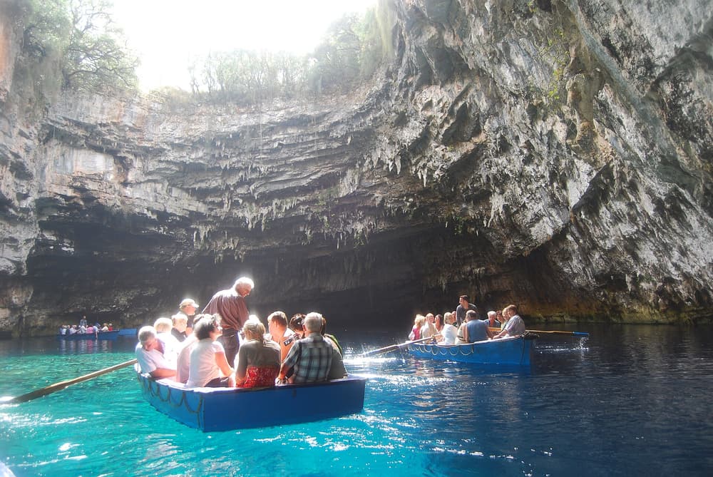
- Cave boat rides: At Melissani, west of Sami, boat tours run inside the cave.
These three kinds of Kefalonia boat tour cover separate waters around one island. Coastal routes follow the western shore, northern trips lead towards Ithaca, and the cave ride stays near Sami on the east coast. The next sections describe the ports, the west coast, Ithaca, the caves, the wildlife, the history and the best season.


Which ports does a Kefalonia boat tour leave from?
A Kefalonia boat tour can leave from Argostoli, Sami, Fiskardo or Agia Efimia. Argostoli is the capital and largest port, Sami is a major port on the east coast, Fiskardo is the northernmost port, and Agia Efimia is a small fishing harbour.
Argostoli has been the capital of Kefalonia since 1757. The town stands on a sheltered bay, and its port stretches one kilometre around the water. The port has room for about 100 small boats and is the largest on the island, with ferries to Zante and to Lixouri across the bay. A Kefalonia boat tour from Argostoli starts in the administrative centre of the island.
Sami lies on the central east coast and is a major port, with links to Patras and Ithaca. The town is the seat of the Sami municipality, one of three on the island since 2019. West of the town is the Melissani Cave, where boat tours are offered. A Kefalonia boat tour from Sami therefore starts on the east coast.
Fiskardo is the northernmost port of Kefalonia, a short distance from Ithaca, and ferries run from it to Frikes on Ithaca and to Lefkada. It lies 32 kilometres north of Argostoli and escaped the 1953 earthquake, so it kept its original architecture. Agia Efimia is a traditional fishing village on the east coast, centred on a small harbour. Its harbour is popular with sailing holidays.
- West: Argostoli, the capital, on a sheltered bay.
- East: Sami and Agia Efimia, both on the east coast.
- North: Fiskardo, 24 kilometres north of Sami.
Each port gives a Kefalonia boat tour a different first view: the bay at Argostoli, the cave near Sami, the fishing harbour at Agia Efimia and the short crossing to Ithaca from Fiskardo. In summer, a public bus to Myrtos Beach also departs from the harbour area in Agia Efimia, which links the east coast to the beaches of the north-west.
What does a Kefalonia boat tour see along the west coast?
A Kefalonia boat tour along the west coast sees Myrtos Beach and the cliffs behind it, the village of Assos with its Venetian castle, and the coast leading on towards the Paliki peninsula, the westernmost part of the island.
Myrtos Beach lies in the north-west of Kefalonia, between the feet of two mountains, Agia Dynati and Kalon Oros. The beach is made of round, white cobblestones, and the surrounding sediment is marble. Waves carry the finest marble along the shore and give the water a turquoise shade. From a boat on the Ionian Sea, a Kefalonia boat tour sees the whole curve of the shore.
Assos is a village on the west coast, 36 kilometres north of Argostoli. It was founded under Venetian rule and served as the administrative capital of northern Kefalonia from 1593 onwards. The Venetian Senate commissioned the engineer Marino Gentilini to build Assos Castle between 1593 and 1595, and it is one of the largest castles in Greece. The castle was never adopted as a fortress.
The coast then leads towards the Paliki peninsula, the westernmost part of Kefalonia. On its east side, the Gulf of Argostoli separates the peninsula from the rest of the island. Mountains up to 500 metres cover the western and northern parts of Paliki. Lixouri was the seat of its municipality. A Kefalonia boat tour along this shore passes the western edge of the island.
- Myrtos: A bay of white cobbles and turquoise water.
- Assos: A village with a Venetian castle, 36 kilometres north of Argostoli.
- Paliki: The westernmost peninsula, with Mania beach, Xi Beach and Vatsa Bay.
Together, Myrtos Beach, Assos and Paliki mark the western side of the island, from the north-west to the peninsula in the far west. A Kefalonia boat tour on this side runs along the Ionian Sea coast, while the next sections turn to Ithaca, the caves, the wildlife, the history and the best season.
Why does a Kefalonia boat tour cross to Ithaca?
A Kefalonia boat tour crosses to Ithaca because the island lies across the Strait of Ithaca from the northeast coast of Kefalonia. Homer’s Odyssey names Ithaca as the home of Odysseus, and its capital, Vathy, stands in a deep natural harbour.
Ithaca lies east of the northeast coast of Kefalonia, and the Strait of Ithaca separates the two islands. Sami, a major port of Kefalonia, has ferry links to Ithaca, and so does Fiskardo, the port in the north. A Kefalonia boat tour that heads across the strait enters waters that the ferries from both ports already serve, with Ithaca ahead.
Vathy is the largest settlement on Ithaca and the seat of its regional unit. The town took shape in the 16th century, under late Venetian rule, when families moved down from the old settlement of Palaiochora. In 1807 the French built a fortress on Loutsa hill, at the entrance to the port. The dockyard built over 200 ships in the 19th century.
The 1953 Ionian earthquake devastated Vathy, and the town was rebuilt gradually in the original Venetian style. A law passed in 1978 protects the architectural heritage of the town and requires the style and colour of every repair and new building to be preserved. The harbour town that a Kefalonia boat tour reaches on Ithaca therefore keeps its original Venetian look.
- Isthmus: Aetos, an isthmus just 600 metres wide, joins the two halves of Ithaca.
- Inscription: A 3rd-century BC inscription names a hero-shrine of Odysseus and games called the Odysseia.
- Peak: Nirito, the tallest mountain on Ithaca, rises to 806 metres in the north.
The debate over Homer’s island also touches the neighbours of Kefalonia. Wilhelm Dörpfeld backed Lefkada, and the Lefkada boat tour post follows that case. Another proposal placed Homer’s Ithaca on Paliki, a peninsula of Kefalonia, but geological evidence refutes it. Modern scholars accept Ithaca itself, the island that a Kefalonia boat tour crosses to, as Homer’s island.
Which caves does a Kefalonia boat tour reach?
A Kefalonia boat tour reaches two caves near Sami: Melissani, a cave lake that visitors cross in a small boat, and Drogarati, a cave close to the village of Karavomylos. Both rank among the important natural features of Kefalonia.
Melissani is a cave and cenote on Kefalonia, northwest of Sami. A cenote is a sinkhole that exposes groundwater, and here a collapse of limestone bedrock uncovered the water. A lake fills the floor, and forest surrounds the opening. A vertical shaft leads down to the water table, where a round trip is made in a small boat, the way a Kefalonia boat tour sees the lake.
In Greek mythology, Melissani was the Cave of the Nymphs. The water is brackish, a mix of fresh water that seeps in from inland and sea water that enters deep below the island. Stones cover the lake bottom, and plants grow at the opening of the cave. One description says the water is so clear that boats seem to float on air.
Drogarati lies in the same part of Kefalonia. Karavomylos, a fishing village on the coast, sits near both Drogarati and Melissani, and both caves are tourist attractions on the island. Melissani Lake, the Drogarati caves and the Koutavos Lagoon in Argostoli are all named as important natural features. A Kefalonia boat tour to the caves covers two of those three.
- Katavothres: Near Argostoli, sea water enters sinkholes called katavothres and is expelled in the bay of Sami.
- Fridi beach: The groundwater of Melissani flows out at Fridi beach.
- Divers: Speleo-divers have explored huge karst conduits in the area.
Karavomylos lies on the coast, 2 km west of Sami, 6 km southeast of Agia Effimia and 15 km northeast of Argostoli. Melissani sits about 5 km southeast of Agia Effimia, beside the road that links Sami with that village. The caves and Sami therefore belong to one stretch of coast, which a Kefalonia boat tour covers.
Which wildlife does a Kefalonia boat tour see?
A Kefalonia boat tour looks for loggerhead sea turtles, which nest on the south coast and swim in Argostoli harbour. A small population of endangered Mediterranean monk seals lives around the island, and dolphins belong to the sea life of the Ionian Sea.
The loggerhead sea turtle, Caretta caretta, is the best-known animal of Kefalonia. The island has an endangered loggerhead population that nests on beaches along the south coast. Turtles are also seen in the waters of Argostoli harbour and in the Koutavos Lagoon, and from De Bosset Bridge. A Kefalonia boat tour that sails near Argostoli covers that part of their range.
The Mediterranean monk seal, Monachus monachus, is endangered, and a small population lives around the coast of Kefalonia. The seals live especially on stretches of coast that people cannot reach because of the terrain. Caves there are ideal places to give birth and nurse pups. The best-known breeding site is a cave on Foki beach, on the north-east coast near Fiskardo.
Dolphins complete the wildlife list of a Kefalonia boat tour. A 2020 study found that one lineage of the common bottlenose dolphin is native to the Mediterranean, and the Ionian Sea is an elongated bay of that sea. The common dolphin also held cultural significance in antiquity, since it frequently appeared in Greek and Roman art, such as murals created by the Minoan civilization.
- Turtle diet: Loggerheads are omnivorous and feed mainly on bottom-dwelling invertebrates.
- Turtle habit: Loggerheads rarely come ashore, except for the brief nesting visits of females.
- Seal range: Remaining monk seal populations include southwestern Turkey and the Ionian Sea.
In Homer’s Odyssey, the sea god Proteus is shown herding monk seals for Poseidon, so the seal belongs to the same epic that makes Ithaca famous. A Kefalonia boat tour thus joins the myth of Odysseus with living animals of the same coast. Turtles, seals and dolphins share one sea, the Ionian Sea, in which Kefalonia lies.
What history does a Kefalonia boat tour recall?
A Kefalonia boat tour recalls Venetian rule from 1500 to 1797, a British protectorate that ended in 1864, the 1953 earthquake that flattened almost every settlement and the 1943 Acqui Division massacre. Fiskardo, in the far north, is the one village the earthquake left untouched.
A Spanish-Venetian army captured Cephalonia in 1500, and the island stayed in the Venetian Republic until 1797. From the 16th to the 18th centuries it exported currants. Britain blockaded the Ionian Islands in 1809, and the Treaty of Paris in 1815 made them a British protectorate. Colonel Charles Philippe de Bosset is credited with public works, including the bridge over the bay of Argostoli that now carries his name.
Four earthquakes hit the island in August 1953. The third, on 12 August, measured 6.8 on the moment magnitude scale and raised the entire island by 60 centimetres. Almost every settlement was destroyed, and the majority of the population left soon after. Fiskardo has a harbour with links to Lefkada and Ithaca, so a Kefalonia boat tour reaches the one village that stayed untouched.
The Italian Acqui Division was the island garrison in 1943, with 11,500 soldiers and 525 officers. After the armistice in September 1943, the Italians resisted German disarmament, and the last of them surrendered on 22 September. 1,315 Italians died in the battle, 5,155 were executed by 26 September, and 3,000 drowned when Allied forces sank German ships carrying survivors.
- Hilltop towns: Towns and villages stood high on hilltops to guard against pirate raiders.
- Roads: The British built the first larger roads on the island in the 19th century.
- Memorial: The Presidents of Greece and Italy commemorate the massacre at the Acqui Division monument.
Venetian currant exports, British roads, a wartime massacre and an earthquake all shaped the island. The De Bosset Bridge and the Acqui monument show that record today. A Kefalonia boat tour covers the coast of an island where almost every settlement fell in 1953 and the events of 1943 are still commemorated.
When is the best season for a Kefalonia boat tour?
A Kefalonia boat tour suits the dry summer months, when sun is steady and rain is rare on the island. Argostoli records 6.0 millimetres of rain in July, against 147.3 millimetres in November, so the wet months fall in autumn and winter.
Under the Koppen scheme, Kefalonia falls in class Csa, a Mediterranean type with hot summers, and Csa is the predominant class in Greece, found across the Ionian Islands. Summer brings bright, dry days, and the little rain that falls comes as passing showers or thunderstorms. Winters are wet, and the western areas of this climate zone receive more rain, so a Kefalonia boat tour belongs to the summer months.
Argostoli shows how sharp the change is. July has 0.8 days of rain on average, and December has 15.4. The average August high is 29.9 degrees Celsius and the low is 21.4. In January the high falls to 14.5 degrees and the low to 8.5. For a Kefalonia boat tour, the driest and warmest days fall in July and August.
The etesian winds, or meltemia, last until October and blow with the greatest frequency in July and August. Over the Aegean Sea the same winds hold down both temperatures and the daily swing between day and night, while the Ionian Sea and mainland Greece run warmer. Heatwaves still occur in Greece, but at the shoreline a cooler sea and its breeze soften them.
- Humidity: Argostoli averages 63.9 percent humidity in July and 74.6 percent in November.
- Ferries: The Lixouri ferry runs twice an hour in summer and once an hour in winter.
- Buses: Transit buses between the airport and Argostoli run only in the summer season.
In the Argostoli record, June, July and August carry the lowest rainfall, at 8.6, 6.0 and 9.4 millimetres. July and August also hold the etesian peak. A Kefalonia boat tour in that window meets dry, sunny weather, while the wet season runs from autumn into winter, and November and December record the highest rainfall.
What do travelers ask about a Kefalonia boat tour?
A Kefalonia boat tour prompts practical questions about how to reach the island, what Mount Ainos is, how large the population is and whether the next island fits in. Kefalonia ranks sixth in size among Greek islands and first among the Ionian Islands.
How is the island reached for a Kefalonia boat tour?
Kefalonia Island International Airport lies about 10 kilometres south of Argostoli. Scheduled flights run mainly to and from Athens, and charter flights arrive from all over Europe in summer. By sea, Sami links to Patras and Ithaca, Argostoli to Zakynthos and Lixouri, and Fiskardo to Lefkada and Ithaca.
What is Mount Ainos for a Kefalonia boat tour?
Mount Ainos is the tallest mountain on the island, at 1,628 metres. Much of the range is a national park covered with Greek fir and black pine, and semi-wild ponies live in the forest. On clear days the summit view includes Zakynthos, Lefkada and Ithaca.
How populated is the island of a Kefalonia boat tour?
The 2011 census counted 35,801 residents. The island covers 773 square kilometres, with 55 people per square kilometre, and Argostoli holds one-third of the inhabitants. The population was 70,000 in 1896, fell after the 1953 earthquake, and has stayed between 35,000 and 42,000 since.
Can a Kefalonia boat tour pair with a boat tour on Zakynthos?
Zakynthos lies 15 kilometres south of Kefalonia, and a ferry joins Argostoli to the village of Agios Nikolaos on Zakynthos. The Bay of Laganas is the prime nesting area for loggerhead sea turtles in the Mediterranean, so a Zakynthos turtle boat tour fits as a second trip on the next island.
Featured photo: Piet Horden, CC BY-SA 3.0, via Wikimedia Commons.