
A Corinth Canal tour visits the narrow sea channel cut through the Isthmus of Corinth, where steep rock walls drop to a strip of blue water between two gulfs. This post covers what a Corinth Canal tour includes, how the canal was built, the ancient attempts, the passage by boat, the bridges, Ancient Corinth, Acrocorinth and Isthmia, and the best season. More Greece tours are listed on the Greece VIP homepage.
Each section ends with a Corinth Canal tour that can be booked online.
What does a Corinth Canal tour include?
A Corinth Canal tour visits the channel that joins the Gulf of Corinth and the Saronic Gulf across the Isthmus of Corinth. The cut separates the Peloponnese from the Greek mainland, and the visit is either a road-trip stop above the cliffs or a boat passage.
The Corinth Canal is a waterway in Greece that connects the Gulf of Corinth, on the Ionian Sea side, with the Saronic Gulf, on the Aegean Sea side. It was completed in 1893 and cuts through the narrow Isthmus of Corinth. That strip of land links the Peloponnese peninsula to the rest of Greece, so the canal effectively makes the peninsula an island. Every Corinth Canal tour is built around this single fact of geography.
The isthmus is a land bridge about 6.3 kilometres wide, and the ancient world knew it as the landmark that divided the Peloponnese from the mainland. The geographer Strabo recorded a stele there with two inscriptions, one facing east and one facing west, each naming the side on which a traveller stood. A Corinth Canal tour therefore stands on ground that ancient travellers already read as a border between two regions.
Two kinds of Corinth Canal tour exist. The first is a stop on a road trip from Athens, where the group looks at the cut from the crossings that span it. The second is a boat passage, in which a small vessel enters the channel at one end and sails between the vertical rock walls to the other. The canal is now of little economic importance and serves mainly as a tourist attraction.
- Setting: The canal crosses the Isthmus of Corinth, near the city of Corinth.
- Seas joined: The Gulf of Corinth lies to the west of the isthmus and the Saronic Gulf to the east.
- Road-trip stop: A visit on the way from Athens looks down on the channel from the bridges above it.
- Boat passage: This kind of Corinth Canal tour sails through the channel, between walls that rise straight from the water.
The remaining sections explain how the cut was dug, which rulers tried before the nineteenth-century engineers, and what each kind of visit involves, from the road stop to the boat passage. Every Corinth Canal tour rests on the same narrow strip of land that ships were once dragged across and that rulers repeatedly planned to dig.


How was the canal on a Corinth Canal tour built?
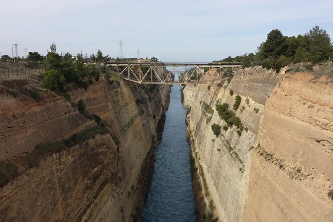
A Corinth Canal tour passes through a channel dug at sea level between 1882 and 1893. The first company ran out of money and went bankrupt, and a Greek company finished the work. The cut is 6.4 kilometres long, and its rock walls rise 90 metres.
The idea revived after Greece gained independence from the Ottoman Empire in 1830. The statesman Ioannis Kapodistrias asked a French engineer to assess the project, but the estimated cost of 40 million gold francs was too high for the new state. The opening of the Suez Canal in 1869 gave fresh impetus, and a law of 1870 authorised the work. A Corinth Canal tour passes the result of that law.
In 1881 a concession went to the Société Internationale du Canal Maritime de Corinthe, to build and run the canal for 99 years. King George I attended the formal start on 23 April 1882. The money problems behind a Corinth Canal tour began early: the company started with 30,000,000 francs, and after eight years of work the funds ran out. A bid to sell 60,000 bonds failed, as fewer than half were bought, and the company head István Türr went bankrupt, as did the company.
Work resumed in 1890 under a Greek company, and the canal was completed on 25 July 1893 after eleven years of effort. The rock is heavily faulted sedimentary stone in an active seismic zone, so landslides followed. Although the canal was formally opened in July 1893, it opened to navigation only in November 1894. Retaining walls later lined more than half of the channel, and between 1893 and 1940 repairs closed it for a total of four years.
- Length: The channel on a Corinth Canal tour is 6,343 metres long and has no locks.
- Width: The water is 24.6 metres wide at the surface and 21.3 metres wide at the bottom.
- Depth: The channel is 8 metres deep.
- Walls: The near-vertical rock sides rise 90 metres above sea level at an angle of 80 degrees.
The numbers explain why the canal looks so narrow from above. Large modern ships cannot fit through a channel only 24.6 metres wide, so it carries smaller vessels and tourist ships. For a Corinth Canal tour, that narrowness is the main attraction: the vertical walls, the straight line of the cut and the thin strip of sea at the bottom.
Which earlier attempts does a Corinth Canal tour recall?
A Corinth Canal tour recalls attempts that began with Periander in the 7th century BC and reached the ground under Nero in 67 AD. Periander built the Diolkos paved trackway instead of a canal, and Demetrius Poliorcetes, Julius Caesar and Caligula planned a cut but never dug.
The tyrant Periander of Corinth was the first to propose a cut through the isthmus, in the 7th century BC. He dropped the plan and built the Diolkos, a paved trackway along which ships were hauled from one side of the isthmus to the other. Accounts blame the great expense, a lack of labour, or a fear that a canal threatened Corinth’s role as a trading port. A Corinth Canal tour passes remnants of the Diolkos beside the modern channel.
Demetrius Poliorcetes planned a canal for his lines of communication, but his surveyors misjudged the sea levels and feared floods. Julius Caesar considered a canal, according to Plutarch and Suetonius, yet was assassinated before work began. Caligula ordered a study in 40 AD, and Egyptian experts wrongly reported that the Gulf of Corinth stood higher than the Saronic Gulf, which meant a flood for the island of Aegina. Caligula was assassinated as well, so a Corinth Canal tour recalls three plans that never reached the ground.
On a Corinth Canal tour, Nero is the first ruler whose crews actually dug. In 67 AD he broke the ground himself with a pickaxe and carried away the first basket of soil. A workforce of 6,000 Judean prisoners of war then dug trenches from both sides, while a third group drilled shafts in the ridge to test the rock. According to Suetonius, the cut reached four stades, about 700 metres, or a tenth of the distance across. The project stopped soon after Nero died.
- Periander: The 7th century BC tyrant proposed a canal and built the Diolkos instead.
- Demetrius Poliorcetes: His surveyors feared floods, and the plan ended.
- Julius Caesar: The dictator was assassinated before the project began.
- Caligula: The study of 40 AD wrongly warned of a flood on Aegina.
- Nero: The works began in 67 AD and stopped after his death.
Workers under Nero left a relief of Hercules, which can still be seen on the north side of the cutting at the Gulf of Corinth end, below an old bridge foundation. The modern canal follows the course that Nero’s crews dug. A Corinth Canal tour therefore links the nineteenth-century channel with every earlier attempt, from the Diolkos onward.
What does a Corinth Canal tour by boat see?
A Corinth Canal tour by boat travels the 6.4-kilometre channel cut through the Isthmus of Corinth at sea level. Near-vertical limestone walls rise 90 metres above sea level on both sides, and the lock-free channel links the Gulf of Corinth with the Saronic Gulf.
The cutting is the main sight of a Corinth Canal tour by boat. The channel is 24.6 metres wide at the surface, 21.3 metres wide at the bottom and 8 metres deep. The limestone faces stand at a near-vertical angle of 80 degrees. The rock is heavily faulted and sits in an active seismic zone, so the walls have been unstable from the start, and retaining walls now line the water’s edge along more than half of the canal’s length.
Size decides which vessels share the passage with a Corinth Canal tour. The canal accepts ships up to 24.6 metres wide with a draft of up to 7.3 metres, so large deep-drafted oceangoing vessels cannot enter. A cruise ship 22.5 metres wide and 195 metres long set the record for the longest ship to pass through, in October 2019. Vessels that do fit save a 700-kilometre journey around the Peloponnese.
Commercial traffic fell far short of the builders’ plans. The channel is narrow, the high walls funnel wind along its length, and the two gulfs have tides at different times, which creates strong currents. Operators were unwilling to use it, and the canal is now of little economic importance. Tourist ships are the main users, and a Corinth Canal tour joins around 15,000 ships a year. Convoys pass one at a time on a one-way system, and tugs tow larger ships.
- Walls: Limestone faces rise 90 metres above sea level at a near-vertical angle of 80 degrees.
- Channel: A Corinth Canal tour by boat covers 6.4 kilometres of water with no locks.
- Limits: The maximum ship width is 24.6 metres and the maximum draft is 7.3 metres.
- Traffic: Convoys run one way at a time, and tugs tow the larger ships.
Passing through the cutting gives a Corinth Canal tour by boat its clearest view of how the isthmus was cut. The route runs between two limestone walls, along a one-way channel with no locks, where tugs tow the larger ships. Tourist ships are now the main users of a waterway built for commercial cargo, and the Corinth Canal tour by boat is the way that history is still seen from the water.
Which bridges does a Corinth Canal tour pass?
A Corinth Canal tour passes beneath a railway line, a road and a motorway carried at a height of about 45 metres, plus two submersible bridges at sea level. The submersible bridges, at Isthmia and Poseidonia, sink below the water to let vessels through.
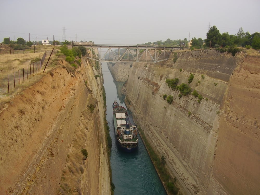
Three fixed crossings span the cutting. The canal is crossed by a railway line, a road and a motorway, all carried at a height of about 45 metres. A Corinth Canal tour passes under these spans while the limestone walls, which rise 90 metres above sea level, stand on either side. The cutting separates the Peloponnese peninsula from the Greek mainland, so these spans are what join the two sides.
The main bridge has a war history. On 26 April 1941, during the Battle of Greece, German parachutists and glider troops attacked the bridge, which British and Anzac forces defended and had wired for demolition. The charges went off and the structure was destroyed. A combined rail and road bridge replaced it. In October 1944, retreating German forces destroyed the bridges again and dumped locomotives and wreckage into the canal.
Two more crossings sit at sea level on a Corinth Canal tour. In 1988, submersible bridges were installed at each end of the canal, by the eastern harbour of Isthmia and the western harbour of Poseidonia, and they gave road traffic two additional ways across. A submersible bridge is a movable bridge that lowers its deck below the water to let vessels through. At these two bridges the centre span drops to 8 metres below water level, so nothing stands above the channel while a ship passes.
- Fixed spans: A railway line, a road and a motorway cross the canal at a height of about 45 metres.
- Isthmia: The submersible bridge at the eastern harbour carries road traffic at sea level.
- Poseidonia: The submersible bridge at the western harbour is the matching crossing at the other end.
- Centre span: On a Corinth Canal tour, each submersible bridge lowers its centre span to 8 metres below water level.
A Corinth Canal tour meets two kinds of crossing: high fixed bridges and low submersible ones. The submersible design leaves no structure above the shipping channel and so sets no height limit, which matters for sailing vessels. The sunken deck does limit the draft of vessels in the waterway, and draft is already capped in this canal at 7.3 metres.
Why does a Corinth Canal tour stop at Ancient Corinth?
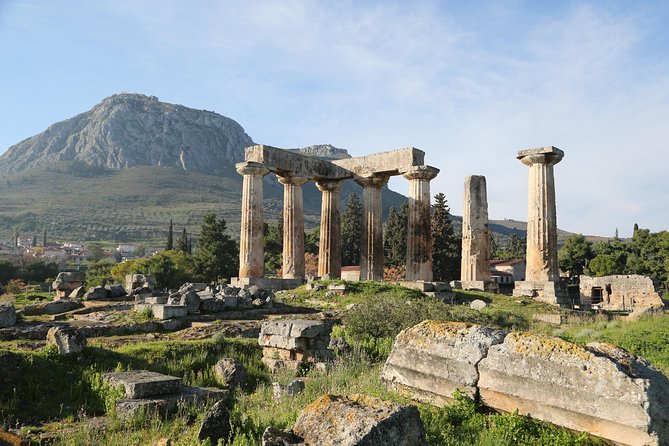
A Corinth Canal tour stops at Ancient Corinth because the ancient city stood on the same isthmus that the canal now cuts. The ruins hold a Temple of Apollo from the mid-6th century BC, a Roman city and sites linked to Saint Paul.
Corinth was a city-state on the Isthmus of Corinth, the narrow stretch of land that joins the Peloponnese peninsula to mainland Greece, roughly halfway between Athens and Sparta. It was one of the largest cities of Greece, with a population of 90,000 in 400 BC. All land traffic to the Peloponnese had to pass through the isthmus, which gave the city its wealth. The modern city lies about 5 kilometres northeast of the ancient ruins that a Corinth Canal tour visits.
The Temple of Apollo dates from the mid-6th century BC and is the dominating monument of the site. It is one of the only features of the ancient city that has stayed visible since antiquity. The American School of Classical Studies at Athens began excavating in 1896, and its main focus has been the area around the temple. Finds from the excavations are housed in the Archaeological Museum of Ancient Corinth.
The Romans demolished Corinth in 146 BC. Julius Caesar refounded it in 44 BC, and it later became the provincial capital of Achaea, with a mixed population of Romans, Greeks and Jews. Saint Paul first visited in AD 49 or 50, lived in the city for eighteen months and worked there as a tentmaker. A Corinth Canal tour that stops here covers the Roman layer of the site as well as the Greek one.
- Temple of Apollo: Built in the mid-6th century BC, it is the dominating monument of the excavated site.
- Roman city: Refounded by Julius Caesar in 44 BC, it became the capital of the province of Achaea.
- Saint Paul: Two of his epistles are addressed to the church of Corinth, which tradition says he founded.
- Museum: The Archaeological Museum of Ancient Corinth houses the finds from the excavations.
A Corinth Canal tour that adds Ancient Corinth links the engineering of the canal to the long history of the isthmus it crosses. Travellers who want further ancient sites on the Peloponnese can pair this stop with the Mycenae Epidaurus day trip, which covers other places in the same region of Greece.
What does a Corinth Canal tour see at Acrocorinth and Isthmia?
A Corinth Canal tour sees two ancient sites tied to the isthmus: the Acrocorinth fortress, a monolithic rock above Ancient Corinth, and Isthmia, the sanctuary of Poseidon known for the Isthmian Games. Acrocorinth once commanded the narrow neck of land that the canal now cuts.
Acrocorinth is a monolithic rock that overlooks the ancient city of Corinth. Its fortress served as a last line of defense in southern Greece, because the height commanded the Isthmus of Corinth and blocked foes from entering the Peloponnese by land. A secure water supply let defenders hold out. A Corinth Canal tour that adds Acrocorinth shows the military side of the same narrow neck of land that the canal later cut through.
People held the summit continuously from the archaic age until the early 1800s. In the Hellenistic period it formed one of three Macedonian-held strongholds known as the Fetters of Greece. The Byzantine Empire fortified it heavily and made it the seat of the strategos of the thema of Hellas, and later of the Peloponnese. Leo Sgouros defended it against the Crusaders for three years. Frankish, Venetian and Ottoman rulers each held it in turn, and three circuit walls formed its man-made defense.
Isthmia was an ancient sanctuary of Poseidon on the Isthmus of Corinth, between the Corinthian ports of Lechaeum on the Gulf of Corinth and Cenchreae on the Saronic Gulf. It lay on the key land route that joined Athens and central Greece to Corinth and the Peloponnese. Poseidon, god of the sea and of sailors, suited that spot between two seas. A Corinth Canal tour that stops at Isthmia meets the same crossing point from the ancient side.
The Isthmian Games were one of the Panhellenic Games of ancient Greece. The festival offered athletic and musical contests in honor of Poseidon, held in the spring of the second and fourth years of each Olympiad. Winners first received a wreath of celery, and later a wreath of pine. In 196 BC the Roman general Titus Quinctius Flamininus used the festival to proclaim that the Greek states were free from foreign garrisons.
- Acrocorinth: A monolithic rock above Ancient Corinth, ringed by three circuit walls.
- Upper Pirene: A spring that lies inside the encircling walls of the fortress.
- Temple of Poseidon: The archaic temple at Isthmia was built in the Doric style and was badly burned in a fire in 480 BC.
- Stadia: Excavators found two stadia at Isthmia, an Early Stadium and a Late Stadium.
The Acrocorinth site and the Isthmia sanctuary give a Corinth Canal tour an ancient frame for a modern cut. Oscar Broneer found the Isthmia site in 1952 and led University of Chicago excavations that uncovered the temple, the theater and the two stadia. The Early Stadium keeps a well preserved starting line beside sixteen lanes. The American School’s Corinth Excavations began work on Acrocorinth in 1929.
When is the best season for a Corinth Canal tour?
A Corinth Canal tour runs in a hot-summer Mediterranean climate, so the season sets the heat and the rain. Corinth averages 28.7 °C in July and 9.1 °C in January, and spring and autumn sit between those two averages, with milder days than midsummer.
The nearby weather station at Velo, run by the Hellenic National Meteorological Service, records a hot-summer Mediterranean climate for Corinth. Summers are hot and dry, and winters are cool and rainy. July is the hottest month, with an average temperature of 28.7 °C, and January is the coldest, at 9.1 °C. Those numbers describe the weather that a Corinth Canal tour meets on the open cutting and on the hilltop sites.
Greece as a whole has a predominantly Mediterranean climate. In the low-lying parts of the Peloponnese, summer weather is frequently sunny and dry, and any rain falls as showers or thunderstorms. Winters are wet, and snow that falls does not last long, especially on south-facing slopes. Coastal heatwaves tend to be milder, because the cooler sea and the sea breeze moderate temperatures. Heat can still reach extremes: in July 2023 the World Meteorological Organization station at Gytheio in the Peloponnese registered 46.4 °C.
The etesian winds, also called meltemia, can blow from late spring to October, with the highest frequency in July and August. A Corinth Canal tour in spring follows an older link with the isthmus, since the ancient Isthmian Games fell in the spring of the second year of each Olympiad. On the coast of Corinthia, summers are hot and winters are mild, while the mountainous areas of the regional unit have somewhat colder winters with snowfalls.
- Summer: Hot and dry, with showers or thunderstorms in place of steady rain.
- Winter: Cool and rainy, with snow that does not last long on south-facing slopes.
- Rainfall: About 463 mm of rain falls on Corinth in a year.
- Average: The temperature over the whole year is 18.1 °C.
The cutting, the fortress rock and the sanctuary site all lie in the open air, so weather shapes a Corinth Canal tour more than it shapes an indoor visit. The heat of July, the rain of the cool months and the etesian winds of late spring to October set the conditions on the day. Spring and autumn sit between those extremes, with the same sites open to the sky.
What do travelers ask about a Corinth Canal tour?
A Corinth Canal tour raises practical questions about distance, roads, nearby towns, the regional unit and a second trip from Athens. Corinth lies about 78 kilometres west of Athens, and the canal cuts the isthmus about 4 kilometres east of the city, inside the regional unit of Corinthia.
How far is a Corinth Canal tour from Athens, and which motorway leads there?
Corinth is about 78 kilometres west of Athens, and the canal lies about 4 kilometres east of the city. The A8/E94 toll motorway runs from Athens to Corinth. Corinth is the main entry point to the Peloponnese, so the road for a Corinth Canal tour is also the road into the peninsula.
What is Loutraki on a Corinth Canal tour?
Loutraki is a seaside resort town on the Gulf of Corinth, 81 kilometres west of Athens and 8 kilometres northeast of Corinth. It is known for natural springs and therapeutic spas, and its name refers to the Greek word for bath. Loutraki belongs to Corinthia but lies northwest of the canal, so it stands outside the Peloponnese.
Which regional unit is a Corinth Canal tour in?
The canal lies in Corinthia, a regional unit of the Peloponnese region, set around the city of Corinth in the north-eastern part of the peninsula. Corinthia borders Attica to the north and the Saronic Gulf to the east. A Corinth Canal tour in Corinthia sits among attractions such as Ancient Corinth, Acrocorinth and the thermal springs of Loutraki.
Can a Corinth Canal tour pair with a Delphi day trip from Athens on another day?
Yes, the two outings fit separate days. A Corinth Canal tour heads west to the isthmus, while a Delphi day trip from Athens reaches the sacred precinct on Mount Parnassus. The ancient Isthmian Games fell in the second and fourth years of an Olympiad, and the Pythian Games at Delphi in the third.
Featured photo: Berthold Werner, CC BY-SA 3.0, via Wikimedia Commons.