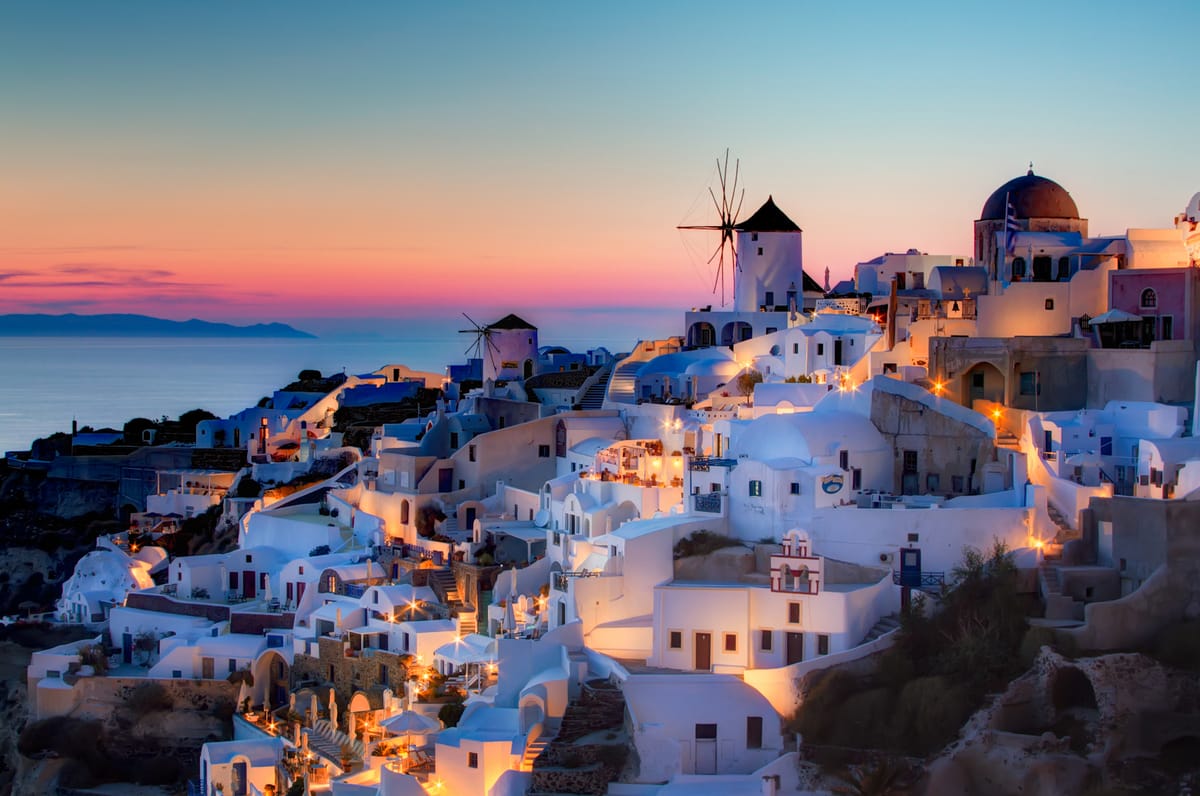
A Santorini sunset tour follows the evening light over the caldera of Santorini, from the cliff-top villages on the west side of the island or from a boat on the water below. This post covers what a Santorini sunset tour includes, Oia, the other viewpoints, the sunset by boat, how the caldera formed, the architecture, the history along the route and the best season. More tours in Greece are listed on the Greece VIP homepage.
Each section ends with a Santorini sunset tour that can be booked online.
What does a Santorini sunset tour include?
A Santorini sunset tour takes visitors to the western side of the island, where whitewashed villages stand on the rim of a caldera. It runs by road between cliff-top viewpoints or by boat across the caldera, and both end with the sun setting over the water.
Santorini, officially Thira or Thera, is a Greek island in the southern Aegean Sea. It is the southernmost of the Cyclades and the largest island of a circular archipelago. That ring of islands formed around the Santorini caldera, so every Santorini sunset tour rests on one fact of geography: the western edge of the island drops in cliffs to a crater filled by the sea.
The caldera measures about 12 by 7 kilometres and has steep cliffs 300 metres high on three sides. The islands of Nea Kameni and Palea Kameni, both small and volcanic, lie close to the middle of the water. Whitewashed villages are draped over the high walls. A Santorini sunset tour uses this setting, because the villages on the western rim look out over the water and the volcanic islands.
Two kinds of Santorini sunset tour exist. A road tour links villages and viewpoints on the caldera rim, with stops on foot between whitewashed houses. A boat tour starts from a harbour and sails inside the caldera, which shows the cliffs, the villages and the volcanic islands from sea level. The choice changes the angle of the view, not the direction of the sunset.
- Caldera: Cliffs 300 metres high enclose the water on three sides.
- Road routes: Stops link the rim villages and the hilltop castle ruins on the western side.
- Boat routes: Cruises sail inside the caldera and are available from both Oia and Fira.
A Santorini sunset tour therefore combines geography and timing: a ring-shaped island, a cliff wall 300 metres high and open water to the west. The next sections name the stops in turn, starting with Oia and the other rim viewpoints, and then cover the boat option, the caldera, the architecture, the history and the best season.


Why is Oia the classic stop on a Santorini sunset tour?
A Santorini sunset tour reaches Oia because the village stands on the northwestern edge of the island, on the caldera rim, with views of the sunset over the water. Watching the sunset is a popular attraction there, and crowds gather every evening.
Oia, also written Ia, covers the whole island of Therasia and the northwesternmost part of Santorini. The village extends for almost two kilometres along the northern edge of the caldera, about 11 kilometres from Fira. From that edge the volcanoes of Palea Kameni and Nea Kameni come into view. For that reason a Santorini sunset tour treats Oia as the classic evening stop.
Oia is built on the steep slope of the caldera. Houses and restaurants sit in niches carved into the rock on the seaward side, linked by narrow passageways. The cave houses were used by ship crews, and the wealthy captains of the late 19th century built neo-classical mansions, one above the other. Air-filled pumice around the dwellings keeps them warm in winter and cool in summer.
At the highest point of the village stand the ruins of a castle, also called Fort Londsa. It was the seat of the Argyri family under the Venetians and now gives a Santorini sunset tour a lookout with a full 360-degree view. Below the village, steep stairs lead down to Ammoudi, the harbour on the western side, where the ferry to Therasia leaves. The descent to the port is 300 steps.
- Position: The village covers the northwesternmost part of Santorini, on the northern edge of the caldera.
- Castle: The ruined fortress at the highest point gives a 360-degree lookout.
- Crowds: The village fills with people every evening, and its narrow paths become congested in the tourist season.
Oia holds its place on a Santorini sunset tour for three reasons: its position on the caldera rim, its cliff architecture and its castle lookout. Sunset viewing is a popular attraction of the village each evening, as the white houses and the caldera catch the colours of the setting sun. The next section moves to the other rim viewpoints.
Which other viewpoints does a Santorini sunset tour use?
A Santorini sunset tour also uses Fira, Imerovigli with the Skaros rock, Pyrgos and the Akrotiri lighthouse. Fira, Imerovigli and Akrotiri look across the caldera, while Pyrgos stands on a hill with views in almost every direction and the lighthouse marks the western tip of the island.
Fira is the modern capital of Santorini, a town of whitewashed houses on the edge of the caldera on the western side of the island. From Fira a Santorini sunset tour has a panoramic view of the whole caldera, which is 18 kilometres long from Cape Akrotiri in the south to Cape Agios Nikolaos in the north. The central bus station is also in Fira, with buses to almost every part of the island.
Imerovigli lies north of Fira, built on the rim of the caldera and crossed by narrow, paved paths. Its churches follow the Cycladic style, and the Monastery of Saint Nikolaos stands on the path that connects the village with Fira. Beside the village rises Skaros Rock, which carries the remains of a Venetian castle built in 1207 by Marco Sanudo, then ruler of all the Cyclades.
Pyrgos Kallistis lies about 7 kilometres from Fira, on a hill built like an amphitheatre, where the ruins of a Venetian castle once served as the administrative centre of the island. Akrotiri lies 15 kilometres south of Fira, on a hill that looks out over the caldera cliffs, with the ruins of a 13th-century fortress at its core. West of Akrotiri, on the westmost tip of Santorini, a lighthouse dating from 1892 gives a Santorini sunset tour its far western point.
- Fira: The capital offers a panorama of the whole caldera and holds the main bus station.
- Imerovigli: The rim village stands beside Skaros Rock and its Venetian castle ruins.
- Pyrgos: A hill village with narrow medieval lanes and views in almost every direction.
These stops give a Santorini sunset tour a choice of angles on the same caldera. Fira offers the panorama, Imerovigli the rim path and Skaros Rock, Pyrgos the hilltop castle and Akrotiri the western tip with its lighthouse. Oia fills with people at sunset, and these villages give the same light from other places.
What does a Santorini sunset tour by boat see?
A Santorini sunset tour by boat takes in the flooded caldera from its centre: the dark lava islands of Nea Kameni and Palea Kameni, the larger island of Therasia, the pale islet of Aspronisi and the tall cliffs of the main island rising from the water.
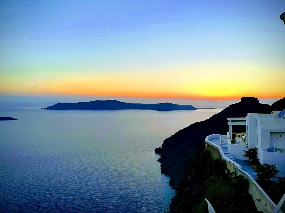
Nea Kameni sits near the middle of the flooded caldera, so it fills the foreground of a Santorini sunset tour by boat. The name means new burnt, because eruptions of dacite lava and ash built the island. It is nearly round, about 2 kilometres across, with a crater that rises 130 metres. Scientists monitor it, and it is a protected scientific site.
Palea Kameni lies to the southwest of Nea Kameni and is the smaller, older partner on a Santorini sunset tour. Its name means Old Burnt Island. A small church and a herd of goats are on the island, and sparse succulent plants cover it. The island has a hot spring, and thermal water in the caldera is warmer than the surrounding sea.
Therasia lies northwest of Nea Kameni and is the second largest island of the group. The Thera eruption separated it from the main island, and 249 residents lived there at the 2021 census. Aspronisi means White Island, named for its white pumice. The islet is 650 metres long and 200 metres wide, with steep cliffs and a base of black lava rock.
From the water, the caldera wall is the largest feature of a Santorini sunset tour. The caldera measures about 12 by 7 kilometres, and steep cliffs 300 metres high enclose it on three sides. The inner coast shows layers of solidified lava stacked on top of each other, with the main towns on the crest, and whitewashed villages drape the walls.
- Nea Kameni: The island covers 3.4 square kilometres at the centre of the caldera.
- Therasia: The island covers 9.3 square kilometres at the periphery.
- Aspronisi: The islet covers 0.1 square kilometres, also at the periphery.
The islands and the cliff wall form one ring around the water, with the Kameni islands in the middle and Therasia and Aspronisi at the edge. A Santorini sunset tour by boat sees that ring from inside. The same islands appear on a Santorini catamaran cruise, which has its own page.
How did the caldera seen on a Santorini sunset tour form?
A Santorini sunset tour shows the caldera that the Minoan eruption formed about 3,600 years ago, when the volcano collapsed into a roughly circular basin that the sea then filled. Older eruptions had already left overlapping calderas, so the present basin is the latest of a series.
The caldera on a Santorini sunset tour is the result of repeated cycles. The volcano erupted, collapsed into a roughly circular basin filled by seawater, then slowly refilled with magma and built a new volcano. Over the past 360,000 years there were two major cycles, each ending in two caldera-forming eruptions. Before the Minoan eruption, the walls formed a nearly continuous ring of islands.
The Minoan eruption took place around 1600 BC and rated 7 on the Volcanic Explosivity Index. Its eruption column was 30 to 35 kilometres high and reached the stratosphere. Studies have identified four major phases. The third began the collapse of the caldera, and the fourth completed it and produced megatsunamis. A Santorini sunset tour crosses the basin that this collapse left.
The cliffs record it in layers. White tephra up to 60 metres thick lies over the old ground level, in three bands for the phases of the eruption, and the inner coast shows stacked layers of solidified lava. Later eruptions built the Kameni islands seen on a Santorini sunset tour: an undersea volcano broke the surface in 1707, and the last small eruption was in 1950.
- Southern caldera: The oldest of the series formed about 180,000 years ago.
- Cape Riva caldera: This caldera was created about 21,000 years ago.
- Minoan caldera: The current caldera formed about 3,600 years ago.
The ring of cliffs, the layered walls and the black Kameni islands are one record of repeated build-up and collapse. The Kameni islands are the newest part of that record, formed since the Minoan eruption. Santorini is dormant, yet it remains an active volcano, and a Santorini sunset tour crosses that record from the water.
What architecture does a Santorini sunset tour show?
A Santorini sunset tour shows cave houses dug into the pumice, low whitewashed cubic houses, blue-domed churches, an old windmill and the two-storey captains’ houses of Oia. Each type follows from the volcanic ground, the traditions of the Cyclades or the sea trade of the village.
The cave houses grow out of the volcanic ground. Houses on Santorini extend sideways or downwards into the surrounding pumice, and the extra rooms are called hypóskapha. Air held in the pumice gives high insulation, so the rooms stay cool in summer and warm in winter. In Oia, cave houses are carved into the rock face on top of the cliff.
The cubic houses follow the traditions of the other Cyclades. A Santorini sunset tour sees them low on the crest, built of local stone and whitewashed or limewashed. Volcanic ashes were used as colours, and in recent years these colours tend to replace white on house façades. This style developed until the great earthquake of 1956, which destroyed half of the island’s buildings.
Oia shows the other forms together. The village faces the sunset over the caldera, so its buildings are the main architecture on a Santorini sunset tour. It has whitewashed, blue-domed churches and an old windmill that appears on postcards. Sea trade to Alexandria and Russia built the wealth of the village, and the two-storey captains’ houses on its highest part remain as a reminder.
- Cave houses: These rooms are dug into the pumice for insulation.
- Cubic houses: These houses are low and made of local stone.
- Blue-domed churches: The churches of Oia are whitewashed with blue domes.
- Captains’ houses: These houses have two storeys.
The architecture of the caldera wall follows the ground it stands on. Pumice gave the cave rooms their insulation, local stone gave the houses their walls, and sea trade paid for the captains’ houses. A Santorini sunset tour shows all of these forms along one cliff line, from the cave houses cut into the rock to the blue domes of the churches.
What history does a Santorini sunset tour pass?
A Santorini sunset tour passes three layers of history: Akrotiri, a Bronze Age town buried under volcanic ash, Ancient Thera on the limestone hill of Mesa Vouno, and the Venetian-era castle settlements called kastelia, including the one at Oia.
Akrotiri is a Cycladic Bronze Age settlement on Santorini. The earliest evidence of life there reaches back to the fifth millennium BCE, when it was a small fishing and farming village. From about 2000 to 1650 BC it grew into one of the major Bronze Age ports of the Aegean, with objects arriving from Crete, Anatolia, Cyprus, Syria and Egypt. The Theran eruption of the 16th century BC then buried the town in volcanic ash, and excavation has run since 1967.
Ancient Thera stands on the limestone hill of Mesa Vouno, 396 metres above sea level, where Dorians founded the main Hellenic city in the ninth century BC. A street almost 800 metres long ran through it, and its buildings were made of local limestone. The theatre, built into the slope, seated about 1,500 people. A small eruption covered the city in pumice in the year 726, and it was given up. It is the site on a Santorini sunset tour that belongs to the Dorian period.
In the 15th and 16th centuries, pirates threatened the Cyclades, so islanders built their settlements on the highest, least accessible ground. The kastelia were large fortified villages, and Santorini had five of them: Agios Nikolaos at Oia, Akrotiri, Emborio, Pyrgos and Skaros. Venice annexed the island in about 1335, and the Ottoman admiral Piyale Pasha captured it in 1576. A Santorini sunset tour that reaches Oia meets the village of the Agios Nikolaos kasteli.
- Frescoes: The wall paintings of Akrotiri kept their original colour well because thick volcanic ash sealed them.
- Drainage: The pipes with running water found at Akrotiri are the oldest such utilities discovered.
- Evacuation: Only a single gold object and no human skeletal remains were found, which points to an orderly evacuation.
- Goulas: Four towers called goulas served the islanders as observatories and as places of refuge.
A Santorini sunset tour that reaches these sites covers a long stretch of island history. Akrotiri was lost to ash in the 16th century BC, Ancient Thera was given up after the pumice of the year 726, and the kastelia answered the pirate raids of the 15th and 16th centuries. Venice and the Ottomans then ruled the island in turn.
When is the best season for a Santorini sunset tour?
A Santorini sunset tour meets its driest weather in summer, because Santorini has dry summers and relatively wetter winters. The meltemi, a strong dry north wind, blows periodically through summer until about mid-September, and the island’s tourism industry centres on the same summer months.
The National Observatory of Athens classes Santorini as hot semi-arid, with Mediterranean features such as dry summers and relatively wetter winters. Average annual rainfall is around 270 mm, and the average annual temperature is around 19 degrees Celsius. Rain is concentrated in the wetter winters, so a Santorini sunset tour in summer runs in the dry part of the year.
The meltemi, also called the etesian wind, is a strong, dry north wind of the Aegean Sea. It blows periodically from late spring to mid-September and is strongest in the afternoon. A spell can last for days without a break. In the southern Aegean it blows from the northwest, and it can reach force 7 or 8 on the Beaufort scale. For a Santorini sunset tour by sea, yachts and inter-island ferries cannot always sail in such conditions.
Santorini’s primary industry is tourism, particularly in the summer months. That places the visitor peak in the same season as the dry climate and the meltemi. The months outside summer fall outside that peak and bring relatively wetter weather, which makes them the quieter choice for a Santorini sunset tour. The wind keeps its own calendar, however, and ends around mid-September.
- Summer: The climate is dry, the meltemi blows periodically, and tourism is at its peak.
- Winter: Winters are relatively wetter, and annual rainfall averages around 270 mm.
- Wind: Meltemi weather is ordinarily fine and clear, and the northerly winds temper the fierce summer heat.
- Spells: A run of meltemi days can last without a break, and the wind strengthens in the afternoon.
The best month for a Santorini sunset tour therefore balances three facts. Summer is dry, the meltemi blows through it until about mid-September, and tourism peaks in the same months. Winters are relatively wetter and fall outside the tourism peak, which leaves the wind as the one factor with a fixed seasonal window.
What do travelers ask about a Santorini sunset tour?
A Santorini sunset tour starts on a Greek island in the southern Aegean Sea, the largest island of a small, circular archipelago formed by the caldera. Travelers ask how to reach it, which group it joins, what its population is and whether a wine day fits.
How do travelers reach the island for a Santorini sunset tour?
Santorini is linked by ferry with Piraeus every day of the year, with up to five direct crossings in summer. Athinios is the ferry port, and Skala is the old port where cruise ships anchor. A major airport lies about 6 km southeast of downtown Thera. These links serve every Santorini sunset tour.
Which island group does a Santorini sunset tour visit?
Santorini is the southernmost member of the Cyclades group of islands, about 200 km southeast of the mainland. The municipality covers the inhabited islands of Santorini and Therasia and the uninhabited Nea Kameni, Palaia Kameni, Aspronisi, Anydros and Christiana. Together they form the circular archipelago around the caldera.
What is the population of the island behind a Santorini sunset tour?
Santorini had 15,480 residents at the 2021 census. In 1954 it had about 12,000 inhabitants, and the only transport was a jeep, a small bus, donkeys and mules. Tourism has since lifted the economy and the population, and an estimated 2 million tourists visit each year.
Can a Santorini sunset tour pair with a Santorini wine tour on another day?
Yes. Santorini covers about 73 km2, and buses from Fira reach almost all places on it, so two outings fit on separate days. The island sustains a wine industry built on the indigenous Assyrtiko grape, and a Santorini wine tour follows that story, while a Santorini sunset tour follows the caldera.
Featured photo: Pedro Szekely, CC BY-SA 2.0, via Wikimedia Commons.