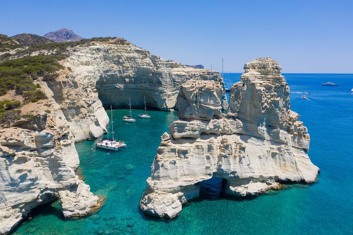
A Milos boat tour sails around the volcanic island of Milos in the south-west Cyclades, to sea caves, white rocks and beaches that are best seen from the water. This post covers what a Milos boat tour includes, Kleftiko, the ports, the beaches, the volcanic rocks and mines, the history, Sykia, Papafragas, the Glaronisia, the fishing villages, the Kastro, the ancient theatre, the museum, the south coast, the wildlife, Polyaigos and Kimolos and the best season. More Greece tours are listed on the Greece VIP homepage.
Each section ends with a Milos boat tour that can be booked online.
What does a Milos boat tour include?
A Milos boat tour includes a sea view of a volcanic Greek island in the Aegean Sea, the Cyclades island furthest to the south-west. The route follows a rugged coast, a natural harbour set in an old crater and caves on the south coast.
Milos is a volcanic Greek island in the Aegean Sea, just north of the Sea of Crete. It sits 120 kilometres due east of the coast of Laconia and forms the south-western edge of the Cyclades. The island measures about 23 km from east to west and 13 km from north to south, with an area of about 151 square kilometres. A Milos boat tour works around this compact outline, which keeps the main stretches of coast close to one another.
The greater part of Milos is rugged and hilly. The highest point is Mount Profitis Elias, 748 metres high, in the west. Almost all of the uninhabited western region is a Natura 2000 site, home to over 800 different taxa, 35 of them endemic to Greece. A Milos boat tour along the western shore passes this protected, empty land, where the hills meet the sea without towns above them.
The centre of the island holds its natural harbour, which is the hollow of the main crater. This bay cuts in from the north-west and divides Milos into two fairly equal parts. The two halves are joined by an isthmus no more than 2.2 km broad. Every Milos boat tour that starts in the harbour crosses this crater bay first, so the trip begins inside the old volcano itself.
Beyond the main coast, the municipality of Milos also takes in the uninhabited offshore islands of Antimilos and Akradies. Antimilos lies 21 km north-west of Milos. It is an uninhabited mass of trachyte and is also called Erimomilos, or Desert Milos. Together, Milos and these islands cover 160.147 square kilometres, and the 2021 census counted 5,193 inhabitants. For a Milos boat tour, these outer islands complete the map of the municipality’s coast.
- Island: Milos is a volcanic Greek island in the Aegean Sea, just north of the Sea of Crete.
- Size: The island runs about 23 km from east to west and 13 km from north to south.
- Harbour: Each Milos boat tour from the harbour starts in the hollow of the main crater, which opens to the north-west.
- West coast: Almost all of the uninhabited western region is a Natura 2000 site.
- Outer islands: Antimilos and Akradies are uninhabited offshore islands within the municipality of Milos.
Milos receives fewer visitors than other islands in the Cyclades, yet it has become an increasingly popular destination. Visitors come for its traditional Greek architecture, its varied coastline and beaches, and a less crowded setting than Santorini and Mykonos. A Milos boat tour shows that coastline from the water: the crater harbour, the empty west and the outer islands, each one part of the same volcanic island group.


What is Kleftiko on a Milos boat tour?
A Milos boat tour stops at Kleftiko, a place whose name is built on the old Greek root meaning “to steal”. The rock there is volcanic, and the sea around Milos holds a long record of raiders and of ships sent to fight pirates.
The word kleftiko comes from the old Greek root κλέπτω, which means “to steal”. The same root gives klephts, the name for groups of Greek guerrillas and outlaws during the period of Ottoman rule over Greece. English words such as kleptomania and kleptocracy share this root. On a Milos boat tour, the name Kleftiko therefore carries a plain meaning tied to theft and to men who lived outside the law.
In Greek, kleftiko also names a dish of slow-roasted lamb or goat. The dish takes its name from the klephts, who cooked meat on coals in a covered hole or underground pit to avoid detection. The word, in both uses, points back to outlaws who stayed out of sight. A Milos boat tour that reaches Kleftiko meets the same word on the map of the coast.
The pirate story of Kleftiko rests on the wider history of Milos and its waters. In the early 9th century, Arab raiders harassed the Cyclades, though how Milos fared at that time is unclear. During the 19th century, Milos was a major rendezvous point for American and British ships that were fighting pirates in the Mediterranean. A Milos boat tour crosses the same sea that these raiders and warships once used.
The coast itself is volcanic. Like the rest of the Cyclades cluster, Milos is of volcanic origin, and tuff, trachyte and obsidian are among its ordinary rocks. In one of the caves on the south coast, the heat from the volcano is still great. A Milos boat tour along this shore passes rock walls and cave mouths formed in that volcanic ground, the same material that shapes the coast at Kleftiko.
- Name: Kleftiko comes from the old Greek root κλέπτω, meaning “to steal”.
- Klephts: The klephts were Greek guerrillas and outlaws during the period of Ottoman rule over Greece.
- Raiders: Arab raiders harassed the Cyclades in the early 9th century.
- Pirate hunters: In the 19th century, Milos was a rendezvous point for American and British ships fighting pirates.
- Rock: Every Milos boat tour passes a coast of volcanic rock such as tuff, trachyte and obsidian.
A Milos boat tour that includes Kleftiko joins two lines of history. The first is the word itself, which ties the place to theft and to the klephts of the Ottoman period. The second is the record of the sea around Milos, from 9th-century raids on the Cyclades to 19th-century ships hunting pirates. The volcanic coast, with its caves and hard rock, frames both stories.
Where does a Milos boat tour leave from?
A Milos boat tour leaves from Adamantas, the harbour town of Milos and the cultural and commercial centre of the island. The town lies on the natural bay that fills the old crater, with the chief town, Plaka, on the plateau above.
Adamantas, also called Adamas, is the harbour town of Milos. Its name comes from the Greek word adamas, meaning “diamond”. The town had a population of 1,268 people in 2021. It was founded by Cretan refugees from the Cretan Revolt in 1841, and it is now the cultural and commercial centre of the island. A Milos boat tour that starts here begins at the main harbour of the island.
The harbour town holds the Milos Mining Museum and the Maritime Museum. Other sights include the French cemetery, used in the years of the Crimean War, and the 600-year-old church of the Holy Trinity. These places stand in the same town as the harbour. A Milos boat tour that starts in Adamantas therefore leaves from the part of the island that keeps its sea and mining history on show.
Adamantas faces the bay of Milos, the natural harbour formed in the hollow of the main crater. The bay strikes in from the north-west, and its depth diminishes from 70 to 30 fathoms, or from 130 to 55 metres. On the eastern shore of this harbour, there are hot sulfurous springs. A Milos boat tour from Adamantas sails across this crater bay before it reaches the open sea beyond its entrance.
From Adamantas there is an ascent to the plateau above the harbour. Plaka, the chief town, stands there on top of a large rock that overlooks the gulf of Milos, and Kastro rises on a hill above it. No cars can enter Plaka because of the narrow spaces between its walls and buildings. On the shore below, Klima is a seaside village with 8 residents in 2021. Its fishermen’s houses, called syrmata, keep boats on the ground floor during winter.
- Adamantas: The harbour town and the cultural and commercial centre of Milos.
- Bay of Milos: The natural harbour lies in the hollow of the main crater and opens to the north-west.
- Klima: The ancient town of Milos stood on the slope between Trypiti and the landing-place at Klima.
- Plaka: The chief town sits on a large rock above the gulf of Milos.
- Pollonia: Pollonia is one of the villages of Milos, named with Triovasalos, Peran Triovasalos and Zefyria.
The port also appears on screen: the 2007 film To Fili Tis Zois was shot in Plaka and at the port of Adamas. For a Milos boat tour, Adamantas is the harbour town on the crater bay, with Plaka above it and Klima along the same shore. The ancient town of Milos once stood nearer to the entrance of the harbour than Adamas does today.
Which beaches does a Milos boat tour pass?
A Milos boat tour passes the north shore at Sarakiniko, where wind and waves have carved white volcanic rock, and the south coast at Firiplaka, which sits between Provatas to the west and Tsigrado to the east. Boats leave from the port of Adamas.
Sarakiniko lies on the north shore of Milos, facing the Aegean Sea. North winds push the waves that wear down its greyish-white volcanic rock, and the eroded surface is compared to a moonscape. Local people call the area Lunar. Erosion by wind and waves gives the site its bone-white colour. A Milos boat tour that follows the north coast passes this stretch of shore.
The sandy beach at Sarakiniko covers only a small part of the whole site. It sits between the white rock formations and is made of thin white sand. The east side of Sarakiniko is a desert of dry plants and rocky ground. A ship called Africa crashed there in 2003, and its wreck shows when the waves pull back. A Milos boat tour along this coast passes both sides of the site.
Firiplaka sits on the southern side of Milos, between the beaches of Provatas to the west and Tsigrado to the east. Tall volcanic cliffs stand behind a long shore of snow-grey sand and white pebbles, and the water in front is shallow and turquoise. Close to the shore a large rock rises from the sea with a cave beneath it, shaped out of volcanic stone. A Milos boat tour heading along the south coast passes this beach.
Access to Firiplaka by land is by car, taxi or bus, and the final part of the road is a gravel track. The beach can also be reached by boats that go around the island from the port of Adamas. For this reason a Milos boat tour gives a second way to reach the south coast without the drive. From the water, the line of beaches runs from Provatas in the west, past Firiplaka, to Tsigrado in the east.
- Sarakiniko: A north-shore site of greyish-white volcanic rock, worn by wind and waves into forms compared to a moonscape.
- Africa wreck: A ship that crashed on the east side of Sarakiniko in 2003 and shows when the waves pull back.
- Firiplaka: A south-coast beach of snow-grey sand and white pebbles below tall volcanic cliffs.
- Provatas and Tsigrado: The two beaches on either side of Firiplaka that a Milos boat tour passes on the south coast.
Milos draws visitors with its varied coastline and beaches, and it has a less crowded setting than Santorini and Mykonos. A Milos boat tour links the pale rock of Sarakiniko in the north with the cliffs of Firiplaka in the south in one trip by sea. The contrast between the two coasts, white stone on one side and grey sand under tall cliffs on the other, comes from the same volcanic ground.
Why are the rocks colourful on a Milos boat tour?
A Milos boat tour shows rocks coloured by volcanic activity that began 2 to 3 million years ago. Tuff, trachyte and obsidian are among its ordinary rocks, and bentonite clay formed from volcanic ash turns from white to cream, yellow, red or brown as it weathers.
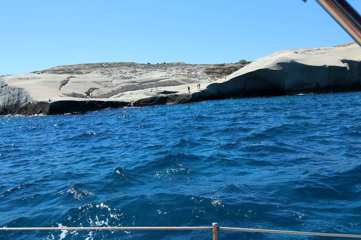
Milos is a volcanic island at the southwestern edge of the Cyclades. Volcanic activity there began 2 to 3 million years ago during the Pliocene, and the last eruption came 90,000 years ago during the Pleistocene. The volcano is considered dormant and able to erupt again. Its main crater forms the natural harbour, which cuts in from the northwest. A Milos boat tour that starts at Adamas crosses this flooded crater, where the depth falls from 130 to 55 metres.
The volcano still gives off heat. In one of the caves on the south coast the heat from below remains strong, and hot sulphurous springs rise on the eastern shore of the harbour. Tuff, trachyte and obsidian are among the ordinary rocks of Milos. Obsidian is a glass-like volcanic rock that breaks with a shell-like fracture. A Milos boat tour along the cliffs passes layers of these rocks.
Bentonite is a swelling clay made largely of montmorillonite. It forms when volcanic ash weathers in seawater, or when hot water circulates through ash beds and turns the volcanic glass into clay. Fresh bentonite beds are white or pale blue or green. As the exposed clay weathers further, it turns cream and then yellow, red or brown from traces of oxidised iron. Milos holds a bentonite deposit, which helps explain the shades seen from a Milos boat tour.
Mining on Milos goes back to ancient times. Pliny the Elder recorded Milos as the richest source of sulphur in the ancient world. Baryte, sulphur, millstones and gypsum were mined in the past. Today bentonite, perlite, pozzolana and small amounts of kaolin are taken from strip or open-pit mines and sold all over the world. The Milos Mining Museum stands in Adamas, the port from which a Milos boat tour sets out.
- Tuff and trachyte: Volcanic rocks among the ordinary stone of Milos, seen in the cliffs on a Milos boat tour.
- Obsidian: A glass-like volcanic rock that Milos supplied to the Aegean and the Mediterranean in the Neolithic.
- Bentonite: A swelling clay that can take in water and grow up to eight times in volume.
- Sulphur: A mineral once mined on Milos, the richest source of it in the ancient world according to Pliny the Elder.
The colours along the shore come from the volcano and the minerals it left behind. A hot cave and sulphur springs show that the ground is still warm. A Milos boat tour passes the shore of an island that gave ancient artists the pigment known as Melian earth and, by the account of Pliny the Elder, held the richest sulphur supply in the ancient world.
What is the history behind a Milos boat tour?
A Milos boat tour follows a coast with a long past: obsidian valued as a commodity as early as 15,000 years ago, the Bronze Age town of Phylakopi, the Athenian siege of 416 BC and the finding of the Venus de Milo in 1820.
Obsidian, a volcanic glass, made Milos known long before farming began. Traders moved it over long distances and shaped it into sharp stone tools. Those in search of it came by boat, landed in a suitable cove and cut pieces from the quarries without settling on the island. Its obsidian and its position between mainland Greece and Crete made Milos a centre of early Aegean civilisation. A Milos boat tour that stops in a cove echoes the landings of those first visitors.
Phylakopi, on the northern coast, grew in the Bronze Age as obsidian extraction declined, and its first settlers were tuna fishermen. It stayed in use from the middle of the 3rd millennium BC until the 12th century BC. The British School at Athens first dug there between 1896 and 1899. Finds include a Mycenaean-style megaron and the Pillar Room, source of a flying fish fresco now shown in the National Museum in Athens. A Milos boat tour on the north coast passes this site.
In the Peloponnesian War between Athens and Sparta, the Melians were Dorians like the Spartans but stayed neutral. In the summer of 416 BC an army of at least 3,400 men came on 38 ships under Cleomedes and Tisias. The city fell that winter. The men were executed, the women and children enslaved, and 500 Athenian colonists settled. The Melian city stood on the eastern shore of the bay that a Milos boat tour crosses.
On 8 April 1820 a Greek farmer found the Venus de Milo on Milos, then part of the Ottoman Empire. The marble statue stands over 2 metres tall and has lost both arms; a hand holding an apple lay beside it. It has been shown at the Louvre in Paris since 1821. The ancient town where it was found stood on the slope between Trypiti and the landing place at Klima, above the shore seen on a Milos boat tour.
- Obsidian trade: Milos supplied volcanic glass for sharp tools as early as 15,000 years ago.
- Phylakopi: A Bronze Age town on the north coast passed by a Milos boat tour, with a shrine that held the Lady of Phylakopi.
- Siege of Melos: Athens took the city in the winter of 416 BC, and Thucydides dramatised the talks before it in the Melian Dialogue.
- Venus de Milo: A Hellenistic statue of Parian marble found on the island in 1820 and shown at the Louvre since 1821.
The coast seen on a Milos boat tour holds a recorded past, from the obsidian quarries to the walls of Phylakopi. After the siege, the Spartan general Lysander expelled the Athenian colonists in 405 BC and returned the survivors to the island. The apple on Melian coins was a play on mêlon, the ancient Greek word for apple. Other sculptures from Milos include the Poseidon of Melos, now in Athens.
What is Sykia cave on a Milos boat tour?
A Milos boat tour that names Sykia cave refers to a cave on Milos, also written Sikia, which the island’s record shows in a view from its interior. The name Sykia means fig tree in Greek, and sea caves form where waves wear into coastal rock.
The word Sykia, also written Sykea, means fig tree in Greek. The same name marks villages in Chalkidiki, Corinthia, Imathia, Laconia, Larissa and Phocis, and a small doline near Voula in Athens. On Crete, a cave near Zakros beach carries the name Sykias, or Pelekita Cave. A Milos boat tour that stops at Sykia cave therefore meets a common Greek place name, here attached to a cave on Milos.
A sea cave, also called a littoral cave, forms mainly through the wave action of the sea, and erosion is the main process. Such caves appear in sedimentary, metamorphic and igneous rock, and those in igneous rock tend to be larger because the host rock is stronger. The Greek islands are noted for the variety of their sea caves. A Milos boat tour follows a coast of volcanic origin, and tuff, one of its ordinary rocks, is an igneous rock.
To form a sea cave, the host rock first needs a weak zone, and in igneous rock this is a fault or a dike. Waves remove rock faster along such zones. As the sea pushes into the cracks, the surf, the rock particles it carries and the air squeezed inside widen them. Suspended sand and stones add an abrasive force, and sea-cave walls tend to be irregular and chunky. Erosion is ongoing wherever waves batter a rocky coast, including the volcanic shore seen on a Milos boat tour.
Sea cave chambers sometimes collapse, and the hollow left behind is called a littoral sinkhole. Small peninsulas and headlands can hold caves that cut right through, since waves attack them from both sides. When such a tunnel collapses, a free-standing sea stack remains along the coast. Blowholes, partly submerged caves that throw out spray as waves retreat, show the force of the air trapped inside. A Milos boat tour passes a coast where the same forces work on volcanic rock.
- Name: Sykia, also written Sykea, is the Greek word for fig tree.
- Milos record: The island’s record names the Cave of Sikia and pictures it from the inside.
- Cave type: In the terms of a Milos boat tour, a littoral cave is a cave shaped mainly by the wave action of the sea.
- Weak zone: In igneous rock, a fault or a dike gives the waves a line of weakness to follow.
- Collapse: A fallen sea cave chamber leaves a hollow known as a littoral sinkhole.
A Milos boat tour that includes Sykia cave links a common Greek place name with the science of sea caves. Records of Milos list the cave as Sikia and show its interior, while the study of sea caves explains how waves, trapped air and sand cut such chambers and how a chamber can collapse to leave a littoral sinkhole.
What is Papafragas on a Milos boat tour?
A Milos boat tour reaches Papafragas near Pollonia, a seaside village in the north-eastern part of Milos. The register of Greek caves lists Papafragka Cave there as an archaeological site, and Pollonia is the second harbour of the island after Adamantas.
Pollonia, also called Apollonia, takes its name from a temple of Apollo that once stood to the east of the settlement. A small boat runs a regular link from the village to Kimolos. The main beach is sandy, and two more beaches lie near the village: Polychroni’s beach and Piso thalassa, meaning “Back sea”. The 2021 census counted 268 inhabitants. A Milos boat tour on the north-east coast passes this stretch of shore.
The list of caves in Greece places Papafragka Cave near Apollonia and marks it as an archaeological site on Milos, in the Cyclades. The same list names other caves of the island group, such as Vromolimni Cave on Kimolos, the Golden Cave on Folegandros and the Blu Caves on Kato Koufonisi. For a Milos boat tour, Papafragas therefore belongs to a wider set of caves recorded across the Cyclades.
The north coast of Milos also holds Phylakopi, one of the leading Bronze Age settlements of the Aegean and the type-site for the study of Aegean Bronze Age periods. Coastal erosion has cut into the site, though its Pillar Rooms Complex remains intact. The Archaeological Museum of Milos in Plaka holds findings from Phylakopi, from the early to the late Bronze Age. A Milos boat tour along the north coast passes this shore of erosion and settlement.
An inlet is a long and narrow indentation of a shoreline, such as a small arm, cove or bay, that leads to a larger body of water. On rocky coasts the sea works along joints and faults, and the cracks grow into sea caves; when a cave breaks through a headland, a natural arch forms. Mediterranean monk seals now use sea caves to rest and give birth, and their caves frequently have underwater entries. A Milos boat tour on a rugged shore passes this kind of coast.
- Pollonia: This seaside village in the north-eastern part of Milos takes its name from a temple of Apollo.
- Papafragka Cave: The list of caves in Greece marks this cave near Apollonia as an archaeological site.
- Phylakopi: Coastal erosion has cut into this Bronze Age settlement on the north coast.
- Kimolos link: Outside the Milos boat tour, a small boat keeps a regular connection between Pollonia and Kimolos.
- Monk seals: Mediterranean monk seals now rest and give birth in sea caves that people cannot easily reach.
A Milos boat tour that includes Papafragas works along the north-east of the island, close to Pollonia and its link to Kimolos. The cave there is recorded as an archaeological site, and the same north coast holds the Bronze Age remains of Phylakopi. Wave action on joints and faults explains how sea caves and arches form along such a shore.
What are the Glaronisia islets on a Milos boat tour?
A Milos boat tour reaches the Glaronisia islets north of Milos, where lava of late Pliocene age has cooled into columns of dacite. Dacite is a volcanic rock high in silica, and its columns form through jointing as the lava cools and contracts.
The record of Milos shows columns of dacite lava at the Glaronisia islet, north of the island, and dates the lava to the late Pliocene. The Pliocene is the epoch of the geologic time scale that runs from 5.33 to 2.58 million years ago. It is the second and latest epoch of the Neogene Period, after the Miocene and before the Pleistocene. A Milos boat tour to Glaronisia therefore shows rock that formed toward the close of that epoch.
Dacite forms through the rapid solidification of lava that is high in silica and low in alkali metal oxides. Its composition sits between andesite and rhyolite, and it consists mainly of plagioclase feldspar and quartz. In hand specimen, hornblende and biotite dacites are grey or pale brown and yellow. The name comes from Dacia, a Roman province between the Danube and the Carpathian Mountains, where the rock was first described. The columns seen on a Milos boat tour to Glaronisia are made of this rock.
Columnar jointing is a structure in which sets of closely spaced, intersecting fractures, called joints, split rock into a regular array of polygonal prisms. It occurs in igneous rocks such as basalt, andesite, rhyolite and tuff, and it forms as the rock cools and contracts. Columns range from 3 metres wide down to widths measured in centimetres and reach as much as 30 metres tall. They have between three and eight sides, and six-sided columns are the commonest. A Milos boat tour to Glaronisia shows this structure in dacite.
A sea stack is a steep column or group of columns of rock in the sea near a coast, formed by wave erosion. Isolated, steep-sided islets of volcanic origin are also loosely called volcanic stacks, and coastal stacks give seabirds nesting sites free of predators. A similar Greek name, Glaronisi, means “seagull island” and belongs to an islet off Dia, north of Crete. A Milos boat tour north of the island reaches islets of this volcanic kind.
- Rock: The Glaronisia columns are of dacite, a volcanic rock between andesite and rhyolite in composition.
- Age: The lava dates to the late Pliocene, an epoch that ended 2.58 million years ago.
- Dacitic magma: Its moderately high silica content makes dacitic magma viscous and prone to explosive eruption.
- Volcanic arc: Each Milos boat tour stays within the South Aegean Volcanic Arc, which counts Milos among its dormant and historically active volcanoes.
A Milos boat tour to the Glaronisia islets shows late Pliocene dacite lava set in columns by cooling and contraction. Milos has other rock islets as well: the Arkoudes, about 20 feet high, look like bears and stand near Plathenia Beach and the entrance to the bay of Milos, where only a boat that tours the island brings them into view.
Which fishing villages does a Milos boat tour pass?
A Milos boat tour passes Klima, a seaside village known for its fishermen’s houses called syrmata, which line a cove that once served as the port of ancient Milos. In the north-east, it also passes Pollonia, the second harbour of the island after Adamantas.
The fishermen’s houses of Klima are called syrmata, a word that means “wires”. Each of these traditional houses has two storeys. The fisherman’s family lives on the upper floor, and the ground floor gives the boat shelter through the winter. Doors and windows carry bright paint. Today, a share of the houses serves as rooms for visitors. A Milos boat tour that runs along this coast passes the line of syrmata at the water’s edge.
The Ephorate of Antiquities of the Cyclades links these houses to a much older shore. The syrmata of Klima set the coastline of a cove that was once the port of the ancient city of Milos. Silt carried down the valley now covers a large part of that port, and part of it has sunk into the sea. The ancient city and its port were not lived in again once they were abandoned. A Milos boat tour that passes Klima moves along the edge of this lost harbour.
The ancient city stood on a commanding site on the eastern side of the narrow entrance to the large bay of Milos. The remains of the city, its port and its cemeteries spread over a wide area. They cover the hills of Pyrgiantes and Profitis Ilias and the valleys of Tramythia and Klima. The valley of Klima joins the fishing village to the old city on the slopes above it. A Milos boat tour that leaves or enters the bay passes this narrow entrance.
Pollonia, also known as Apollonia, is a seaside village in the north-eastern part of Milos. It is the second harbour of the island after Adamantas, and its name comes from a temple of Apollo that stood to the east of the settlement. A small boat links the village with the neighbouring island of Kimolos on a regular basis. A Milos boat tour on the north-east coast passes this second harbour.
- Syrmata: The fishermen’s houses of Klima take their name from the word for “wires” and have brightly painted doors and windows.
- Old port: The cove at Klima was once the port of ancient Milos and now lies beside the route of a Milos boat tour, largely silted up and partly under the sea.
- Pollonia: The second harbour of Milos takes its name from a temple of Apollo that stood east of the village.
- Beaches near Pollonia: Polychroni’s beach and Piso thalassa, a name that translates as “Back sea”, lie near the main sandy beach.
A Milos boat tour that follows the shore from Klima to Pollonia passes two kinds of seaside village. Klima keeps the boathouses of its fishermen on a cove that once served the ancient city. Pollonia works as a small harbour with a regular boat to Kimolos. In 1940 Pollonia joined the then community of Pera Triovasalos, and it now belongs to the community of Triovasalos, with 268 inhabitants in the 2021 census.
What does the Kastro above Plaka show on a Milos boat tour?
A Milos boat tour shows the Kastro on the high ground above the harbour, the first of the later settlements near ancient Milos, from the middle of the 13th or early 14th century. Plaka and Trypiti followed in the second half of the 18th century.
The Ephorate of Antiquities of the Cyclades names the Kastro as the first of the later settlements founded in the area of ancient Milos. It dates the Kastro to the middle of the 13th century or the early 14th century. Plaka and Trypiti came much later, in the second half of the 18th century. All of these settlements stayed outside the walls of the ancient city. A Milos boat tour that enters the bay passes below this group of villages on the high ground.
The date of the Kastro falls in the period when Milos belonged to the Duchy of Naxos. After the Fourth Crusade of 1204, the Venetian Marco Sanudo seized Milos and a number of other islands in the Cyclades. He took the title Duke of Naxos, after the island where he set up his capital. Sanudo ruled for twenty years, from 1207 to 1227, and held Milos in his personal possession, along with Paros, Sifnos and Kimolos. A Milos boat tour today sails waters that once belonged to this maritime state.
Sanudo did not make his duchy a vassal of Venice and declared loyalty to the Latin Emperor instead. His dynasty lasted nine generations, and the Crispo family followed it. Both families were Catholic, while the majority of the population was Greek Orthodox. The first Catholic bishop of Milos was appointed in 1253. Under the Crispo dukes, piracy became dominant, and in 1566 the Venetians handed the duchy over to the Ottoman Empire. These changes of rule shaped the villages on the high ground seen from a Milos boat tour.
The new settlements took shape from the old city in a direct way. For the later inhabitants, the ruins were an easy and endless source of building material. Houses and churches rose from well-cut stones, and marble of every kind went into the production of lime. Underground tomb chambers became barns, stables, cellars, storerooms or cisterns. A Milos boat tour that looks up at the Kastro and Plaka therefore sees villages built in part from ancient stone.
- Kastro: The first of the later settlements in the area of ancient Milos, on the hill seen from a Milos boat tour, dates to the middle of the 13th or early 14th century.
- Plaka: The chief town was founded in the second half of the 18th century, outside the walls of the ancient city.
- Zefyria: This inland village served as the chief town of Milos before the title moved to Plaka.
- Museum: The Archaeological Museum of Milos occupies a neoclassical building from 1870 on the main square of Plaka.
A Milos boat tour that looks toward the Kastro sees the result of a long record of rule and change. In the early 18th century the island had over 6,000 people, almost entirely Greek and Christian. By 1798 the population had fallen below 500, and visitors reported that up to two thirds of the buildings lay in ruin. Plaka grew in that same century, outside the old walls.
What is the ancient theatre on a Milos boat tour?
A Milos boat tour passes below the Ancient Theatre of Milos, which stands on a hillside between Trypiti and Klima, where the ancient city stood. The Ministry of Culture describes it as a Roman-era work of the 1st to 4th centuries AD, overlooking the gulf of Milos.
The Ministry of Culture places the theatre on the slope of a hill where the ancient city of Milos once stood, between the settlements of Trypiti and Klima. The site overlooks the gulf of Milos. Trypiti, a small town with 766 residents in 2021, is known for its place next to the catacombs and the Roman theatre. A Milos boat tour inside the bay sails below this hillside.
The theatre is a luxurious work of the Roman era, from the 1st to the 4th century AD. The Ministry of Culture also suggests that building began in the Hellenistic period, while the remains visible today belong to the Roman phase. The design follows the Roman and Romanised theatres of the eastern provinces of the Roman Empire, which took Greek theatres as their model. It is the Roman monument that a Milos boat tour passes on the slope above the bay.
Excavations so far have uncovered the orchestra, a part of the cavea, the stage structure and the western retaining wall. The cavea keeps seven marble rows of seats, and the floor of the stage building survives along with elaborate architectural pieces. Restoration works ended in July 2016, and the theatre now holds around 700 spectators. From the water, a Milos boat tour passes below these marble seats on the slope.
The clearing of the monument started on the initiative of a king of Bavaria, at the time when Otto was king of Greece, and French specialists drew the ruins in 1838. Near the theatre, the British School at Athens excavated a building with a fine mosaic in 1896, among remains of town walls and other buildings. A Milos boat tour passes the shore below this excavated ground.
- Period: The visible remains belong to the Roman phase, from the 1st to the 4th century AD.
- Capacity: Since restoration works ended in July 2016, the theatre holds around 700 spectators.
- Setting: The theatre sits on a hillside above the gulf of Milos, the bay that a Milos boat tour crosses.
- Finds: Works found on this site include the Asclepius now in London and the archaic Apollo now in Athens.
The theatre belonged to a city with a long life. The Ephorate of Antiquities of the Cyclades dates continuous habitation there from at least the 9th or 8th century BC to the 6th or 7th century AD. Parts of its strong walls, which enclosed two hills, are still visible, and in places they stand to a great height. A Milos boat tour that passes the theatre therefore passes the setting of more than a thousand years of city life.
What does the Archaeological Museum show on a Milos boat tour?
A Milos boat tour ties in with the Archaeological Museum of Milos in Plaka, which holds finds from the late Neolithic to the Byzantine period. Its rooms show Bronze Age objects from Phylakopi, obsidian tools, ancient sculpture, inscriptions and a modern copy of the Venus de Milo.
The Archaeological Museum of Milos stands on the main square of Plaka. It fills a neo-classical building from 1870, the work of E. Ziller. Architects of the 21st Ephorate of Prehistoric and Classical Antiquities restored the building, and it has worked as a museum since 1985. In the porch and on the courtyard, a lapidary shows torsos from late antiquity. For a Milos boat tour visitor, the museum adds the land side of the island’s past.
The first room opens with large pottery vessels from the late Bronze Age to the Greek archaic period. A modern copy of the Venus de Milo stands beside them. An inscription found with the original gave the sculptor’s home town as Antioch on the Maeander. The room also holds obsidian tools from the Neolithic to the early Bronze Age. X-ray fluorescence tests trace obsidian found in Greece to Milos, Nisyros or Gyali, and a Milos boat tour circles the first of these sources.
The second room holds the main treasures of the museum: the Bronze Age on Milos. Its cases show Early Cycladic, Minoan and Mycenaean artefacts from Phylakopi and from other places on the island. Phylakopi passed through three phases, from 2300 BC to 1100 BC. Potters of the second phase painted stylised plant and animal motifs in black and red matt paint, and Melian bird jugs went as far as Knossos. A Milos boat tour follows the same island coast where this Bronze Age town stood.
The third room holds ancient Greek pottery. The fourth shows ancient Greek and Roman sculptures, with ancient Greek inscriptions in the local version of the alphabet. In the vestibule, the Ephorate of Antiquities of Cyclades held a temporary exhibition, “taphoi kterizein”, with new finds from ancient cemeteries of Melos. The finds came from rescue excavations made before new tourist accommodation went up or the mines grew. The grave offerings dated from Mycenaean, Archaic and Roman times, a record that a Milos boat tour cannot show from the sea.
- Building: A neo-classical building of 1870 on the main square of Plaka has housed the museum since 1985.
- Room 1: Large pottery vessels, obsidian tools and a modern copy of the Venus de Milo fill the first room.
- Room 2: Early Cycladic, Minoan and Mycenaean artefacts from Phylakopi form the core of the collection.
- Land and sea: A Milos boat tour and a visit to the museum cover the sea and land sides of Milos.
A Milos boat tour shows the coast of the island, and the museum in Plaka shows what people left on that coast over thousands of years. The collections run from Neolithic obsidian tools to Byzantine objects. The best pieces from Phylakopi now sit in the Ashmolean Museum in Oxford, the British Museum and the National Museum of Athens, so the rooms in Plaka keep the finds that stayed on Milos.
Which south coast beaches does a Milos boat tour reach?
A Milos boat tour on the south coast reaches Firiplaka, a popular beach with Provatas to its west, and Palaeochori Bay, where geothermally heated vents open in the shallow sea. Two new species of heat-loving archaea were first described from those vents.
Firiplaka ranks as a popular beach on Milos. Umbrellas, sunbeds and a bar hut stand on the sand, and the largest part of the road to the beach is asphalt. A Canadian commercial for Greek Oikos yogurt, with a mermaid in the scene, was shot at Fyriplaka Beach, an alternative spelling of the name. A Milos boat tour reaches the same sand from the water, with Provatas next along the shore to the west.
Palaeochori Bay is a second name on a Milos boat tour of this side of the island. Off the bay, geothermally heated vents release hot water into the sea. In a study published in 2000, researchers described two new archaea isolated from these vents: Thermococcus aegaeicus and Staphylothermus hellenicus. Both are hyperthermophiles, single-celled members of the domain Archaea that thrive in very hot water and depend on sulfur for growth.
Staphylothermus hellenicus was isolated in shallow vents off the coast of Greece in 1996. It grows best at 85 °C, at pH 6 and in water with 3–4% salt. The cells measure 0.8–1.3 μm across and gather in clumps of up to 50. The microbe lives without oxygen. A third microbe, Deferrisoma palaeochoriense, carries the name of the bay that a Milos boat tour visits; it is a heat-loving bacterium isolated from a hydrothermal vent there.
The heat behind these vents runs deep. High temperature geothermal energy, above 90 °C, lies 1–2 kilometres beneath Milos. The Milos Island Project relied entirely on geothermal energy to turn salt water into drinking water, with a mix of direct and indirect desalination. It counts as a success, since it produced drinkable water at a low cost without polluting the environment. A Milos boat tour crosses the sea above this hot ground.
- Firiplaka: A popular beach with umbrellas, sunbeds and a bar hut, reached on land by a largely asphalt road.
- Palaeochori Bay: The vents off this bay on a Milos boat tour gave science two new species of archaea.
- Staphylothermus hellenicus: This microbe from the vents grows best at 85 °C and lives without oxygen.
- Drinking water: The Milos Island Project made drinking water from salt water with geothermal energy alone.
The south coast on a Milos boat tour has two sides. Above the water, Firiplaka offers sand, sunbeds and a link to a television commercial. Below the water, the vents off Palaeochori Bay release volcanic heat that supports microbes able to live near 85 °C. Richly coloured sediments mark the floor of the Aegean around Milos and Santorini, and a Milos boat tour passes over that altered volcanic ground.
Which animals live on and around Milos on a Milos boat tour?
A Milos boat tour passes the home of the Milos viper, an endangered venomous snake endemic to the Cyclades, and of the Milos wall lizard. Skinks, passerine birds and introduced house mice and black rats share the island, while microbes live on carbonate crusts near vents offshore.
The Milos viper, also called the Cyclades blunt-nosed viper, is a venomous snake of the family Viperidae. It is a subspecies endemic to the Cyclades, and its range covers Milos, Siphnos, Kimolos and Poliaigos. Its name, schweizeri, honours the Swiss herpetologist Hans Schweizer, who lived from 1891 to 1975. Adults reach an average total length of 50–70 cm, tail included, and the largest on record measured 98.5 cm. A Milos boat tour that passes Kimolos and Poliaigos stays inside its range.
On the island that a Milos boat tour circles, gut studies of road-killed snakes show what the viper eats. Adults feed on passerine birds. Young vipers under 35 cm feed mainly on Milos wall lizards and European copper skinks. The western Cyclades have no native rodents, and the house mice and black rats there were introduced. Researchers link the diet of birds and lizards to this lack of native rodents. The snake lives largely on the ground, yet on autumn nights it climbs trees to hunt.
The IUCN lists the Milos viper as endangered, with less than 4,000 adults in the wild as of 2022 and a continuing decline. Feral cats, persecution and collectors take their toll, and the habitat shrinks in extent and quality. In 1998, 500–600 adults a year were removed from the wild or killed. The Berne Convention lists the snake as strictly protected. Local medical centres report bites on average once a year on Kimolos and four times a year on Milos, with no recorded deaths.
The Milos wall lizard, Podarcis milensis, is a small Mediterranean lizard listed as vulnerable and endemic in Greece. Its body measures no more than 6.5 cm, and the tail is twice as long. Males have a brown back, with black flanks, throat and head sides spotted white, yellow, blue or light green. Females carry white stripes along the edges of the back. On Milos, the island of a Milos boat tour, it replaces Erhard’s wall lizard, and it also lives on Kimolos, Falkonera, Antimilos and Parapola.
- Milos viper: An endangered snake endemic to the Cyclades, with less than 4,000 adults in the wild as of 2022.
- Milos wall lizard: A small lizard that prefers cultivated land and basks on banks and piles of stones.
- European copper skink: A small reptile on the island of a Milos boat tour, hunted by young vipers.
- Introduced rodents: House mice and black rats were brought to the western Cyclades, which have no native rodents.
- Dwarf elephants: Historical publications briefly reported remains of dwarf elephants from Milos, without detailed information.
The sea around a Milos boat tour holds life on a smaller scale: microorganisms live on carbonate crusts close to hydrothermal vents off the coast of Milos. On land, the Milos wall lizard is becoming rare due to habitat loss, and the viper faces cats, collectors and road traffic. Falkonera, an uninhabited island between Milos and the Peloponnese, also supports a population of the lizard and forms part of the Natura 2000 network.
Which islands does a Milos boat tour reach?
A Milos boat tour reaches Kimolos, Polyaigos and the smaller islets around Milos. Polyaigos lies 6.2 km east of Milos and is the largest uninhabited island of the Aegean. Kimolos sits across a channel 1 km wide, and Antimilos stands alone 21 km to the northwest.
A Milos boat tour that heads east from Milos reaches Polyaigos after a short crossing. The island belongs to the Cyclades and lies between Milos and Kimolos: Kimolos is 2 km to its north west, and Milos is 6.2 km to its west. Polyaigos measures 6 km along its longest axis and 4.3 km across at its narrowest. The land covers about 18 square kilometres, and the coastline runs for 22 to 27 km. Administratively, the island is part of the community of Kimolos.
The name Polyaigos refers to goats, and goats are its only inhabitants. Their grazing keeps the island barren, with no village and no farms on its slopes. Ptolemy, Pliny the Elder and Pomponius Mela all recorded it in ancient times. The Greek Orthodox church owns a large part of the land and sublets plots to herdsmen from Milos and Kimolos. Two hills shape the skyline seen from a Milos boat tour: Stroggylo, which rises to 330 metres, and Psilo Vouno, which reaches 370 metres.
The beaches of Polyaigos lie mainly on its southern side. Sea caves open at the waterline along the coast, and these caves shelter a shrinking population of Mediterranean monk seals (Monachus monachus). Kimolos, the neighbour to the west, is twice the size of Polyaigos. It lies northeast of Milos across a channel 1 km wide and covers 36 square kilometres. Its main village, Chorio, sits on a hill in the south-east, and Psathi is the port. The 2021 census counted 810 residents on the island.
Kimolos carries a long record of names. Ancient sources also call it Echinousa, possibly after the viper, a snake still common there. In the Middle Ages it became Argentiera, after the silver-coloured rocks of its southern coast. Those rocks supplied “Kimolia Gi”, or Kimolian earth, a trade good that made the island a major trade hub. Kimolos, Milos and the islets around them all belong to the Aegean volcanic arc, so a Milos boat tour stays inside one volcanic group from start to finish.
- Antimilos: This uninhabited mass of trachyte rises to 671 metres, 21 km northwest of Milos, and its old crater is still clear.
- Erimomilos: The second name of Antimilos means “Desert Milos”, and a rare goat, Capra aegagrus pictus, lives on the island.
- Akradies: These uninhabited offshore islands belong to the municipality of Milos, together with Antimilos.
- Agios Efstathios and Agios Georgios: These two uninhabited islands fall under the municipality of Kimolos, together with Polyaigos.
- Ancient dispute: Melos and Kimolos once both claimed Polyaigos, and the Argives ruled that the island belonged to Kimolos.
A Milos boat tour that keeps to the eastern channel passes Kimolos and Polyaigos close together, while Antimilos stands apart in open water to the northwest. That island once carried the names Ephyra and Ephora, the second meaning “watchtower”, because the sea was visible over long distances from its summit. Ancient inhabitants turned its crater into an open rain tank, and obsidian arrowheads and old walls point to prehistoric settlement there.
When is the best season for a Milos boat tour?
The Milos boat tour season matches the dry summer of the Cyclades. Milos has a Mediterranean climate with mild, rainy winters and warm to hot dry summers. The meltemi, a strong north wind, blows from late spring to mid-September and shapes conditions at sea.
Milos has a Mediterranean climate, class Csa in the Köppen system. Winters are mild and rainy, while summers run warm to hot and stay dry. The Cyclades as a whole share a dry and mild climate, and even the higher ground, where temperatures drop, does not see wintry weather as a rule. Milos is a popular tourist destination during the summer, so the Milos boat tour calendar centres on the dry months, when rain plays little part in the forecast.
The main summer factor for a Milos boat tour is the meltemi. The word is the Greek name for the etesians, the strong, dry north winds of the Aegean Sea. They blow periodically from late spring to mid-September and form a dominant weather influence across the Aegean basin. In the central Aegean they come from the north, and in the southern Aegean and the Cretan Sea they turn into northwesterlies. Milos lies just north of the Sea of Crete, at the southwestern edge of the Cyclades.
The meltemi reaches its peak strength in the afternoon and tends to die down at night, though at times it lasts for days without a break. It rises in clear weather without warning and can blow at force 7–8 on the Beaufort scale. At that strength, the bulk of inter-island ferries cannot sail. Leisure sailors, on the other hand, value its steady breeze. A Milos boat tour plan for the windy months weighs the forecast wind as much as the sun and the sea temperature.
The meltemi also explains the clear skies of a Cycladic summer. Weather under the etesians is ordinarily fine and clear, and the northerly air tempers the fierce summer heat of the region. The name etesian comes from the Greek etos, “year”, for the yearly return of these winds, and the modern name is thought to come from the Italian mal tempo, “bad weather”. Outside the window from late spring to mid-September, the wind pattern no longer sets the rhythm of a Milos boat tour.
- Climate type: Milos has a Mediterranean Csa climate with mild, rainy winters and warm to hot dry summers.
- Wind window: The meltemi blows from late spring to mid-September across the Aegean Sea.
- Wind direction: In the southern Aegean the meltemi blows from the northwest.
- Wind strength: The meltemi can reach force 7–8 on the Beaufort scale in clear weather.
- Ferry season: The catamaran ferry on the Western Cyclades line to Kimolos runs only during the tourist season.
A Milos boat tour fits the dry summer of Milos, when the island draws its visitors and the Western Cyclades links run at full strength. The meltemi is the one variable that changes from day to day, and its afternoon peak carries the greatest weight. Wind direction, wind strength and the daily forecast all shape the route a Milos boat tour follows around the island and toward Kimolos.
What do travelers ask about a Milos boat tour?
A Milos boat tour raises questions about travel to the island, the main town, the sites on land and links with other Cyclades trips. The answers below cover the airport, Plaka, the catacombs and the volcanic tie between Milos and Santorini in the Cyclades.
How does a traveler reach Milos before a Milos boat tour?
Milos Island National Airport (IATA: MLO) lies 5 km southeast of the harbour and opened on January 17, 1973. Its short runway takes only Dash 8, ATR 42 or smaller aircraft, and taxis and buses link it to the rest of the island. By sea, Kimolos sits on the Western Cyclades ferry line to Piraeus, and a local ferry boat crosses between Kimolos and Milos.
Which village is the main town for a Milos boat tour visitor?
Plaka is the chief town of Milos, and its official name is Milos. It sits on top of a large rock above the gulf of Milos, with Kastro on a hill above it. The lanes between walls and buildings are too narrow for cars, so motorbikes and mopeds are the only usable vehicles. The 2021 census counted 902 residents.
What are the catacombs a Milos boat tour visitor can see on land?
The Catacombs of Milos are an ancient underground Christian cemetery from the 1st to the 5th century AD. They lie near Trypiti, next to the agora of ancient Melos and 200 metres east of the ancient theatre. Trypiti means “made with holes”, after caves cut into the porous volcanic rock. The galleries range from 1 to 5 metres wide and 1.6 to 2.5 metres high.
Can a Milos boat tour pair with a Santorini catamaran cruise on another trip?
Milos and Santorini are the two volcanic islands of the Cyclades; the other islands of the group are peaks of a submerged mountain range. Both sit on the Hellenic arc of volcanic centres. Milos receives fewer visitors than Santorini and Mykonos, so a Milos boat tour and a Santorini catamaran cruise show the same volcanic chain in two settings.
Featured photo: dronepicr, CC BY 2.0, via Wikimedia Commons.