A Zakynthos boat trip takes passengers around the coast of Zakynthos by caique, speedboat or glass-bottom boat. Trips reach cliffs, coves, islets and clear swimming spots. It is one of the sea excursions in Greece on Greece VIP.
This post covers what a Zakynthos boat trip includes, the harbours and the boat types. It also covers Navagio, Marathonisi and the Vasilikos peninsula. The Xigia springs, the west coast coves and the islets follow, then sea life, safety and what to bring. Kefalonia, the best season and common questions come last.
Each section ends with a Zakynthos boat trip or a nearby sea tour that can be booked online.
What does a Zakynthos boat trip include?
A Zakynthos boat trip is a sightseeing trip by water. It starts and ends at the same place. The route passes sea caves, small islets and quiet beaches. Each stop shows a piece of the island’s nature and history.
Passengers board by the gangway, a narrow walkway onto the ship. On old sailing ships, the word meant the narrow passage from the quarterdeck to the forecastle. These were the back and front decks.
In the north, a Zakynthos boat trip reaches the Blue Caves. They lie northeast of the Agios Nikolaos settlement, near Cape Skinari. Drakospilia, the “Dragon Cave”, sits very close to the same cape.
The islet off Agios Nikolaos is also called Megalo Nisi, meaning Big Island, or Skinari. It holds ruins of a church and a monastery. On its highest point stand the remains of a Venetian vardiola, a lookout post.
A Zakynthos boat trip in the north also passes over history. The British submarine HMS Perseus struck an Italian mine on 6 December 1941. This happened 7 miles north of Zakynthos. Only one of the 61 people on board survived.
In the south, a Zakynthos boat trip can reach the islet of Pelouzo. It lies 2 nautical miles south of Daphni beach. It belongs to the National Marine Park of Zakynthos. Its single beach has very white, fine sand.
- Cape Skinari: The cape lies 39 kilometres, or 21 nautical miles, from Cape Kyllini on the Peloponnese.
- Perseus wreck: The wreck lies 52 metres down, found in 1997 by a team led by Kostas Thoctarides.
- Monk seal: A large monk seal was seen at Korakonisi on 24 April 2023.
John Capes, the lone survivor of HMS Perseus, swam five miles to Kefalonia. Islanders hid him for 18 months. He was then smuggled to Izmir in a caique, a wooden boat.


Which harbours does a Zakynthos boat trip leave from?
A Zakynthos boat trip leaves from harbours and small beaches all around the island. Zakynthos town serves the east coast. Agios Nikolaos and Alikanas serve the north coast. Porto Vromi serves the west, and Laganas serves the south.
A Zakynthos boat trip from the town starts at its harbour. Zakynthos town is the second-largest town of the Ionian Islands. Above the harbour rises Bochali, a hill district. During Venetian rule, the island’s upper class lived there.
Agios Nikolaos sits at the head of a small bay. The islet of Agios Nikolaos closes off this bay. The village stands at an average height of 20 metres. It became an official settlement in 1991.
Porto Vromi is a small beach of white pebbles and very clear water. It lies west of the village of Maries. Maries stands at 390 metres on the western slopes of Mount Vrachionas.
On the northeastern coast, a Zakynthos boat trip can start at Alikanas. The village has a wide sandy beach. It lies 1 km from the village of Alykes. The beach is home to the sea lily, a plant protected by Greek and international law.
Laganas lies at the head of Laganas Bay, about 17 km south-southwest of Zakynthos town. It sits at an average height of 8 metres. The village is the starting point for turtle boat tours in Laganas Bay.
- Microbe “ruins”: Underwater shapes off Alikanas Bay were made by microbes millions of years ago.
- Vesalius memorial: A memorial on Laganas beach honours Andreas Vesalius, a Belgian Renaissance teacher of anatomy.
- Maries: The village lies about 7 km south of Volimes and 27 km west-northwest of Zakynthos town.
The starting harbour shapes a Zakynthos boat trip. Agios Nikolaos lies close to Cape Skinari and the caves. Porto Vromi opens to the west coast. Laganas faces its own bay in the south. Each one starts a different route.
Which boat types run a Zakynthos boat trip?
A Zakynthos boat trip can use a glass-bottom boat, a wooden caique or a small motorboat. Hire boats and pedalos also work in calm water. Each boat type moves, steers and shows the sea in its own way.

Hullam Jones and Philip Morrell invented the glass-bottom boat in Marion County, Florida. They wanted tourists to see the clear waters of Silver Springs. In 1924, new owners developed a gasoline-powered version.
A glass-bottom boat has a clear floor. Builders design it so the largest number of tourists can look down through the glass. Typical views are underwater plants and animals, reefs and shipwrecks.
A Zakynthos boat trip can also run on a caique, a wooden boat. Builders paint its wooden frame with orange primer, a first coat of paint. The primer preserves and seals the timber.
An outboard motor drives small boats and steers by pivoting on its mounting. With the engine off, its skeg, a fin below it, acts as a rudder. The motor tilts up to protect the propeller in shallow water.
A ship replica is a rebuilt copy of a ship that no longer exists. Certain replicas are fully seaworthy. Others are modern boats built only to look like a historic vessel.
- Pedalo: Its pedals turn a paddle wheel, so it suits calm water at beaches.
- Hire boats: Motorboats, sailboats, rowboats and inflatable boats are hired by the hour, day or week.
- Outboard history: Ole Evinrude, a Norwegian-American inventor, built the leading early outboard motor in 1909.
Pirate-style boats borrow old symbols. Pirate captains flew the skull and crossbones on a black flag in the 1710s. The name Jolly Roger goes back at least to a 1724 book by Charles Johnson.
What does a Zakynthos boat trip show of Navagio from the sea?
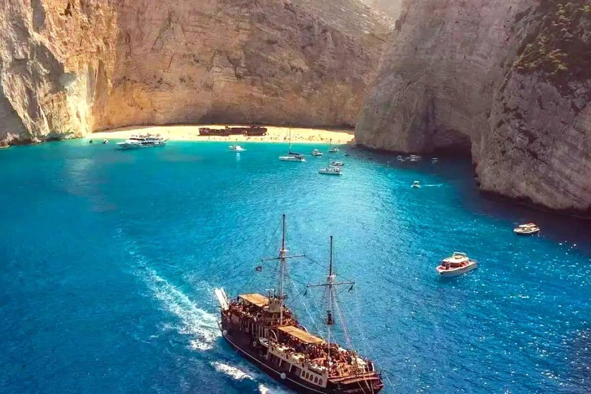
A Zakynthos boat trip shows Navagio from below its cliffs. These walls rise straight up to 200 m. The old ship lies in the middle of the beach. From the water, visitors see the rock, the wreck and the cove together.
Navagio sits on a 10 km stretch of steep cliffs. This coast lies on the northwest side of the island. Sea erosion, or wearing by waves, shaped it. Movement of the earth’s crust shaped it too.
On a Zakynthos boat trip, the pale rock stands out. Maps show it is mainly limestone from the Late Cretaceous, a very old age. Water has dissolved hollows and cracks all through this stone.
Faults, or breaks in the rock, cut the slopes around the beach. Weathering and dissolution carve the vertical faces and overhangs. Earthquakes trigger landslides and rockfalls that keep reshaping this coast.
Falling rock is a real danger. Serious injuries from it happen frequently at Navagio. Geologists track rockfall with repeated drone and laser scanner surveys. A Zakynthos boat trip views these cliffs from the water.
The cliffs hold rare plants. Asperula naufraga is a critically endangered plant. One of its five known groups grows here, 190 to 230 m above the sea. Micromeria browiczii, found only on Zakynthos, grows at one of its 15 known sites here.
- Discovery: A patrol boat of the Greek financial police found the stranded ship with smuggled cigarettes.
- Cargo: The ship held about two thousand boxes, valued at 30 million drachmas.
- Crew story: The crew said engine trouble left them drifting for three days in bad weather.
Locals first feared harm to nature and tourism from the ship. Today a Zakynthos boat trip joins hundreds of thousands of visitors each season. A court in 2016 rejected claims over the wreck. Private individuals still own the ship.
What does a Zakynthos boat trip see at Marathonisi?
A Zakynthos boat trip to Marathonisi reaches a small islet in Laganas Bay. Its only sandy beach curves around the northern end. Sea turtles nest on this coarse sand. Low dunes rise behind it, and a half-ruined church stands nearby.
The dunes reach up to 50 m inland. Behind them stands a hill with dense Mediterranean plants. Marathonisi is also home to Limonium zakynthium, a plant found only on Zakynthos.
The church of Panagia Marathonisiotissa already stood in the 15th century. It is the only building on the islet and belongs to the church of Lithakia. Its priest holds a service there on 15 August.
On a Zakynthos boat trip, the beach looks quiet. Yet it had the highest nesting success of the six beaches in Laganas Bay. Sekania and Marathonisi hold the densest nesting of the six.
Marathonisi offers the widest band of nesting sand, about 14.5 m. The beach faces north, and its sand differs in colour. Eggs take up to 89 days to hatch. Hatchlings here are mainly male.
Anchoring is banned because the islet lies inside the marine park. So a Zakynthos boat trip cannot drop anchor here. The islet became private property in 1972, but building was banned. A company had wanted a 400-bed hotel.
- Umbrellas: Beach umbrellas are banned on Marathonisi, apart from approved fixed furniture.
- Distance: If hatchlings appear by day, visitors stand to the side at 3-4 metres, never in front.
- Water: Visitors never pour water on hatchlings or place them straight into the sea.
Crawling to the sea builds the muscles of young turtles. That is why people let them crawl alone. A Zakynthos boat trip finds old faith, rare plants and turtle life on one islet.
What does a Zakynthos boat trip see on the Vasilikos peninsula?
A Zakynthos boat trip along the Vasilikos peninsula passes a string of beaches. Gerakas lies to the south. Porto Roma and Mavratzis lie to the east. Agios Nikolaos sits to the northeast, with clay cliffs and a small islet nearby.
Vasilikos village sits on Cape Geraki, 58 m above sea level. Banana, Porto Zoro and Kaminia are also nearby beaches. The nearest lies 1000 metres away. The farthest is about six and a half kilometres away.
Banana and Ionio beaches lie north of Ano Vasilikos, facing the Peloponnese. The village stands below Daphni hill, 270 m high. Stone tools from the Middle Palaeolithic, the Old Stone Age, were found around Agios Nikolaos.
Gerakas stands out from a Zakynthos boat trip. The beach is 15-30 m wide, with fine, soft sand. Clay cliffs 15-20 m high hide the lights of buildings inland.
By land, a single trail leads down to Gerakas. The sandy seabed makes the approach from the sea smooth. Turtle nests can fail when the underground water rises and floods them.
Daphni beach mixes pebbles and stones with soft sand. Underwater rocks leave only small openings for a Zakynthos boat trip. Daphni has the narrowest and steepest nesting beach of the six.
- Research: The marine park has run a research station at Gerakas since 2014.
- Pelouzo: This islet, also called Kalonisi, keeps ruins of a Venetian-era monastery tower.
- Monastery: The monk Angelos Salviatis built a monastery to the Virgin there in 1705.
The south-east of the Skopos peninsula shows Triassic rock. It holds evaporites, meaning salt-formed rock, plus gypsum and limestone. A Zakynthos boat trip here passes the island’s long past in stone.
What are the Xigia sulphur springs on a Zakynthos boat trip?
A Zakynthos boat trip reaches Xigia, a small beach in the north with deep blue water. It is the only beach on the island with healing spring water. Sulphur from nearby caves flows out at the shore. The sea there turns white.
The springs are coastal springs rich in hydrogen sulphide, a gas made of hydrogen and sulphur. The white colour comes from flakes of colloidal sulphur. These are tiny sulphur bits floating in the water.
Colloidal sulphur is credited with softening the skin and smoothing wrinkles. It is also said to ease skin conditions. The beach itself has golden sand, with caves right next to it.
Mineral springs pick up salts, sulphur compounds and gases as their water travels underground. Hydrogen sulphide forms when microbes break down organic matter without oxygen. Tiny living things called sulphate-reducing microorganisms do this job.
On a Zakynthos boat trip, the smell arrives before the beach comes close. The springs give off a strong smell of sulphur. The water around the springs stays at 18 °C.
Xigia is a popular stop for people with arthritis, a painful swelling of the joints, or skin problems. The beach is used mainly by people with pain in the legs and joints.
- Village: The springs belong to Orthonies, a village 454 m up on the north-western side of Mount Vrachionas.
- Old use: In past times, villagers used the sulphur to heal wounds on their animals.
- Nearby beach: Makrys Gialos sits in a small cove 25 km north-east of Zakynthos town.
A swim at Xigia means cool, milky water and a sharp smell. The white sea meets deep blue water in a strong contrast. Xigia stands out on any Zakynthos boat trip along the north coast.
What does a Zakynthos boat trip see at Porto Vromi and Porto Limnionas?
A Zakynthos boat trip on the west coast passes Porto Vromi and Porto Limnionas. Steep cliffs here form the foot of Mount Vrachionas. Shrubland covers the cliffs, and Aleppo pine fills the forests. Mountain villages stand high above both coves.
From Porto Vromi, tourist boats also head north for boat trips to the Blue Caves. Maries, the village above Porto Vromi, had 296 residents at the 2011 census. About 1 km north-west of Maries, five or six rock-cut tombs form a prehistoric cemetery. It has not yet been excavated.
The village of Anafonitria, near Porto Vromi, stands 340 m up. Until 1915 it carried the name Plemonari. Farther along a Zakynthos boat trip, Agios Leon rises above Porto Limnionas and Porto Roxa. It has 437 residents and lies 23 km from Zakynthos town.
The first settlers of Agios Leon were freed serfs, meaning released farm workers, from Catania in eastern Sicily. The Venetians sent them up the mountain. The village church honours Saint Leo, a bishop of Catania.
Kampi is a semi-mountain village near the west coast, 178 m up. It lies 26 km west of Zakynthos town and had 59 residents at the 2011 census.
- Area: The Natura 2000 site runs from the bay of Agios Nikolaos in the north-east to Cape Marathia.
- Birds: The rock partridge, the black-eared wheatear and the olive-tree warbler live along this coast.
- Plants: The coast holds Limonium phytosianum, a plant found only here, and Serapias ionica.
In total, 214,190 stremmata of this coast fall inside the Special Protection Zone. A stremma is a Greek land unit. On a Zakynthos boat trip, the cliffs show this wild, protected side of the island.
Which islets does a Zakynthos boat trip pass?
A Zakynthos boat trip passes rocky islets around the coast. Agios Nikolaos islet lies south-south-east of Cape Skinari. Pelouzo sits in Laganas Bay. The Strofades hold an old fortress monastery. Each islet has a story of monks, pirates or war.
Mikro Nisi is also called Garezos or Kapari. This rocky islet lies just north of a hamlet with the same name. The hamlet lies 27 km north-west of Zakynthos town. It had 38 residents in 2011.
The houses of the hamlet stand around a small Venetian watchtower at Platys Gialos. The tower stands 25 m from the sea. Agios Andreas, also called Agios Georgios, lies north-west of Volimes. Its name comes from a former monastery of Saint Andrew, with ruins of a wall.
On a Zakynthos boat trip, Pelouzo appears one nautical mile off the coast. Under Venetian rule, it belonged to the Catholic monastery of Saint Francis. German bombs damaged the monastery in the Second World War.
The 1953 earthquake then destroyed the Pelouzo monastery completely. The Strofades are two islands covering about 2.6 square kilometres. Stamfani, the larger one, is fairly flat and fertile. Arpyia, the smaller one, is rocky and cut off by dangerous reefs.
The name Arpyia comes from the Harpies of Greek myth, spirits of stormy winds. Princess Irene Laskarina survived a shipwreck on Stamfani. She was the daughter of the Nicaean emperor Theodore the First. At her request, a fortress monastery rose there, with walls 25 m high.
- Pirates: In 1717 Muslim pirates robbed the monastery. Its treasures later turned up for sale in Asia Minor.
- Icon: Patmos captains bought its icon of the Virgin, “Joy of All”, and sent it back.
- Lighthouse: The lighthouse became automatic in 1985, leaving the last monk as the only person there.
The islands can only be visited by private boat. The small harbour on Stamfani cannot take large ships. These limits keep the Strofades quiet, far from a Zakynthos boat trip.
What sea life besides turtles meets a Zakynthos boat trip?
A Zakynthos boat trip meets far more than turtles. Seabirds, seals, dolphins and jellyfish share these waters. About 119 bird species have been recorded in the National Marine Park of Zakynthos. Each group adds something new to spot.
Zakynthos and the Strofades islets lie on a bird migration route. Birds stop there to rest in spring and autumn. Eleonora’s falcon, a bird of prey, lives in the park. It has not been recorded on any island north of Zakynthos.
The Strofades islets count as an Important Bird Area. About 2,000 to 3,000 pairs of Scopoli’s shearwaters breed there. Hunting is banned on these islets. A large spring migration of turtle doves also passes through.
On a Zakynthos boat trip, a shearwater carries an old story in its name. Its species name, diomedea, recalls the Greek hero Diomedes. After his death, his grieving friends were turned into white seabirds.
The species name of the European shag, aristotelis, honours the philosopher Aristotle. A green sheen on its feathers gives it the name green cormorant. Before a dive, it jumps up out of the water for extra push.
A 2015 survey found monk seals all year in the south of Zakynthos. They mainly pass through and feed there. It recorded six sea caves fit as seal shelters, one fit for births.
- Risso’s dolphin: White scars from other dolphins cover it, and older ones look almost all white.
- Barrel jellyfish: It can reach one metre, yet its sting causes only mild burning.
- Fried egg jellyfish: It swarms near the coast in late summer and is harmless to humans.
Every Zakynthos boat trip is a fresh chance to spot this wildlife. Birds, seals, dolphins and jellyfish share the sea with the turtles. Sharp eyes see far more than turtle shells.
How safe is a Zakynthos boat trip?
A Zakynthos boat trip runs under clear Greek port rules. These rules cover who boards, where passengers sit and how close boats come to swimmers. Good habits in the water and the sun add more safety for everyone.
Before a Zakynthos boat trip, speedboat operators must refuse passengers who cannot swim. They also refuse anyone who is drunk or on drugs. Operators must not let passengers stand up. Passengers also stay off the gunwale, the top edge of the boat’s side.
A Zakynthos boat trip by speedboat stays 100 m from the outer edge of swimming buoys. Without buoys, the boat stays 200 m from the point swimmers reach. With no swimmers, the limit is 5 knots within 200 m of shore.
No motor-powered leisure craft, private or rented, moves or anchors inside swimming buoys. Rental bases mark a launch lane 7 to 20 m wide. Yellow buoys sit 3 m apart along it.
If a speedboat operator causes an accident, the law is strict. The operator must stay at the scene and give every possible help. The operator also reports it to the port authority at once.
The marine park asks watchers to leave a stressed turtle alone and find another. Swimmers also avoid diving into water of unknown depth. Shallow dives are the top cause of spinal cord injuries in sport.
- Weever stings: A sting from this sand-buried fish needs very hot water for at least 15 minutes.
- Sea urchins: Their brittle spines break off in skin, and hot soaks are thought to ease pain.
- Heat cramps: Electrolyte drinks, which replace lost salt and water, help prevent muscle spasms in the heat.
Clear rules and simple habits keep a Zakynthos boat trip calm. Operators follow the law at sea, and passengers watch their own step and health. Together they turn a day on the water into a safe one.
What do passengers bring on a Zakynthos boat trip?
A Zakynthos boat trip goes better with a light, well-packed bag. Passengers bring sun cover, a quick-drying towel and cold drinks. Binoculars help with spotting wildlife. Small care items for lips, ears and masks also earn a place.
On a Zakynthos boat trip, binoculars bring birds closer. In 10×50, the first number shows how much closer things look. The second number is the front lens width. A large exit pupil makes the image easy to find on a pitching deck.
A vacuum flask is two flasks, one inside the other, joined at the neck. A near-vacuum between them slows heat flow. With a cold drink inside, the outside stays almost free of condensation.
A Zakynthos boat trip bag stays light with thin towels. A peshtemal is a traditional 100% cotton towel whose name means back towel. It dries faster than thicker towels. Microfibre towels are light, durable and somewhat water repellent.
Long swims on a Zakynthos boat trip soak the ear canal skin. This weakens its natural barrier and can lead to swimmer’s ear, an inflamed ear canal. Diluted vinegar drops after swimming can help prevent it.
Swimming goggles work only near the surface, because water pressure presses them hard on the face. Deeper water calls for a diving mask, which lets the swimmer breathe out through the nose.
- Bucket hat: It folds small enough for a pocket and gives sun protection.
- Lip balm: Thin lip skin dries fast in wind; balm with sunscreen helps.
- Gel packs: They stay a slow-flowing gel and do not spill easily.
A Zakynthos boat trip needs only a small bag of smart items. Light towels, cold drinks and sun cover keep the day easy. Simple care for ears and lips adds comfort.
Can a Zakynthos boat trip reach Kefalonia?
A Zakynthos boat trip can reach Kefalonia, since a summer ferry can link Poros with Zakynthos. Poros sits in the southeast of Kefalonia. The name Poros means “ford” or “crossing” in Greek. The south coast of Kefalonia holds old ruins and protected nature.
The name Poros comes from the Vohinas river. The only natural crossing point lies where this river meets the sea. A Zakynthos boat trip to this harbour joins two islands of the same chain.
The Kefalonia Transform Fault Zone runs along the outer border of the Southern Ionian Island Chain. Its four main islands are Lefkada, Ithaca, Kefalonia and Zakynthos. Along this strike-slip fault, two plates slide sideways past each other.
Skala lies about 39 km south of Argostoli, in the south of Kefalonia. Its name is the Greek word for stairs. The houses of the old hillside village seemed to rise like a set of stairs.
Three kilometres along the beach road from Skala towards Poros lies a temple of Apollo. It dates from the 6th century BC. Foundation stones and parts of three Doric columns still stand. Doric is a plain, strong style of Greek column.
Katelios bay is a designated marine Natura 2000 site, an official protected area of the sea. A protected sea grass, Posidonia oceanica, covers a large part of the bay. Sea grass is a plant that grows on the sea floor.
- Mounda beach: Its loggerhead turtle nests on the east of Katelios bay have been protected since 1988.
- Roman villa: Remains of a 3rd-century villa with mosaics in three rooms lie near Skala.
- Katelios river: It is the only river on Kefalonia that flows all year round.
Leivatho lies south of Argostoli on the central south coast. It covers 62.6 km² and had 5,765 inhabitants in 2021. A Zakynthos boat trip to Poros brings this quiet south coast within easy reach.
When is the best season for a Zakynthos boat trip?
A Zakynthos boat trip runs best in late spring and early autumn, when days stay warm. The fifth month of the year averages just 2.5 rain days at the Zakynthos station. Its average high is 23.4 °C. Winter brings far more rain, so dry days are rarer then.
The weather figures come from the station at Zakinthos Airport. Its climate table covers 1961 to 1990 and uses NOAA climate normals. Its extreme records run from 1961 to the present.
In the fifth month the average low is 14.4 °C, and the mean is 19.8 °C. Humidity, the water held in the air, falls from 71.7% in April to 67.8% a month later. A Zakynthos boat trip then meets drier air.
April is cooler, with an average high of 18.9 °C and a low of 11.1 °C. It averages 6.1 rain days, and March has 8.2. The record high is 29.8 °C for April and 35.0 °C for the month after.
Heat lasts into autumn, with a record high of 36.8 °C for September and 32.0 °C for October. Summer nights stay mild. The record low is 12.0 °C for July and 13.4 °C for August.
November brings an average high of 19.0 °C and a low of 12.5 °C. It is the dampest month, with average humidity of 76.0%. A Zakynthos boat trip late in the year meets cooler, wetter air.
- January: It averages 12.8 rain days and 150.4 mm of rain.
- February: It averages 11.3 rain days and 112.8 mm of rain.
- March: Rain drops to 89.6 mm on average.
Across the whole year, the station averages a high of 21.8 °C and a low of 13.9 °C. These numbers make late spring a strong choice for a Zakynthos boat trip.
What do travelers ask about a Zakynthos boat trip?
A Zakynthos boat trip raises questions about travel, safety and comfort on board. Zakynthos airport and the port of Kyllini link the island to the wider world. Sea rules control waste from larger boats. Swimmers need to know their limits in the water.
How do travelers fly in before a Zakynthos boat trip?
Zakynthos airport carries the ICAO code LGZA, a short code used in aviation. It stands just 5 metres above sea level. Its single asphalt runway, 16/34, is 2,228 metres long. A new terminal of 22,150 m² was completed in 2008.
Can travelers see Zakynthos boat trip waters from the plane?
On the main approach to Runway 34, planes fly over Laganas Bay. Then they make a 180-degree turn, a full U-turn. The final approach then passes over Kalamaki beach. So passengers see the bay waters before any Zakynthos boat trip begins.
Which mainland port links to a Zakynthos boat trip?
Kyllini is the mainland port with ferry links to Zakynthos and Kefalonia. Its community had 534 residents in 2021. The name comes from Cyllene, a port town of ancient Elis. Homer first mentions it in the Iliad. Kyllini was also the end of the Kavasila–Kyllini railway, now dismantled.
How did toilets work on ships long before a modern Zakynthos boat trip?
By the late 17th century, sailing ships had toilets called “seats of ease”. These were openings in the bow, the front of the ship. Pipes led from them to the sea. Captains and officers used more private toilets at the stern, in the quarter galleries.
What waste rules apply near a Zakynthos boat trip route?
MARPOL Annex IV, the rules on ship sewage, entered into force on 27 September 2003. It covers ships on international trips of 400 gross tonnage or more. It also covers ships certified for over 15 persons. Treated sewage goes out only beyond three nautical miles from land.
How do swimmers stay safe on a Zakynthos boat trip?
Swimmers need to stay within their own abilities. Currents, depth, temperature and waves all matter. They also need to know the state of the sea. Body heat drains fast in water, even at around 20 °C. Children are advised to learn to swim between 1 and 4 years old.