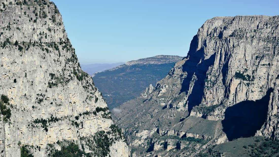
A Vikos gorge hike crosses one of the deepest canyons on Earth, in the Zagori region of Epirus in north-west Greece, from the stone village of Monodendri down to the springs of the Voidomatis river and up to the Papingo villages below Mount Tymfi. This post covers what a Vikos gorge hike includes, where the gorge is, its depth and geology, the route, Monodendri, the viewpoints, the Voidomatis springs, the villages at the end, the plants and animals, the stone bridges, the history of Zagori, Mount Tymfi, how hard the hike is and the best season. It is one of the outdoor tours in Greece on Greece VIP.
Each section ends with a Vikos gorge hike that can be booked online.
What does a Vikos gorge hike include?
A Vikos gorge hike takes walkers into the Vikos Gorge, a limestone canyon in the core zone of the Vikos–Aoös National Park in Epirus. The escorted route descends from Monodendri and leads north through the gorge to the springs of the Voidomatis river.
The Vikos–Aoös National Park lies in the region of Epirus in north-western Greece. It sits 30 kilometres north of the city of Ioannina, in the northern part of the Pindus mountain range. The park was founded in 1973 and is one of ten national parks on the Greek mainland. It covers 12,600 hectares and takes its name from the two major gorges of the area. A Vikos gorge hike therefore runs through land that Greece protects by law.
The core of the park covers 3,400 hectares and holds the Vikos Gorge, which the Voidomatis river carved. The Aoös gorge, Mount Tymphe and a number of traditionally preserved settlements form the peripheral zone. Forestry, grazing, hunting and fishing are banned by law in the core. The gorge lies in that core zone, so the bans apply to the ground that a Vikos gorge hike crosses. Two district forest offices manage the park, and the Papingo office of the World Wide Fund for Nature also plays a part.
Over 100,000 people visit the park each year. They take part in rafting, canoe-kayaking, hiking and mountain biking. The Samaria Gorge tour in Crete offers a comparison on facts. That gorge is 16 km long and its walls rise to almost 300 metres at the narrowest point, while a Vikos gorge hike crosses a canyon with walls of up to 1,350 metres.
- Protection: The park belongs to the Natura 2000 ecological network and is one of the UNESCO Geoparks.
- Elevation: The park spans an elevation range from 550 metres to 2,497 metres at Gamila peak.
- Exits: On a Vikos gorge hike, paths lead out of the gorge from the springs of the Voidomatis to Papingo or Vikos village.
A Vikos gorge hike is a visit to a conservation area as much as a walk. Greece set up the park to conserve the fauna, flora and geological formations of the area. The gorge itself is a site of major scientific interest, because it is in almost virgin condition and is a haven for endangered species.



Where is the gorge on a Vikos gorge hike?
The Vikos gorge hike takes place in Zagori, a region in the regional unit of Ioannina in Epirus, north-western Greece. The gorge cuts the southern slopes of Mount Tymphe, in the northern part of the Pindus mountain range of Greece.
Zagori is a region and a municipality in the Pindus mountains in Epirus, and it is a designated UNESCO World Heritage Site. It covers about 1,000 square kilometres, contains 46 villages and has the shape of an upturned equilateral triangle. Ioannina borders its southern point, and Mount Mitsikeli, 1,810 metres high, forms its south-western side. Only 3.4 inhabitants live on each square kilometre, against 73.8 for Greece as a whole, so a Vikos gorge hike crosses thinly settled country.
Tymphe is a mountain in the regional unit of Ioannina, just south of the 40° parallel. The Aoos river flows to its north, and the Voidomatis, a tributary of the Aoos, has its sources on the mountain. The Vikos Gorge splits the western side of the massif, and a Vikos gorge hike follows that split. The main part of the gorge begins between the villages of Vitsa and Koukouli and ends near the village of Vikos, also called Vitsiko.
The Pindus range is about 160 km long and runs north to south along much of mainland Greece, so it is known as the spine of Greece. It starts near the Greek-Albanian border in southern Albania and enters Epirus and Macedonia. Its highest point is Mount Smolikas at 2,637 metres. The Vikos Gorge and the Aoos Gorge are the two significant gorges of this range.
- Direction: A Vikos gorge hike follows a gorge that runs from north-west to south-east.
- Name: The name Zagori is linked to the Slavic word Zagore, meaning beyond the mountains.
- Villages: Four villages stand inside the park and nine more stand near its borders, with 1,515 people in all.
- Second park: Zagori holds a second national park around Valia Kalda, east of Mount Tymphe.
The location of a Vikos gorge hike can be fixed in steps. Ioannina lies at the southern point of Zagori, which lies on the Pindus range in Epirus. The Vikos Gorge cuts the southern slopes of Tymphe, and the Aoos river, which receives the Voidomatis, bounds the region on the north.
How deep is the canyon on a Vikos gorge hike?
A Vikos gorge hike descends into a canyon with walls from 120 to 1,350 metres deep, whose width falls from 2,500 metres to a handful of metres. The Guinness Book of Records lists it as the deepest canyon in the world in proportion to its width.
The depth of the Vikos Gorge changes along its length, so a Vikos gorge hike meets walls of changing height. Its walls range from 120 to 1,350 metres, and the main part, which stretches from the village of Vikos to Monodendri, reaches about 1,350 metres. The national park article gives a lower figure of about 1,000 metres for the main part. At one point the gorge measures 900 metres deep and 1,100 metres wide from rim to rim.
The length is also given in two ways. The Vikos Gorge article states a length of about 32 km, of which 12 km lie inside the core zone of the park. The national park article describes a gorge 20 km long, with the same 12 km in the core zone. Because depth is set against width, the Guinness Book of Records places the Vikos Gorge first, though gorge lobbyists contest that claim.
The gorge is a deep cross section of the mountain, so its slopes show rock of different ages along a Vikos gorge hike. The upper layers, from 0 to 200 metres down, are relatively young Eocene limestone. From 200 to 700 metres the rock is a stratum from the Campanian era, and below 700 metres it is Jurassic and Cretaceous limestone. Grey Jurassic dolomite dominates the deepest layers. The Vikos Stream and the Voidomatis river carved this cut over millions of years.
Limestone dissolves as water percolates through it, so an underground drainage system has developed. Caves and channels grow wider with time, and when their roofs collapse they leave rocky exposures and vertical slopes. This is also why water is scarce. Water appears on the surface only where the rock is impenetrable. A Vikos gorge hike therefore crosses a karst landscape.
- Slopes: Steep slopes dominate the middle zones and precipitous rocky cliffs dominate the higher zones.
- Stream: The Vikos stream is mostly seasonal and runs all year only in the lowest part of the gorge.
- Glaciation: The final phase of glacial activity is placed in the Last Glacial Maximum, between 22,000 and 20,000 years ago.
A Vikos gorge hike crosses limestone that water has carved over millions of years. The Vikos Stream and its continuation, the Voidomatis river, cut the gorge, and the Voidomatis is a tributary of the Aoös. Published figures for depth and length differ between sources, so each figure here names its source.
Which route does a Vikos gorge hike follow?
A Vikos gorge hike follows a trail that drops from the village of Monodendri into the gorge, runs north to the springs of the Voidomatis River, then climbs out either to Papingo on the north side or to Vikos village on the south side.
The classic Vikos gorge hike begins at Monodendri, a village in Central Zagori. A hiking trail descends from the village into the gorge. The trail then leads north through the canyon to the springs of the Voidomatis River. From the springs, paths lead out of the gorge in two directions. The crossing is one-way, because the start and the finish are different villages, so the walk links two settlements instead of looping back to its first point.
On a Vikos gorge hike, Papingo is the exit on the north side of the gorge. The village lies very near the northern end of the canyon and consists of two settlements, Megalo Papingo and Mikro Papingo, at the base of Mount Radovoli, part of the Tymphe massif. The exit on the south side is Vikos village, also called Vitsiko. The main part of the gorge begins between the villages of Vitsa and Koukouli and ends near Vikos village.
A second Vikos gorge hike runs the other way. From Monodendri, it is possible to walk south through the gorge to the 18th century stone bridges near Kipi. This version heads in the opposite direction from the springs, which lie to the north. The stone bridges belong to the network of arched crossings that linked the villages of Zagori until modern roads opened in the 1950s.
- Direction: The gorge runs from the northwest to the southeast.
- Stream: On a Vikos gorge hike, the stream runs permanently only in the lowest part of the gorge.
- Megas Lakkos: An equally deep secondary gorge crosses the middle of the main part.
At the springs, a Vikos gorge hike splits into two exits. Papingo leads to the north side and Vikos village to the south side. The Voidomatis River forms in the end part of the main gorge from small, mostly seasonal streams, and the river itself is a tributary of the Aoös.
What does a Vikos gorge hike show at Monodendri?
A Vikos gorge hike shows Monodendri, a village of traditional stone-built houses in Central Zagori, together with the historic monastery of Agia Paraskevi, which stands on the edge of the gorge and was founded in 1412 according to an inscription.
Monodendri, the starting village of a Vikos gorge hike, lies in the Ioannina regional unit of Epirus, 41 km north of the city of Ioannina. It stands at a height of 1,060 m and keeps much of its traditional stone-built architecture. The name joins the Greek adjective monos with the noun dendri, and it comes from a large fir tree that stood near the former monastery of Agios Minas, was struck by lightning, and survived until 1840.
A Vikos gorge hike starts in a village that was previously considered a neighbourhood of Vitsa. Like the other Zagori villages, it prospered commercially and economically in the 17th and 18th centuries. Schools, churches in the Byzantine style and stone manors, known in Greek as archontika, were built during that period. The first school, the Scholarcheion, was founded in 1750, and Neophytos Dotos and Anastasios Sakellarios taught there.
The church of Aghios Athanasios stands in the middle of the central square. The bequests of the Rizari brothers are still visible in the village and include the Rizarios Exhibition Center, the Rizarios Handicraft School and the primary school. At the end of the village, a stone theater built in the shape of an amphitheatre hosts cultural festivals in the summer months.
The monastery of Agia Paraskevi, the stop of the Vikos gorge hike at Monodendri, was built on the edge of the Vikos Gorge. An inscription states that Michael Voevodas Therianos and the people of Vitsa founded it during the reign of Carlo I Tocco. It was first a property of the monastery of St Elias, and it was refounded as a nunnery in 1778. A national park article lists it among the lookouts over the gorge that are accessible only by foot.
- Monastery of St Elias: It dates from the turn of the 15th century, and Markos Botsaris studied there as a child.
- Emigration: People from Monodendri migrated to Macedonia, Southern Greece, Egypt and Romania.
- Visitors: The scenery attracts tourism, especially during the Christmas period.
Monodendri also links to Ottoman history. Aslan Pasha, an Ottoman governor of Ioannina and Trikala, was born into a Greek Orthodox family in Vitsa-Monodendri in the late 1500s, and he commanded the building of the Aslan Pasha Mosque on the site of the Church of St John. Anyone who starts a Vikos gorge hike here passes these layers of local history before the trail reaches the canyon.
Which viewpoints does a Vikos gorge hike add?
A Vikos gorge hike adds the Oxya viewpoint, a natural viewing platform above the deepest part of the gorge near Monodendri, the Beloi viewpoint on the eastern side reached from Vradeto, and the stone stairway of Vradeto, a paved mule road of about 1,000 steps.
The Oxya viewpoint is a natural viewing platform over the deepest part of the gorge. The name is also spelled Oxia. The platform lies 8 km from Monodendri along a newly constructed road. The Vikos–Aoös National Park article lists Oxya, together with the Beloe lookout, among the places that offer panoramic views of the canyon on a Vikos gorge hike.
The Beloi viewpoint of a Vikos gorge hike lies on the eastern side of the gorge and is reached from the village of Vradeto. The national park article spells the name Beloe. Vradeto stands close to the gorge and near one of the best vantage points over the canyon. The name Beloi is thought to come from a Slavic word meaning a good view or a balcony.
Vradeto sits at a height of 1,340 m on Mount Tymphe in the Pindus range, and it is the highest of the 44 villages of Zagori. It lies in the middle of the Vikos–Aoös National Park, about 50 km from Ioannina. The nearest places are Kapesovo, 5 km to the south, and Tsepelovo, 10 km to the east. The name Vradeto comes from the Aromanian noun brad, meaning fir.
The stone stairway on a Vikos gorge hike is called the Skala of Vradeto. It is a kalderimi, a paved mule road, with about 1,000 steps built on the side of a canyon. The stairway starts at the end of a long path from the village of Kapesovo. Until the close of the 20th century, it was the only way to reach Vradeto, and a road was opened in the 1970s.
- Main church: The church of the Birth of Mary was built in 1799 with a donation from Nikolaos Tsigaras.
- Feast: The Feast of the Birth of Mary is a three-day festival that starts on 8 September.
- Skala church: The church of Agios Athanasios stands at the top of the Skala.
Each stop adds a different view of the canyon. The difficulty of reaching Vradeto helps explain why the village sits in the highlands near the top of Mount Tymphe. Historically, the villages of Zagori were connected by a system of paths and small roads. A Vikos gorge hike that adds these stops covers the rim of the canyon as well as the trail along its floor.
What does a Vikos gorge hike show at the Voidomatis springs?
A Vikos gorge hike shows the Voidomatis springs, where the river begins below the village of Vikos. The river runs 15 kilometres to Konitsa. It has been called one of the cleanest rivers in Europe and lies inside the Vikos–Aoös National Park.
The Voidomatis is a river in the Ioannina regional unit and a tributary of the Aoös. Its main current sources lie in the village of Vikos, on the hill above the gorge. The gorge collects the waters of small streams and leads them into the Voidomatis, which forms in the end part of the main gorge. A Vikos gorge hike follows that water north to the springs.
Water is scarce along the canyon, and the rock explains why. Limestone dissolves as water seeps through it, so an underground drainage system of caves and channels has developed. Water appears on the surface only where an impenetrable layer of rock stops it. The gorge stream is permanent only at the lowest part, so the springs are where a Vikos gorge hike reaches permanent flow.
The name Voidomatis means “the eye of the ox”. Oxen have clear blue eyes, and the river waters share that colour. The river has been characterised as one of the cleanest in Europe because it does not face any environmental issues. The average temperature of the water does not exceed 4 degrees Celsius. A Vikos gorge hike meets this clear, cold water at the springs.
Along its path, the Voidomatis converges with other streams that start on the slopes of Tymfi or in the Vikos Gorge. The river is known for water sports such as rafting and kayaking. The rivers of the Vikos–Aoös area are a destination for rafting and canoe-kayaking enthusiasts. A Vikos gorge hike therefore follows a river that serves walkers and paddlers alike.
- Founding: The park was founded in 1973 and is one of ten national parks in mainland Greece.
- Network: The park belongs to the Natura 2000 ecological network.
- Core rules: Forestry, grazing, hunting and fishing are prohibited in the core.
The park covers 12,600 hectares of mountainous terrain with rivers, lakes, caves, deep canyons and dense coniferous and deciduous forest. Over 100,000 people visit it each year. The core of the park, 3,400 hectares in size, comprises the Vikos Gorge, so a Vikos gorge hike on the canyon floor passes through the protected core.
Which villages end a Vikos gorge hike?
A Vikos gorge hike ends at one of two villages, depending on the path taken from the springs. Paths lead north to Papingo, which has two parts, Megalo Papingo and Mikro Papingo, or south to Vikos village. The natural rock pools of Papingo lie close by.
At the springs of the Voidomatis the trail splits, and the split decides where a Vikos gorge hike ends. One path leaves the gorge for the village of Vikos on the south side, and the other leads out to the village of Papingo on the north side. Vikos is located on a hill above the gorge. The village belongs to the community of Aristi and to the municipality of Zagori in Epirus.
Before 1955 the village was named Vetsikon. The placename is Slavic, and one possible derivation is from a word meaning high place. In 1951 it had 50 inhabitants, and the 2021 census recorded 27. The village is inhabited by Greeks. It borders the Vikos–Aoös National Park, so a Vikos gorge hike that ends here finishes at the park’s edge.
Papingo is a municipal unit of Zagori. It consists of two villages, Megalo Papingo and Mikro Papingo, the greater and lesser Papingo. Both lie in the Vikos–Aoös National Park at the base of Mount Radovoli, part of the Tymphe massif. Papingo stands very near the northern end of the gorge, so a Vikos gorge hike that turns north ends under the snowcapped Astraka peak of Mount Tymphe.
Papingo is also known for a series of rock pools called the Kolymbethres, a Greek term for baptismal fonts. The pools are also known as the Ovires of Rogovos. The Rogovos stream formed them in the limestone as it runs down Mount Tymphe. Deciduous forests surround the village. The pools are a landscape attraction for a Vikos gorge hike that finishes at Papingo.
- Megalo Papingo: The village is inhabited by Greeks, Arvanite families and Sarakatsani.
- Census: The 2021 census recorded 184 inhabitants in Papingo and 39 in Mikro Papingo.
- Taxiarchs church: The 18th-century church in Mikro Papingo has a wooden screen made by Epirotan craftsmen.
The villages of the park have houses set around a central square, joined by paths paved with slate or cobblestone. A law requires that all buildings in the area use local traditional materials and follow local architecture. Each ending therefore gives a Vikos gorge hike a finish in a village of traditional local architecture.
Which plants and animals live along a Vikos gorge hike?
A Vikos gorge hike passes through a national park with 873 vascular plants, medicinal herbs, brown bears, wolves, chamois and birds of prey. Forests, cliffs and rivers give each species a habitat, and the park is one of the last European strongholds of the brown bear.
A Vikos gorge hike runs through a national park whose recent studies counted 873 vascular plants, and more than 250 of them are medicinal, aromatic or poisonous. Endemism is high, at 23% for Balkan species and 5.8% for Greek species. Platanus orientalis forms a gallery forest along the banks of the Voidomatis, and juniper species dominate the woodland around Papingo. Pine or fir forests grow at higher altitudes.
Herbs of the gorge were once harvested by local healers known as Vikos doctors. Their recipes drew on ancient Greek recipes of Hippocrates or Dioscorides. The plants used include lemon balm, spearmint, St John’s Wort, absinth, elder and Sideritis raeseri, known in Greece as mountain tea. A collection of 2,500 dried local species is exhibited in the natural history museum in Koukouli.
Wolves, foxes, wild horses and roe deer live in the park year-round. Otters and wild cats live around Mount Tymphe, and the wild cat is quite rare. The Pindus range is home to the endangered brown bear and the lynx, at the southernmost point of their European habitat. The brown bear is omnivorous and gets up to 90% of its food energy from plants such as berries and acorns.
The chamois, Rupicapra rupicapra, is a rare species that lives at higher altitudes far from human activity. It favours the rocky cliffsides of the gorges, for example in Megas Lakos, a secondary ravine of the Vikos Gorge. The fur is rich brown in summer and light grey in winter. The chamois can run at 50 km/h and jump 2 m vertically.
- Raptors: The area around a Vikos gorge hike hosts fifteen raptor species.
- Birds of prey: Griffon vultures, Egyptian vultures, peregrine falcons and common kestrels search for food over a wide zone.
- Golden eagle: The Mediterranean golden eagle is a rare bird of the uplands above 1,500 m.
Water and ground life complete the list. Brown trout, roach and barbel live in the rivers of the park. Yellow-bellied toads are common around the alpine lakes of Tymphe. The threatened taxon Vipera ursinii lives in the subalpine meadows. Rivers, cliffs, forest and meadow together give a Vikos gorge hike a variety of natural habitats.
Which stone bridges does a Vikos gorge hike pass?
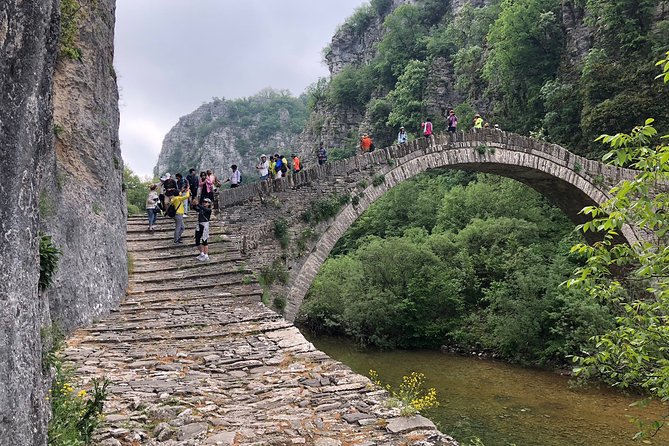
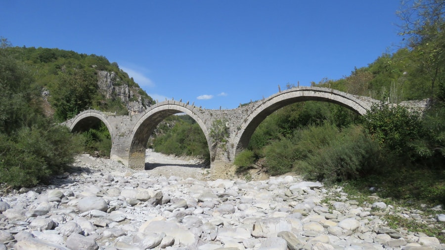
A Vikos gorge hike crosses a region of more than 160 arched stone bridges. The best known is the three-arched Plakidas bridge, also called Kalogeriko, near Kipoi at the southern end of the gorge. Local master craftsmen built the bridges from local stone.
Until modern roads were opened in the 1950s, mountain roads and traditional arched stone bridges connected the 46 or so villages of the Zagori region. Expatriate merchants paid for the bridges through benefactions in the 18th century, and the stone arches replaced older wooden bridges. A Vikos gorge hike therefore belongs to a district whose village links were once stone arches.
Master craftsmen raised the bridges of the greater Zagori area mainly in the 18th and 19th centuries. A Vikos gorge hike in this district sits among stonework of that age. Each bridge has one to three arches, called kamares in Greek. The three-arched Plakidas bridge, also known as Kalogeriko, stands near the village of Kipoi. Kipoi sits at the southern end of the Vikos Gorge, so this bridge belongs to the gorge’s own surroundings.
Kipoi has the lowest altitude of all Zagori villages. It stands on a rocky hill, surrounded by rivers, and it was once the centre of Zagori. Stone bridges ring the village, and old paths lead from it to Elati, Dikorfo, Negades and Tsepelovo with more bridges along the way. A Vikos gorge hike that continues to Kipoi meets these crossings at the southern end of the gorge.
- Kontodimos bridge: This crossing lies at the entrance to Kipoi.
- Milos bridge: This bridge connects the village to an old water mill in the valley.
- Petsonis bridge: This bridge lies at the exit towards Fragades.
- Roof tiles: Village houses carry stone tiles held in place by weight alone, without cement.
No single Vikos gorge hike meets every bridge of the region. The three-arched Kalogeriko bridge and the three bridges around Kipoi are the named examples. After modern roads arrived, the bridges stopped being the main links between villages, but the arches that remain still help travelers cross the rivers and streams of Zagori. Each village is built around a central square with a large church, a plane tree and a public fountain.
What history does a Vikos gorge hike pass through?
A Vikos gorge hike passes through the history of the Zagori villages. They kept self-government under Ottoman rule from 1430, grew wealthy on money sent home by emigrant merchants, built stone mansions, and in September 2023 UNESCO added Zagori to its list of Cultural Landscapes.
Ioannina and Zagori fell to the Turks in 1430. Zagori then had 14 villages, and it agreed a tax in exchange for autonomy, administrative independence and a ban on Turks crossing its borders. The Koinon of the Zagorisians was formed after the treaty of 1431. A Council of Elders called the Demogerontia ran local affairs under a president known as the Vekylis, and a Vikos gorge hike crosses the land this council governed.
Under the treaty, no Ottoman armed unit had the right to set foot in Zagori. The villages of the west were admitted in the 17th century, and by 1678 the total had reached 60. A treaty of 1670 formalised the privileges, known as Surutia, and the Sultan rescinded them fully only in 1868. Zagori was therefore never divided among Turkish landowners, and the villages along a Vikos gorge hike stayed in local hands.
From the 17th century, the economy depended on remittances and bequests from the diaspora, and the flow peaked in the 18th century. Merchants in Romania, Ukraine, Russia and Constantinople paid for cobblestones, fountains, schools, churches and monasteries. The multi-storied manors of the wealthier families date to the late 18th century, and the architecture a Vikos gorge hike passes still reflects that wealth.
The gorge itself shaped the region’s reputation. Healers known as Vikos doctors gathered herbs in the Vikos gorge, so the plants beside a Vikos gorge hike once supplied a trade, and Zagori became a major centre of folk medicine. Their recipes drew on ancient Greek recipes of Hippocrates and Dioscorides. In Monodendri, the brothers Manthos and Georgios Rizaris built the Common School of Greek Studies in 1835, and it still survives.
- Molossians: A small settlement of this ancient tribe stood between Monodendri and Vitsa from the 9th to the 4th century BC.
- Aromanians: The villages of Eastern Zagori, inhabited by Aromanians, entered the treaty in 1480.
- Sarakatsani: Nomadic families appeared in the late 18th century and began as shepherds for local flocks.
- Refuge: Scholars of the Greek Enlightenment sought shelter here after the Sultan’s army destroyed Ioannina in 1820.
Zagori was liberated in 1913 during the Balkan Wars, and the area then lost people to Greek cities. German reprisals in the Second World War burned villages and the monastery of Votsa, and the Greek Civil War of 1946-1949 left the majority of villages deserted. State initiatives since the 1980s have preserved the traditional character of the villages. The 2023 UNESCO listing recognised the stone-built settlements that frame every Vikos gorge hike.
Can a Vikos gorge hike continue to Mount Tymfi?
A Vikos gorge hike can continue to Mount Tymfi, the massif that holds the gorge on its southwestern side. A trail from Mikro Papingo climbs to a mountain hut between Astraka and Lapatos, then on to Drakolimni, the alpine dragon lake near Ploskos.
Tymfi is a mountain in the northern Pindus range, and its highest peak, Gamila, reaches 2,497 m. The massif includes the Vikos Gorge in its southern part. Both belong to the Vikos-Aoos National Park, which accepts over 100,000 visitors per year. A Vikos gorge hike therefore already lies inside the massif, and the higher trails climb out of the same national park.
The simplest ascent for a Vikos gorge hike that continues upward starts at Mikro Papingo, at 980 m on the western side of the mountain. The trail to the mountain hut is about 6 km long and forms part of the Greek national trail O3. Red dots and arrows on rocks and tree trunks mark the way. The hut stands at 1,930 m on the pass between the peaks of Astraka and Lapatos and operates in summer.
From the hut, the lake lies another 2.8 km to the northeast. Drakolimni formed after the glaciers retreated. It covers 1 ha, reaches a maximum depth of 4.95 m and holds alpine newts. Local folktales say dragons lived in the lakes and threw pines and rocks at each other, which created the landscape. Ploskos and Astraka overlook the water, so a Vikos gorge hike extended upward reaches a lake with two peaks above it.
- Gamila: The highest peak lies 6 km southeast of the hut and has no signposts.
- Astraka: This peak stands at 2,436 m and dominates the plateau on its northern face.
- Winter: Winters are particularly harsh, and snow covers the mountain from autumn.
- Other trails: Routes from Vrysochori and Vradeto are longer and steeper, and they suit experienced hikers.
The Tymfi massif carries peaks above 2,400 m, and the Astraka-Gamila plateau still shows moraines left by glaciers about 28,000 years ago. Park law limits activities on the mountain, which lies in the Vikos-Aoos National Park apart from its southernmost part around Astraka. A Vikos gorge hike and a climb to Drakolimni therefore cross two parts of one massif: a deep cut in the rock and a high plateau shaped by ice.
How hard is a Vikos gorge hike?
A Vikos gorge hike crosses steep ground. The main part of the gorge reaches a depth of about 1,350 m, steep slopes dominate the middle zone, and precipitous rocky cliffs dominate the higher zone. Abrupt altitudinal changes shape the whole relief.
A hiking trail descends into the gorge from Monodendri, a village in the municipal unit of Central Zagori built at a height of 1,060 m. Near the village the gorge measures 990 m deep, so a Vikos gorge hike begins far above the floor. The monastery of Agia Paraskevi, founded in 1412, stands close to the village on the edge of the gorge. The village itself was once counted as a neighbourhood of Vitsa.
Gullies dissect both sides of the gorge, and the movement of water detaches rocky material that builds extended screes. Rocky exposures and perpendicular slopes form where the roofs of underground caves and channels collapse. The gorge runs from northwest to southeast. Its slopes expose Eocene limestone in the upper 200 m, Jurassic and Cretaceous limestone below 700 m, and grey Jurassic dolomite in the deepest layers. The Vikos Stream and the Voidomatis River carved the gorge over millions of years.
The trail leads north through the gorge to the springs of the Voidomatis River, and from there paths lead out of the gorge to Papingo on the north side or to Vikos village on the south side. The stream through the major part of the gorge is only seasonal, and it is permanent only at the lowest part. The middle of the main part lies far from road access or villages, and Megas Lakkos, a secondary gorge that is equally deep, crosses it.
- Length: The gorge is 32 km long.
- Walls: The walls range from 120 to 1,350 m deep.
- Northern end: Papingo lies very near the northern end and attracts hikers and mountaineers from around the world.
The Guinness Book of Records lists the gorge as the deepest canyon in the world in proportion to its width, although gorge lobbyists contest that claim. A Vikos gorge hike also sits in a region that has been historically difficult to access because of its mountainous terrain. Mountain roads and arched stone bridges linked the villages of Zagori until modern roads opened there in the 1950s. The land beside the gorge served mainly for pastoralism and firewood.
When is the best season for a Vikos gorge hike?
A Vikos gorge hike follows the mountain climate of Zagori. Papingo, near the northern end of the gorge, lies in a region whose climate is Mediterranean transitioning to Continental, with heavy snowfalls in winter and considerable rainfall and humidity during the other seasons.
The snowcapped Astraka peak of Mount Tymphe towers over Papingo, the village beside the northern end of a Vikos gorge hike. Zagori holds two national parks, one including the river Aoos and the Vikos Gorge, the other around Valia Kalda to the east of the imposing snow-capped Mount Tymphe. In Ioannina, the regional capital that borders the southern point of Zagori, winters are wet and colder than on the coast, with frequent frosts and snowfall now and then. The absolute minimum ever recorded in the city is -13 °C.
Summers in Ioannina are hot and moderately dry, and the absolute maximum recorded in the city is 42.4 °C. The climate there sits on the border between hot-summer Mediterranean (Csa) and humid subtropical (Cfa), with somewhat wetter summers than the nearby coastal areas. The inland location and the elevation of about 500 m on the western shore of Lake Pamvotis temper the heat. The area is famous for the spring water of Zagori, which is sold throughout Greece.
Ioannina is the wettest city in mainland Greece with over 50,000 inhabitants. Deciduous forests surround Papingo, and a mixed broadleaf forest zone covers the valleys and canyons of the middle and lower Pindus. Both villages of Papingo stand at the base of Mount Radovoli, part of the Tymphe massif. The Papingo area holds a wide mix of microenvironments, from streams, rivers and lakes to forests, coppices, pasture and sub-alpine grassland.
- Conifers: Austrian pine and the endemic Greek fir grow at the highest Pindus elevations.
- Highest peak: Mount Smolikas rises to 2,637 m.
- Zagori borders: Mount Mitsikeli, at 1,810 m, forms the southwestern side of Zagori.
The Pindus runs north to south along much of mainland Greece and is known colloquially as the spine of Greece. A Vikos gorge hike lies in its northern part, where the Vikos Gorge, the Aoos Gorge and the valley of Valia Kalda together constitute the National Park of Northern Pindos. The range covers a wide spread of elevations and habitats, from deep canyons to steep mountains. The A2 motorway serves the region and connects it with the rest of Greece.
What do travelers ask about a Vikos gorge hike?
A Vikos gorge hike crosses the core zone of the Vikos–Aoös National Park, in the Zagori region of Epirus. Zagori covers about 1,000 square kilometres, contains 46 villages and is a designated UNESCO World Heritage Site. About 3,400 people live in the area.
Where can walkers stay near a Vikos gorge hike?
A Vikos gorge hike links the villages of Monodendri, Vikos and Papingo. Papingo consists of two villages, Megalo Papingo and Mikro Papingo, with modest lodging provisions and tavernas serving traditional food, coffee and spirits. Monodendri retains much of its traditional stone-built architecture.
How far is Zagori from Ioannina for a Vikos gorge hike?
A Vikos gorge hike from Monodendri begins 41 km north of Ioannina. Ioannina borders the southern point of Zagori, a region in the shape of an upturned equilateral triangle. The city stands 80 km east of the port of Igoumenitsa and 410 km northwest of Athens.
What water is available on a Vikos gorge hike?
A Vikos gorge hike crosses limestone country where surface water is scarce. Limestone dissolves as water percolates through its pores, and an extended underground drainage system with caves and channels has developed. Water appears on the surface only where an impenetrable stratum is met.
Does a Vikos gorge hike stay inside a protected area?
A Vikos gorge hike stays inside the Vikos–Aoös National Park. The gorge lies in the core zone, and 12 km of it belong to that zone. It is a site of major scientific interest because it is in almost virgin condition, and it shelters endangered species.
Does a Vikos gorge hike reach the stone bridges near Kipi?
A Vikos gorge hike can run south from Monodendri to the 18th-century stone bridges near Kipi. More than 160 arched bridges stand in the greater area of Zagori, and they date mainly from the 18th and 19th centuries. The bridge of Plakidas, also called Kalogeriko, has three arches.
Is a Vikos gorge hike possible in winter?
A Vikos gorge hike in winter meets the heavy snowfalls of Zagori, where stone roofs need continual upkeep. The main winter room of a traditional house, the mantzato, has a fireplace, and the walls are up to a meter thick. Monodendri attracts tourism during the Christmas period.
Featured photo: Irini Papalexi, CC BY-SA 4.0, via Wikimedia Commons.