
A Santorini volcano tour crosses the flooded caldera of Santorini by boat to the dark lava islands in its centre, where visitors walk up to the craters and swim in warm volcanic springs. This post covers what a Santorini volcano tour includes, Nea Kameni, the crater walk, the hot springs, the Minoan eruption, the later eruptions, how the volcano works, Kolumbo, how the volcano is watched, Akrotiri, the volcanic beaches, Therasia and the best season. More tours in Greece are listed on the Greece VIP homepage.
Each section ends with a Santorini volcano tour that can be booked online.
What does a Santorini volcano tour include?
A Santorini volcano tour crosses the flooded caldera by boat to the Kameni islands at its centre. The route covers a walk on Nea Kameni, a swim at the warm spring of Palea Kameni, and, on other routes, a stop on Therasia.
The Santorini caldera lies in the southern Aegean Sea, 120 kilometres north of Crete, and sits mostly under water. It measures about 12 by 7 kilometres and reaches a maximum depth of 385 metres, with steep cliffs 300 metres high on three sides. A Santorini volcano tour begins on this water. The boat leaves the cliffs behind and heads for the centre, where two small volcanic islands stand.
Nea Kameni and Palea Kameni stand near the middle of the caldera. Their names mean “New Burnt” and “Old Burnt”. Both are lava islands that a Santorini volcano tour reaches, and they grew from repeated smaller eruptions, which began under the sea. Around them runs a ring of land made up of Santorini itself, known as Thera in antiquity, with Therasia and Aspronisi at the edge. Dozens of tourist boats visit Nea Kameni daily through the summer.
A Santorini volcano tour lands on Nea Kameni, where a gravel path climbs to the top of a volcanic crater 130 metres high. Palea Kameni lies to the south-west and lacks a good harbour, and tourists can swim to it from Nea Kameni. The island contains a hot spring, and thermal waters at the volcano run warmer than the surrounding sea.
- Boat crossing: A Santorini volcano tour runs over a caldera with a maximum depth of 385 metres.
- Nea Kameni: A gravel path leads up to the crater rim.
- Palea Kameni: The island contains a hot spring and lies to the south-west of Nea Kameni.
- Therasia: This island is the second largest of the group and lies north-west of Nea Kameni.
Santorini is dormant but still classed as an active volcano. The Kameni islands last erupted in 1950, and only fumarolic activity, mainly inside the recently active craters, takes place there now. The volcano also ranks as one of the world’s sixteen Decade Volcanoes. For these reasons a Santorini volcano tour works as a visit to a living volcanic field, not only as a boat trip across the water.


What is Nea Kameni on a Santorini volcano tour?
A Santorini volcano tour centres on Nea Kameni, the young volcanic island at the middle of the flooded caldera. The island grew from dacite lava and ash over the past two millennia, is nearly round, and has protected scientific status.
Nea Kameni is an uninhabited Greek island in the Aegean Sea. It sits inside the flooded Santorini caldera, close to the centre. Its name means “New Burnt”, and the neighbouring Palea Kameni is “Old Burnt”. Both islands are made of lava rock and rise from the middle of a caldera that is 12 by 7 kilometres across. The island is nearly barren. A Santorini volcano tour crosses to it by boat.
The two Kameni islands formed over the past two millennia through repeated eruptions of dacite lava and ash. The first eruptions took place under the sea, and later ones kept adding material at the centre of the caldera. Pliny the Elder dated the emergence of a new island to 19 CE, and Cassius Dio noted a small islet in 47 CE.
Major eruptions of the past 300 years took place in 1707–1712, 1866–1870, 1925–1928 and 1939–1941. Its latest activity was a small eruption in 1950 that left a lava dome. Minor and medium-sized, mainly effusive eruptions have built the dark lava shields of both islands. A Santorini volcano tour therefore walks on ground that these eruptions created inside the caldera.
The outline of Nea Kameni is nearly round. Its diameter is about 2 kilometres and its area is 3.4 square kilometres, well above the 0.5 square kilometres of Palea Kameni. For comparison, Therasia covers 9.3 square kilometres and the main island of Santorini covers 75.8 square kilometres. The island is a protected scientific site. The Institute for the Study and Monitoring of the Santorini Volcano (ISMOSAV) monitors it closely.
- Position: A Santorini volcano tour reaches the island at the middle of the caldera, with Palea Kameni to its south-west.
- Age: Repeated eruptions of dacite lava and ash built it over the past two millennia.
- Size: The diameter is about 2 kilometres and the area is 3.4 square kilometres.
- Status: The island is a protected scientific site that ISMOSAV scientists monitor.
Names, dates and status all point the same way: Nea Kameni is young land that scientists keep under watch. The island is small, nearly round and uninhabited, yet it holds the lava of the latest eruptions in the caldera. A Santorini volcano tour centres on it, and the crater walk described next shows what that ground looks like up close.
What does a Santorini volcano tour see on the crater walk?
A Santorini volcano tour sees craters and lava domes on Nea Kameni, dark dacite lava flows, and fumaroles that release steam and gas. The rim path also opens views across the caldera to the steep cliffs, which rise 300 metres on three sides.
The walk follows a gravel path to the top of a volcanic crater 130 metres high. From the top, a full circuit of the rim is possible. The craters on Nea Kameni and Palea Kameni are made of black lava. The island is nearly barren, so a Santorini volcano tour crosses bare lava, with red succulents carpeting the thin soil in summer. The last small eruption, in 1950, involved the extrusion of a lava dome.
Dacite is the rock behind the dark flows. It is a volcanic rock that solidifies rapidly from lava high in silica and low in alkali metal oxides, and it consists mainly of plagioclase feldspar and quartz. Hornblende and biotite dacites are grey or pale brown, while pyroxene-bearing dacites are darker. Dacite also occurs on Nisyros and Thera in Greece, and the lava shields that a Santorini volcano tour crosses grew from it.
A fumarole is a vent that releases hot volcanic gases and vapours without any liquid or solid. The main vapour is steam, formed when groundwater circulates through heated rock. Gases from cooling magma add carbon dioxide, sulfur oxides and hydrogen sulfide. Today only fumarolic activity takes place on the Kameni islands, mainly inside the recently active craters. A sulfur vent on Nea Kameni, called Jorgo, is active and carries the name of King George I of Greece.
The rim also looks out over the caldera walls. On a Santorini volcano tour the cliffs rise 300 metres on three sides, and the caldera measures about 12 by 7 kilometres. Whitewashed villages drape the high walls. The inner side of the wall between Cape Plaka and Athinios exposes non-volcanic rock, while the Kameni islands at the centre are made of lava rock.
- Craters and domes: A Santorini volcano tour crosses black lava craters and the dome that the 1950 eruption extruded.
- Dacite lava: The rock is high in silica and low in alkali metal oxides.
- Fumaroles: Vents release steam, carbon dioxide, sulfur oxides and hydrogen sulfide.
- Caldera walls: The steep wall of the caldera stands 300 metres tall along three edges.
Fumaroles also carry information for scientists. Changes in the composition and temperature of the gases can point to an imminent eruption, and rising sulfur oxide emissions are a robust sign that new magma is moving upward. Active vents can also be a hazard because the gases are hot and poisonous. A Santorini volcano tour therefore sees vents that scientists treat as warning signs.
What are the hot springs on a Santorini volcano tour?
A Santorini volcano tour sits in the flooded caldera, where Palea Kameni holds a hot spring. The thermal water there runs warmer than the surrounding sea, and the island itself is built from pumice and dacite lava erupted from 197 BCE onward.
Palea Kameni lies to the southwest of Nea Kameni, near the centre of the caldera. Its name translates to Old Burnt Island, and plant cover is sparse, limited to succulents. The island covers 0.5 square kilometres, while Nea Kameni covers 3.4. Both Kameni islands are made of lava rock, so on a Santorini volcano tour they read as two dark humps standing in a flooded crater ringed by cliffs.
Palea Kameni, the old island of a Santorini volcano tour, formed during a series of eruptions between 197 BCE and 47 CE. Ancient writers including Strabo and Plutarch record that an island rose from the sea in 197 BCE and received the name Hiera, a name frequently given in antiquity to volcanic mountains. Strabo adds that flames burst out of the sea and that the new island measured 2.4 kilometres around. In 47 CE the Roman historian Cassius Dio noted a small islet, hitherto unknown, close to Thera.
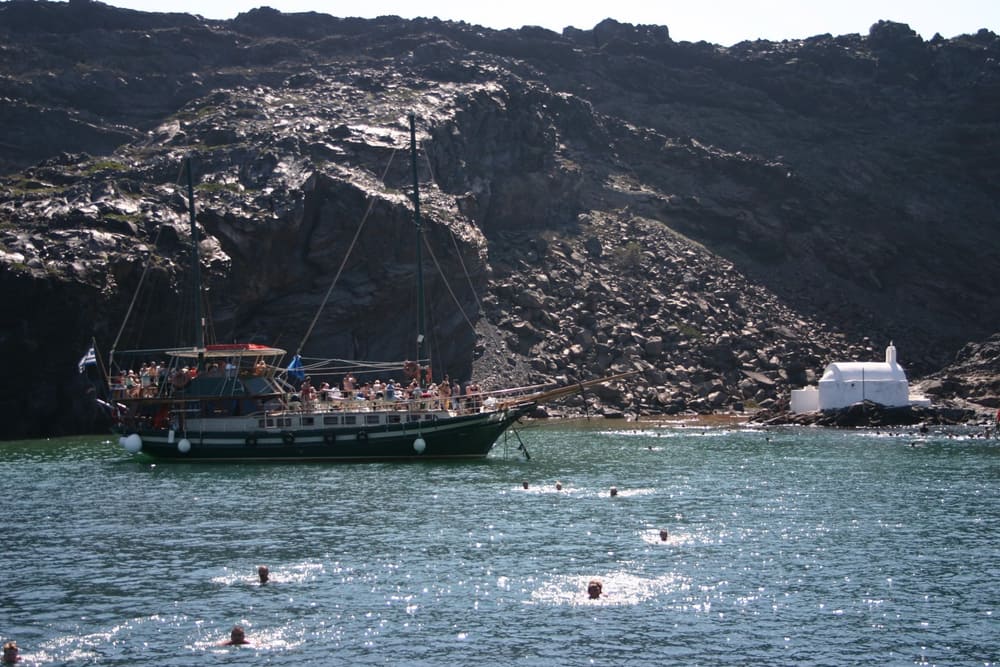
Palea Kameni also contains a hot spring, and thermal waters at the Santorini volcano run degrees warmer than the surrounding sea. Visitors on a Santorini volcano tour meet the island from the water, because it has no good harbour and recreational watercraft rarely stop there. Swimmers can reach it from nearby Nea Kameni. A small church stands among the island’s structures, and a herd of goats lives there.
- Name: Palea Kameni means Old Burnt Island, set against the New Burnt Island of Nea Kameni.
- Rock: Large deposits of pumice and dacite lava make up the island.
- Spring: The hot spring lies on the island, where thermal water runs warmer than the sea around it.
- Setting: A Santorini volcano tour crosses the flooded caldera that surrounds both Kameni islands.
The hot spring is one sign that the volcano beneath the caldera remains active. Fumarolic activity, meaning steam and gas escaping from vents or fissures, is all that continues on the Kameni islands today. A Santorini volcano tour therefore passes a dormant volcano and not an extinct one, and the thermal water of Palea Kameni is part of that evidence.
How did the Minoan eruption shape a Santorini volcano tour?
A Santorini volcano tour crosses the caldera that the Minoan eruption created around 1600 BC. The eruption rated 7 on the Volcanic Explosivity Index, ejected an estimated 28–41 cubic kilometres in dense-rock equivalent, and ranks among the largest volcanic events in human history.
The size of the eruption is hard to pin down, because the bulk of the material fell into the sea. Estimates of the volume range from 13 to 86 cubic kilometres in dense-rock equivalent. Research cruises between 2015 and 2019 narrowed the figure to 28–41. The opening Plinian phase was the largest, and its column rose 30 to 35 kilometres into the stratosphere. A Santorini volcano tour passes the spot, just north of Nea Kameni, where that eruption was centred.
The eruption behind every Santorini volcano tour came in four major phases. On Santorini, a layer of white tephra 60 metres thick covers the old ground level and shows the phases in three bands. The first phase buried buildings under up to 7 metres of pumice and ash, and the later phases brought pyroclastic surges and the collapse of the caldera. The thin first ash layer shows that the volcano gave the local population months of warning.
The collapse of the caldera produced megatsunamis. Tsunamis 35 to 150 metres high devastated the northern coast of Crete, 110 kilometres away, and knocked building walls at Amnisos out of line. Ash layers 3 metres deep lie on Anafi, 27 kilometres east of Santorini. Cores from the seabed and from lakes in Turkey show that the heaviest ashfall went east and northeast, away from the crater that a Santorini volcano tour crosses today.
On Crete, earthquakes destroyed sites such as Petras, and tsunamis 9 metres high swept over Palaikastro. The Minoans recovered quickly, and the period afterwards is seen as the high point of Minoan culture, with new palaces at Zakros and Phaistos. The long-term effect remains debated. So does the date: radiocarbon points to the late 17th century BC, while archaeology tied to Egyptian chronology argues for a date between circa 1550 and 1480 BC.
- Date: The radiocarbon age is roughly a century older than the date from archaeological dating.
- Column: The plume stood 30 to 35 kilometres high and reached the stratosphere.
- Tsunami: Tsunamis hit the northern coast of Crete, 110 kilometres from the volcano.
- Caldera: The rim seen on a Santorini volcano tour marks the collapse that the third and fourth phases carried out.
The eruption explains why a Santorini volcano tour takes place in a flooded crater and not on a cone. The same cliff face frames a Santorini sunset tour, and the layers of lava and tephra in it record the eruption history. Scholars still argue about the exact year, but the eruption’s role in forming the caldera is clear, and so is the quick recovery of the Minoan world on Crete.
Which later eruptions does a Santorini volcano tour recall?
A Santorini volcano tour recalls the eruptions that built Palea Kameni and Nea Kameni after the Minoan collapse. They began in 197 BCE, produced major events in 1707–1712, 1866–1870, 1925–1928 and 1939–1941, and ended with a small lava dome eruption in 1950.
The caldera that a Santorini volcano tour crosses did not stay empty after the Minoan eruption. Palea Kameni and Nea Kameni formed from smaller eruptions at the centre of the caldera, and the first of these were submarine. Pliny the Elder reported a new island on 8 July in the year of the consulship of M. Junius Silanus and L. Balbus, which dates to 19 CE. The next recorded event, in 726, was a submarine explosive eruption of pumice and lava.
Activity reported in the 1570s accompanied the growth of Nea Kameni, the sister island of Palea Kameni. Over the last 300 years, major eruptions came in 1707–1712, 1866–1870, 1925–1928 and 1939–1941. Each added dacite lava and ash. A Santorini volcano tour crosses the water around the dark lava shields that these repeated eruptions built, and the two islands together formed over the past two millennia.
The last small eruption came in 1950 and pushed out a lava dome. Since then, only fumarolic activity has been recorded, primarily inside the recently active craters. Santorini is dormant but still counts as an active volcano, and it is designated one of the world’s sixteen Decade Volcanoes. A Santorini volcano tour therefore recalls a volcano whose last eruption on the Kameni islands lies decades in the past.
- Palea Kameni: Eruptions between 197 BCE and 47 CE formed the island.
- Pliny’s report: A new island emerged in 19 CE, according to Pliny the Elder.
- Submarine blast: In 726 an explosive eruption under the sea produced pumice and lava.
- Last event: The 1950 eruption extruded a lava dome on the Kameni islands.
The Kameni islands show that the volcano rebuilt itself after the Minoan collapse, as it did in earlier caldera cycles. Over the past two millennia, repeated dacite eruptions raised two islands from the water, and the last small eruption came in 1950. A Santorini volcano tour recalls that history on the water, with the old burnt island and the new one lying side by side.
How does the volcano on a Santorini volcano tour work?
A Santorini volcano tour visits a volcano created by plate tectonics. The African plate slides beneath the Aegean subplate of the Eurasian plate, and Santorini is the part of the South Aegean Volcanic Arc with the highest activity, a chain with Methana, Milos and Nisyros.
The engine sits south-west of Crete, where the Hellenic subduction zone drives the volcanism. The oceanic crust of the northern African plate is subducted under Greece and the Aegean Sea, which is thinned continental crust. The African plate descends at a rate of up to 5 cm per year in a north-easterly direction, and the descent causes earthquakes at depths of 150–170 km. A Santorini volcano tour stands on the surface result of that slow collision.
The arc is a chain of volcanoes in the South Aegean Sea. It is about 450 km long and 20 km to 40 km wide, and it runs from the Isthmus of Corinth on the Greek mainland to the Bodrum peninsula on the Turkish mainland. The list of its volcanoes includes Sousaki, Aegina, Methana, Milos, Santorini, Kolumbo, Kos, Nisyros, Yali and Akyarlar. Volcanologists place the Santorini volcano tour setting inside this long chain, not apart from it.
Magma chambers explain the repeating pattern of the volcano. Lava flows and small explosive eruptions build cones, which are thought to impede the flow of magma to the surface. That allows large magma chambers to form, where the magma evolves to more silicic compositions. A large explosive eruption then destroys the cone. The Kameni islands in the centre of the lagoon are the latest cone of this kind, with much of them hidden beneath the water, and a Santorini volcano tour visits them.
- Plate boundary: The Hellenic subduction zone south-west of Crete is the source of the volcanism on Santorini.
- Arc members: Methana on the mainland of Greece, Milos, Santorini and Nisyros are the active volcanoes of the arc.
- Recent activity: Only Santorini, Kolumbo and Nisyros have erupted or shown significant unrest during the past 100 years.
- Lava islands: The Kameni islands, which a Santorini volcano tour visits, are made of lava rocks.
A Santorini volcano tour therefore visits one working part of a long machine. Subduction supplies the setting, the magma chambers supply the eruptions, and the Kameni islands show the newest cone. Methana, Milos and Nisyros share the same setting, which makes Santorini one member of a chain and not a lone event. The International Union of Geological Sciences lists the Quaternary Santorini Caldera among its 100 geological heritage sites.
What is Kolumbo, the undersea neighbour of a Santorini volcano tour?
A Santorini volcano tour stays above water, but Kolumbo lies below it. Kolumbo is an active submarine volcano about 8 km north-east of Cape Kolumbo on Santorini, about 3 km wide, with a crater 1.5 km across. It first broke the sea surface in 1649–1650.
Kolumbo is the largest of a line of about twenty submarine volcanic cones that extend north-east from Santorini. The caldera of Santorini lies in the centre of the Christiana-Santorini-Kolumbo volcanic field, which also holds the extinct Christiana volcano and the Kolumbo volcanic chain. The Global Volcanism Program of the Smithsonian Institution treats Kolumbo as part of the Santorini volcano, although at least one source holds that it is a separate magmatic system. A Santorini volcano tour thus sits inside a larger volcanic field.
The eruption of 1650 came when the growing cone reached the surface. It sent pyroclastic flows across the sea to the shores and slopes of Santorini, where about seventy people died along with animals. A small ring of white pumice formed and was soon worn away by waves. The volcano then collapsed into its caldera and triggered a tsunami that damaged islands up to 15 km away. A Santorini volcano tour crosses the water next to this old blast.
Exploration came much later. In 2006 an expedition by NOAA Ocean Explorer, equipped with remotely operated vehicles, sampled and mapped the seafloor deposits. It found a field of hydrothermal vents in the north-eastern part of the crater, covered by a thick bacterial community. Superheated, metal-enriched water measured at up to 224 °C has built chimneys of sulfide and sulfate minerals up to 4 m tall, apparently grown since the 1650 event. The expedition also began new seismic air-gun techniques to measure the pumice and ash on the sea floor.
- Crater floor: The floor lies about 505 m below the sea surface on average.
- Crater rim: The highest parts of the rim are now about 10 m below sea level.
- Magma chamber: A previously undetected chamber, 2 to 4 km below sea level, was announced in October 2022 and is gradually filling with melt.
Kolumbo shows that the volcanic system around Santorini does not end at the coast. A Santorini volcano tour covers the visible Kameni islands, while Kolumbo holds the submerged record of a 17th-century eruption and an active vent field. Scientists state that an eruption is not imminent, yet the chamber poses a threat, and they recommend real-time monitoring of the volcano.
How is the volcano watched on a Santorini volcano tour?
A Santorini volcano tour visits a volcano that scientists track from the ground and from space. GPS instruments registered renewed deformation around the caldera in 2011 and 2012, and satellite radar analysis showed that molten rock had swollen the magma chamber below.
The unrest began quietly. Small tremors and reports of strange gaseous odours over the course of 2011 and 2012 prompted satellite radar analyses. Those analyses revealed the source of the symptoms: the magma chamber under the volcano had been swollen by a rush of molten rock, between 10 and 20 million cubic metres, from January 2011 to April 2012. A Santorini volcano tour in the years since has visited a volcano that took in that new melt.
Two methods carry the story. GPS instruments registered renewed deformation around the caldera, which showed that the ground itself was moving. Satellite radar analysis traced the tremors and odours to the swollen chamber below. The first signals were small tremors and reports of strange odours, and the instruments then confirmed that the cause lay underground. Scientists have also studied the sea floor around Santorini extensively since 1975, so the record of the Santorini volcano tour setting runs well beyond the 2011–2012 episode.
For visitors the point is the present state of the volcano. Santorini is dormant, yet it remains an active volcano. The last eruption on the Kameni islands was in 1950, and now only fumarolic activity takes place, primarily inside the recently active craters. At the current active crater, steam and carbon dioxide are emitted. A Santorini volcano tour meets the volcano in this quiet state.
- Ground rise: Parts of the island’s surface rose out of the water by a reported 8 to 14 centimetres.
- Energy: Scientists say that the injection of molten rock equalled 20 years’ worth of regular activity.
- Gas: Steam and carbon dioxide are emitted at the current active crater visited on a Santorini volcano tour.
- Observation: High walls, a sunny climate and good observation conditions have made Santorini a magnet for volcanologists.
The 2011–2012 episode shows how the watching works. Tremors and odours raised questions, and GPS and satellite radar supplied the answers. For a Santorini volcano tour, the result is a volcano under scientific watch, with its last eruption in 1950 and gas still rising at the crater. Researchers recommend the same approach for Kolumbo, where they call for real-time monitoring.
What does a Santorini volcano tour show of Akrotiri?
A Santorini volcano tour shows Akrotiri as the Bronze Age town that the eruption buried under volcanic ash. The ash sealed multi-storey houses, streets, drains and painted walls in place, and no human remains turned up, which points to an orderly departure before the eruption.
Akrotiri began as a small fishing and farming village, and the earliest signs of habitation reach back to the fifth millennium BCE. Its position on the main sailing route between Cyprus and Minoan Crete made it a stop in the copper trade, and moulds and crucibles show that metal was worked there. A Santorini volcano tour that reaches Akrotiri links this trading town to the volcano, because the eruption that ended the town also left a large caldera.
The Theran eruption destroyed the settlement in the 16th century BC and buried it in ash. Radiocarbon dating places the eruption between 1620 and 1530 BC, and the exact year is not known. No human skeletal remains have been found, and only a single gold object came to light, hidden beneath flooring. That pattern indicates an orderly evacuation with little or no loss of life. A Santorini volcano tour can tell the burial as a story of escape.
Like the Roman ruins of Pompeii, the site is remarkably well preserved. Walls stand as high as eight metres, stone staircases are still intact, and houses held huge ceramic storage jars called pithoi. Wooden furniture rotted away inside the ash, but the ash kept its shape, and plaster poured into those hollows produced casts of beds, tables, chairs and stools. A Santorini volcano tour sees only the southern tip of the town, which is all that has been uncovered.
The wall paintings are better preserved than the Minoan frescoes of Knossos, which have nearly all survived as small fragments. The palette runs through white, yellow, red, brown, blue and black. One house held two antelopes, a man holding fish strung by their gills, and a flotilla of pleasure boats with leaping dolphins. The Spring Fresco, found in 1970, was the first to turn up perfectly preserved and still standing where it was installed. On a Santorini volcano tour, these paintings put people into the eruption story.
- Excavation: Spyridon Marinatos began the modern excavation in 1967, and two seasons were needed to establish the extent of the city.
- Method: Marinatos tried tunnelling into the pumice, but the technique was later abandoned.
- Museum: The excavated objects are displayed in the Museum of Prehistoric Thera, away from the site.
Christos Doumas took over the excavations in 1975, after the death of Marinatos. Digging stopped between 2005 and 2016 for lack of funding and then resumed with sponsor support. A Santorini volcano tour sets this slow archaeological work beside the volcano, so the burial of Akrotiri and the shape of the caldera read as one event.
Which volcanic beaches does a Santorini volcano tour pass?
A Santorini volcano tour passes beaches that take their colour from the volcano. Red Beach has sand of crushed red and black volcanic rock, Kamari is covered with black pebbles, and Perissa lies near the Mesa Vouno rock. Slides have made parts of Red Beach inaccessible since 2013.
Red Beach is a volcanic sand beach on Santorini, known for its red-hued sand, which owes its colour to oxidised iron. The sand is made of black and red pulverised rock from the nearby Santorini caldera. The beach is reached from Akrotiri, and the area is prone to landslides. A Santorini volcano tour that passes Red Beach sees the colour of the sand record the chemistry of the lava.
Kamari is a coastal village on the southeastern part of Santorini, with 1,065 residents at the 2021 census, 8 km from the capital Fira. Residents of nearby Episkopi Gonias built it after a devastating earthquake in July 1956 almost flattened their own village. Its beach is covered with black pebbles and is the longest on the island, running from Monolithos to the foot of Mesa Vouno. A Santorini volcano tour ties Kamari to the volcano through that black shore.
Perissa is a village 13 km southeast of Fira, near the Messa Vouno rock, with 725 permanent inhabitants at the 2021 census. Its beach faces the Aegean. The remnants of the Early Christian church of Saint Irene lie there, and the contracted form of that name became the present name of the island. A Santorini volcano tour that names Perissa therefore links a beach to the origin of the name Santorini.
- Red Beach: Oxidised iron gives the red hue to a sand of pulverised volcanic rock.
- Kamari: Its beach of black pebbles is the longest on the island.
- Perissa: The village stands near the Messa Vouno rock, and its beach faces the Aegean.
- Warm water: The water at the darker beaches is significantly warmer because the lava acts as a heat absorber.
Beach colour on Santorini depends on which geological layer is exposed, so a Santorini volcano tour can read the shoreline as a cross-section of the island’s volcanic history. The inner coast around the caldera is a sheer precipice of more than 300 metres at its highest, with layers of solidified lava stacked on each other, while the outer beaches are smooth and shallow. A Santorini volcano tour joins these two views of one volcano.
What does a Santorini volcano tour see at Therasia?
A Santorini volcano tour sees Therasia as the second largest island of the caldera group, lying north-west of Nea Kameni. The eruption split it from Santorini, and it now has five villages and 249 residents at the 2021 census.
Therasia, also written Thirasia, is the second largest island in the volcanic group of Santorini in the Greek Cyclades. The largest by far is Thera, the main island. Therasia lies north-west of Nea Kameni, the small island formed in recent centuries by volcanic activity, which marks the centre of the group. A Santorini volcano tour that circles the caldera meets Therasia as a section of the ring around the water-filled crater.
Before the Minoan eruption, the caldera formed a nearly continuous ring, and the only entrance lay between the islet of Aspronisi and Thera. The eruption destroyed the sections of the ring between Aspronisi and Therasia, and between Therasia and Thera, which created two new channels. Thera and Therasia were separated by the Thera eruption in this way. On a Santorini volcano tour, those two channels show where the ring once closed and where the sea now flows through.
Therasia belongs to the municipal unit of Oia and to the municipality of Santorini, so a Santorini volcano tour stays inside one municipality. That municipality covers two inhabited islands, Santorini and Therasia, and the uninhabited islands of Nea Kameni, Palaia Kameni, Aspronisi, Anydros and Christiana. The two inhabited islands share services: electricity for both comes principally from the power station at Monolithos on Santorini, and one municipal company handles water supply and sewage for both.
- Manolas: The largest village on Therasia, with 140 residents at the 2021 census.
- Potamos: A village of 74 residents at the 2021 census.
- Agia Eirini: A village of 28 residents at the 2021 census.
- Agrilia: A settlement of 5 residents at the 2021 census.
- Ormos Korfou: A settlement of 2 residents at the 2021 census.
Therasia shows that the caldera is a ring of islands and that the same eruption that buried Akrotiri broke the ring apart. The small population and five villages of the island stand against the large caldera around Nea Kameni. A Santorini volcano tour that includes Therasia covers both the geology of the rim and the settled life on the second largest island of the group.
When is the best season for a Santorini volcano tour?
A Santorini volcano tour meets the meltemi at its peak in July and August, when the wind blows with its highest frequency, plus the dry summer heat. The shoulder months around that peak bring milder weather and fewer visitors, while the wetter winter brings rain to the island.
The National Observatory of Athens describes the climate of Santorini as hot semi-arid, with Mediterranean traits such as dry summers and relatively wetter winters. The average annual rainfall is around 270 mm, and the average annual temperature is around 19 degrees Celsius. The island lies in a rain shadow between the mountains of Crete and the Peloponnese, so the dry summer brings the driest weather for a Santorini volcano tour. Early-morning fog settles on the ground as dew. The island has no rivers and very little surface water in summer.
The meltemi is the strong, dry north wind of the Aegean Sea. It blows from late spring to mid-September, and its highest frequency falls in July and August. The wind peaks in the afternoon, can fade at night, and can also last for days without a break. It rises in clear weather without warning and can reach force 7 to 8 on the Beaufort scale. At that force, yachts and inter-island ferries can be unable to sail, so the wind matters for any Santorini volcano tour that crosses open water.
The same wind cools the air. It tempers the fierce summer heat of the region and keeps temperatures in the Aegean lower than those of the Ionian Sea or the mainland. The heat on bare lava is a separate matter from the breeze. The island has dark lava beaches where the water is significantly warmer, because the lava acts as a heat absorber. The Kameni islands are cones built from lava flows and small explosive eruptions, so a Santorini volcano tour crosses the same dark rock under the summer sun.
Tourism is the primary industry of Santorini, particularly in the summer months, and an estimated 2 million tourists visit the island each year. The ferry link with Piraeus runs daily all year long, with up to 5 direct crossings in summer, and airlines add chartered flights during the summer. The cooler months therefore bring fewer crossings, fewer charter flights and a quieter island, with wetter winter weather as the trade-off for that quiet. A traveler who values quiet picks the weeks outside July and August for a Santorini volcano tour.
- Summer: The meltemi reaches its highest frequency in July and August, which sets the wind for a Santorini volcano tour in the dry summer.
- Winter: Winters are relatively wetter than the dry summers, which brings rain to the island.
- Wind season: The meltemi blows from late spring to mid-September, and another source extends the season to October.
- Lava heat: Dark lava acts as a heat absorber, so the water at the darker beaches of the island is significantly warmer.
Each season trades one factor for another. Summer brings dry weather, the peak of the wind season and the heat of dark lava. The weeks outside July and August bring less wind and a quieter island, while winter brings rain. A traveler who weighs these three factors can pick the months that suit a Santorini volcano tour, because the crater, the lava and the caldera stay the same in every season. Only the weather and the crowds around them change from month to month.
FAQ: What do travelers ask about a Santorini volcano tour?
A Santorini volcano tour raises four common questions: where the boats leave from, whether the volcano is still active, how the volcano links to the Atlantis legend, and whether the trip pairs with another sea trip on a separate day.
Where does a Santorini volcano tour leave from?
Tour boats for Nea Kameni depart from Skala, the old port of Santorini, below the town of Fira on the caldera edge. Visitors reach the port from Fira by the zigzag footpath, on foot or on donkeys, or by the steep cable car whose lower terminal stands by the port. Santorini has a second port, Athinios, which serves the ferries.
Is the volcano still active on a Santorini volcano tour?
The volcano is dormant at present, yet steam and carbon dioxide still rise from the active crater on Nea Kameni. Eruptions at that island continued through the twentieth century, and the last ended in 1950. The ash from past eruptions also forms the soil of the island’s vineyards, which a Santorini wine tour on another day can show up close.
Is a Santorini volcano tour linked to the Atlantis legend?
The link is a theory. The Minoan eruption has been considered a possible inspiration for the story of Atlantis, which comes from the dialogues Timaeus and Critias by Plato. Current archaeological research does not support the content of those ancient stories, so a Santorini volcano tour visits real volcanic ground at the centre of the caldera and not a lost city.
Can a Santorini volcano tour pair with a Santorini catamaran cruise on another day?
Yes, the two trips fit on separate days, with no overlap. The caldera is 18 km long from Cape Akrotiri in the south to the northern cape, so a sea day on a Santorini catamaran cruise adds a wider view of the water around Nea Kameni, Thirasia and Aspronisi. In summer, the meltemi gives leisure sailors a good, steady sailing wind.
Featured photo: Norbert Nagel, CC BY-SA 3.0, via Wikimedia Commons.