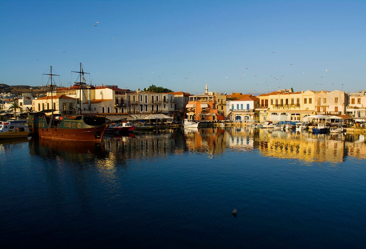
A Rethymno tour explores Rethymno, the old Venetian and Ottoman port town on the north coast of Crete, and the monasteries, villages and gorges of the land behind it. This post covers what a Rethymno tour includes, the old town, the Fortezza, the Venetian harbour, Arkadi Monastery, the villages inland, the gorges, Preveli and Mount Ida, and the best season. It is one of the best tours in Greece on Greece VIP.
Each section ends with a Rethymno tour that can be booked online.
What does a Rethymno tour include?
A Rethymno tour covers the city of Rethymno on the island of Crete, the capital of Rethymno regional unit. It takes one of two forms: a walk through the Venetian old town, or a day trip out into the regional unit and its countryside.
The city lies between Heraklion and Chania and has more than 35,000 inhabitants. Venetian conquerors set up a commercial station here between the two larger cities, and the town gained its own bishop and nobility. Every Rethymno tour starts from that Venetian past.
The old town is the base for a walking Rethymno tour. It is called palia poli in Greek, was almost entirely built by the Republic of Venice, and counts among the best-preserved old towns in Crete.
A day-trip Rethymno tour leaves the city for the rest of the regional unit. Rethymno is one of the four regional units of Crete, and it has five municipalities: Agios Vasileios, Amari, Anogeia, Mylopotamos and Rethymno. Tourism is its main income, while the countryside lives on agriculture and herding.
- Walking tour: The old town is covered on foot, past Venetian and Ottoman buildings.
- Day trip: A longer route reaches beyond the city into the regional unit.
- Capital: The city of Rethymno is the capital of the regional unit.
Both kinds of Rethymno tour rest on the same history. The town holds the Venetian and Ottoman layers in a small area, and the regional unit holds the countryside around it.


What does a Rethymno tour see in the old town?
A Rethymno tour in the old town sees Piazza Rimondi, the Venetian Loggia, the Neradje Mosque and the narrow streets between them. The Republic of Venice built almost all of this quarter, and the Ottoman Empire took the town in 1646.
The town kept its old aristocratic appearance. Buildings from the 16th century stand along lanes with arched doorways, stone staircases and Byzantine remains. A Rethymno tour on foot follows these narrow streets from one monument to the next, so the Venetian layout shapes the whole route.
Piazza Rimondi is one of the monuments of the old town, and the Venetian Loggia is another. The Loggia now houses the information office of the Ministry of Culture and Sports. A Rethymno tour stops at both to show how Venetian Rethymno worked as a commercial station between Heraklion and Chania, with its own bishop and nobility.
The Neradje Mosque is another monument on the route. It now serves as the Municipal Odeon arts centre. The Ottoman Empire conquered the town in 1646 during the Cretan War, and the town, called Resmo in Turkish, became the centre of a sanjak, an administrative part of a province.
- Piazza Rimondi: The square is named among the monuments of the old town.
- Loggia: The Venetian Loggia houses the information office of the Ministry of Culture and Sports.
- Neradje Mosque: The mosque is now the Municipal Odeon arts centre.
Venice built the old town, and from 1646 the Ottoman Empire ruled it. A Rethymno tour that stays in the old town therefore reads as a record of both rulers, written in staircases, doorways, a loggia and a mosque.
Why does a Rethymno tour stop at the Fortezza?
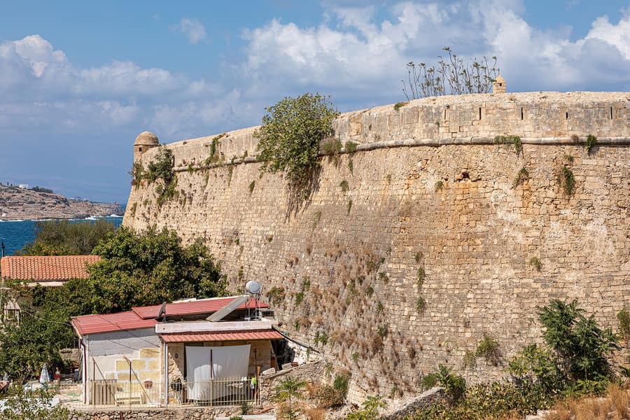
A Rethymno tour stops at the Fortezza because it is the Venetian citadel of the city, built on Paleokastro hill after the Ottomans sacked Rethymno in 1571. It is one of the best-preserved castles in Crete and holds a mosque inside its walls.
The first city walls were begun on 8 April 1540 to the designs of the architect Michele Sanmicheli, but they were not strong enough to withstand a large assault. When Uluç Ali Reis attacked in 1571, the Ottomans captured and sacked the city. Cyprus fell that year too, which left Crete as the largest Venetian overseas possession. Venice then ordered new fortifications to protect Rethymno and its harbour.
The new fortress rose on Paleokastro hill, a name meaning Old Castle, where ancient Rhithymna had its acropolis. The military engineer Sforza Pallavicini designed it on the Italian bastioned system. Construction began on 13 September 1573 under the master builder Giannis Skordilis and was complete by 1580.
A Rethymno tour at the Fortezza follows an irregular plan whose walls total 1,307 metres. Four demi-bastions stand in the walls: St Nicolas, St Paul, St Elias and St Lucas. Inside is the Mosque of Sultan Ibrahim, formerly the Cathedral of St Nicolas, which the Ottomans converted after taking the citadel in 1646.
- Walls: The walls have a total length of 1,307 metres.
- Bastions: The four demi-bastions are St Nicolas, St Paul, St Elias and St Lucas.
- Mosque: The Mosque of Sultan Ibrahim was formerly the Cathedral of St Nicolas.
The Fortezza was too small to house the whole city, so it became a citadel for the Venetian administration, and the inhabitants were to use it only in case of an Ottoman invasion. That happened in 1646, when the population took refuge inside and the Venetians surrendered on 13 November. A Rethymno tour treats it as the military counterpart of the old town.
What does a Rethymno tour show at the Venetian harbour?
A Rethymno tour shows the small Venetian harbour and the Venetian lighthouse at the tip of a stone fortification. Venice made Rethymno a trading station between Heraklion and Chania, and the harbour belongs to the old town that the Republic of Venice almost entirely built.
The harbour sits among arched doorways, stone staircases and narrow streets that date from the 16th century. The Venetians chose Rethymno for a commercial station when they ruled the island, and the town gained its own bishop and nobility. A Rethymno tour reads the harbour as part of that history, because the commercial station started a period of growth for the town.
The lighthouse stands at the tip of a stone fortification. A lantern and gallery sit on a stone column, and the column rests on a square base of stone. The top third of the column is round, and the bottom two-thirds are octagonal. The Venetian lighthouse of the port is the second largest Egyptian lighthouse of Crete, after the lighthouse of Chania.
- Harbour: The small Venetian harbour belongs to the old town.
- Lighthouse: The second largest Egyptian lighthouse of Crete.
- Trade: A Rethymno tour traces the Venetian station between Heraklion and Chania.
The harbour links the town to both of its early rulers. The Ottoman Empire conquered Rethymno in 1646 during the Cretan War, and the town, called Resmo in Turkish, became the centre of a sanjak, an administrative part of a province. A Rethymno tour therefore connects the waterfront to Venice first and to the Ottoman Empire after.
Why does a Rethymno tour visit Arkadi Monastery?
A Rethymno tour visits Arkadi Monastery because the site holds a central memory of the Cretan revolt of 1866. In November of that year, Cretans sheltering inside blew up barrels of gunpowder rather than surrender, and the explosion drew the attention of the rest of the world.
Arkadi is a Greek Orthodox monastery on a fertile plateau to the southeast of Rethymno, and a thick, high wall surrounds it. The church dates from the 16th century and follows the Renaissance Revival style, with Roman and Baroque elements. Its facade has four pairs of Corinthian columns, an archway between each pair, a clock at the centre and a Gothic obelisk at each end.
The revolt was a three-year uprising against Ottoman rule, proclaimed on 21 August 1866. On 8 November, an Ottoman army of 15,000 men and 30 cannons reached the hills around the monastery, where 943 Greeks, mostly women and children, had taken refuge. The Cretans answered the last demand to surrender with gunfire. A Rethymno tour tells this account at the place where it happened.
- Church: A basilica with two naves, one for the transfiguration of Christ and one for Saint Constantine and Saint Helen.
- Refectory: Built in 1687, it holds marks of bullets and swords in the wood of its tables and chairs.
- Memorial: An octagonal former windmill, west of the monastery, commemorates the Cretans who died.
The monastery became a national sanctuary in honor of the Cretan resistance, and Rethymno holds a festival in memory of its destruction on 7 and 8 November. Volunteers from Serbia, Hungary and Italy came to the island, and Victor Hugo wrote letters about the tragedy of Arkadi. A Rethymno tour presents this record as the reason the monastery stands in Cretan memory.
Which villages does a Rethymno tour pass inland?
A Rethymno tour passes inland villages with local history: Argyroupoli, on the site of ancient Lappa; Spili, the seat of the Agios Vasileios municipality; and Margarites, the birthplace of Anna Apostolaki, later director of the National Museum of Decorative Arts.
Argyroupoli is a village in the municipality of Rethymno, at an altitude of 260 metres, with a population of 313 in the 2021 census. It stands on the site of the ancient city of Lappa. The Romans took Lappa by storm and almost entirely destroyed it, and the emperor Augustus restored it and gave its citizens their freedom and the right of coinage. A Rethymno tour reads the later names too: Stimboli, Polis, and Silver City, used until 1669 and revived in 1878.
Spili is a village in the Rethymno regional unit and the seat of the Agios Vasileios municipality. The 2011 reform formed the municipality from two former municipalities, Foinikas and Lampi, and it covers 359.171 square kilometres. Margarites lies in the province of Rethymno. Apostolaki was born there in 1880, and as a curator she travelled to remote villages in Crete by mule to collect embroidery samples and costumes.
- Argyroupoli: A village on the site of ancient Lappa.
- Spili: The seat of the Agios Vasileios municipality.
- Margarites: A Rethymno tour reaches the birthplace of Anna Apostolaki.
These villages show how the Rethymno countryside is organised. The regional unit has five municipalities: Agios Vasileios, Amari, Anogeia, Mylopotamos and Rethymno. The countryside rests on agriculture and herding, and olive oil is a notable product. A Rethymno tour crosses this inland countryside.
Which natural sights does a Rethymno tour reach?
A Rethymno tour reaches the Kourtaliotiko Gorge, Preveli and its palm grove, and Mount Ida in the Psiloritis massif, the island’s highest peak at 2,456 metres. The Idaean Cave on its slopes is where legend says Zeus was born.
The Kourtaliotiko Gorge lies on the southern side of western Crete, where the Kourtaliotiko River flows south between the Kouroupa and Xiron mountains. A road runs through it from the village of Koxare to Asomatos. A small church of Agios Nikolaos and a 40-metre-high waterfall stand in the gorge, and its cliffs give the Lammergeier vulture a roosting site.
Preveli is a location on the south coast of Crete, in the Rethymno region, known for its monastery. Below the monastery, a beach and lagoon lie at the mouth of the Kourtaliotiko gorge, with a glade of Cretan date palms behind the sand. A fire in August 2010 destroyed a large share of the palm grove, which regrew by 2011.
Mount Ida stands in the Rethymno regional unit, and a natural park that includes it belongs to UNESCO’s Global Geoparks Network. The Idaean Cave on its slopes was venerated by Minoans and Hellenes alike and was rededicated to Zeus in Greek times. Votive seals and ivories were found in the cave, which was known as a place of initiations.
- Nida plateau: Stone shepherd huts stand to the east.
- Zominthos: The highest-altitude Minoan villa ever found stands here.
- Skinakas: An observatory sits on this secondary peak.
The gorge leads on to the beach at Preveli, so the first two sights link on a Rethymno tour. Mount Ida stands apart as the highest ground on Crete. Together the three show Rethymno beyond its old town: a gorge, a seaside palm grove and a mountain tied to Zeus.
When is the best season for a Rethymno tour?
A Rethymno tour meets hot, dry summers and mild, wet winters, because the low-lying areas of Crete have a Mediterranean climate. Rethymno’s daytime highs run from 55 degrees Fahrenheit in January to 86 degrees in July and August.
Summer in the low-lying areas of Crete is sunny and dry, and rain falls as showers or thunderstorms. Rethymno’s highs reach 86 degrees Fahrenheit in July and August, with lows of 70. Heatwaves can occur, but they stay mild on the coast, where the cooler sea and the sea breeze moderate the heat. The etesian winds blow until October.
Winters are wet, and the rain is persistent. Rethymno’s January and February highs stand at 55 degrees Fahrenheit, and January lows reach 45. Snow that falls on the lowlands does not last long. Crete’s higher mountains differ: they have an alpine Mediterranean climate with a harsh winter and abundant snowfall, which matters for a Rethymno tour toward Mount Ida.
Spring and autumn sit between these extremes. April highs reach 64 degrees Fahrenheit, September highs 81, October highs 72 and November highs 64. The Hellenic National Meteorological Service publishes a climate atlas recording more than 3,250 hours of sunshine a year in south Crete, where Preveli lies. The Campbell-Stokes recorders behind it underestimate annual sunshine by around 200 hours.
- Summer: Highs reach 86 degrees Fahrenheit under dry, sunny skies.
- Autumn: Highs drop from 81 degrees to 64 by November.
- Winter: Rain is persistent, with highs of 55 degrees.
The climate shapes a Rethymno tour in every season. Summer suits the coast and the sea breeze, winter brings persistent rain, and the months between them sit in the middle. Mount Ida needs separate thought, because the higher parts of Crete’s mountains keep their own alpine climate with winter snow.
What do travelers ask about a Rethymno tour?
A Rethymno tour raises practical questions about arrival, population, study life and neighbouring routes. Rethymno is a city on Crete and the capital of its regional unit. The four answers below take each of these questions in turn.
How do travelers reach Rethymno for a Rethymno tour?
Chania International Airport lies 14 kilometres from Chania and has a bus link to Rethymnon. Heraklion International Airport is the main and busiest airport on Crete. Rethymno sits between Heraklion and Chania, a position the Venetians chose for a commercial station.
How big is the city on a Rethymno tour?
Rethymno is the capital of the Rethymno regional unit and has more than 35,000 inhabitants, with nearly 40,000 in the municipal unit. The municipality formed in the 2011 government reform from four former municipalities: Arkadi, Lappa, Nikiforos Fokas and Rethymno.
Which university stands in the city of a Rethymno tour?
The Rethymno Campus of the University of Crete holds the School of Philosophy, the School of Education, the School of Social, Economics and Political Sciences and the University Library. About 8,000 students study at Galos, where the campus is located.
Can a Rethymno tour pair with a Samaria Gorge tour on another day?
Yes, on separate days. The Samaria Gorge lies in the regional unit of Chania, so a Samaria Gorge tour is a different outing from a Rethymno tour. The gorge became a national park in 1962. Visits end on 31 October.
Featured photo: AfraEmm, CC BY-SA 4.0, via Wikimedia Commons.