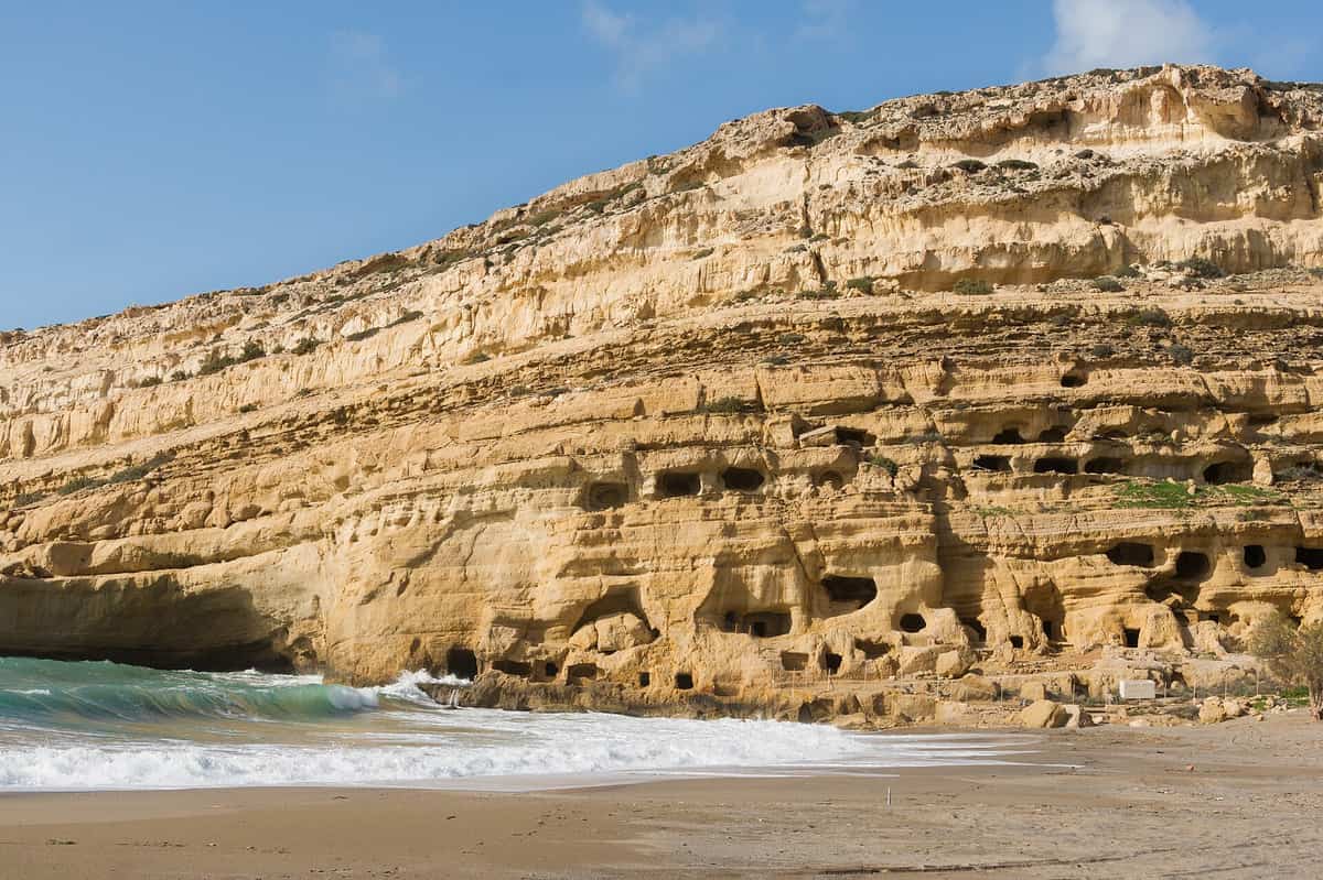
A Matala tour heads to the south coast of Crete, where a village and beach on the Libyan Sea sit below a cliff full of caves that served as tombs in antiquity. This post covers what a Matala tour includes, the caves, the hippie years, the beach, the ancient sites nearby, the history, a monastery and gorge in the area and the best season. It is one of the best tours in Greece on Greece VIP.
Each section ends with a Matala tour that can be booked online.
What does a Matala tour cover?
A Matala tour covers the village of Matala on the south coast of Crete, in the Heraklion regional unit. It takes in the bay, the beach on the Libyan Sea, the man-made caves in the cliff and the story of the hippies who lived there.
Matala, the village at the heart of a Matala tour, lies on the south coast of Crete, north of Cape Lithinon. Its Greek spelling is Μάταλα. In local government, it forms part of the community of Pitsidia. Pitsidia, in turn, sits within the municipal unit of Tympaki, inside the Faistos municipality. The bay and the beach carry the same name as the village.
Crete is the largest island of Greece. It spans 260 km from east to west but measures only 60 km at its widest point. Its coastline runs for 1,046 km. The Sea of Crete lies to the north of the island and the Libyan Sea to the south. Matala sits on the south coast, so a Matala tour looks out on the Libyan Sea rather than the Sea of Crete.
A Matala tour that starts in Heraklion crosses Crete from one coast to the other. Heraklion is the capital and largest city of the island, and it holds more than a fourth of its population. The city stands on the north shore. It has the biggest airport on Crete, Nikos Kazantzakis, along with ferry links to mainland Greece. Matala lies 75 km south-west of Heraklion, on the south coast.
Today Matala is a popular tourist destination. The village relies on coach tours and summer visitors, and it has a large number of gift shops and bars. Behind this modern face lies an older story, centred on the cliff of the bay. A Matala tour moves between the present village and that past. The caves, the legend of one of them and the hippie years all lead back to the same cliff.
- Village: Matala belongs to the community of Pitsidia in the Faistos municipality.
- Sea: The bay of Matala faces the Libyan Sea on the south side of Crete.
- Distance: The village lies 75 km south-west of Heraklion, the capital of Crete.
- Caves: Artificial caves from the Neolithic Age sit in the cliff of the bay, the main sight of a Matala tour.
- Hippie years: Hippies lived in the caves in the 1960s until the church and the military junta drove them out.
One village, one bay and one cliff give a Matala tour its full subject. The record spans Neolithic work in the cliff, a cave named after a Roman general, a hippie colony and the songs that Joni Mitchell drew from her stay in early 1970. All of it sits in the Faistos municipality, on the south coast of Crete.


Why are the caves the centre of a Matala tour?
A Matala tour centres on the caves because their story runs from the Neolithic Age, when people made them in the cliff of the bay, to the 1960s. One theory says they served as tombs, while their size points to living spaces.
The caves seen on a Matala tour are artificial. People created them in the cliff of the bay, so they are human work and not a product of nature. This sets them apart from the caves in the mountains of Crete, such as Gourgouthakas, Diktaion and Idaion. Myth names Idaion as the birthplace of Zeus. The Matala caves are of a different kind: human hands shaped them on the coast.
The caves date from the Neolithic Age, and that date gives a Matala tour its oldest layer. On Crete, the evidence for permanent settlement begins in the Neolithic, around 7,000 BCE. The early settlements kept cattle, sheep, goats, pigs and dogs, and they grew cereals and legumes. Knossos was one of the major Neolithic sites on the island. The Matala caves belong to this first age of settled life on Crete.
A Matala tour meets an open question at the cliff, namely how people used the caves. One suggestion holds that they once served as tombs. A second view rests on their volume. The rooms are larger than a burial requires, because the dead need no space to walk around. On that reading, the stronger case is that people lived in them. Both views start from the same fact: the caves are human work.
One cave has a name of its own: Brutospeliana. According to legend, the Roman general Brutus frequented this cave, and the name comes from him. The story gives a Matala tour a Roman thread inside a Neolithic site. Much later, the caves gained new residents. In the 1960s, hippies moved into them and made them their homes. With them, the cliff entered the modern history of Matala.
- Origin: The caves are artificial and date from the Neolithic Age.
- Setting: Permanent settlement on Crete begins in the Neolithic, around 7,000 BCE.
- Tomb theory: One suggestion holds that the caves once served as tombs.
- Living spaces: Their volume supports the view that people lived in them.
- Brutospeliana: Legend links this cave to the Roman general Brutus.
For these reasons, the caves form the core of a Matala tour. They are the work of Neolithic people, and their purpose is still debated between tombs and homes. A legend about a Roman general gave one cave its name. In the 1960s, the caves became homes for hippies. The cliff thus links ancient Matala with the Matala of the 1960s.
How did the hippies shape a Matala tour?
A Matala tour retells the story of the hippies who lived in the caves from the 1960s. Joni Mitchell stayed with them in early 1970, and her time there shaped the songs “Carey” and “California” on her 1971 album Blue.

Before the 1960s, Matala was a fishing village. In that decade, hippies moved into the caves in the cliff and formed a colony there. For a Matala tour, this decade marks the start of the modern story. Accounts describe the newcomers as a cave-dwelling community. Matala was not the only such place in Greece, since a hippie colony also existed at Paradise Beach on Mykonos.
Joni Mitchell reached Matala in early 1970, and her stay forms the core of this part of a Matala tour. Her relationship with Graham Nash had just ended, and she flew to Greece with a female friend for a break from fame. After days in Athens, the two travelled to Crete, rented a car and drove to Matala on the south coast. There Mitchell met Cary Raditz, a red-haired American with a cane, who worked as a cook at the Mermaid café.
Mitchell wrote the first version of “Carey” in Matala, for the 24th birthday of Raditz. After about two months, the pair travelled to Athens. Mitchell then flew alone to Paris, where she wrote “California” and called Raditz a “red, red rogue”. Back in the United States, she finished “Carey” with the other songs of Blue. The lyrics of “Carey” refer to Matala and to the open-air hippie life, so the song and a Matala tour share the same setting.
A Matala tour also covers how the cave years ended. The church and the military junta later drove the hippies out. The junta was a right-wing military regime that ruled Greece from 1967 to 1974, after a group of colonels overthrew a caretaker government on 21 April 1967. The expulsion closed the cave-dwelling era, yet the memory of it stayed in the village.
- Dulcimer: Mitchell taught herself the Appalachian dulcimer in Europe, and the instrument features on the original recording of “Carey”.
- Single: “Carey” entered the Billboard chart at number 93 on September 4, 1971.
- Cover versions: Goldie Hawn recorded the song in 1972, and Cyndi Lauper sang it at a televised tribute concert to Mitchell in 2000.
- Shepherd’s crook: Raditz later said that his cane was in fact a discarded shepherd’s crook.
The hippie story on a Matala tour does not end with the expulsion from the caves. The three-day Matala Beach Festival has celebrated that history every June since 2011. In 2023, at the Library of Congress Gershwin Prize concert for Mitchell, Marcus Mumford opened the show with “Carey”, and Raditz sat in the audience. Both events tie the song back to the village where it began.
What does the beach show on a Matala tour?
A Matala tour reaches a village bay 75 km south-west of Heraklion, where a cliff of artificial caves frames the beach. The shore runs north to Kommos Beach and south to Cape Lithinon, the southernmost point of Crete, on the Libyan Sea.
A Matala tour starts in a bay edged by a cliff with artificial caves. Matala was once a fishing village. Today it is a popular destination that relies on coach tours and summer visitors, and the village has gift shops and bars. Matala lies within Faistos municipality, which takes its name from the ancient city of Phaistos, also located inside its borders.
South of Matala, Cape Lithinon forms the southernmost point of Crete. The promontory rises to about 390 m at Mt. Kefali and drops steeply into the water on its southern side. It marks the southeastern limit of the Bay of Mesara and lies west of Kaloi Limenes. Along this stretch, the southern coastline of Crete borders the Libyan Sea. On a Matala tour, this headland ends the shore to the south.
A Matala tour can add Kommos Beach, 5 km north of the village and a popular swimming spot. The partly excavated Minoan harbour town sits beside it; the ruins are closed to the public but visible from the beach. When digging began in 1976, sand lay four metres deep over parts of the site. The Papadoplaka reef islet is thought to have partly sheltered the ancient town from waves and wind.
The same Bay of Mesara holds the Paximadia, two small uninhabited islands about 12 km south of Agia Galini. They sit so close that they look like one island from afar. Locals call them Elephantaki, after the shape of a baby elephant lying in the water with its trunk to the west. Myth names them as the birthplace of Artemis and Apollo, and their ancient name Letoai honours Leto, a goddess worshipped at Phaistos.
- Plain: Kommos stands on the coast of the Mesara Plain, the largest plain in Crete at about 50 km by 7 km.
- Shoreline: Since 1500 BC, a buildup of alluvial sediment has extended the plain by up to 6 km.
- Odyssey: In Book III of the Odyssey, storms push the ships of Menelaus onto the Gortyn coastline and against a sharp reef.
- Reef today: Rising sea levels and German bombing during the Nazi occupation have left the Papadoplaka reef largely submerged.
A Matala tour on this shore covers three fixed points: the cave-lined village bay, Kommos Beach 5 km to the north, and Cape Lithinon to the south. The Libyan Sea runs along the southern coast of Crete. Kommos gives a Matala tour a Minoan harbour beside the sand, while the Paximadia in the Bay of Mesara carry the myth of Leto and her children Artemis and Apollo.
Which ancient sites lie near a Matala tour?
A Matala tour has four ancient sites close by in the Mesara area: the Minoan palace of Phaistos, the Minoan town of Hagia Triada, the Minoan harbour of Kommos 5 km north of Matala, and Gortyn, the Roman capital of Creta et Cyrenaica.
Phaistos is a Bronze Age site in south central Crete, 62 km south of Heraklion and about 5.6 km east of the sea. It ranked with Knossos and Malia among the three largest cities of Minoan Crete. The first palace rose around 2000 BCE and was destroyed and rebuilt three times in about three centuries; the last fell around 1400 BCE. A Matala tour that stops here visits a UNESCO World Heritage Site.
On a Matala tour, Hagia Triada lies about 3 km from Phaistos, with which it appears to have had close political and economic ties. It was an upscale town with a local administration centre and a large Royal Villa. About 150 Linear A tablets came from here, the largest cache at any Minoan site. Its painted sarcophagus, unearthed in 1903, is the sole limestone example of its era and the only one showing Minoan funeral rites as a series of scenes.
Kommos served as the Minoan harbour town for Phaistos and Hagia Triada, and the three have been described as “a great Minoan triangle”. Its Building T rivalled the Phaistos palace in size, with a facade of the largest ashlar blocks the Minoans used. Kommos has yielded more imported pottery than any other Bronze Age site in the Aegean. For a Matala tour, it shows the working side of a Minoan port, from a ship shed to a pottery kiln.
A Matala tour that reaches Gortyn, 45 km from Heraklion in the Mesara valley, enters a site first settled around 7000 BC. The Praetorium, seat of the Roman governor of Crete, went up in the 1st century AD. Gortyn is known above all for the Gortyn Code, found in 1884, the oldest and fullest known code of ancient Greek law. Its laws are cut in the Dorian dialect on large stone slabs that remain plainly visible.
- Phaistos Disc: Excavators found the disc in 1908 in Room 101, a basement on the north side of the palace.
- First survey: In 1853 Thomas Spratt located Phaistos by triangulating from Gortyn, Matala and the coast.
- Ship shed: Building P at Kommos, with six long galleries open toward the sea, is read as an early ship shed.
- Cathedral: The cathedral of St. Titus, first Bishop of Crete, was built at Gortyn in the 6th century AD.
A Matala tour can link all four sites across the Mesara: the palace at Phaistos, the villa town of Hagia Triada, the harbour of Kommos and the Roman city of Gortyn. Together they span Minoan palaces, Bronze Age sea trade and Roman rule. The Phaistos Disc, the largest cache of Linear A tablets and the Gortyn Code all come from this plain, within reach of a Matala tour.
What is the history behind a Matala tour?
A Matala tour follows a port history from Minoan Phaistos to Roman Gortyn. Matala served Phaistos in the Minoan period, fell to the Gortynians in 220 BC and became the port of Gortyn under Rome, and myth places Europa’s arrival on its beach.
The harbour story of a Matala tour begins with Phaistos, whose port Matala was in the Minoan period. In 220 BC the Gortynians occupied the village, and after the destruction of Phaistos, Gortyn extended its power to it. Under Roman rule Matala served as the port of Gortyn, a city also known as Gortys or Gortyna. In the Hellenistic era Gortyn had become the strongest city of Crete and held hegemony over the island.
Ancient Crete also had a town called Matalia, near the headland of Matala, and its site lies near the modern village. It is thought to be the same place that Strabo called Metallum or Metallon, the port and naval arsenal of Gortyna. Gortyn allied with Rome and became the capital of the joint province of Creta et Cyrenaica. A Matala tour thus stands at the port of a Roman provincial capital.
Zeus desired Europa, a Phoenician princess, so he turned into a tame white bull and mixed with her father’s herds. When she climbed onto his back, he ran to the sea and swam with her to Crete. One version lands them on the beach of Matala, where Zeus changed into an eagle and flew her to Gortyn. The beach on a Matala tour is the landing place in this telling.
Europa became the first queen of Crete. Gortyn’s tradition places her union with Zeus under a plane tree, and a Matala tour that continues to Gortyn can still see that tree. Their three sons, Minos, Rhadamanthys and Sarpedon, became kings of the three Minoan palaces of Crete. Zeus also gave Europa a necklace made by Hephaestus, the bronze guard Talos, the hound Laelaps and a javelin that never missed.
- Statue: A colossal statue of Europa on a bull, found at Gortyn in the nineteenth century, is now in the British Museum.
- Taurus: Zeus later set the shape of the white bull among the stars as the constellation Taurus.
- Saint Paul: The Acts of the Apostles has Paul land at Kaloi Limenes, east of Cape Lithinon, on his way to Rome as a prisoner.
- Arab landing: Cape Lithinon is one proposed site of Cape Charax, near which Arab pirates landed in the 820s to start their conquest of Crete.
A Matala tour joins two threads of this history on one shore. The beach is where one version of the myth lands Europa before her flight to Gortyn, and the bay is where Minoan Phaistos and then Roman Gortyn kept their port. A Matala tour that adds Gortyn after the beach follows both threads, from the landing place to the plane tree and the old provincial capital.
Which monastery and gorge does a Matala tour pass?
A Matala tour that climbs into the Asterousia Mountains reaches the Odigitria Monastery, which stands near a Minoan site with two tholos tombs. The same range separates the Messara Plain from the Libyan Sea and holds gorges, such as the Ambas Gorge.
South of the Messara Plain, the ground rises into the Asterousia Mountains. The Messara is an alluvial plain about 50 km long from west to east and 7 km wide from north to south, the largest plain in Crete. Olive trees, vineyards and horticultural crops grow on its fields, and the Messara horse is native to it. A Matala tour bound for the monastery leaves this farmland and climbs toward the range that walls the plain off from the Libyan Sea.
The Odigitria Monastery stands in the Asterousia Mountains of southern Crete, and a Matala tour that heads up to it also reaches a far older layer of history. Close to the monastery lies Odigitria, the archaeological site of an ancient Minoan religious complex with two tholos tombs. The tombs date from Early Minoan I to Middle Minoan IA and stayed in use for more than 1,000 years. N. Dimopoulou excavated them in 1979, and Antonis Vasilakis dug there in 1980.
Finds from the two tombs include seals, amulets, necklaces, gold diadems, stone blades, stone vases, pots and a gold bracelet. The mountains around the site also carry the name Kofinos Range, after their highest peak, Kofinas, at 1,231 m. The village of Kapetaniana sits on the southern slope. To the north lies Phaistos, whose palace appears to have been planned with views over the Messara Plain and the Asterousia, so a Matala tour sees the ridge from the plain as well as from the hills.
The Asterousia range that a Matala tour enters also holds gorges. The Ambas Gorge lies about 50 km south of Heraklion in these mountains, carved by the Mousoulis stream. Its main waterfall drops 145 m, one of the highest vertical falls in Greece, and smaller falls continue below it toward the sea. Reaching the foot of the main drop needs technical climbing gear. The name Ambas comes from the Latin word abbas, meaning abbot, and hermit monks once lived secluded in the Asterousia.
- Monastery: A Matala tour into the hills reaches the Odigitria Monastery in the Asterousia Mountains.
- Minoan tombs: Two tholos tombs near the monastery date from Early Minoan I to Middle Minoan IA.
- Range: The Asterousia Mountains reach 1,231 m and separate the Messara Plain from the Libyan Sea.
- Gorge: The Ambas Gorge in the same range has a main waterfall 145 m high.
- Clay: A significant share of Minoan pottery was made from Messara clay.
A Matala tour into the Asterousia adds a mountain stage to a day on the coast. The tombs beside the monastery stayed in use for more than 1,000 years, and the Ambas Gorge shows how a stream cuts down through the range toward the sea. The cliffs of the wider Asterousia region hold the largest island-based population of birds of prey in Europe, and Cretan gorges shelter the endangered lammergeier vulture.
When is the best season for a Matala tour?
A Matala tour suits every season of the year: the village has a hot-summer Mediterranean climate, with hot, very dry summers and very mild, wet winters. The south coast of Crete also gets more sunny days and higher average temperatures all year.
Matala has a hot-summer Mediterranean climate, class Csa in the Köppen system. Summers in the village are hot and very dry, and winters are very mild and wet. Tympaki, a town on the south coast between Agia Galini and Matala, shares the same Csa class, with hot, dry summers and mild, rainy winters. For a Matala tour, this means the rain falls in the cool half of the year, while the warm months stay dry.
Crete as a whole sits across two climate zones, the Mediterranean and the semi-arid, and falls mainly in the first. Its main climate is hot-summer Mediterranean, but parts of the south and east have a hot semi-arid climate, class BSh. Higher ground falls into the cold-summer Mediterranean class, Csc. Snow is common on the mountains between November and April but rare in the majority of low-lying areas, so a Matala tour on the coast in winter meets mild weather.
A Matala tour stays on the sunny side of Crete. The south coast, including the Messara Plain and the Asterousia Mountains, gets significantly more sunny days and higher average temperatures through the year. Date palms bear fruit there, and swallows stay all year instead of only in summer. The Hellenic National Meteorological Service puts South Crete first in Greece for sunshine, with more than 3,257 hours a year. Average annual temperatures reach up to 22.0 °C at Tris Ekklisies and Psari Forada in South Crete.
The sea seen on a Matala tour is the Libyan Sea, the part of the Mediterranean that stretches south from Crete toward the African coast. The name is older than the modern state of Libya and comes from the ancient name Libya, which covered much of North Africa west of the Nile. The stretch south of Crete has recently also started to carry the name South Cretan Sea. Apart from Crete, its islands are Gavdos, Gavdopoula, Koufonisi and Chrysi.
- Climate class: Matala falls in the hot-summer Mediterranean class, Csa.
- Summer: A Matala tour in summer meets hot, very dry weather.
- Winter: Winters on the coast are very mild and wet, while snowfall is common on the mountains between November and April.
- Sunshine: South Crete records more than 3,257 hours of sunshine a year.
- Southern edge: Gavdos, 48 km south of Hora Sfakion in the Libyan Sea, is the southernmost point of Europe.
The weather on a Matala tour follows two seasons: hot, very dry summers and very mild, wet winters. Crete also holds the records for the highest temperatures measured in Europe in October, November, January and February among W.M.O. stations. In June, the village hosts the three-day Matala Beach Festival, a fixture each year since 2011.
What do travelers ask about a Matala tour?
A Matala tour raises four practical questions: which regional unit the village belongs to, how far it lies from Heraklion, which gulf its bay opens onto, and whether Knossos fits on another day. The short answers are Heraklion, 75 km, Messara and yes.
Which regional unit does a Matala tour visit?
The village at the end of a Matala tour lies in the Heraklion regional unit, one of the four regional units of Crete. Matala is part of the community of Pitsidia, within the municipal unit of Tympaki in the Faistos municipality. Faistos takes its name from ancient Phaistos and was formed in 2011 from Moires, Tympaki and Zaros.
How far from Heraklion does a Matala tour go?
Matala lies 75 km south-west of Heraklion. The EO97 road runs from the city of Heraklion to Agia Galini, and Tympaki lies on the south coast between Agia Galini and Matala. A European Union study has proposed a 15.7 km road section between Agia Varvara and Agia Deka, on the route between the Messara and Heraklion.
Which gulf does a Matala tour look out over?
A Matala tour looks out over the Gulf of Messara, also called the Bay of Messara, in southern Crete. Matala lies north of Cape Lithinon, the southernmost point of the island, which marks the southeastern limit of the bay and rises to about 390 m. Loggerhead turtles nest and hatch on south-coast beaches along this gulf.
Can a Matala tour pair with a visit to Knossos on another day?
Yes. A Matala tour covers the south coast, while Knossos lies within the southern edge of Heraklion, about 5 km south of the historic centre, so the palace fits a separate day. Knossos grew into the largest and best-known Minoan centre. Travelers who plan that second day can arrange Knossos tickets in advance.