
A Corfu boat trip follows the coast of Corfu, the northernmost of the main Ionian Islands, from the green bays and sea caves of the north-west to the old town and the small islets by the harbour. This post covers what a Corfu boat trip includes, the ports, Paleokastritsa, Corfu town from the sea, Mouse Island, the north coast, the islands within reach and the best season. It is one of the best tours in Greece on Greece VIP.
Each section ends with a Corfu boat trip that can be booked online.
What does a Corfu boat trip include?
A Corfu boat trip is a sea outing along the coast of Corfu, an island in the Ionian Sea with a long shoreline of capes, bays and small islands. Routes run around the coast, to the north west bays, or south to Paxos.
Corfu lies in the north western corner of Greece and is the northernmost island on the west coast, apart from the Diapontian Islands. Its north eastern edge faces Sarandë in Albania across a strait that narrows to 3 km and widens to 23 km. Corfu and the Diapontian Islands mark the border between the Ionian Sea and the Adriatic Sea, so a Corfu boat trip follows a shore where two seas meet.
The ancients compared the shape of the island to a sickle, and the coastline runs for 217 km including the capes. Corfu Bay stretches across much of the eastern shore, where the small islands of Lazareto and Ptychia lie between Gouvia and the bay. Beaches line the shore at Kassiopi, Sidari and Palaiokastritsa. A Corfu boat trip has plenty of coast to choose from.
Corfu is the first of the seven principal Ionian Islands when they are listed from north to south, and Paxos is the second. The regional unit of Corfu reaches as far south as the Paxoi. The group is traditionally called the Heptanese, meaning Seven Islands, and its six northern members lie off the west coast of Greece. The seventh, Kythira, lies off the Peloponnese.
- Coastal circuit: A Corfu boat trip around the shore passes the capes, the bays and the small islands off Corfu Bay.
- North west bays: This route heads for the cliffs and beaches around Palaiokastritsa.
- Paxos route: This crossing runs south to the next island of the Ionian chain.
The three routes share one sea and one island. The circuit shows how Corfu is shaped, the north west route shows its cliffs and beaches, and the Paxos route shows where the island group continues. Every Corfu boat trip starts from a port, and the port decides which stretch of water comes first.


Which ports does a Corfu boat trip leave from?
A Corfu boat trip leaves from the port of Corfu town, from Paleokastritsa on the west coast, from Kassiopi in the north east, from Benitses south of the town, from Lefkimmi in the south and from Sidari in the north.
Corfu town is the capital of the Corfu regional unit and of the Ionian Islands region. Its old town joined the UNESCO World Heritage List in 2007. The Venetian citadel ends the peninsula on which the town stands, and a salt-water ditch beside it works as a small marina called Contra-Fossa. A Corfu boat trip from this port starts beside the fortified capital of the island.
Paleokastritsa is a village on the west coast, just south of Angelokastro, and its name means Old Little Castle. Kassiopi is a fishing village on the north eastern coast with a history that reaches back to ancient Greece. Kassiopi Castle stands above it, and the village looks over the Corfu Channel. A Corfu boat trip from either one sees a different coast.
Benitses is a fishing village 12 km south of Corfu town, set between the sea and the hills. Lefkimmi is the southernmost municipal unit on the island and its second largest settlement, with a canal through the eastern part of the town. Sidari is a resort village in the northern part of the island and the site of an ancient monastery.
- Corfu town: Ferries from the city port reach Gaios on Paxos and Patras.
- Kassiopi: A Corfu boat trip starts in the harbour, where motor boats are hired.
- Lefkimmi: The small port at the southern tip runs a ferry to the mainland.
- Benitses: The sheltered bay has calm, clear water that suits boating and snorkelling.
Six ports give a Corfu boat trip six different starting points: the capital, the cliffs of the west, the channel in the north east, the bay at Benitses, the canal town in the south and the resort village in the north. Each start gives a first view. The next section follows the west coast to Paleokastritsa.
What does a Corfu boat trip see at Paleokastritsa?
A Corfu boat trip at Paleokastritsa sees the great cliffs and nearby beaches around the bay, the monastery that dates from 1225, and Angelokastro, a Byzantine castle on the highest peak of the north west shoreline, 305 m above the sea.
The bay of Palaiokastritsa lies on the north western coast of Corfu. Corfu has been suggested as the island of the Phaeacians, and the bay as the place where Odysseus came ashore and met Nausicaa. A Corfu boat trip here sees a village known for its cliffs and nearby beaches. The name of the village means Old Little Castle, a reference to Angelokastro above it.
The monastery of Paleokastritsa dates from 1225 and houses a museum. Angelokastro stands on the highest peak of the shoreline, on a steep cliff above the sea, and it looks across to the city of Corfu and the mountains of the mainland. Angelokastro ranks as one of the major fortified complexes of Corfu. A Corfu boat trip sees the same cliffs that protected the castle for centuries.
The castle never fell, despite frequent sieges, and it helped to defeat three Ottoman sieges of Corfu. It formed a defensive triangle with the castles of Gardiki and Kassiopi. Its garrison signalled the approach of any enemy to the city. The main gate of the castle faces north, and a circular tower protects it. During invasions, the castle sheltered the peasants of the area.
- Church of the acropolis: The church at the highest point is dedicated to Archangel Michael.
- Cisterns: Three underground cisterns supplied the castle with water.
- Chapel of St. Kyriaki: A tiny cave-like chapel on the east side was dug into the rock.
Paleokastritsa joins myth, a monastery and a fortress along one stretch of the north west coast. A Corfu boat trip to this coast shows the cliffs from below, while the castle looks down on the sea from the peak above. The same shoreline continues north towards Sidari and the Diapontian Islands.
What does a Corfu boat trip see of Corfu town from the sea?
A Corfu boat trip sees Corfu town as a Venetian fortress city on a peninsula. The Old Fortress covers the promontory, the New Fortress stands on the hill of St. Mark, and the Old Town below them is a World Heritage site.
The Old Fortress stands out from the water. It covers the promontory between the Gulf of Kerkyra to the north and Garitsa Bay to the south. The Venetians cut it off from the city with a moat and made it an artificial island. Its twin peaks gave the town its Western name, Corfu, from the Greek word Coryphe. A Corfu boat trip passes below them.
The fortress held firm in all three major Ottoman sieges, in 1537, 1571 and 1716. The engineers Savorgnan and Martinengo designed its bastions between 1545 and 1555, and they are considered masterpieces of military engineering. In 1718 lightning struck the powder magazine, and the explosion wrecked the palace of the Captain General. A Corfu boat trip passes the east side, where the wall is slowly eroding into the sea.
The New Fortress rises on the hill of St. Mark. The Venetians built it after the first great Ottoman siege and razed 2,000 homes in the suburb of San Rocco to clear space for its walls. Its bastion stands 55 m above sea level, with a view across the sea to the mountains of mainland Greece. The buildings inside date from British rule, from 1815 to 1863.
- Old Fortress: A Venetian citadel on an artificial island, reached by a permanent bridge.
- New Fortress: A hilltop fortress with British barracks below its bastion.
- Liston: The esplanade between town and citadel, named for a Venetian word meaning evening promenade.
The old town of Corfu joined the UNESCO World Heritage List in 2007. ICOMOS experts noted that its layout and structure, including the Venetian fortifications, make Corfu a quintessential example of a fortified maritime city. They noted that about 70% of the pre-20th century buildings date from the British period. A Corfu boat trip shows that outline whole.
What is Mouse Island on a Corfu boat trip?
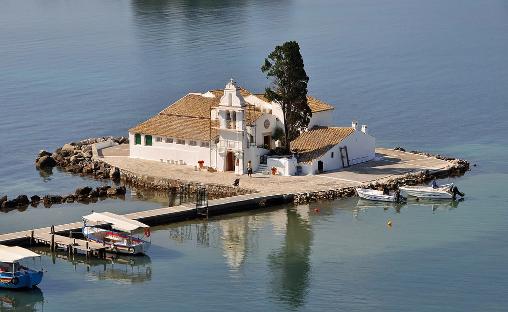
A Corfu boat trip meets Mouse Island, Pontikonisi in Greek, as a small, very green islet near Corfu. Its Byzantine chapel of Christ Pantokrator dates from the 11th or 12th century. Landing aircraft give passengers a view of both the island and the Vlacherna Monastery.
The Greek name Pontikonisi means Mouse Island. The islet is small and very green, with abundant trees, and its highest natural point stands at about 2 m. The white stone staircase of the monastery on it resembles a mouse tail when viewed from afar, and that tail gave the island its name. A Corfu boat trip sees the staircase from the water.
The chapel is the main feature of the islet. It is Byzantine, dedicated to Christ Pantokrator, and dates from the 11th or 12th century. The painting Isle of the Dead by Arnold Böcklin is linked to the islet as a possible inspiration. The conservationist Gerald Durrell lived on Corfu as a child and used to swim out to it, and a portion of his ashes was scattered there.
The islet lies half a kilometre south of the international airport. The runway used for landing in a northeasterly direction sits close to the island. Passengers on arriving flights see Pontikonisi and the Vlacherna Monastery from the air, with the hills of Kanoni in the same view. On a Corfu boat trip, landing aircraft pass close to the same landmarks.
- Pontikonisi: A Greek islet near Corfu whose name means Mouse Island.
- Chapel: A Byzantine chapel of Christ Pantokrator from the 11th or 12th century.
- Vlacherna Monastery: A landmark seen from landing flights alongside the island.
Legends gather around the island and its waters. In myth, Poseidon fell in love with the nymph Korkyra and gave the island her name, and Corfu is known as the island of the Phaeacians. The 1981 film For Your Eyes Only shows Melina greeted by James Bond at Pontikonisi. A Corfu boat trip passing the islet meets myth and film in one view.
What does a Corfu boat trip see on the north coast?
A Corfu boat trip on the north coast sees the resort village of Sidari, the castle ruins above the fishing village of Kassiopi on the northeast coast, and, to the north-west, the small Diapontia islands, the westernmost point in Greece.
Sidari is a resort village in the northern part of Corfu. It belongs to the municipal unit of Esperies and is the site of an ancient monastery. The list of beaches on the island names Sidari and Kassiopi. The island is made of limestone formations, which give the coast a great diversity of surface. A Corfu boat trip sees that variety from the sea.
Kassiopi is a fishing village of Ancient Greek origin on the northeast coast. It overlooks the Corfu Channel, the strait that separates the island from the mainland. The fortifications of Kassiopi Castle are mainly Byzantine, the Venetians strengthened them, and they survived Ottoman sieges in the 16th century. The ruins stand above the village. Cicero describes sheltering in its harbour.
The Diapontia Islands, also called the Othoni Islands, lie north-west of Corfu in the Ionian Sea. The group has 12 islands and islets, and only Othoni, Ereikoussa and Mathraki are inhabited. Othoni is the largest, at 10.8 km2, and an active lighthouse from the 19th century stands at Akro Kastri. They are the farthest land to the north-west that a Corfu boat trip can show.
- Sidari: A resort village on the northern shore, site of an ancient monastery.
- Kassiopi Castle: A ruin entered along a narrow walkway between homes.
- Diapontia Islands: Twelve islands and islets, three of them inhabited.
Kassiopi has a church with a long record. The temple of Cassius Zeus became a Christian church in the 5th century, the Turks burned it in 1537, and it was restored between 1590 and 1591. On Othoni, a white stone cross at Stavros marks the same year, when the Turkish fleet massacred the inhabitants. A Corfu boat trip along the north passes places that 1537 shaped.
Which islands and coasts lie within reach of a Corfu boat trip?
A Corfu boat trip reaches three kinds of destination: Paxos and Antipaxos, the small islands to the south, the mainland coast of Epirus with the resort town of Parga, and the shore of Albania across the channel, where the city of Saranda faces northeastern Corfu.
A Corfu boat trip that sails south meets Paxos first, the island that lies just south of Corfu in the Ionian Sea. Myth credits Poseidon with its making: he is said to have struck Corfu with his trident, to find peace and quiet with his wife Amphitrite. Paxos covers 25.3 square kilometres, and its highest point stands at 231 metres. Antipaxos lies about 3 kilometres south and held 21 residents in 2021.
The mainland coast of Epirus forms the second destination. Parga stands on the Ionian shore between Preveza and Igoumenitsa, and in summer boats bring tourists there from Corfu, Paxos and Antipaxos. The link goes back to Venetian times: in 1401 Parga came under Venice and was run as a mainland exclave of Corfu, under a castellan. The Venetians rebuilt its hilltop castle for the third and last time in 1572.
Albania forms the third coast. The northeastern edge of Corfu lies off Sarandë, and the straits between the two shores vary in width from 3 to 23 kilometres. Sarandë was the ancient port of Onchesmos, and near it lie the remains of Butrint, a UNESCO World Heritage site. Flying Dolphin ferries already link Corfu with Sarandë, so a Corfu boat trip on this side crosses a channel that regular boats serve.
- Paxos: An island of 25.3 square kilometres with olive groves on its hills.
- Epirus: Parga has Valtos Beach beside its castle.
- Albania: Sarandë is the unofficial capital of the Albanian Riviera, with over 300 sunny days a year.
Distance sets the order of these coasts. Paxos lies 15 kilometres from the southern tip of Corfu and at about the same distance from Parga. The Albanian shore begins at the northeastern edge of Corfu. Each direction gives a Corfu boat trip a different shore. Travelers who want the two southern islands in full can read about a Paxos Antipaxos cruise.
When is the best season for a Corfu boat trip?
A Corfu boat trip suits the dry summer best, because Corfu has a hot-summer Mediterranean climate: hot, dry summers and mild to cool, very rainy winters. The winters are much wetter than on other Greek islands, and the wet winter marks the quieter months.
Corfu has a hot-summer Mediterranean climate, classed as Csa in the Köppen system. Summers are hot and dry, while winters are mild to cool and very rainy. The island’s winters are much wetter than winters on other Greek islands. The year therefore splits into a dry season and a wet season, and a Corfu boat trip fits the dry season best.
The climate of Greece adds detail for the Ionian Islands. Summer weather there is frequently sunny and dry, and any rain falls as showers or thunderstorms. Heatwaves occur, yet at the coast they stay milder, because the cooler sea and the sea breeze moderate the temperature. On a Corfu boat trip, the sea is a cooling force as well as a route.
The Etesian winds, called meltemia, blow in the warm months, with the highest frequency in July and August. They keep temperatures in the Aegean Sea lower than those in the Ionian Sea, so the Ionian side stays warmer. The part of Greece west of the Pindus mountains is also wetter and has maritime features, and the western areas of the Mediterranean zone receive more of the persistent winter rain.
- Summer: Hot and dry, with the sea breeze softening the heat along the coast.
- Winter: Mild to cool and very rainy, and wetter than on other Greek islands.
- Parga: The mainland town records about 1219 mm of rain a year, mainly in winter.
The dry summer carries the strongest case for a Corfu boat trip, since the weather is sunny and dry and the sea cools the coast. Sea services also follow the seasons. Outside the tourist season, a hydrofoil passenger service still runs to Paxos, but it is infrequent and depends on the weather, while ferries from Igoumenitsa operate all year.
What do travelers ask about a Corfu boat trip?
A Corfu boat trip prompts questions about reaching the island, its size, its name and a second trip on Kefalonia. Corfu, one of the Ionian Islands, covers 592.9 square kilometres and has an international airport and ferry links to Paxos, Igoumenitsa, Sarandë and Patras.
How is Corfu reached by air and ferry before a Corfu boat trip?
Ioannis Kapodistrias International Airport lies around three kilometres south of Kerkyra, the island’s capital. By sea, traditional ferries run to Gaios on Paxos and as far as Patras, while high-speed Flying Dolphin ferries link Corfu with Igoumenitsa and Sarandë. The small port of Lefkimmi, at the southern tip, offers a ferry service to the mainland.
How large is the island behind a Corfu boat trip?
Corfu covers an estimated 592.9 square kilometres, runs about 64 kilometres long and reaches a greatest breadth of around 32 kilometres. Its coastline spans 217 kilometres including capes, and its highest point is Mount Pantokrator at 906 metres. The ancients compared the shape of the island to a sickle.
What does the name of the island mean for a Corfu boat trip?
The Greek name Kerkyra comes from myth: Poseidon fell in love with the nymph Korkyra, brought her to the unnamed island and gave it her name. The form Corfu is the Venetian and Italian version of the Byzantine Greek Koryphō, meaning city of the peaks, after the two peaks of Palaio Frourio.
Can a Corfu boat trip pair with a Kefalonia boat tour on another Ionian island?
Both islands belong to the Ionian group, so the two trips fit one wider journey. Kefalonia is the largest of the Ionian Islands and the sixth-largest island in Greece, and a Greek seaplane operator offers scheduled flights from Corfu to Kefalonia. A Kefalonia boat tour then covers the coast of that island.
Featured photo: George C. Tsiagalakis, CC BY-SA 4.0, via Wikimedia Commons.