
Milos snorkeling means swimming face down with a mask and snorkel over the clear, rocky seabed of Milos. Coves, sea caves and volcanic rocks lie close to shore. It is one of the snorkel trips in Greece on Greece VIP.
This post covers what Milos snorkeling includes, the best beaches and the sea caves. It also covers sea life, the volcanic vents and safety. Polyaigos and Kimolos, the old mining remains and the boat trips that add snorkeling follow. Underwater photos, the best season and common questions come last.
Each section ends with a Milos snorkeling trip or a nearby sea tour that can be booked online.
What does Milos snorkeling include?
Milos snorkeling includes rocky islets, shoals, reefs and wide fields of seagrass. The Aegean Islands portal ranks these seabeds among the finest in the Aegean. The water is full of fish and colourful plants. Hot springs on the seabed host their own small sea communities.
Snorkeling here covers a long protected coast. The Natura site for western Milos covers 5328.25 ha, and only 8.35 ha is land. The zone runs from Adamas port to the far west. Its edge measures 128.7 km.
Cymodocea seagrass grows along the north coast of western Milos. Posidonia, another sea grass, covers the whole sea part of the zone. In the west, ships loading minerals from the quarry can make the water cloudy in spots.
Gear is easy to find on the island. Diving centres rent out equipment and boats. They also give lessons to beginners. Snorkelers can also join sea kayak tours of Milos.
- Arkoudes: The Aegean Islands portal names this rocky islet as worth a swim.
- Antimilos: Shallow reefs and Cymodocea beds lie near this small island.
- Deep water: The sea between Antimilos and Milos can be more than 200 m deep.
- Monk seals: In 1999, 25-40 seals of mixed ages lived around Milos, Antimilos, Kimolos and Polyaigos.
Fishing puts pressure on fish life in local waters. Angling and professional fishing affect the fish stock in western Milos to a degree. Hippocrates, the ancient Greek doctor, wrote about the island’s hot springs.


Which beaches suit Milos snorkeling?
Milos snorkeling works well at Papafragas, Firiplaka, Tsigrado, Paleochori, Agia Kyriaki and Provatas. The north coast adds Fyropotamos and Mandrakia. Each beach has its own rocks, sand and depth. Steps or paths lead down to the wilder coves.
Steps carved in the rock lead down to Papafragas, a closed bay with emerald water. Pirates used the cove as a base in Byzantine times. Firiplaka has huge rocks in white, yellow, orange, red and grey.
Tsigrado sits between rocks, with white sand and emerald water. A steep, sandy path leads down the hill to it. Paleochori lies 8 km from Adamas port. It is 700 m long and faces south.
Paleochori is a strong snorkeling beach. Its shore and seabed are rocky, and the 5 m depth line sits about 160 m out. Sulphur and iron oxides colour its rocks. Hot springs here reach 65 degrees Celsius.
- Agia Kyriaki: Its sandy floor has small white pebbles, and the sand reaches 102 degrees Celsius in spots.
- Provatas: Golden-red sand and very shallow water suit children here.
- Shelter: These southern beaches stay calm except in medium and strong south-west winds.
- Fyropotamos: This beach lies 2.5 km north of Triovasalos, under white cliffs.
The north coast gives snorkeling a village feel. Fyropotamos and Mandrakia have syrmata, old boathouses cut into the rock. Mandrakia is a quiet beach almost 150 meters long. It grows around the church of Zoodochos Pigi.
Which sea caves suit Milos snorkeling?
Milos snorkeling leads to sea caves at Papafragas, Sarakiniko, Agios Konstantinos and Tsigrado. Waves and wind shaped them from volcanic rock. Pirates and rebels once hid inside. Underwater caves in the west also give monk seals a place to rest.
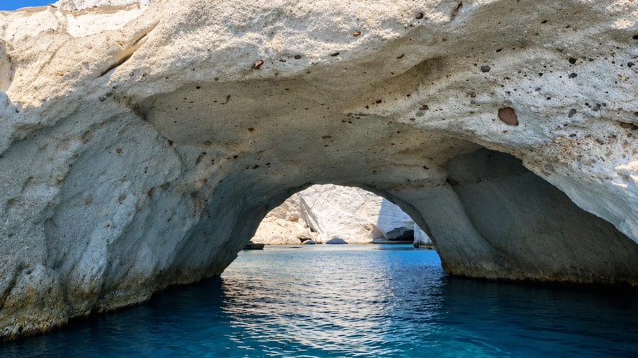
The three caves of Papafragas follow one after another, with walls that rise straight up. The Aegean Islands portal ranks them among the finest of their type in Greece. Like Kleftiko, they were hideouts during the Turkish occupation.
Sarakiniko suits snorkelers who like geology. Its white rock began forming under the sea 1.85 million years ago and slowly rose. The layer is about 50 metres thick. Saracen pirates sheltered in its sea caves.
Agios Konstantinos has a beach closed in like a lake. Two small caves wait there to be explored. Nearby, a small cape called Kofto has broken away into its own islet.
- Tsigrado caves: The Aegean Islands portal says Tsigrado has small caves to explore.
- Noches: Sea air wears hollows into hard rock, and a number look like open-mouthed animal heads.
Milos snorkeling near caves calls for care. In western Milos, one underwater cave serves monk seal mothers while they raise their pups. Swimmers keep a calm distance from these quiet places.
Which sea life does Milos snorkeling show?
Milos snorkeling shows blennies, invasive fish, bright anemones, snails and seagrass in shallow water. Small fish guard rocky cracks near the shore. Newcomers from the Red Sea now swim here too. Seagrass meadows grow on calm, sheltered sandy spots.
The tompot blenny lives at depths of 3 to 32 m. It guards a territory around a crevice in the rock. It grows up to 30 cm. A branched tentacle sits over each eye.
The black-faced blenny is a triplefin, a fish with three dorsal fins. It hides under large rocks and overhangs at 3 to 40 m. Breeding males turn yellow with a black head.
Milos snorkeling also reveals fish from the Red Sea. The common lionfish came through the Suez Canal. It was first recorded off Israel in 1991. By day it hides in crevices.
Seagrass covers sheltered sand. Cymodocea nodosa has seven to nine veins on each leaf. Halophila stipulacea, a seagrass from the Indian Ocean, can push out native species with thick mats.
- Cornetfish: This long fish grows to 1.6 m and hovers in small schools.
- Beadlet anemone: It shows up to 192 tentacles with bright blue beads below them.
- Thorny oyster: This shellfish cements itself to rocks and lives up to 18 years.
The banded dye-murex is a sea snail of shallow water. Minoans and classical Greeks made a purple-blue dye from it. Cushion coral is endangered after heat wave die-offs.
How do the volcanic vents shape Milos snorkeling?
Milos snorkeling happens above one of the largest shallow-sea hydrothermal systems described so far. Hot water and gas rise from the seabed. Colourful mineral crusts and white bacterial mats cover the sand. Seagrass still grows close to the hot spots.
The system covers about 35 km². The strongest known venting lies in Paleochori Bay, on the south-east coast. Its vents range from 3 m to at least 300 m deep.
The vent fluids are acidic, around pH 4.4, and reach up to 122°C. Their gas is mostly carbon dioxide, commonly over 90%. Smaller amounts of hydrogen, hydrogen sulfide and methane mix in.
Where vent fluid meets seawater, minerals settle on the sand. They show white, yellow, orange and brown colours. Across a single sand ripple, the mats shift from white to yellow to brown.
Sunlight reaches these shallow vents, so life uses both light and chemosynthesis, energy taken from chemicals. Milos snorkeling near Saganaki, at 12 m depth, shows a white microbial mat about 1 cm thick.
- Ochre patches: Brown sand gets its colour from iron and manganese oxides.
- White patches: A thin white dust covers sand, mainly in the eastern bay.
- Storm effect: A storm erased the white mat, but thin layers returned a day later.
Seagrass only 2 m from Saganaki stays close to normal warmth. Its sediment rises just from 19 to 21°C in the top 20 cm.
How safe is Milos snorkeling?
Milos snorkeling stays safe with calm habits and respect for the seabed. Hot sand patches mark gas vents in Paleochori Bay. Strong sun, lionfish spines and falling rocks need care too. Snorkelers always keep their hands off the bottom.
Black sand patches mark intense gas venting. They reach 90°C at 10 cm depth. One vent at only 10 m depth has recorded up to 119°C.
Hydrogen sulfide, a harmful gas, makes up as much as 8.1% of vent gas here. It is slightly denser than air. At 10–20 ppm it starts to irritate the eyes.
Humans hear less well underwater. They also struggle to tell where a sound comes from. So snorkelers stop, lift their heads and look around before swimming on.
A lionfish sting is rarely fatal. Yet it can cause extreme pain, vomiting and breathing difficulties. Emergency medical care is strongly recommended after a sting. So snorkelers look but never touch.
- UV level 3+: WHO advises protection once the UV index reaches 3.
- UV level 8+: A shirt, sunscreen and hat are a must, away from midday sun.
- Peak hours: The UV peak comes in the four hours around solar noon.
One falling rock can knock others loose on its way down. Weathering, water and roots wedging into cracks trigger rockfall. Snorkelers keep away from scree, the piles of fallen rock at cliff feet.
Can Milos snorkeling reach Polyaigos and Kimolos?
Milos snorkeling can reach Polyaigos and Kimolos by sea. Both islands sit in one protected Natura 2000 site. Its code is GR4220006, and it covers 13,897.73 hectares. Between the two islands, the sea is in large part less than 30 m deep.
Only 3,433.73 hectares of the site are land. The rest is open sea. The protected zone reaches 1 nautical mile out from the coast. That strip is about 65% of the site.
Posidonia seagrass grows thick in the shallow coastal zone. Milos snorkeling finds fish sheltering in these meadows. Rare sea urchins, corals, lobsters and fan mussels live on the seabed. Sea turtles swim in Kimolos waters too.
Polyaigos also goes by the names Ypolyvos and Polyvos. Its beaches are Panagia, Pano Mersini, Kato Mersini and Ammoura. The islet of Manolonisi lies to the west. The Kalogeroi islets lie off the south coast.
Signs suggest people lived there in the Mesolithic or Neolithic age. Kimolos and Milos took their quarrel over it to court in 416 BC. In 338 BC, Argos judges gave it to Kimolos. Today boat trips around Milos cross that old border.
- Lighthouse: It has stood on Cape Maskoula since 1898, at 138 m.
- Goats: 1,500 to 2,000 free-grazing goats are the only human pressure.
- Rema: This natural rock pool near Chorio sits beside the Rematonisa islets.
Intensive and illegal fishing are the biggest threat to this sea. Still, the Kimolos municipality calls Polyaigos the Mediterranean’s best-preserved island for nature. Milos snorkeling here shows that protected sea up close.
What mining remains does Milos snorkeling pass?
Milos snorkeling passes old ore ports, loading ladders and mine galleries. The first mine concession, a legal right to dig, came in 1862. It was for sulfur at Paliorema. Sulfur works there stopped in 1958. Mining marks the whole coast.
The Sulfur Mines are the only protected industrial complex on Milos. The Ministry of Culture declared them a historic industrial heritage site. A dirt road reaches them down the slopes of the Palioremata ravine.
On the way, kaolin galleries open in the slopes of the Lagada ravine. Kaolin is a soft white clay. Yet Milos kaolin is not very white, because it holds iron oxides.
Past the fishing houses of Firopotamos stands an abandoned loading ladder by Agios Nikolaos church. Miners once filled small sacks with spades. Loading boats then took the ore out to cargo ships.
At Agathia beach, old galleries, open pits and port facilities still survive. Old kaolin and barite galleries also remain at Mersinia in western Milos. Milos snorkeling along them mixes sea life with industrial history.
- Vani: Manganese was mined here from 1890 until 1928.
- Triades: Silver-bearing galena was dug here from 1884 until the 19th century ended.
- Voudia: Baryte mining began here in 1934.
Today conveyor belts move 700 tons an hour. They load ships of 25 to 30 thousand tons. On Kimolos, light tuff blocks called poria were shipped by caique, a wooden boat.
Which boat trips add Milos snorkeling?
Milos snorkeling fits into sea trips that reach beaches with no land access. The tourism portal lists mineral colours and hidden caves among the sights. Its Greek version adds visits to neighbouring islands. Canoe-kayak trips run from April to October.
Boats leave for Kleftiko from the small port at Kipos, on the south coast. At Gerontas, a bridge-shaped rock links sea and land. Calm water forms a natural pool at secluded Kalogries.
Milos dive sites include caves and wrecks from the Second World War and earlier. Reefs and rocky shores shelter a wide range of fish. Milos snorkeling can show red mullet, sea bream, octopus, squid, cuttlefish and lobster.
The Gerakia sea cave lies on Cape Gerakia on Kimolos. Swimmers dive from the boat into turquoise water. They walk into the cave through the shallows. Agioklima has a hot spring at the water’s edge.
Certain Kimolos beaches open only to private boats, sea taxis or caique trips around the island. These coves catch the north winds. Boat trips there depend on the weather. So calm days suit Milos snorkeling best.
- Therma: This Kimolos cove is reached by boat.
- Mersinia: This Kimolos cove also lies on the boat routes.
- Zefokalamo: This Kimolos cove is a third boat stop.
Polyaigos draws private boat owners every summer with its wild coast and clear sea. Milos snorkeling on these trips reaches far beyond the main island. Each stop adds fresh rocks and sea life.
How do snorkelers take underwater photos on Milos?
Milos snorkeling photos work best near the surface. Red light is fully absorbed within about 5 m of pure water. In shallow water, a custom white balance gives good colour without a flash. Rugged compact cameras need no housing.
Water soaks up colour in a fixed order. Orange light is gone by about 20 m, and yellow by about 50 m. Green light reaches about 110 m, and blue light about 275 m.
Colour filters work poorly underwater. The blue-green shift changes with depth and turbidity, the cloudiness of the water. Warm colour settings can also turn the background water grey, purple or pink.
For Milos snorkeling, natural light suits upward silhouettes, light beams and large subjects such as dolphins. Sunlight through waves makes rippling bright patterns. These are called caustics, from the Greek word for burnt.
- Dome port: A dome port corrects refraction distortion, especially with wide-angle lenses.
- Action cameras: They need little handling once recording starts.
- Split shots: Split filters balance frames half above and half below the surface.
Phone users can pick a sealed housing. Certain housings are pumped to a near vacuum, which tests the seal before diving. On breath-hold, a camera that floats back up helps.
When is the best season for Milos snorkeling?
Milos snorkeling is best in the warm, dry bathing season. The mean air temperature then is 23 °C. July and August reach a monthly mean of about 26 °C. Records show no extreme weather events in that season.
The HNMS station on Milos keeps monthly rainfall records. Rainfall ranges from 4.2 mm in the driest month to 115.1 mm in the wettest. August averages 1.4 mm of rain. Its relative humidity is 63.4 %.
Wind matters more than rain for Milos snorkeling. North is the prevailing wind. South-west and north-west winds of medium or high strength come next. The beaches have no strong tides.
Plathiena faces north-west and stays sheltered, except from medium and high north-westerly winds. Papikinou sits inside the closed Milos Bay and faces south-west. It is sheltered except from south-westerly winds.
- Achivadolimni: Medium and high north and north-west winds reach this north-west-facing beach.
- Humidity: It rises from 66.8 % in September to 71.3 % in October.
- October nights: They average a low of 16.1 °C.
Calm, dry weather keeps conditions easy. Visitors who plan Milos snorkeling check the wind direction first. Then they pick a beach facing away from it, such as Papikinou on north-wind days.
What do travelers ask about Milos snorkeling?
Milos snorkeling questions cover beaches, safety, gear and timing. Papikinou lies 1 km from Adamas, inside Milos Bay. It has a sandy seabed and shallow first metres. Its 5 m depth line lies about 180 m from shore.
Which beaches show sea life for Milos snorkeling?
Lagada beach lies near the port of Adamas. Its rocks hold seaweed, limpets and sea urchins, beside seagrass meadows. The 5 m depth line lies about 50 m out. Pollonia’s small beach has a rocky seabed with sea urchins, and a similar depth line.
Which beaches suit beginners for Milos snorkeling?
Achivadolimni lies 6 km from Adamas. Shallow water covers the first metres over grey-white sand. The 5 m depth line sits about 190 m out. Plathiena has white sand ashore and large stones below. Its 5 m line lies about 330 m out.
Is Milos snorkeling safe to do alone?
The British Sub-Aqua Club recommends never snorkeling alone. A buddy, a tour leader or a tour group adds safety in the water. A wetsuit gives a little buoyancy. It resists a dive below the surface less than an inflatable vest does.
What gear suits children for Milos snorkeling?
Children have more skin surface for their body mass than adults. So they wear one more layer than adults in the same conditions. German standard DIN 7878 from 1980 caps children’s tubes at 300 mm long and 120 cc in volume.
Which mask and fin designs matter for Milos snorkeling?
Certain combined mask-snorkel designs and anti-flooding valves are banned in certain countries as unsafe. Masks with a one-way purge valve under the nose are now rare. Those valves were unreliable and leaked. Full-foot fins come in fixed, non-adjustable sizes only.
What time of day suits Milos snorkeling?
Water reflects very little sunlight when the sun stands high overhead. It reflects much more at a low slant, in early morning and late afternoon. An afternoon sea breeze rarely forms when an opposing offshore wind blows above 8 knots.