
A Lasithi Plateau tour drives up into the Dikti mountains of eastern Crete to a high, flat plain of fields, villages and windmills, and visits the cave where myth places the birth of Zeus. This post covers what a Lasithi Plateau tour includes, the Cave of Zeus, the windmills, the villages, the history, the crops and the best season. More Greece tours are listed on the Greece VIP homepage.
Each section ends with a Lasithi tour that can be booked online.
What does a Lasithi Plateau tour cover?
A Lasithi Plateau tour covers a high, flat plain in eastern Crete, set at an average height of 840 metres among the Dikti mountains. The route takes in the Psychro Cave, the old wind-pumps and the villages spread across the plain.
The Lasithi Plateau, known in Greek as Oropedio Lasithiou, lies in the Lasithi regional unit of eastern Crete. It is a high, endorheic plateau, and its flat floor stretches 11 km from east to west and 6 km from north to south. The plain sits about 70 km east of Heraklion, so a Lasithi Plateau tour from that city heads east and climbs to reach it.
The Dikti range, also called the Lasithian Mountains, rises around the plain, and the plateau lies on the north side of its main massif. Dikti stands in the east of Crete and extends west into the Heraklion regional unit. Its highest peak, Spathi, reaches 2,148 m. The Lasithi Plateau is the largest plateau in Crete, while smaller high plains such as Katharo and Limnakaro sit in the same range.
The plateau also forms a municipality of 129.9 square kilometres, with its seat at Tzermiado and Agios Georgios as its second biggest village. The Psychro Cave lies in the Dikti mountains near the village of Psychro, so a Lasithi Plateau tour reaches the cave and the villages within one basin. To the north, the archaeological site of Karfi sits at about 1,100 m and overlooks the northern entrance to the plateau.
- Cave: The Psychro Cave is linked by tradition with the birth of Zeus.
- Wind-pumps: White-sailed wind-pumps have irrigated the plain since the 1920s.
- Mountains: The Dikti range, topped by Spathi, surrounds the plain.
A Lasithi Plateau tour therefore moves through one high basin with three clear themes: the cave tied to the birth of Zeus, the white-sailed wind-pumps and the villages. The average height of 840 m and the ring of Dikti peaks frame every stop. Because the cave, the wind-pumps and the villages share one plain, a Lasithi Plateau tour covers all three together.


Why does a Lasithi Plateau tour visit the Cave of Zeus?
A Lasithi Plateau tour visits the Psychro Cave because tradition names it as the birthplace of Zeus. The cave, also called the Diktaean Cave, served as a Minoan sacred site, and digs there have produced an altar, bronze offerings, figurines and engraved gems.
The cave holds its place on a Lasithi Plateau tour because of the myth of the birth of Zeus. Cronus swallowed each of his children at birth, since a prophecy warned that one of them was destined to overthrow him. When Zeus was born, Rhea handed Cronus a stone wrapped in swaddling clothes, and he swallowed it in place of his son. In the account of Apollodorus, Rhea gave birth in a cave on Mount Dikte.
Apollodorus adds that the nymphs Adrasteia and Ida, daughters of Melisseus, nursed the infant on the milk of the goat Amalthea. The Kouretes guarded the cave and clashed their spears on their shields, so the noise hid the crying of the baby from Cronus. Diodorus Siculus and Agathocles also placed the birth at Dikte. The same tradition says Zeus later hid in the cave after he abducted Europa. That story brings each Lasithi Plateau tour to Psychro.
The finds give a Lasithi Plateau tour a second reason to stop at Psychro. Excavation began in 1886 under Joseph Hatzidakis and F. Halbherr, Arthur Evans examined the site in 1896, and David George Hogarth led larger digs in 1900. That year a stuccoed altar came to light in the upper cave, ringed by ash and pottery with bronze, terracotta, iron and bone offerings. Bones in the ash show the sacrifice of bulls, sheep, goats, deer and a boar.
Below the upper cave, the lower grotto drops steeply past traces of a rock-cut stair to a pool with stalactites. In cracks in the lowest stalactites, Hogarth’s team found bronze toy double-axes, knife-blades and needles left as offerings. The mud at the edge of the pool held statuettes and engraved gems. Psychro and the sanctuary on Mount Ida are the only sacred caves known to have yielded human figurines.
- Greek name: In Greek the cave is the Diktaion Antron, written in English as the Diktaean Cave.
- Age: Use of the cave goes back to Early Minoan times.
- Rare find: A bronze leg from Psychro is the only votive body part found in a sacred cave.
- Museums: Finds from the cave are on display at the Heraklion Museum, the Ashmolean Museum in Oxford, the Louvre and the British Museum.
Scholars still debate whether Psychro is the Dikte of the ancient writers. Arthur Evans and David George Hogarth, two of its excavators, accepted the match, while Charles Crowther placed Dikte near Palaikastro in 1988 and Mieke Prent doubted the Psychro link in 2005. Whatever the verdict, a Lasithi Plateau tour visits the cave for its myth and its long record of Minoan worship.
What are the windmills on a Lasithi Plateau tour?
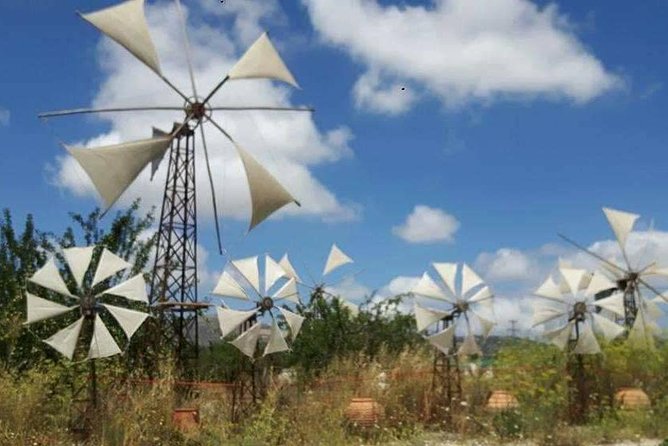
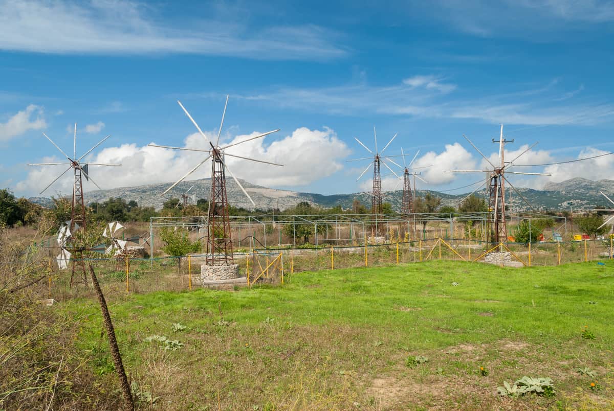
A Lasithi Plateau tour shows the white-sailed windmills, which are really wind-pumps of a local design. Since the 1920s they have pumped water to irrigate the land. Around 10,000 once stood on the plain, but diesel and electric pumps replaced the majority.
The plateau is known for its white-sailed windmills, which stand on the land at the foot of Mount Dikti. Strictly, the machines are wind-pumps rather than windmills. A windpump uses the force of the wind to lift water, and the Lasithi version follows a local design. On a Lasithi Plateau tour, these white sails show how farmers on the plain have drawn water from under the ground.
The water table on the plateau lies close to the surface, because the plain is endorheic and impermeable rock sits just below the ground. A Lasithi Plateau tour crosses this flat floor, where the wind-pumps drew water for the crops. Floodwater from the plateau now flows through a 3.5 km bored tunnel to the reservoir of the Aposelemis Dam. The dam supplies fresh water to Heraklion and Agios Nikolaos.
Around 10,000 wind-pumps worked on the plain in the past. Modern diesel and electric pumps have since taken over, and the majority of the old wind-pumps now stand abandoned. The same change took place in the Broads and the Fens of East Anglia, where diesel or electric pumps replaced the windpumps that drained the land. Film from 1975 records the wind-pumps still in operation, a sight that a Lasithi Plateau tour now finds only in part.
- Type: The machines are wind-pumps with white sails, built to a local design.
- Purpose: They pumped water to irrigate the land of the plain.
- Number: Around 10,000 of them stood on the plateau in the past.
The wind-pumps link the windmill stop on a Lasithi Plateau tour to the water story of the whole basin, from the high water table to the tunnel that takes floodwater away. The sails that remain still mark the fields, and a Lasithi Plateau tour shows them as a record of the way the plateau once watered its land.
Which villages does a Lasithi Plateau tour pass?
A Lasithi Plateau tour passes the villages of the plain, led by Tzermiado, the seat of the municipality, and Agios Georgios, the second biggest village. Psychro lies near the Cave of Zeus, and Saint Konstantinos lies near the Kroustalenia Monastery.
Tzermiado has been the seat of the Oropedio Lasithiou municipality since the 1997 Kapodistrias reform. Before 2006, it was also the seat of the Province of Lasithi, one of the four provinces of Lasithi at the time. Psychro lies close to the Psychro Cave in the Dikti mountains, so a Lasithi Plateau tour reaches this village on the way to the Cave of Zeus.
A Lasithi Plateau tour also reaches Agios Georgios, the second largest village on the plateau, at an altitude of 840 m. It holds a Folklore Museum and a small historical museum pharmacy, along with hotels and small restaurants. The only elementary school on the plateau is here, as is the only kindergarten in the municipality. The population fell from 1,030 in 1981 to 490 in 2011.
Close to Agios Georgios lie the villages of Koudoumalia and Avrakondes. Agios Georgios is a starting point for the climb to Dikti, at 2,148 m, and the E4 walking route runs through the village. To the south, the small Limnakaro plateau serves as grazing land for sheep and goats. In winter, when snow covered the plain, villagers from Agios Georgios moved down to Analipsi on the north coast to grow olives.
- Tzermiado: The village serves as the seat of the Oropedio Lasithiou municipality.
- Psychro: The Psychro Cave, the traditional birthplace of Zeus, lies near this village.
- Saint Konstantinos: The Kroustalenia Monastery, dedicated to the Dormition of the Virgin, stands on a small mound near this village.
- Limnakaro: The small plateau to the south has a double-nave church of the Holy Spirit from the second Byzantine period.
On a Lasithi Plateau tour, burial sites across the plain show a custom set by the ground itself. Because water sits so close to the surface, the dead are commonly housed above ground in stone mausoleums or decorative stone boxes. Families with roots in Agios Georgios now live in Heraklion and Hersonissos.
What is the history behind a Lasithi Plateau tour?
A Lasithi Plateau tour crosses ground settled since Neolithic times, around 6000 BC. Minoans and Dorians followed, Karfi became one of the last Minoan towns, Venice emptied the plain for over two centuries, and Ottoman and Egyptian armies struck it in 1823 and 1867.
The Minoan story of a Lasithi Plateau tour centers on Karfi, just north of the plain, at about 1,100 meters above sea level. Karfi is believed to be the last outpost of the Minoan civilization. It is best known as a large Late Minoan IIIC town, from around 1200 to 1000 BCE. The Dorians seem to have pushed local people into the hills, and here a fragment of Minoan culture survived for about 400 years after the occupation of Knossos.
Venetian rule shaped the plain that a Lasithi Plateau tour crosses. In 1212, the Hagiostephanites brothers rose in revolt on the plateau. In 1284, Venice banned entry and settlement, even for herding sheep. From 1293, the plain stayed empty for over two centuries. Villages were demolished, farming was banned, and natives faced death if they returned. A Venetian manuscript called Lasithi “a thorn in the heart of Venice”. In the early 15th century, refugees from the eastern Peloponnese were allowed to farm it again.
In January 1823, during the Greek War of Independence, Hassan Pasha led Ottoman and Egyptian forces onto the plateau. They killed a large share of the residents who had not fled to the mountains. In the spring of 1867, during the great Cretan revolt, Pashas Omar and Ismail Selim defeated the rebels, who retreated to the slopes of Dikti. Livestock and crops were destroyed. The Kroustalenia Monastery, seat of the revolutionary committee, was demolished and later rebuilt.
- Revolts: George and Theodore Chortatzes led an uprising centered on the plateau in 1272 or 1273.
- Karfi finds: The sanctuary yielded clay goddesses with raised hands, and the site’s finds are on display in Room 11 of the Heraklion museum.
- Excavation: J. D. S. Pendlebury and the British Archaeology School excavated Karfi in 1937 and 1939.
- 1941–1944: During the Axis occupation, local resistance fighters hid on the peaks around the plateau.
Genetic research links today’s plateau residents to this past. A 2007 Y-DNA study found that samples from the plateau differed significantly from those of lowland Crete. A 2013 mtDNA study of bones from a Minoan ossuary on the plateau, dated to 4,400–3,700 years ago, found the Minoan samples closest to the modern plateau population. The authors judged the results consistent with the plateau serving as a Minoan refugium.
Which crops does a Lasithi Plateau tour pass?
A Lasithi Plateau tour passes a farmed plain where residents earn the bulk of their income from agriculture and animal farming. On Katharo, a plateau 300 m higher that drains into the Lasithi plain, the soil yields vegetables, potatoes, grapes, pears and apples.
The fields on a Lasithi Plateau tour owe their fertility to snow. Alluvial run-off from melting snow built up the soil of the plain. The plateau is endorheic, and impermeable rock lies just below the surface. The water table sits close to the ground, and for this reason burials commonly take place above ground, in stone mausoleums or decorative stone boxes. Across Crete, agriculture still plays an important role beside tourism.
The drainage network along a Lasithi Plateau tour dates to Venetian rule. Between 1514 and 1560, the Venetians built a large system of drainage ditches, the linies, to protect the harvest, and the ditches remain in use. They carry water to Honos, a sinkhole at the west edge of the plateau that feeds the river Aposelemis. Floodwater leaves through a 3.5 km tunnel to the Aposelemis Dam reservoir, the primary fresh water supply for Heraklion and Agios Nikolaos.
Two smaller Dikti plateaus sit above the plain of a Lasithi Plateau tour. Katharo lies at an average altitude of 1,150 m, 12 km from Mesa Lasithi by a rough mountain road, and its waters drain through the Havgas gorge into the Lasithi plain. Limnakaro, a small plateau south of Lasithi at about 1,120 m, serves mainly as grazing ground for sheep and goats. It grows walnut, pear, apple and chestnut trees.
- Neolithic farming: The first settlers of Crete brought domesticated cereals and legumes, plus cattle, sheep, goats and pigs.
- Cheese: Dairy products matter to the Cretan economy, with specialty cheeses such as mizithra, anthotyros and kefalotyri.
- Vines and orchards: Viticulture and olive groves are significant across Crete, beside oranges, citrons, avocadoes and bananas.
- Herbs: Crete’s indigenous herbs include sage, rosemary, thyme, oregano and the endemic Cretan dittany.
Fruit and vegetables from the farmland around a Lasithi Plateau tour fit the base of traditional Cretan cuisine. That base was plant food: fresh and dried fruit, pulses, wild herbs and rough cereals, with olive oil as the main fat. Sfougato, an omelette of vegetables, mostly potatoes, zucchini and onions, with cheese, ranks among the island’s specialties.
When is the best season for a Lasithi Plateau tour?
A Lasithi Plateau tour reaches an average altitude of 840 m. Winters there can be harsh, and snow on the plain and the peaks around it can last into mid-spring, so the months from late spring to early autumn fall outside the snow season.
Crete falls mainly in the hot-summer Mediterranean climate class, with hot semi-arid areas in the south and east. Higher ground belongs to the cold-summer Mediterranean class, and peaks above 2,000 m can carry a continental climate. On the mountains, snow falls commonly between November and April, while low-lying areas rarely see it. A Lasithi Plateau tour climbs from the coast to a plain at 840 m under Dikti peaks that top 2,000 m.
Snow has sent people down from the high ground around a Lasithi Plateau tour. In past winters, when snow covered the plateau, villagers from Agios Georgios moved down to Analipsi, a settlement on the north coast 5 km west of Hersonissos, and cultivated olives there. Katharo has no winter residents because of its altitude, while about 500 people, mainly shepherds, stay there in summer.
Summer is the hot season on Crete, and water runs short at that time of year. During the Greek Civil War, the summer season sharply limited water sources for rebels in the Dikti and Psilorites ranges. Summer demand for water on the north coast outweighed strong local opposition to the Aposelemis Dam. In summer, swallows are found throughout Crete, and eagles can be seen in Lasithi.
- Island winters: Winter across Crete is fairly mild, and the air can be quite humid near the sea.
- Sunshine: South Crete receives more than 3,257 hours of sunshine a year, the highest total in Greece.
- Warm records: Crete holds European heat records among W.M.O. stations for October, November, January and February.
- Winter water: The Aposelemis Dam, which takes floodwater from the plateau, overflowed for the first time in February 2019.
Walking routes give a Lasithi Plateau tour a reason to favor the warmer months. The European walking route E4 crosses Limnakaro, and a mountain shelter stands at 1,350 m in the Anestasi area to its southwest. Agios Georgios serves as a starting point for an ascent of Dikti. Snow on these mountains can last into mid-spring, so dates after mid-spring avoid that snow.
What do travelers ask about a Lasithi Plateau tour?
A Lasithi Plateau tour raises questions about the regional unit, the Dikti range, a Knossos visit and the origin of the name. The plateau belongs to Lasithi, the Dikti range tops out at 2,148 m, and records show the name Lasithi by 1211.
Which regional unit covers a Lasithi Plateau tour?
The plateau visited on a Lasithi Plateau tour lies in Lasithi, the easternmost regional unit of Crete, east of Heraklion. Its capital is Agios Nikolaos, and its other major towns are Ierapetra and Sitia. Of its four municipalities, Oropedio Lasithiou covers the plateau. Before 2006, the Province of Lasithi held almost the same ground, with its seat at Tzermiado.
How high do the Dikti mountains rise above a Lasithi Plateau tour?
The Dikti range around a Lasithi Plateau tour reaches 2,148 m at Spathi, its highest point. Afentis Christos rises to 2,141 m and Lazaros to 2,085 m. Pines, Kermes oaks, cypresses, holm oaks and Cretan maples cover large parts of the range. In antiquity, the range was called Aigaion oros.
Can a Lasithi Plateau tour pair with Knossos on another day?
Yes. The plateau lies about 70 km east of Heraklion, and Knossos sits on the southern outskirts of that city, about 5 km south of its historic center. Visitors can arrange Knossos tickets for the palace site, and the Heraklion Archaeological Museum holds the great majority of finds from Knossos and other Minoan sites.
How old is the place name behind a Lasithi Plateau tour?
The place name Lasithi appears in records as early as 1211, six years after the Venetians first reached Crete in 1205, and derivations from a Venetian “la” prefix are judged unlikely. Scholars have speculated that ra-su-to, a word in Linear B, stands for an unattested ancient Lasynthos. Under Turkish rule, the area went by the name Laşid.
Featured photo: Cayambe, CC BY-SA 4.0, via Wikimedia Commons.