A Chios tour explores the North Aegean island of mastic, from the castle quarter of Chios Town and the walled mansions of Kampos to the painted mastic village of Pyrgi, the fortified lanes of Mesta, the monastery of Nea Moni and the beaches of the coast. This post covers what a Chios tour includes, Chios Town, Kampos, mastic and the mastic villages, Nea Moni, Anavatos, the beaches, the north of the island and the best season. It is one of the island tours in Greece on Greece VIP.
Each section ends with a Chios tour that can be booked online.
What does a Chios tour include?
A Chios tour covers the main town and its castle, the Kampos mansions, the mastic villages of the south, the Nea Moni monastery and the coast. The island lies in the North Aegean, close to the Turkish shore.
Chios is the fifth largest Greek island. It lies in the northern Aegean and belongs to the North Aegean region. The Chios Strait separates it from the Anatolian mainland, and the Turkish town of Çeşme faces the port across the water. The island is crescent shaped, 50 km long from north to south and 29 km wide at its widest.
The terrain is mountainous and arid, with a ridge running the length of the island. Pelineon and Epos, the two largest peaks, stand in the north. A range of smaller peaks called Provatas divides the centre between east and west. One national road, the EO75, serves the east, and a Chios tour reaches the other districts along 23 provincial roads.
The southern region holds the Mastichochoria, seven villages of Mesta, Pyrgi, Olympi, Kalamoti, Vessa, Lithi and Elata. A Chios tour reaches villages built between the 14th and 16th centuries, with fortified gates and narrow streets against pirate raids. Nea Moni, a monastery from the 11th century and a UNESCO World Heritage Site, stands in the island centre between Avgonyma and Karyes.
- Name: Ophioussa and Pityoussa were ancient names.
- Export: Chios is notable for mastic gum.
- Symbol: Chian coins carried a sphinx.
A Chios tour moves through the island’s history. Byzantine rule held the island for seven centuries after 395 AD, and the Genoese ruled it from 1304 to 1566. Ottoman rule lasted until 1912, when the Greek Navy landed at Chios. Nea Moni keeps mosaics from the reign of Constantine IX.
What does a Chios tour show in Chios Town?
A Chios tour in Chios Town shows the Castle of Chios, a Byzantine and Genoese fortress, the Korais Library and the neoclassical town rebuilt after the 1881 earthquake. The town is the capital and main port of the island.
The Castle of Chios stands at the northern end of the harbour and is built of reddish local stone. A Chios tour reaches walls that the Byzantines began in the 10th century. The surviving walls date from the Genoese and Venetian periods, with inscribed dates running from 1404 to 1522. A dry moat guards the thicker northern and western sides.
The castle walls collapsed in an earthquake in 1389. The Ragusan architect Leonardo d’Andrea rebuilt them in 1401 and 1402 with a second wall, a triple outwork and a double moat. The Genoese garrison withstood a major Venetian assault in 1430. The castle had three main gates: the Porta Maggiore, a northern postern and a water gate on the harbour.
A Chios tour passes Saint George of the Fortress church, which stands on a Byzantine site from the 10th or 11th century. Piyale Pasha turned it into the Old Mosque in 1566, and it later became Aghios Georgios. The Bayrakli Mosque dates from 1891 and 1892. Turkish baths with vaulted roofs and the Kria Vrisi water tank lie in the north.
- Kastro: The walled quarter housed the garrison.
- Library: The Korais Library is a town landmark.
- Centre: Aplotaria is the main shopping street.
A Chios tour in the town passes the Archaeological Museum, the Byzantine Museum and the Maritime Museum. Adamantios Korais, whose archive the library keeps, was born in Smyrna to a father of Chian descent. Merchants from Chios helped publish his works. Buildings on the promenade show the influence of nearby Smyrna.
Why does a Chios tour stop in Kampos?
A Chios tour stops in Kampos because this plain holds 19th century mansions behind high walls and citrus groves of oranges and mandarins. Wealthy Chian Greek and Genoese families began building houses there during the Genoese rule of the island.
Kampos, or Kampochora, means plain in Greek. Together with the main town and Vrontados, it forms one of the main population centres midway up the east coast. Since the 2011 local government reform it has been a municipal unit within the municipality of Chios. The area covers just over 50 square kilometres and counted 3014 residents in the 2021 census.
The Chian nobility lived in the Kampos, an area of fortified estates and citrus orchards. Imperial charters known as Golden Bulls granted these families tax exemptions and vast estates there. The Zaccaria lords confirmed the privileges of the Greek nobility and let them keep their estates. The Chian estates stood in fee simple, a rare deviation from Ottoman land law.
The Ottoman reprisal of 1822 pillaged or burned the ancestral estates in the Kampos and the mansions in the Castro. Survivors fled to Syros, where they helped found the city of Ermoupoli, and to other European centres. About eighty heads of the noble families were taken hostage. A Chios tour in Kampos crosses the plain that held those ancestral estates.
- Seat: Chalkeio was the former municipal seat.
- Towns: Dafnonas and Vasileonoikon are large settlements.
- Produce: Mandarins and olives travel by merchant ship.
A Chios tour joins Kampos with the castle quarter of the town, because the same noble families used both. In the city, they lived in the fortified citadel and were called Castrini. In the countryside, they lived on the Kampos estates. The Rallis, Rodocanachi and Negroponte families belong to this class.
Why does a Chios tour centre on mastic?
A Chios tour centres on mastic because the resin of the mastic tree is cultivated regularly only in the southern part of the island, where 24 villages grow it, and the European Union protects the Chios name for it.
Mastic comes from Pistacia lentiscus, an evergreen shrub that grows up to four metres tall. The leaves are leathery, and the fruit turns from red to black. The resin is ivory in colour and hardens in cold weather into brittle, translucent drops. Chewed, it softens into a bright white gum with a bitter first taste and a flavour like pine.
The harvest is called kentos and runs through the summer. Growers clear the ground around the trees and sprinkle it with calcium carbonate. Every four or five days, they cut five to ten incisions in the bark of each tree. The first crystals harden and fall after 15 to 20 days, so a Chios tour in summer passes trees in production.
The European Union grants Chios mastic a protected designation of origin for its production. A growers’ cooperative founded in 1938 holds the exclusive management of Chios mastic in Greece and abroad, and twenty primary cooperatives belong to it. UNESCO lists the know-how of cultivating mastic as intangible cultural heritage, and a Chios tour visits the villages that hold that know-how.
- Name: Growers call it tears of Chios.
- Cleaning: Farmers wash the tears in spring water.
- Church: Orthodox holy oil contains mastic.
Under the Byzantine Empire the trade became the Emperor’s monopoly, and under the Ottomans the Sultan gathered the finest crop. Mastic was worth its weight in gold, and the Turkish name of the island, Sakız Adası, means gum island. A Chios tour follows a trade that rulers guarded for centuries.
What does a Chios tour show in Pyrgi?
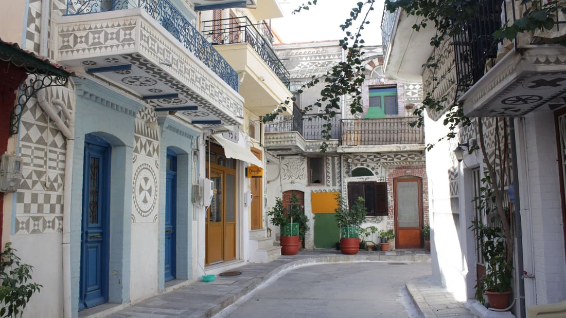
A Chios tour shows Pyrgi, the painted village and traditional seat of the mastic villages in southern Chios, where black and white geometric motifs called xysta cover the house facades and narrow vaulted lanes keep a medieval character.
Pyrgi is one of the biggest villages on Chios and lies in the south, 25 km from the island’s capital. It is the traditional seat of the mastic villages and the seat of the former Mastichochoria municipality, the largest on the island by land area. The 2021 census counted 1,063 inhabitants. Mastic is a major part of the local economy.
Pyrgi is known as the painted village because of the decoration on its houses. The decoration consists of black and white motifs in different shapes, and residents call these facade patterns xysta. The village stands out from the other mastic villages because its houses are worked with these motifs. A Chios tour reads the xysta along the narrow village streets.
Pyrgi is possibly a medieval settlement built before the 10th century. It gathered residents from different villages who settled there to avoid pirate raids. Documents of the 11th, 14th and 15th centuries mention the village. The earthquake of 1881 did not damage it, so Pyrgi keeps its medieval style. A Chios tour in Pyrgi therefore shows a defended medieval settlement.
- Tower: A central tower rises 18 metres.
- Walls: Four corner towers mark the walls.
- Churches: Agioi Apostoloi, Koimisis Theotokou and Taxiarchis.
A white earth found near Pyrgi was famed since antiquity as Chian earth and served as an astringent and cosmetic. It ranked below the earth of Lemnos, which was thought protective against venoms and poisons. A Chios tour in Pyrgi meets an old trade in earth beside the trade in mastic.
What does a Chios tour show in Mesta and Olympi?
A Chios tour shows Mesta and Olympi, fortified mastic villages of southern Chios, where narrow streets, high walls and fortified gates protected residents from pirate raids, and where Mesta keeps a pentagonal perimeter and a church in the centre.
Mesta is a village castle. It belongs to the Mastichochoria municipal unit in the southwest of Chios, where Kalamoti, Armolia, Mesta and Lithi are the next largest villages after Pyrgi. The unit’s population was 3,384 at the 2021 census. The unit includes the port of Limenas. A Chios tour here passes villages built as strongholds around the mastic crop.
Builders possibly raised Mesta in the 12th century, in the Byzantine era. Narrow, labyrinthine streets and a pentagonal fortified perimeter repelled pirate raids. Under Genoese rule on Chios, between 1346 and 1566, the fortifications were reinforced. The church of the Older Taxiarchi stands at the heart of the village and was built in 1794. The medieval architecture remains well preserved.
Olympi stands among the seven main mastic villages, with Mesta, Pyrgi, Kalamoti, Vessa, Lithi and Elata. The mastic villages look like fortresses and stand out of sight from the sea. High walls surround them, and no doors open at street level, so residents entered by ladders. The design protected the sap. A Chios tour in Olympi follows this defensive plan.
- Distance: Chios town lies 35 km away.
- Coast: The sea is 4 km away.
- Elevation: The village stands at 120 metres.
Mesta villagers were killed or captured in the Chios massacre of 1822, and later releases followed because mastic agriculture mattered to the Ottomans. In 2012, a wildfire from the south threatened the Mastichochoria and its trees. The same villages that withstood pirates lived through both a massacre and a fire.
Why does a Chios tour visit Nea Moni?
A Chios tour visits Nea Moni because the eleventh-century monastery holds mosaics ranked among the finest Macedonian Renaissance art in Greece. UNESCO inscribed the monastery on its World Heritage List in 1990, and it stands inland on Chios.
Byzantine emperor Constantine IX Monomachos and Empress Zoe built Nea Moni in the mid-11th century. Tradition places the site where three monks, Nikitas, Ioannes and Iosif, found an icon of the Virgin Mary hanging from a myrtle branch. Constantine lived in exile on Lesbos, and the monks described a vision of him becoming emperor. He took the throne in 1042.
The complex stands on Provateio Oros, a mountain about 15 kilometres from Chios town. The monastery is dedicated to the Theotokos. Its mosaics rank with those at Daphni and Hosios Loukas. A Chios tour includes the monastery for its mosaic artwork. The main church was inaugurated in 1049, and the complex was finished in 1055, after the death of Constantine.
On a Chios tour, the katholikon is the central structure, dedicated to the Dormition of the Virgin Mary. Its main church has an octagonal plan, found in Chios and Cyprus. The complex covers about 17,000 square metres and holds two smaller churches, monks’ cells and an underground cistern. A defensive tower in the north-eastern corner once served as a library.
- Monks: up to 800 belonged around 1300.
- Estates: they covered one third of Chios.
- Museum: a small museum opened in 1992.
In 1822 Ottoman troops stormed the monastery, where 2,000 people had taken refuge, and set fire to the templon, the wooden furnishings and the roof. An earthquake in 1881 collapsed the dome. The monastery became a convent in 1952. A Chios tour shows a monastery rebuilt after fire and earthquake.
What does a Chios tour show at Anavatos?
A Chios tour shows Anavatos, a medieval village on the island of Chios that stands abandoned. A medieval fortress rises above the village. The village was left empty after the Chios massacre of 1822 and the earthquake of 1881.

Anavatos lies 16 kilometres from Chios town. The village dates to the Byzantine era and is linked to the workers of Nea Moni, the monastery in the island’s interior. Its Greek name is Ανάβατος. Chios remained Ottoman until 1912. A Chios tour covers the village together with the monastery, because the two sites share a history of 1822 and 1881.
For over 2,000 years, merchants and shipowners from Chios were prominent in trade and diplomacy across the Black Sea, the Aegean and the Mediterranean. The Ottoman Empire allowed the island almost complete control over its own affairs, because Chian trade and mastic were of great value. At its closest, Chios lies only 6.7 kilometres from the Anatolian mainland.
In March 1822 armed Greeks from neighbouring Samos landed on Chios and attacked the Turks, who retreated to the citadel. A Turkish fleet under Kapudan Pasha Nasuhzade Ali Pasha arrived on 22 March and looted the town. Orders to burn the town came on 12 April. Over the next four months an estimated 30,000 Turkish troops arrived on Chios.
- Delacroix: painted Scenes from the Massacres of Chios.
- Hugo: wrote L’Enfant about the massacre.
- Kanaris: burned the Ottoman flagship in 1822.
The island had 100,000 to 120,000 people, and about four-fifths were killed, enslaved or displaced. At least 25,000 were killed, 45,000 enslaved and 10,000 to 20,000 fled. The massacre outraged the Western world. A Chios tour at Anavatos places the village inside that history.
Which beaches does a Chios tour stop at?
A Chios tour stops at the sandy beaches of Karfas, a small town on the east coast, and at the shore near Emporio in the far south of the island, where a prehistoric settlement once stood beside the sea.
Karfas is a small town on the eastern coast of Chios, 7 kilometres south of Chios town, in the Kambos region. Tourists flock to Karfas more than to any other area of Chios, drawn by its cosmopolitan, sandy beaches. Studios, residences, clubs, restaurants and general nightlife line the same town. A Chios tour reaches the town of Karfas for that coastline.
The permanent population of Karfas was 386 at the 2021 census, yet thousands of tourists arrive in the summer months. Visitors outnumber residents at that time. July and August are the reported peak of the tourist season. The small village of Ayia Ermioni lies nearby and is also a large tourist spot. Both places draw visitors on a Chios tour.
Emporio is a prehistoric settlement in the Mastichochoria municipality, in the south-eastern part of Chios. Pyrgi is the largest village nearby. The modern village nearby is called Emborios, a coastal town with 47 inhabitants in 2011. The site offers a fertile valley, drinking water and a natural harbour close by, which drew settlers in early Neolithic times, around 6000 BC.
- Airport: it lies 3 kilometres from Karfas.
- Kato Phana: an ancient site in the south-west.
- Villages: Kataraktis and Nenita are fishing villages.
A fortified settlement stood on the peninsula south of Emborios Bay, dating to the end of the Chalcolithic. Another settlement grew near the beach outside the fortress and lasted until the final phase of the Mycenaean culture, around 1100 BC. A Chios tour at Emporio shows ruins beside the shore.
What does a Chios tour show in the north of the island?
A Chios tour in the north of the island shows Vrontados, a coastal town beside Homer’s stone, and Volissos, the largest village of the northwest, where a Byzantine castle crowns the hill. Both places link Chios to Homer.
Vrontados is a coastal town on the eastern side of Chios, north of Chios Town. It forms the seat of the Omiroupoli municipal unit and has a strong tradition in merchant seafaring. The town lies so close to the capital that it counts as a suburb, so a Chios tour of the north begins at the edge of the capital.
On the north side of the Vrontados coast stands Homer’s stone, a natural rock throne where, according to legend, the poet sang and taught. An archaeological site known traditionally as Teacher’s Rock supports the link between Vrontados and Homer. Pindar is credited with naming Chios and Smyrna as the places where Homer originated, and the Chios tradition keeps that claim.
Volissos is the largest village in the northwest of Chios, 40 km from Chios Town. The village is built in amphitheatrical style on a hill, and a Byzantine castle from the medieval period stands on top. The castle has a trapezoid shape with six circular towers. Herodotus is said to mention Homer living and writing his epics in this village.
- Aepos: Echoing thunder named Vrontados.
- Cybele: Daskalopetra is her earliest known temple.
- Limia: This port connects Volissos and Psara.
Volissos is the birthplace of Saint Markella of Chios. Her nameday falls on 22 July, when worshippers gather at her monastery, where holy water springs from a hole beside the sea. Tradition adds that Christopher Columbus visited Vrontados to study nautical charts with experienced seamen before his voyages to the Americas.
When is the best season for a Chios tour?
A Chios tour meets a warm, moderate Mediterranean climate, a mastic harvest from early July to early October, and the rocket war of Vrontados at Orthodox Easter. Summer highs reach 30 °C and the January low is 7 °C.
Chios has a temperate Mediterranean climate, classed as Köppen Csa, with modest variation because the surrounding sea stabilises temperatures. Readings above 40 °C or below freezing can sometimes be encountered. Steady breezes of 3 to 5 metres per second blow through the year, predominantly the northerly Meltemi or the southwesterly Sirocco. A forest fire in August 2012 hit mastic groves.
The mastic harvest on Chios takes place from the beginning of July to the beginning of October. The clear drops of resin hang from the trees and sparkle in the sunlight, which is why mastic is called the tears of Chios. A Chios tour in this harvest period meets the crop at its source, in the villages of the south.
Orthodox Easter falls later in the year than the Western date. On that day Vrontados holds the rouketopolemos, or rocket war. Two rival parishes, Saint Mark’s and Panagia Ereithiani, fire tens of thousands of homemade rockets at each other’s belfry. Hundreds of rockets are lined up on angled, grooved platforms. Each parish claims victory, so the contest returns the next Easter.
- Kentos: This word names the mastic harvest.
- Hilltops: Two churches stand 400 meters apart.
- Shields: Metal sheets and mesh protect churches.
Local legend dates the rocket war to the Ottoman period, and folklore says real cannons were fired until Ottoman authorities prohibited them in 1889. The event was cancelled in 2016 after complaints of property damage. A Chios tour at Easter meets the revived event, which returned in 2017 with new rules.
What do travelers ask about a Chios tour?
A Chios tour starts on the fifth largest Greek island, which has one regional airport, a mastic region in the south and a strait that separates it from the Anatolian mainland. Vrontados lies north of Chios Town, and Volissos lies in the northwest.
Which airport serves a Chios tour?
Chios Island National Airport is the regional airport of Chios. It lies in Kampos, south of Chios Town, and carries the name of Homer. The airport opened on 4 August 1969, and its runway measures 1,511 by 30 metres.
How far does a Chios tour reach?
The island is kidney-shaped, 50 km long from north to south and 29 km wide at its widest. It covers 842 km2, and a mountain ridge runs its length. The two largest peaks, Pelineon and Epos, rise in the north.
Where does a Chios tour find mastic?
The Mastichochoria, or mastic villages, lie in the southern region of the island. Mesta, Pyrgi, Olympi, Kalamoti, Vessa, Lithi and Elata have controlled mastic production there since the Roman period. Armolia, Myrmighi and Kalimassia lie between Chios Town and the group.
Is Turkey near a Chios tour?
The Chios Strait separates the island from the Anatolian mainland. The Çeşme peninsula on the Turkish coast lies eight nautical miles from Chios, and Chios is twinned with Çeşme. Erythrae, the traditional competitor of Chios, was a city on that mainland.
Which museums fit a Chios tour?
Four museums are listed for Chios: the Byzantine, Mastic, Archaeological and Maritime museums. The Mastic Museum keeps a permanent exhibition on mastic production and history. The Archaeological Museum holds a fifth-century inscription for Heropythos, which traces his family back over fourteen generations.
Featured photo: Eva-tzi, CC BY-SA 4.0, via Wikimedia Commons.