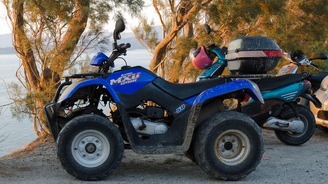
A Santorini ATV tour drives a four-wheeled quad along the roads of the volcanic island, from the white villages on the caldera rim to Oia, Pyrgos and the summit of Profitis Ilias, the red and black beaches of the south, the Bronze Age town of Akrotiri, Ancient Thera and the vineyards of Assyrtiko. This post covers what a Santorini ATV tour includes, the licence rules, the route, each stop, safety, the other ways to see the island and the best season. It is one of the island adventures in Greece on Greece VIP.
Each section ends with a Santorini ATV tour or island tour that can be booked online.
What does a Santorini ATV tour include?
A Santorini ATV tour puts each rider on a four-wheeled quad bike for a self-drive route over the island road network, with a tour leader setting the line. The route joins caldera villages, inland hill settlements and volcanic beaches, and each rider steers a machine.
The island covers about 73 square kilometres, so one outing can cross it from the north coast to the southern cape. Fira, the capital, is the transport terminus, and the main roads radiate from there towards Oia in the north, Kamari and Perissa in the east and Akrotiri in the south. Riders meet the traffic of a working island rather than a closed circuit.
The machines are quadricycles, which Greek law treats as motor vehicles, so a driving licence is required for every machine on the route. Helmets are compulsory for riders of light and heavy quadricycles. A rented quad carries the rider and, where the machine allows it, a passenger who also wears a helmet. The Santorini ATV tour format is self-drive, so the person who books is the person who steers.
- Vehicle: A quad bike is a four-wheeled machine that Greek categories treat as a moped, a light quadricycle or a heavier quadricycle.
- Route: Fira sits at the centre of the network, with Oia eleven kilometres north and Akrotiri fifteen kilometres south.
- Licence: A driving licence is required for every type of motorised vehicle in Greece.
A Santorini ATV tour follows the asphalt network used by island traffic, so the experience rests on the machine, the licence and the helmet rules that Greek law applies to quadricycles. The island is small enough that a single route can touch the caldera rim, the inland villages and the volcanic coast.


What licence does a Santorini ATV tour need?
A Santorini ATV tour needs a full driving licence for the machine being ridden. Greek rules place mopeds and light quadricycles in category AM, with a minimum age of sixteen, and heavier vehicles in categories that carry higher age limits. Helmets are compulsory on light and heavy quadricycles.
Greek licence categories are set by vehicle type, and a Santorini ATV tour follows them without exception. Category AM covers mopeds and light quadricycles from the age of sixteen. Category A1 covers motorcycles with a cylinder capacity of no more than 125 cubic centimetres, a power of no more than eleven kilowatts and a power-to-weight ratio of no more than 0.1 kilowatts per kilogram, from eighteen. Category B covers cars and other motor vehicles of no more than 3,500 kilograms, also from eighteen.
Visitors from outside the European Union need an International Driving Permit unless their home country has a mutual recognition agreement with Greece. The current list of mutual recognition countries includes the United States, Canada, Australia, Japan, South Africa and South Korea. A licence from one of those countries can be used temporarily in Greece or exchanged for a Greek licence.
- Category AM: Mopeds and light quadricycles, with a minimum age of sixteen.
- Category A1: Motorcycles up to 125 cubic centimetres and eleven kilowatts, from eighteen.
- Category B: Motor vehicles up to 3,500 kilograms, from eighteen.
Greek rules for a Santorini ATV tour depend on the vehicle, not on the island. A machine in the AM band needs the AM licence, and a heavier quadricycle needs the category that matches it, with helmets worn throughout. A rider without a helmet faces a fine, five penalty points and a driving licence withdrawal of thirty days.
Which route does a Santorini ATV tour follow?
A Santorini ATV tour follows the island road network from Fira north to Oia and south to Akrotiri. Fira is the transport terminus of the island, with Oia eleven kilometres to the north and Akrotiri fifteen kilometres to the south.
The island covers about 73 square kilometres, and its road network is built around the caldera. Fira stands on the western rim, roughly 400 metres above the water. From the capital the main road turns north along the rim towards Imerovigli and Oia, and a second axis runs east and south towards Kamari, Perissa, Emporio and Akrotiri. Side roads climb inland to Pyrgos and Megalochori.
The caldera itself measures about twelve by seven kilometres, with cliffs of 300 metres on three sides and a maximum depth of 385 metres. From Fira the view runs along an eighteen-kilometre rim from Cape Akrotiri to Cape Agios Nikolaos. A route that starts and ends at the capital can touch the rim, the eastern beaches and the southern peninsula without leaving the asphalt. A Santorini ATV tour can cover the whole ring in one ride.
- Northern arm: The road from Fira to Oia runs along the caldera side.
- Southern arm: The road to Akrotiri passes Emporio and the southern beaches.
- Inland arm: Pyrgos sits seven kilometres from the capital, and Kamari eight kilometres to the east.
A Santorini ATV tour is bounded by the caldera, so the geography shapes every route. The rim villages sit on one line, the beaches on another and the hill villages on a third, and the distances between them are short. That compact layout lets a rider move from a caldera village to a volcanic beach and then to an inland hilltop within one continuous ride.
What does a Santorini ATV tour see in Oia?
A Santorini ATV tour reaches Oia at the northwestern edge of Santorini, where the village follows the caldera rim. The route brings riders near the ruined Venetian castle, while Amoudi Bay sits in the volcanic cliffs below the town.
Oia extends for almost two kilometres along the northern edge of the caldera. It stands between 70 and 100 metres above sea level, with Phinikia immediately east and Tholos about 500 metres north. Fira is eleven kilometres away. The village rises across the steep caldera slope, where narrow paths and a central square sit above the water. A Santorini ATV tour uses the road approach, not the paths inside the settlement.
At the highest point of Oia, the ruined castle is also called Fort Londsa. It was the seat of the Argyri family under Venetian rule and formed part of the same defensive system as Pyrgos. Amoudi Bay lies below the town in western Santorini’s high volcanic cliffs. The bay is linked to Oia by 200 steps, while the harbour route below the village is reached by 300 steps.
- Caldera rim: A Santorini ATV tour reaches Oia, which extends for almost two kilometres along the northern caldera edge.
- Castle: Fort Londsa is the ruined Venetian castle at the highest point of the village.
- Amoudi Bay: The harbour village of Ormos Ammoudi below Oia keeps a ferry link to Therasia.
A Santorini ATV tour offers a road-based arrival at Oia, then leaves the detailed exploration to walking. That division matters because the paths of Oia are narrow and become congested during the tourist season. The quad gives access to the northern rim and the views across the caldera, while the castle ruins and the steps to Amoudi Bay belong to the pedestrian part of a stop.
What does a Santorini ATV tour see in Pyrgos and Megalochori?
A Santorini ATV tour reaches Pyrgos, an inland village seven kilometres from Fira, and passes Megalochori on the southern road. Pyrgos rises around the ruins of a Venetian castle, while the fortified settlements of Santorini include churches at their entrances and narrow streets within their walls.
Pyrgos Kallistis is a village of Santorini with a recorded population of 1,078 in the 2021 census. It is built on a hill above the central part of the island, seven kilometres from Fira. At its summit are the remains of the Venetian Kasteli, which once served as the administrative centre of the island. Its narrow streets, fortified walls and passages record the layout of a medieval settlement.
Megalochori forms part of the Thira municipal area and sits on the inland side of the southern route. Santorini had five large fortified permanent settlements, known as casteli: Agios Nikolaos at Oia, Akrotiri, Emporio, Pyrgos and Skaros. A church dedicated to Agia Theodosia stood at the entrance to each casteli. Such walls and towers were built when Cycladic settlements faced pirate raids.
- Pyrgos distance: A Santorini ATV tour reaches Pyrgos, seven kilometres from Fira on the inland road.
- Castle: The Venetian Kasteli at Pyrgos was once the administrative centre of Santorini.
- Churches: Each of the five casteli of Santorini had an entrance church dedicated to Agia Theodosia.
A Santorini ATV tour makes the contrast between caldera roads and inland settlements clear. Pyrgos has a hilltop castle and dense pedestrian lanes, while Megalochori joins the road south across the agricultural centre. The useful pattern is simple: ride to the village edge, leave the machine safely, then explore the confined lanes on foot.
Why does a Santorini ATV tour climb Profitis Ilias?
A Santorini ATV tour climbs toward Profitis Ilias because it is the highest mountain of Santorini, at 567 metres. The peak rises above the inland roads, and the Monastery of Profitis Ilias was one of the important monastic centres of the Cyclades in the final Ottoman years.
Profitis Ilias stands in the interior of the island, above the main roads linking Pyrgos, Emporio and the eastern coast. The summit rises far above the caldera villages, which makes the mountain a natural reference point for a road route. The view from the upper slopes brings the caldera, the coast and the central villages below into one broad frame.
The Monastery of Profitis Ilias is tied to the history of the island in the nineteenth century. During the final years of Ottoman rule, it ranked among the important monastic centres in the Cyclades. Sixteen monks from the monastery publicly supported the Greek revolt in 1822. The mountain takes its name from the prophet Elijah, and the route towards the top calls for a steady pace on the island road.
- Height: A Santorini ATV tour climbs Profitis Ilias, the highest mountain of Santorini at 567 metres.
- Monastery: The Monastery of Profitis Ilias was an important Cycladic monastic centre in the final Ottoman years.
- History: Sixteen monks from the monastery declared support for the Greek revolt in 1822.
A Santorini ATV tour gains a broad geographic view by climbing Profitis Ilias. The mountain is not a caldera stop or a beach stop; it is the high point that explains how those two landscapes fit together. From the upper road, the rider can see why the routes spread outward toward the coast, and the descent returns to the villages, the vineyards or the eastern beaches.
Which beaches does a Santorini ATV tour reach?
A Santorini ATV tour reaches the volcanic beaches on the eastern and southern coast of the island. Red Beach, Kamari, Perissa, Perivolos and Vlychada all lie on lava and ash, and their sand or pebbles take colour from the geological layer that erosion has exposed.
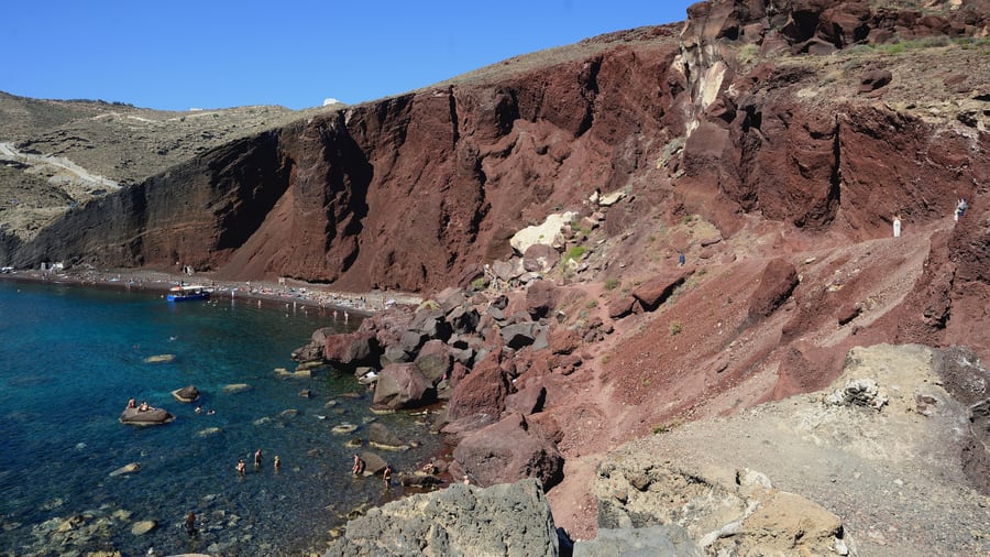
Beach colour on Santorini depends on which layer of solidified lava is exposed. The island carries beaches whose sand or pebbles come from volcanic rock of different tones, including the Red Beach, the Black Beach and the White Beach. Red Beach is a volcanic sand beach where the hue comes from oxidised iron, and its grains are pulverised black and red volcanic rock from the caldera.
Kamari lies eight kilometres from Fira and stretches along a beach covered with black pebbles, the longest beach on the island. It runs from Monolithos to the foot of Mesa Vouno, a mountain of about 400 metres that ranks as the second highest peak of Santorini. Perissa sits thirteen kilometres southeast of Fira, near the same rock. Perivolos and Vlychada lie on the southern coast.
- Red Beach: A Santorini ATV tour reaches a beach where the sand is pulverised black and red volcanic rock.
- Kamari: Kamari has the longest beach of the island, covered with black pebbles.
- Perissa: Perissa sits near Mesa Vouno on the southeastern coast.
A Santorini ATV tour turns the geology of the island into a sequence of stops. Water at the darker beaches is noticeably warmer because the lava absorbs heat. The eastern beaches are the easiest to reach by road, while the southern coast adds the red cliff and the wide black strand at Vlychada.
Does a Santorini ATV tour stop at Akrotiri?
A Santorini ATV tour stops at Akrotiri, where a Bronze Age town lies buried in volcanic ash. The village stands fifteen kilometres south of Fira, and the excavation site sits about two kilometres southeast of it. The lighthouse at the cape dates from 1892.
Akrotiri is a Cycladic Bronze Age settlement on the volcanic island of Santorini. The town was destroyed during the Theran eruption in the sixteenth century BC and buried in volcanic ash, which preserved its wall paintings. Excavation has continued since 1967, when the work began under Spyridon Marinatos. The site has produced frescoes, pottery, furniture, drainage systems and three-storey buildings.
The modern village of Akrotiri is built on the slopes of a hill with views towards the caldera, fifteen kilometres south of the capital. Parts of the settlement stand around the ruins of a thirteenth-century fortress, the Castle of Akrotiri, also called Goulas or La Ponta. The Venetians built it on an existing Byzantine watchtower, and it surrendered to the Ottomans in 1617.
- Buried town: A Santorini ATV tour stops at Akrotiri, a Bronze Age settlement destroyed by the Theran eruption.
- Excavation: Work at the site has continued since 1967.
- Lighthouse: The Akrotiri Lighthouse was built by a French company and recommissioned in 1945.
A Santorini ATV tour uses Akrotiri as the southern anchor of the island route. The road reaches the village, the archaeological site and the cape, so a rider can combine a stop at the covered excavation with the coastal ground beyond. The eruption that buried the town had a volcanic explosivity index of seven and ejected roughly 28 to 41 cubic kilometres of dense rock.
Does a Santorini ATV tour reach Ancient Thera?
A Santorini ATV tour reaches the approach to Ancient Thera, the classical city on the limestone hill of Mesa Vouno. A winding road starts at Kamari, and the ruins sit on a plateau high above the coast between Kamari and Perissa.
Ancient Thera is an archaeological site from classical antiquity on Mesa Vouno. The city was founded by Doric colonists from Sparta. Friedrich Hiller von Gaertringen investigated the site systematically from 1895 to 1904, and later work uncovered the necropolis at Sellada. Its main street ran almost 800 metres and measured between two and four metres wide, wide for its time.
A crowded quarter covered about 100 by 100 metres on the exposed plateau above the rocky coast. Residential areas grouped around an agora roughly 110 metres long and between 17 and 30 metres wide. The Basilike Stoa extended 46 by 10 metres, with ten Doric pillars along its roof. A theatre built into the lower slope seated about 1,500 people, and the city had two seaports, at present-day Kamari and Perissa.
- Location: Ancient Thera occupies the top of Mesa Vouno above Kamari and Perissa.
- Access: A Santorini ATV tour takes the winding road that starts at Kamari and climbs to the site.
- Theatre: The theatre of Ancient Thera seated about 1,500 people.
A Santorini ATV tour treats Mesa Vouno as an eastern stop rather than a caldera one. The climb from Kamari is short but steep, and the plateau opens onto a view over the coast and the beaches below. The return road drops back to sea level near the black pebbles of Kamari, which makes a natural end to the eastern loop.
Which vineyards does a Santorini ATV tour pass?
A Santorini ATV tour passes vineyards that grow Assyrtiko, the white grape indigenous to Santorini, in ash-rich volcanic soil. The vines are trained low in basket shapes called kouloura, and the island makes Vinsanto, a sweet wine that holds protected designation of origin status.
Assyrtiko is a white Greek wine grape indigenous to Santorini, and the vineyards of the island are planted on arid, volcanic-ash-rich ground. Santorini is free of phylloxera because its volcanic soils lack the clay that the parasite needs, so the vines remain ungrafted and centuries old. Growers train them low in basket-shaped kouloura that shield the grapes from strong winds and direct sun. About 1,200 hectares of land on the island are under vine.
The vine training system protects a crop that grows close to the ground. Roots reach deep into calcareous subsoils for moisture during long dry summers. At about the age of 75 a vine is clipped at its roots and a new vine is connected to the rootstock. A Santorini ATV tour crosses this landscape on the roads between Pyrgos, Megalochori and the eastern coast.
- Assyrtiko: A Santorini ATV tour passes vines of the white grape indigenous to Santorini.
- Kouloura: Vines are woven into low baskets that protect grapes from wind and sun.
- Vinsanto: Vinsanto is a sweet wine made mostly from Assyrtiko, with at least 51% of the grape.
Wine is part of the landscape a Santorini ATV tour crosses, not a separate excursion. Santorini wine must contain at least 75% Assyrtiko, and the European Union granted Santorini exclusive rights to the Vinsanto name in 2002. Vineyards sit beside the inland roads, so riders pass them between the caldera villages and the beaches. A dedicated Santorini wine tour adds the cellar visits that a road route does not include.
What does a Santorini ATV tour see on the caldera rim?
A Santorini ATV tour follows the caldera rim through Fira, Firostefani and Imerovigli, with Skaros rock beyond. Fira is the island capital and the road hub, while Imerovigli sits north of it, with narrow paved paths and the ruins of a Venetian castle on Skaros.
Fira is the modern capital of Santorini, a town of whitewashed houses built on the edge of the 400-metre caldera on the western side of the island. Access is mainly by roads on its eastern side, with a zigzag footpath and a cable car from the port. The central square, Plateia Theotokopoulou, holds the bus and taxi station, banks and pharmacies. From the town the caldera view runs for eighteen kilometres.
Imerovigli stands north of Fira on the rim and is crossed by narrow paved paths. Its churches follow Cycladic architecture, including Ai-Stratis in the centre and the Monastery of Saint Nikolaos on the path to Fira. Skaros rock nearby carries the remains of a Venetian castle founded in 1207 by Marco Sanudo. The settlement there grew to more than 200 homes. Firostefani sits between Fira and Imerovigli.
- Fira: A Santorini ATV tour starts in Fira, the island capital on the edge of the 400-metre caldera.
- Imerovigli: Imerovigli stands north of Fira and has 469 permanent inhabitants.
- Skaros: The Venetian castle on Skaros rock was built in 1207 by Marco Sanudo.
A Santorini ATV tour along the rim links the densest historic settlements of the island. The road keeps riders at the edge of each village, and the caldera paths themselves are pedestrian ground. The chapel of Panagia Theoskepasti still stands on the cliffs below Skaros, a reminder that the rim was fortified long before it became a tourist corridor. Santorini hiking tour options cover the footpaths that vehicles cannot use.
How does a Santorini ATV tour stay safe?
A Santorini ATV tour stays safe by keeping to the rules that Greek law sets for quadricycles: a helmet on every rider, a licence for the machine, and a steady speed on narrow island roads. Water and sun protection matter on a dry, exposed island.
Helmets are compulsory for riders of light and heavy quadricycles under Greek law, and this requirement covers passengers too. The penalty for a missing helmet falls on the person steering the machine, whether the rider or the passenger travels bareheaded. Road safety statistics for Greece record 10,553 injury-causing accidents in 2023, with 646 deaths, 659 serious injuries and 12,156 slight injuries.
The roads of the island follow a narrow, curved geography. The inner coast around the caldera is a sheer precipice of more than 300 metres at its highest, and the villages perch on the crest. A Santorini ATV tour reduces risk by riding at a modest pace, leaving generous space on bends and pulling fully off the carriageway before any stop.
- Helmets: A Santorini ATV tour requires helmets for riders of light and heavy quadricycles.
- Water: Santorini has one spring, Zoodochos Pigi, and relies on cisterns and desalination plants.
- Sun: Rainfall on the island averages near 270 millimetres a year, so shade is scarce.
An island route with tight bends leaves little room for error, so a Santorini ATV tour rewards a cautious pace. Helmets, a matching licence, drinking water and full concentration on the road are the practical controls. The South Aegean region recorded the highest road fatality rate per million inhabitants in Greece in 2023, so care on the bends carries a clear purpose.
How does a Santorini ATV tour compare with other ways to see the island?
A Santorini ATV tour sits between public transport and private vehicles. Buses run from Fira across much of the island, cars and scooters share the same roads, boats serve the caldera and the islets, and walking covers the rim paths that no vehicle can use.
The central bus station stands in Fira, and bus services link the capital to the main settlements of the island and to the visitor spots. Ferry connections run between Santorini and Piraeus throughout the year, with up to five direct crossings in summer. The island has two ports, Athinios for ferries and Skala, the old port, and an airport about six kilometres southeast of downtown Thera.
Boats cover what roads cannot. Tour boats leave Skala for Nea Kameni and other destinations, and cruises can be arranged from Oia or Fira. Walking handles the caldera villages, because those paths are narrow and steep; at Oia the descent to the port runs down 300 steps. Donkeys and mules once carried visitors up from Skala, and the use of animals for tourist transport has drawn criticism from animal welfare organisations.
- Buses: The central bus station is in Fira, and services reach the main settlements.
- Cars and scooters: These use the same road network as a quadricycle, with the same traffic.
- Walking: The caldera paths between the rim villages are for pedestrians only.
The comparison turns on control and reach. A Santorini ATV tour gives a rider command of the timing and the line, which buses cannot offer, while a car offers shelter and a scooter offers speed. Walking remains the only way into the caldera villages and the steep lanes at Oia. Santorini private tour travel suits visitors who prefer a driver to a machine of their own.
What does a Santorini ATV tour see in Emporio?
A Santorini ATV tour reaches Emporio, a village 12 km from Fira that sits, by distance from the capital, between Pyrgos and Perissa. Emporio keeps the old Goulas Castle and a group of churches, and it gives its name to a community of four villages.
The 2021 census counted 3,704 permanent inhabitants in the community of Emporio, against 1,078 in the village of Pyrgos and 15,480 for Santorini as a whole. The community takes in four villages: Emporeio, Perissa, Agios Georgios and Exomytis. A Santorini ATV tour that stops here reaches a settled community near the Profitis Ilias mountains, not a lone hamlet on the road.
Emporio is one of the five kasteli of Santorini, the large fortified permanent settlements that islanders built while pirates plundered harvests in the 15th and 16th centuries. The outer walls had no openings and formed a protective perimeter. The old Goulas Castle belongs to that defensive past, and the machine stays outside the walls, because the lanes of a fortified village suit walking.
Churches mark the same story. Saint Nicholas Marmaritis is named among the churches of Emporio. Each of the five kasteli had a church of Agia Theodosia, the Protector-Saint of castles, at its entrance. Perissa, in the same community, keeps the remnants of the Early Christian church of Saint Irene, whose contracted form is the present name of the island. Saint Irene is therefore the saint behind the name of the island that a Santorini ATV tour crosses.
- Distance: On a Santorini ATV tour, Pyrgos lies 7 km from Fira, Emporio 12 km and Perissa 13 km.
- Castle: The old Goulas Castle stands in Emporio.
- Ridge: The Gavrillos ridge is one of the places where the older non-volcanic basement shows.
A Santorini ATV tour places Emporio between two neighbours that are easy to name. Pyrgos rises on its hill with the ruins of a Venetian Kasteli, and Perissa lies by the Aegean near the Messa Vouno rock. The quad links the three stops by road, while the castle, the churches and the lanes belong to a walk on foot.
When is the best season for a Santorini ATV tour?
A Santorini ATV tour works best in spring and autumn, when the heat eases and the roads stay dry. Santorini has a hot semi-arid climate with Mediterranean features, mild winters and a very dry summer, and summertime traffic on the island is at its heaviest.
Santorini has a hot semi-arid climate with Mediterranean characteristics, including dry summers and relatively wetter winters. Average annual precipitation is about 270 millimetres and the average annual temperature is about 19 degrees Celsius. Mean daily maximum temperatures reach 30.1 degrees in July and 30.2 degrees in August, and the record high stands at 39.4 degrees. June averages 27.9 degrees and September 27.2 degrees.
Rainfall is concentrated outside summer. July records almost no rain, at 0.03 millimetres, while December records 54.6 millimetres, January 52.7 and November 33.7. April averages 19.6 degrees and October 22.8, which keeps the middle seasons comfortable on an exposed machine. Tourism is the primary industry of the island and peaks in the summer months, when roughly two million visitors arrive each year.
- Summer: A Santorini ATV tour in July or August meets daily maximums above 30 degrees.
- Wind: Strong winds sweep the island and shape how the vines are trained.
- Spring and autumn: April averages 19.6 degrees, September 27.2 and October 22.8.
A Santorini ATV tour rewards riders who avoid the peak of summer. The dry season empties the sky of rain but fills the roads, and visitor numbers concentrate in the hottest weeks. Spring and autumn keep the machines cool and the viewpoints clear. Winter is mild by northern European standards, and the record low is only minus 0.4 degrees, though wind and rain then dominate the picture.
What do travelers ask about a Santorini ATV tour?
A Santorini ATV tour raises questions about licences, passengers, children, rain and sunsets. Licensing follows Greek vehicle categories, helmet rules apply to riders and passengers alike, and the dry climate and caldera views of the island shape the practical answers.
Can a Santorini ATV tour be joined without a licence?
Greek licences are required for every type of motorised vehicle, and no Santorini ATV tour is exempt. Category AM covers mopeds and light quadricycles from sixteen, while category B covers motor vehicles up to 3,500 kilograms from eighteen. A Santorini ATV tour for non-European Union visitors needs an International Driving Permit unless their country has a recognition agreement.
Do passengers need a helmet on a Santorini ATV tour?
A Santorini ATV tour follows Greek helmet rules that cover passengers as well as riders. A passenger without a helmet triggers the same penalty for the person steering. Anyone joining a Santorini ATV tour as a passenger therefore wears a fastened helmet.
Can children join a Santorini ATV tour?
The minimum age for a category AM licence, which covers mopeds and light quadricycles, is sixteen in Greece. A younger child cannot drive the machine on a Santorini ATV tour. Passenger places depend on the seat fitted to the quadricycle, and the helmet rule applies to whoever occupies one. A Santorini ATV tour provider checks this before the ride.
What happens on a Santorini ATV tour when it rains?
Santorini is a dry island, and rain is rare rather than routine across the visitor season. A Santorini ATV tour that meets rain faces wet asphalt on curved and narrow roads, so the practical response is a slower pace, longer stopping distances and full waterproof clothing. Wind is the more common condition for a Santorini ATV tour in summer.
Can a Santorini ATV tour be combined with a sunset?
Sunset viewing is one of the leading attractions of Oia, and the town fills every evening at the Sunset Serenade point. Amoudi Bay below Oia is cited as an excellent place to watch the sunset, and the Akrotiri Lighthouse is known for its sunset views. A Santorini ATV tour reaches the road approach, so a rider returns before dark.
Featured photo: Norbert Nagel, CC BY-SA 3.0, via Wikimedia Commons.