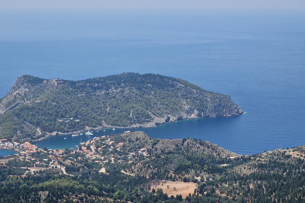
A Kefalonia island tour drives across the largest of the Ionian Islands, from the capital Argostoli to the villages of Assos and Fiskardo, the beach of Myrtos, the caves of Melissani and Drogarati, the fir forest of Mount Ainos and the Robola vineyards. This post covers what a Kefalonia island tour includes, Argostoli, the villages, the beaches, the caves, Mount Ainos, the wine and food, and the best season. It is one of the Greek island tours on Greece VIP.
Each section ends with a Kefalonia island tour that can be booked online.
What does a Kefalonia island tour include?
A Kefalonia island tour includes the capital Argostoli, the villages of the north and east, the beaches, the caves, the slopes of Mount Ainos and the wineries of the island. A bus, a jeep or a private car links the stops by road.
No other Ionian island covers as much ground as Kefalonia, which ranks sixth in size among the islands of Greece. The land is rugged and mountainous, and plains cover less than 15 percent of the island. Mount Ainos is the highest peak, at 1,628 metres, and the Paliki mountains stand to the west-northwest. A Kefalonia island tour therefore works around ranges, not across a plain.
The island lies in the Ionian Sea, west of the Greek mainland. The British built the first larger roads in the 19th century, and since 1995 almost all streets that link villages and beaches carry asphalt. The EO50 national road runs from Argostoli to Sami, and a Kefalonia island tour by bus, jeep or car follows these roads.
- Capital: Argostoli holds one-third of the island’s inhabitants.
- Villages: Assos and Fiskardo lie in the north.
- Mountain: Fir trees cover the top of Mount Ainos.
Four main harbours serve the island, at Sami, Poros, Argostoli and Fiskardo, and boats for a Kefalonia boat tour leave from them. A Kefalonia island tour stays on land. Since 2019 the island has formed three municipalities, Argostoli, Lixouri and Sami, and the tour visits all three towns.


What does a Kefalonia island tour see in Argostoli?
A Kefalonia island tour sees the bay and harbour of Argostoli, the De Bosset Bridge, the street called Lithostroto, the Katavothres sinkholes and their water mill, the Lighthouse of Saint Theodoroi and a capital rebuilt after the 1953 Ionian earthquake.
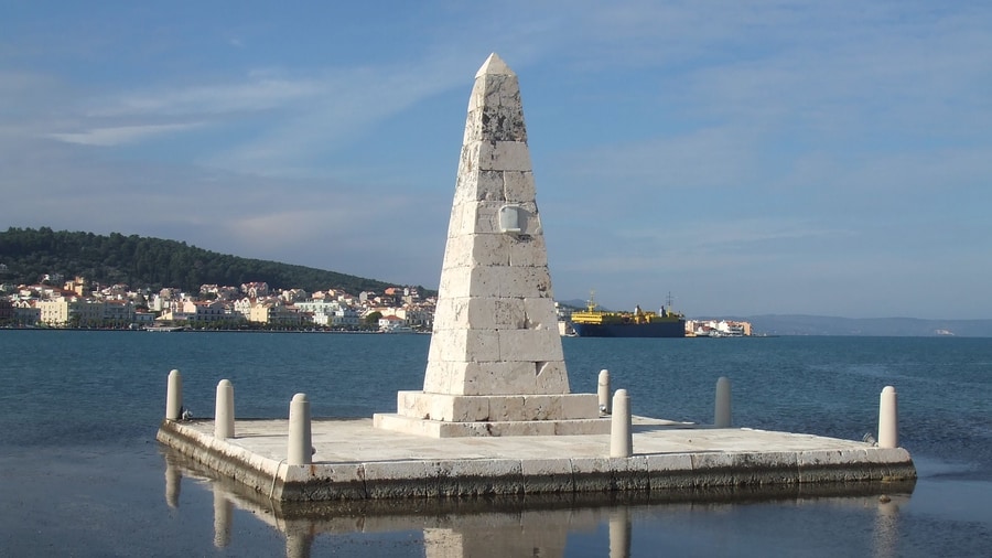
Argostoli became the capital in 1757, when the population left the old capital of Agios Georgios for the trade of the sheltered bay. Lithostroto, beside the Catholic Church, holds a small museum for the soldiers of the Acqui Division.
The De Bosset Bridge crosses the bay on 16 low stone arches and measures 689.9 metres, the longest stone bridge over the sea. Charles Philippe de Bosset, a Swiss-born officer, began the project, and the bridge dates from 1813. After the restoration from 2011 to 2013, the bridge carries only walkers, and a Kefalonia island tour crosses it on foot.
West of the town, along the coastal road, the Katavothres swallow holes take in sea water. The water flows under the island and comes out near Sami, and in 1835 its force drove a water mill. Further along stands the lighthouse of Saint Theodoroi, built in 1829 in the British period.
- Lagoon: The nature reserve of Koutavos Lagoon feeds loggerhead turtles.
- Lighthouse: Saint Theodoroi lighthouse is better known as Fanari.
- Bell Tower: The Bell Tower was rebuilt in 1985.
The 1953 Ionian earthquake struck on 12 August with a magnitude of 6.8 and raised the whole island by 60 centimetres. Argostoli suffered substantial damage, and the lighthouse fell. The new lighthouse follows the original plans, and the bridge shows its damage from the side. A Kefalonia island tour passes both.
Which villages does a Kefalonia island tour visit?
A Kefalonia island tour visits Assos and its Venetian castle, Fiskardo with its buildings that survived the 1953 earthquake, Sami on the east coast, Agia Efimia with its fishing harbour and Lixouri, the second-largest town on the island.
Venetian rule founded Assos on the west coast of Kefalonia, and from 1593 the village served as the administrative capital of the north. The army engineer Marino Gentilini built its castle, one of the largest in Greece. The lack of natural springs ended the plan, so the castle never worked as a fortress.
Fiskardo is the northernmost port of Kefalonia. The 1953 earthquake spared it, so the village kept its original architecture. Robert Guiscard, Duke of Apulia and Calabria, gave the village its name after he died at Atheras beach in 1085.
Sami lies on the central east coast. Ancient Same was one of four city-states of the island, and Rome took it in 189 BC after a long siege. Agia Efimia, a traditional fishing village, centres on a small harbour. The 1953 earthquake destroyed much of it, but a handful of original buildings survive.
- Assos: The village lies 36 kilometres north of Argostoli.
- Fiskardo: The poet Nikos Kavvadias lived in the village.
- Lixouri: The poet Andreas Laskaratos was born in the town.
Lixouri is the main town of the Paliki peninsula and the second-largest town of the island. Citizens of ancient Pale founded it, and a letter of 1534 to the Venetian Senate holds the oldest written mention of its name. The sea crossing from Argostoli covers 4 kilometres, but the road around the bay adds a 30 kilometre detour for a Kefalonia island tour by car.
Which beaches does a Kefalonia island tour stop at?
A Kefalonia island tour stops at Myrtos Beach in the north-west, and at Xi and Petani beaches on the Paliki peninsula. Myrtos has white cobblestones, Xi has soft red sand, Petani is a Blue Flag bay, and Antisamos Beach served as a film location.
Myrtos Beach belongs to the region of Pylaros, in the north-west of Kefalonia, where the mountains Agia Dynati and Kalon Oros frame it. Round white cobblestones form the beach, and marble makes up the sediment around it. The slope drops sharply at the shoreline, so strong waves grade the stones from cobbles to pebbles. A Kefalonia island tour reaches Myrtos by a road of about 2 km with hairpin turns from the village of Divarata.
Xi Beach lies in the south of the Paliki peninsula, in the district of Mantzavinata near Lixouri. The sand strip is 3.3 km long and up to 50 metres wide in places. Iron released as clay minerals break down gives the sand its red colour. A Kefalonia island tour finds the name in the shape of the beach, which resembles the Greek letter xi.
- Myrtos: The beach has been voted the best in Greece 12 times.
- Xi: The beach holds Blue Flag status and is a geosite of the Kefalonia Ithaka Geopark.
- Petani: No public transport serves the beach.
Petani Beach lies in the north-west of Paliki, in a curved bay at the foot of a steep road, and visitors compare it with a smaller Myrtos. Captain Corelli’s Mandolin was shot mainly in Argostoli, Sami and on Antisamos Beach. A Kefalonia island tour therefore meets cobbles, red sand and pebbles.
Which caves does a Kefalonia island tour visit?
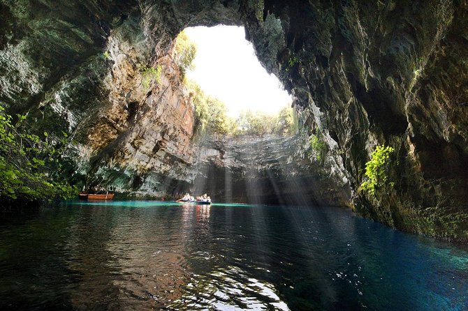
A Kefalonia island tour visits two caves near Sami, Melissani and Drogarati. Melissani is a cenote, a lake formed when a collapse of limestone bedrock exposed groundwater, and Drogarati lies near the fishing village of Karavomylos, which also stands close to Melissani.
Melissani is a cave and a cenote north-west of Sami. A collapse of limestone bedrock exposed the groundwater in 1953, and a lake now fills the cave. A vertical shaft gives access to the water table, where a small boat makes a round trip across the lake. Forest surrounds the opening. A Kefalonia island tour crosses this water by boat.
The water in Melissani is brackish, a mix of fresh water from inland and sea water that enters at depth. Sea water vanishes into sinkholes called katavothres near Argostoli, where a water mill turns, and it comes out again in the bay of Sami. The groundwater of the cave flows out at Fridi beach. Speleo-divers have explored huge karst conduits in this area.
- Myth: Greek mythology knew Melissani as the Cave of the Nymphs.
- Cenotes: The bay of Sami has further cenotes with deep shafts.
- Plants: Plants grow at the mouth of the cave.
Drogarati Cave stands near Chaliotata, a community of the municipal unit of Sami. Karavomylos, which lies 2 km west of Sami, has both Drogarati and Melissani close by. Together with Myrtos Beach, the two caves have helped to popularize the island, and a Kefalonia island tour counts them among the natural attractions of the east coast.
What does a Kefalonia island tour see on Mount Ainos?
A Kefalonia island tour sees Mount Ainos, the tallest mountain on the island at 1,628 metres, with the Greek fir forest of its national park, semi-wild ponies among the trees, and views that reach Zakynthos, Lefkada, Ithaca and the Peloponnese on clear days.
The bedrock of Mount Ainos is predominantly dolomite and limestone of Cretaceous age. A highway across the range links the south-western and eastern parts of the island. The Mt Ainos road runs from the north-west to a transmitter station near the summit, where television and cellphone relay towers stand. Between 3,000 and 4,000 people live on the slopes.
The Greek fir, Abies cephalonica, takes its species name from Cephallenia, the ancient name of the island. This evergreen conifer grows 25 to 35 metres tall and occurs between 900 and 1,700 metres. Its needle-like leaves carry two blue-white bands underneath. A Kefalonia island tour passes black pine too, since pine forests cover the slopes between 700 and 1,200 metres.
- Park: The national park dates from 1962 and is the smallest in Greece.
- Area: The park now covers more than 3,000 hectares.
- Sanctuary: Strabo places a sanctuary of Zeus Ainesios on the mountain.
On clear days the view from the summit takes in the north-west Peloponnese and Aetolia on the mainland, together with the islands of Zakynthos, Lefkada and Ithaca. Caves lie in the north of the range. A Kefalonia island tour that follows the Mt Ainos road therefore looks out over the mainland coast, the neighbouring Ionian Islands and the fir forest below.
Which wine and food does a Kefalonia island tour taste?
A Kefalonia island tour tastes Robola, the dry white wine of the island, and Kefalonian dishes such as sofigado, a rabbit stew, beside local olive oil. Stops near Omala and at the Monastery of Saint Gerasimos, patron saint of Kefalonia, add the setting.
Robola is a white Greek grape grown primarily on Cephalonia, and its vines root in limestone soils. The grape ripens early and gives high-acid wines. The wines are dry and medium bodied with a distinct lemon note, and wine expert Oz Clarke notes a flinty character. Wine and raisins were the oldest exports, so a Kefalonia island tour follows an old trade.
Omala occupies the south-central area of Kefalonia, and Valsamata, its seat, had 676 residents in 2021, and Epanochori and Michata are the next largest settlements. The monastery lies on a small plain surrounded by mountains, beneath Mount Ainos, over an older monastery from the year 1200. Gerasimos settled there in 1560 and was canonized in 1622.
- Robola: dry white wine with a lemon note.
- Sofigado: rabbit stew from the island of Kefalonia.
- Olive oil: green, low in acidity, from over one million trees.
Greek cuisine includes kreatopita, a meat pie wrapped in filo. Ithaca, the island of an Ithaca day trip, spans 96 square kilometres of rocky land, while Kefalonia spreads over 773 square kilometres, with plains on less than 15% of it. A Kefalonia island tour therefore tastes what the larger island grows.
When is the best season for a Kefalonia island tour?
A Kefalonia island tour works best in the dry summer, when days reach nearly 30 degrees Celsius and little to no rain falls, while winter is rainy, with snow on the mountain peaks. Saint Gerasimos is honored on August 16 and October 20.
Summer nights stay around 21 degrees Celsius. Winter is mild, with days at 14 to 15 degrees and nights at 8 to 9, and rain reaches 156 millimetres in the wettest months, with high humidity. A Kefalonia island tour in winter meets that rain, since the island belongs to Koppen class Csa, a Mediterranean type.
Coastal heatwaves stay mild in Greece, since the water is cooler than the land and a breeze blows in from the sea. Etesian winds blow until October and leave the Ionian Sea warmer than the Aegean. Mount Ainos reaches 1628 metres, above the 1,000 metre line where a warm-summer Mediterranean climate appears.
- Fire risk: a forest fire began on 18 July 2007.
- Snow: a snowstorm blanketed the island from 24 to 26 January 2006.
- Green cover: olive trees fill almost 55% of the island.
The feasts of Saint Gerasimos fall on August 16 and on October 20, the day of the translation of his relics. On both days the church passes the body of the saint over ill and sick persons at the monastery. A Kefalonia island tour in August meets the dry season.
What do travelers ask about a Kefalonia island tour?
A Kefalonia island tour runs across an island of 773 square kilometres, where asphalt roads link almost every village and beach, four main harbours serve ferries, one airport lies south of Argostoli, and Argostoli and Lixouri are the two largest towns.
Does a Kefalonia island tour need a car?
Buses run from Argostoli to Poros, Sami, Skala and Fiskardo, but the service is infrequent, and rural lines can run only twice a day. Car and motorcycle hire operate in Argostoli. Since 1995, asphalt has covered almost every street between villages and beaches.
Can a Kefalonia island tour cover the whole island?
Kefalonia measures 773 square kilometres. The main roads run from Argostoli to Sami, Poros and Fiskardo, and a road links Poros and Sami. Fiskardo is 32 km from Argostoli, to the north. Lixouri sits 4 km across the bay from Argostoli, yet the road between them is a 30 km detour.
Can a Kefalonia island tour combine with a boat trip?
Ferry ports make a combination possible. Ferries leave Fiskardo for Lefkada and for Frikes on the island of Ithaca. Sami has sailings to Patras and Ithaca, and Poros has routes to Kyllini. Argostoli, the largest port, has ferries to Zakynthos and to Lixouri.
Which story does a Kefalonia island tour recall?
The 2001 film Captain Corelli’s Mandolin was mainly shot in Argostoli, Sami and on Antisamos Beach. The novel behind it is believed to draw on the village of Farsa. Its love story is set before and after the massacre of the Acqui Division in World War II.
Which animals does a Kefalonia island tour meet?
The loggerhead turtle, Caretta caretta, nests on south-coast beaches and appears in Argostoli harbour, where walkers on De Bosset Bridge can watch it, and the Koutavos Lagoon is a feeding ground. Over 200 bird species have been spotted on the island, and the European pine marten lives there.
Featured photo: Tom Corser, CC BY-SA 3.0, via Wikimedia Commons.