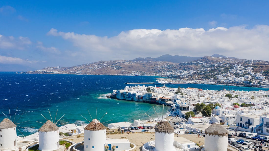
A Mykonos island tour shows the island by road and on foot, from the lanes of Chora, the windmills and Little Venice to the inland village of Ano Mera, the lighthouse on the north cape and the beaches of the south coast. This post covers what a Mykonos island tour includes, Mykonos Town, the windmills, Little Venice, Panagia Paraportiani, the old harbour, Ano Mera, the north of the island, the beaches, the museums, the local food, Delos, the history of the island and the best season. It is one of the island tours in Greece on Greece VIP.
Each section ends with a Mykonos island tour that can be booked online.
What does a Mykonos island tour include?
A Mykonos island tour is a land tour of a Cycladic island in the Aegean Sea. A licensed tour leader takes the group by road to Mykonos Town, the windmills, the villages, the beaches and the museums, and explains the history of each stop.
Mykonos belongs to the Cyclades, an archipelago in the Aegean Sea southeast of the Greek mainland. Its neighbours are Tinos, Syros, Paros and Naxos, and the island lies 150 kilometres east of Athens. It covers 85.5 square kilometres and rises to 341 metres. The 2021 census counted 10,704 inhabitants, and the largest town, Mykonos, stands on the west coast. A Mykonos island tour works on that small scale, with one principal town and ten villages.
The name Cyclades comes from the Greek word for surrounding, since the islands form a circle around Delos, a site sacred to ancient Greek religion. Naxos is the largest island of the group, and Syros has the biggest population. Milos and Santorini are volcanic, while the other islands are peaks of a submerged mountainous terrain. A Mykonos island tour crosses a granite island with no rivers, where reverse osmosis of sea water supplies 4,500 cubic metres a day.
A tour by road stays on land. A Mykonos island tour therefore differs from a Mykonos boat tour, which spends the day on the water and crosses the 2 kilometres of sea to Delos. The road tour reaches the town centre, the windmill hill, the villages and the museums. Taxis, buses and boats serve the island, and three main bus depots send routes to Ano Mera, to the New Port and to the southern beaches.
- Town: Mykonos Town carries the second name Chora, which means town in Greek.
- Windmills: The mills of Kato Mili overlook the sea from a hill in Chora.
- Villages: The island has ten villages, and a northern bus line serves Ano Mera, Elia and Kalafatis.
- Museums: The Archaeological Museum, the Aegean Maritime Museum and the Folklore Museum keep the records of the island.
A Mykonos island tour joins the facts of a single island: a granite rock without rivers, a main town on the west coast, a ring of Cycladic neighbours around Delos and a network of buses, taxis and boats. Each stop on land adds one layer to that picture, from the windmill hill above the sea to the display rooms of the museums in town.


What does a Mykonos island tour show in Mykonos Town?
A Mykonos island tour shows Mykonos Town, called Chora, as a west-coast town grown over a medieval castle site. The route takes in its Cycladic architecture, the Tria Pigadia wells, the Municipal Library and the square named after Manto Mavrogenous.
Chora is the Greek word for town, and Greece uses it for the principal town when an island and its main town share one name. Ios, Patmos and Kythira also call their main town Chora. Mykonos Town is the largest town on the island. Bus depots stand at the old port and at the town entrance, so a Mykonos island tour leaves from the town for the villages and the beaches.
The layout of Chora records its growth, and a Mykonos island tour reads it in the Kastro quarter. The quarter stands on the site of a medieval castle that the Ghisi family built in 1207. The castle was destroyed in the 16th century, and the town that spread in the 18th century built over the remnants. The island prospered as a trading centre until the end of the 18th century, which drew immigrants from nearby islands and regular pirate raids.
Mykonos is known for its traditional Cycladic architecture. Settlements of the Cyclades in the time of Minoan influence were small and tightly fortified, with attached houses grouped into blocks that paved lanes separated. Settlers from Anafi later built a neighbourhood in their traditional architecture at the foot of the Acropolis in Athens, and it still bears the name Anafiotika. On a Mykonos island tour, the lanes of Chora sit beside the windmills, the wells and the library, all within one town.
- Tria Pigadia: Three identical wells built in 1722 stand in a row in the middle of the town.
- Municipal Library: An 18th-century mansion on Ayia Kyriaki Square holds over 8,000 volumes.
- Manto Mavrogenous square: A statue of the national heroine stands in the middle of the square.
Chora combines a trading town of the 18th century, built over a medieval castle, with buildings made for everyday needs: wells dug into sand, a library in an old mansion and a square named for a heroine of the Greek Revolution. A Mykonos island tour finds each of them inside the town, on the west coast of the island.
Why does a Mykonos island tour stop at the windmills?
A Mykonos island tour stops at the windmills because Kato Mili, a row on a hill in Mykonos Town, gives a view of the whole town and part of the harbour. The mills milled wheat for the islanders and still define the skyline of Chora.
The windmills are a defining feature of the Mykonian landscape, dotted around the island, and the greater part stand in Chora. The mills can be seen from every point of the town and are the first thing seen on entering the harbour, since the hill overlooks it. The greater part face north, the direction of the island’s strongest winds. A Mykonos island tour stops on the hill because the whole town and part of the harbour are visible from it.
The Venetians built the greater share of the mills in the 16th century, and construction continued into the early 20th century. The mills were primarily used to mill wheat, and they were an important source of income for the inhabitants. Their use declined gradually until production stopped. Restored mills now serve as homes and as vaults for heritage documents of Mykonos. A Mykonos island tour therefore stops at buildings that fed the island.
A windmill is a machine that uses the force of wind on sails to mill grain. The sails turn a horizontal windshaft, and gears carry that motion to the millstones. In a tower mill, only the cap turns into the wind, and around parts of the Mediterranean builders fixed the caps in place because the wind direction varied little. On a Mykonos island tour the mills appear round and white, with a pointed roof and very small windows, a type found on almost all the Cyclades islands.
- Number: Mykonos has 16 windmills, and seven stand on the landmark hill in Chora.
- Sails: A majority of windmills have four sails, while earlier mills with more sails are found in Greece.
- Museum: One of the windmills has been transformed into a museum.
A Mykonos island tour stops at the windmills because three facts meet on one hill: a clear view of the town and the harbour, a row of mills that the Venetians built to mill flour, and a building type found on almost all the Cyclades islands. The hill shows how a Cycladic island once ground its grain, and the capped mills still face the northern wind.
What does a Mykonos island tour show in Little Venice?
A Mykonos island tour shows Little Venice, a waterfront row of fishing houses whose balconies hang above the water. Rich merchants and sea captains owned the houses, the first built in the mid-18th century, and their basement doors fed a rumour of piracy.
Little Venice stands on the waterfront of Mykonos town, the west-coast town that is also called Chora. Fishing houses form rows along the shore, and their balconies hang over the sea. The first of them was built in the mid-18th century, while Mykonos still prospered as a trading centre, so a Mykonos island tour meets the quarter as a record of that sea trade.
Pirates attacked Mykonos and other islands of the Cyclades. When the Greek Revolution began in 1821, Manto Mavrogenous, of Mykonian origin, equipped and manned two ships at her own expense to pursue them. On 22 October 1822 the Mykonians repulsed Ottoman Turks who had landed on the island, under her leadership. A Mykonos island tour passes the central square of the town, which bears her name.
Sailing and merchant activity lifted the economy of Mykonos, but it declined again in the late 19th century. The opening of the Corinth Canal in 1904 and the First World War deepened the decline. Mykonians left to find work in mainland Greece and abroad, especially in the United States. The first houses of Little Venice date from the earlier years of prosperity, which a Mykonos island tour recalls.
- Basement doors: Little doors in the basements opened onto the sea and onto storage areas below ground.
- Conversions: Houses now work as bars, cafes, little shops and galleries.
- Sunset: People gather on the waterfront to watch the sunset, and artists paint the coast.
Little Venice took shape under Ottoman rule, which lasted on Mykonos from 1537 to 1830. The Ottomans, under the Kapudan Pasha, imposed a system of self-governance made up of one governor and a council of syndics. When the castle of Tinos fell in 1718, the last Venetians withdrew from the region. A Mykonos island tour therefore sees a quarter from the era of local self-governance.
Why does a Mykonos island tour visit Panagia Paraportiani?
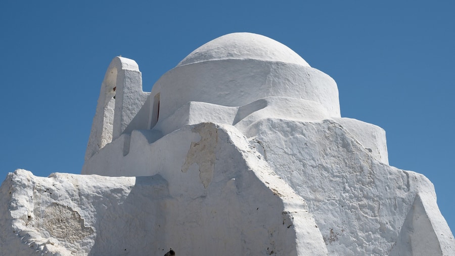
A Mykonos island tour visits Panagia Paraportiani because one whitewashed building in the Kastro neighbourhood of Chora joins five separate churches. Four churches at ground level form the base of a fifth church, and the work lasted from 1425 into the 17th century.
Paraportiani is a Greek name that points to a side gate. The church stood next to the door of the old castle, and the church itself had its entrance in the gate at the side of the Kastro. In the 16th century the castle was destroyed, and in the 18th century, as Chora grew, new buildings covered its remnants. A Mykonos island tour reaches the church through that rebuilt quarter.
The Ghisi family built the castle in 1207 and controlled the island then, so a Mykonos island tour of Kastro meets the Latin lords of Mykonos. Andrea Ghisi, the first Lord of Tinos and Mykonos, took part that year in the expedition that Marco Sanudo organised to conquer the Greek islands. He and his brother Geremia received five islands together. After the brothers divided them, Andrea obtained Tinos and Mykonos, which stayed outside the Duchy of the Archipelago.
Work on the church started in 1425, after direct Venetian rule over Mykonos began in 1390. In 1537 the admiral Hayreddin Barbarossa attacked the island, and Mykonos stayed in the Ottoman Empire until 1830 under the Turkish name Mukene. The church was finished in the 17th century, so the building spans the Venetian and Ottoman periods, and a Mykonos island tour sees both in one place.
- Dedications: The four lower churches carry the names of Saint Anastasia, the Saints Anargyroi, Saint Sozon and Saint Eustathios.
- Build time: Construction began in the 15th century and ended in the 17th century, so it took around 200 years.
- Fame: Its architectural quirkiness places the church among the best-photographed places in the world.
The Ghisi family kept Mykonos through a long dispute with Venice. On 11 August 1243 the Great Council of Venice condemned the brothers Andrea and Geremia Ghisi to confiscation of their property over the island of Andros, and Andrea was later exiled from Venice. By 19 March 1277 his son Bartholomew was lord of Tinos and Mykonos. A Mykonos island tour to Panagia Paraportiani thus reaches the Kastro of these lords.
What does a Mykonos island tour show at the old harbour?
A Mykonos island tour shows the old harbour of Mykonos town, where the pelican Petros, official mascot of the island, stays on the waterfront. In the same harbour, British and French warships fought the Battle of Mykonos in 1794.
Petros was a great white pelican. In 1958 a local fisherman found the wounded bird off the coast of Mykonos, and the locals nursed it back to health. It stayed on the island with their support, and they gave it the name Petros as a joke. Petros became the official mascot of Mykonos and an old celebrity of the town waterfront, which a Mykonos island tour reaches.
A car hit and killed Petros in December 1985. Three new pelicans then took up residence around the main town, and one of them received the name Petros as an honour. The islanders elected a successor to carry on the legacy of the first bird, and the name continues today. Petros has therefore served as the official mascot of Mykonos for over 60 years.
Seen on a Mykonos island tour, Petros belongs to the species Pelecanus onocrotalus, the great white pelican. The species measures 140 to 180 cm in length and has a wingspan of 226 to 360 cm, a pink and yellow bill and a pale-yellow pouch. It feeds mainly on fish and scoops them up with the pouch. In the Mediterranean basin the species breeds in only two colonies, in Turkey and northern Greece.
A Mykonos island tour to the harbour recalls the Battle of Mykonos, fought there on 17 June 1794. The 50-gun British ship HMS Romney was escorting a convoy when Captain William Paget found the 40-gun French frigate Sibylle at anchor with three French merchant ships. The French commodore placed Sibylle between the British guns and the town, which belonged to the neutral Ottoman Empire. Paget turned Romney so that its broadside faced away from the town, and Sibylle surrendered.
- Other names: The great white pelican is also called the eastern white pelican or the rosy pelican.
- Daily food: A great white pelican needs 0.9 to 1.4 kg of fish every day.
- Aftermath: Paget seized Sibylle and the three merchant ships, and the convoy reached Smyrna on 22 June.
Mykonos has an abundance of churches because the islanders were required, for a long time, to put a church on their land before putting up a house. At the old port, a bus depot runs to Tourlos, the New Port, and to Agios Stefanos. Small boats serve the beaches of the island, and tour boats sail regularly to Delos. A Mykonos island tour passes this seafront on the west coast.
What does a Mykonos island tour show in Ano Mera?
A Mykonos island tour shows Ano Mera, a village seven kilometres from Mykonos Town, and the monastery of Panagia Tourliani, the main monastery of the island. Its gilded wood-carved altarpiece in the Baroque style, the iconostasis, covers all three aisles of the church.
Ano Mera is one of the ten villages of Mykonos. The monastery of Panagia Tourliani stands there and carries the name of the patron saint of the island. It is dedicated to the Dormition of Theotokos. A Mykonos island tour by road reaches a monastery founded in 1542 on the site of a church of the Entrances of Panagia. The hieromonk Ignatios Basoula renovated it between 1757 and 1767 and gave it its present form.
According to tradition, fugitive monks of the Archontissa of Paros sought asylum on Mykonos and took refuge in the small church of Panagia in the upper part of the island, where the nun Tourli served. A second version ties the name to a miraculous icon of the Virgin Mary found in the sea off Tourlos. The icon is considered the work of Luke the Evangelist and belongs to the Holy Metropolis of Syros. A Mykonos island tour to the monastery therefore meets a name with two origins.
The catholicon, the monastery church, is a three-aisled cruciform Byzantine church with a dome and a towering marble spire. Florentine artists designed and built the gilded altarpiece in 1775. This iconostasis is 10.20 metres long, so the carving spans the whole width of the church. The iconographer Ioannis from Corfu made its icons. A Mykonos island tour that stops inside sees Baroque woodwork set against a Byzantine plan.
- Aisles: The central aisle honours the Dormition of Theotokos, the left aisle the Nativity of the Theotokos and the right aisle Saint Ignatius the Bearer.
- Church museum: The exhibits include icons, gold-embroidered epitaphs and the first bells of the monastery.
- Early 20th century: The monastery worked as a nursing home and later as an orphanage.
The monastery also sets the calendar of Ano Mera. A big festival takes place on 15 August, and the main feast, the Apodosis of the Dormition of Theotokos, falls on 23 August. Plots of monastery land were given away free for a kindergarten, a primary school, a square and a spiritual centre. A Mykonos island tour to Ano Mera therefore shows a village square and a school that grew from monastery land.
Which landmarks does a Mykonos island tour show in the north?
A Mykonos island tour shows the Armenistis lighthouse, a working light at Fanari, the north coast at Ftelia, where a Neolithic settlement lies by the beach, and an interior of granite that is very rocky and eroded by strong winds.
The Armenistis Lighthouse takes its place name from Fanari, the Greek word for lantern. Chora lies 6.5 km away, and the light is fully functioning. The tower bears witness to the sailing past of Mykonos, an island nicknamed the Island of the Winds for its very strong winds. A Mykonos island tour on the northern road therefore ends at a lighthouse that still works.
A Mykonos island tour on the north coast reaches Ftelia, an archaeological site on a beach. The Neolithic settlement there was discovered in 1992 and excavated from 1995 onwards. It belongs to the Saliagos culture of the early Final Neolithic, and the 14C method dated it to 5000 to 4500 BC. Archaeologists found wall foundations, pottery, stone tools, traces of metal processing and 19 stone figurines, of which 13 represent people and 6 represent animals.
Inland, a Mykonos island tour crosses a granite island with very rocky terrain. Mykonos has no rivers, only seasonal streams, and two of them were converted into reservoirs. Reverse osmosis of sea water supplies 4,500 cubic metres of water daily. Clay and baryte, a mineral used as a lubricant in oil drilling, were mined on the eastern side of the island until the late 1900s. The walls at Ftelia were largely built from rubble of the local granite, with flat stones for the foundations.
- Wind: Ftelia lies on the northern side, where a strong wind almost always blows, and windsurfers use the beach.
- Residents: Around 150 to 200 people lived in the settlement.
- Gold: A circular gold object from its first phase is the earliest securely dated gold object of the Aegean.
Mykonos measures 85.5 square kilometres in area, and its highest point reaches 341 metres. A Mykonos island tour in the north therefore stays inside one small area, yet it passes a working lighthouse, a Neolithic coast and a granite landscape. Ftelia ranks ahead of Saliagos as the leading known settlement of the Late Neolithic in the Cyclades. The sea level stood 10 m lower then, so the settlement lay on a relatively fertile coastal plain.
Which beaches does a Mykonos island tour reach by road?
A Mykonos island tour reaches the south-coast beaches by road, because a regular bus line runs from the town entrance to Psarou, Plati Gialos, Ornos, Agios Yannis, Paraga and Paradise Beach. Elia lies on a northern route, and Agios Stefanos sits next to the new harbour.
Taxis, buses and boats all serve the island, and three main bus depots organise the road routes. The northern depot, above the old port, runs regular service to Ano Mera, Elia and Kalafatis. Just below it, at the old port, a second depot serves Tourlos and Agios Stefanos. The third depot, in the south, feeds the beach line. A Mykonos island tour by road therefore starts from whichever depot faces the chosen shore.
Psarrou counts as a beach and as a village, 4 km from Mykonos town and close to Platys Gialos. The village had 106 residents in 2021. Platys Gialos is a village of Mykonos as well, and a second village of the same name lies on Sifnos. A Mykonos island tour in this part of the south coast therefore meets two neighbouring villages that each carry a beach.
A Mykonos island tour to Agios Stefanos reaches a sandy beach next to Tourlos, the new harbour of Mykonos, 3.5 km from the town. It draws a large number of tourists each summer because facilities stand close to the sand. Sunbeds, umbrellas and water sports are available there, hotels also offer accommodation, and restaurants and cafes stand on the beach. Taxis, private vehicles and the regular bus reach it from Mykonos town.
- Villages: Ornos, Platys Gialos, Psarrou, Agios Stefanos and Ftelia all appear among the ten villages of the island.
- Northern line: Elia shares its bus service with Ano Mera and Kalafatis.
- Old-port line: Tourlos and Agios Stefanos have a depot of their own.
Mykonos-Manto Mavrogenous Airport lies 4 kilometres from the town and serves international flights in summer. An estimate puts the number of visitors at 1.5 million or more each year, against 10,704 inhabitants at the 2021 census. Psarrou in the south and Agios Stefanos in the north stand at 4 km and 3.5 km from Chora, so a Mykonos island tour by road reaches a beach on either side of the town.
Which museums does a Mykonos island tour visit?
A Mykonos island tour visits the Archaeological Museum of Mykonos, the Aegean Maritime Museum and the Folklore Museum, three collections of island finds, ships and homes. Lena’s House and the Agricultural Museum, set inside a windmill, add a house museum and a farm collection.
The Archaeological Museum of Mykonos keeps the Mykonos vase, a large storage jar called a pithos, dated to about 675 BC. It is one of the earliest objects to show the Trojan Horse. A local inhabitant found the jar on the island with human bones inside, and the vase was produced on Tinos. A Mykonos island tour links this jar to the legend of Troy.
The neck of the jar shows the horse ringed by Greek warriors, with more warriors in its portholes. Three lines of panels called metopes sit beneath it, and the lower part of the vase is blank. On the main body, warriors without shields attack women and children, and no Trojan warriors appear. On a Mykonos island tour, the scene presents the sack of Troy as the slaughter of the defenceless.
The Aegean Maritime Museum was founded by the Mykonian George M. Drakopoulos, who received the Athens Academy Award for it. A Mykonos island tour reaches the first museum in Greece to restore living historical exhibits so that they work as originally designed and built. Two of them, the ships Thalis o Milesios of 1909 and Evangelistria of 1940, lie in Palaio Faliro, Athens, not on Mykonos.
Lena’s House is a traditional Mykonian residence of the 19th century that belonged to a wealthy shipping family. Its original furniture is still preserved, and the house now operates as a museum. The Agricultural Museum, also called the Bonis Mill, shows old tools and machinery inside one of the windmills. It stands above the main town in Ano Myloi, which means Upper Windmills.
- Pottery: The Archaeological Museum holds Cycladic ceramic pottery of the 9th to 8th century BC.
- Coins: The Aegean Maritime Museum shows coins with nautical scenes.
- Sculpture: The Folklore Museum displays marble sculptures beside household items.
Each museum covers a different part of island life: early pottery, merchant ships of the Aegean, the home of a shipping family and the tools of farming. A Mykonos island tour that stops at them adds dated history to the views of the town. The vase, the ships and the house each give a Mykonos island tour an object to stand beside.
What local food does a Mykonos island tour taste?
A Mykonos island tour tastes kopanisti cheese, louza cured pork and amygdalota almond cookies, three specialities listed for the island of Mykonos. The same list also names lazarakia spice breads, melopita, baklava, kremmydopita, omeletta and an appetizer called ksinotira.
Kopanisti takes its name from a Greek word for something that has been beaten, which describes its preparation. The cheese ages in wide-necked containers until abundant microbial flora develops, and kneading then mixes that flora through the mass. Makers repeat the kneading three or four times before the ripening ends, and they use cow’s, sheep’s or goat’s milk, or a mixture of them.
Milk is cooked with yeast until it thickens, and red chili peppers and salt are added. The cheese is wrapped in cotton cloth under a stone to press out liquid and ages in earthenware containers. On a Mykonos island tour, kopanisti appears in mostra, a dish of dry bread with the cheese, chopped tomatoes and olive oil. Islanders also serve it as a meze with ouzo.
Louza is preserved pork loin of the northern Cyclades islands of Mykonos, Syros, Andros and Tinos, and the list of Mykonos specialities likens it to the Cypriot lountza. It belongs to the family of cured pork tenderloin, where makers salt or brine the meat and then dry-cure or smoke it. The names of these cuts come from the Latin lumbus, meaning loin. A Mykonos island tour tastes one of them in louza.
Amygdalota are almond cookies linked with the Cyclades. They contain no coconut, yet they are sometimes called Greek macaroons. Cooks shape them like pears or balls, small enough to eat in one bite, sweeten them with honey and flavour them with orange flower water or rose water. Lazarakia are small sweet spice breads shaped like a man in a shroud with cloves for eyes, made on Lazarus Saturday. A Mykonos island tour tastes both.
- Cheese: Kopanisti Mykonou is the cheese on the island’s list of specialities.
- Spread: A spread of the same name mixes feta, grilled red sweet peppers, olive oil and garlic.
- Bread: Lazarakia contain no dairy products or eggs, so makers brush them with olive oil.
The island’s list rests on dairy, pork, almonds and bread, and each item carries a method or a custom: cheese kneaded in rounds and served with ouzo, cured pork, almond cookies of the Cyclades and Lenten spice bread. A Mykonos island tour that tastes them learns the island through its kitchens as well as its streets.
Can a Mykonos island tour include Delos?
A Mykonos island tour can include Delos only as a short mention, because the ruins lie on a separate island that tour boats reach from Mykonos regularly. Delos lies within the municipality of Mykonos, but a full visit to its archaeological site is a separate crossing.
A Mykonos island tour covers sites on the island of Mykonos itself, so Delos stays across the water as a neighbour. Delos is a small island near Mykonos, and local government places it inside the municipality of Mykonos. A short mention on a Mykonos island tour sets the island in context, but a full visit to the site belongs to a dedicated Delos tour, which lands on the ruins.
A Mykonos island tour that mentions Delos can add that its ruins record more than the classical centuries. Roman baths, coins, an aqueduct, houses, churches, basilicas and a monastery date from the first to the sixth centuries AD. Wine presses found among the ruins of the ancient city suggest that the people of that period grew grapes, and pottery shows that wine and oil still arrived from regional centres.
Inscriptions on Delos point to communities from the eastern Mediterranean. Two marble stelae record gifts by Cretan donors to a house of prayer, and the community names itself Israelites on Delos who make offerings to hallowed Argarizein, a reference to Mount Gerizim. The Delos Synagogue, built between 150 and 128 BCE, was found in 1912 by a team led by André Plassart, though its identification as a synagogue is no longer definitive.
- Crossing: Tour boats go regularly from Mykonos to the nearby island of Delos.
- Municipality: Delos is administratively part of the municipality of Mykonos.
- Listing: Delos sits on the World Heritage List, where UNESCO called its archaeological site exceptional.
- Inscriptions: Delos yielded inscriptions that honour Herod the Great and his son Herod Antipas.
A Mykonos island tour and a Delos visit answer different questions. The first explains Mykonos on land, from its town to its museums, while the second explains a sacred island of ruins, from Roman baths to Hellenistic inscriptions. Both islands sit in one municipality, and tour boats, not roads, cross the water between them.
What history does a Mykonos island tour tell?
A Mykonos island tour tells how a rocky Cycladic island passed from a myth of giants slain by Heracles to Venetian rule, then to the Ottomans, then to the Greek Revolution of 1821 under Manto Mavrogenous, and finally to the rise of international tourism.
Myth makes Mykonos the setting of the Gigantomachy, the war of Zeus against the giants. Heracles lured the invincible giants away from Mount Olympus and killed them, and the large rocks that a Mykonos island tour passes are said to be their petrified bodies. The ancient island was poor, with limited agricultural resources. After Alexander the Great died, it belonged to the League of the Islanders in the Hellenistic period, then to the Romans, and then to the Byzantine Empire.
Andrea Ghisi took Mykonos in 1204, after Constantinople fell during the Fourth Crusade. The Catalans ravaged the island at the end of the 13th century, and direct Venetian rule began in 1390. In 1537 Hayreddin Barbarossa, the admiral of Suleiman the Magnificent, attacked, and an Ottoman fleet settled on the island. Ottoman rule lasted until 1830, and the Turkish name of the island was Mukene.
Manto Mavrogenous, born in Trieste in 1796, came to Mykonos when the revolution began. She equipped two ships at her own expense and chased the pirates that attacked the Cyclades. On 22 October 1822 the Mykonians repulsed the Ottoman Turks who had landed, under her leadership. She also equipped 150 men for the Peloponnese. The central square of the town bears her name and holds a larger-than-life bust of her.
- Tinos: The last Venetians withdrew from the region when the castle of Tinos fell to the Ottomans in 1718.
- Harbour: British and French ships fought the Battle of Mykonos in the main harbour in June 1794.
- Occupation: In September 1944 a Greek Sacred Squadron commando raid inflicted casualties on the German garrison.
The island economy declined in the late 19th century, especially after the Corinth Canal opened in 1904. Mykonians left to find work on the Greek mainland and abroad, especially in the United States. Tourism took over later, helped by the French School of Archaeology, which began work on Delos in 1873. Jet-set visitors arrived in the 1960s. A Mykonos island tour therefore covers a place whose economy turned from sailing and merchant activity to tourism.
When is the best season for a Mykonos island tour?
A Mykonos island tour suits the dry months from April to September, after the rains of October to March have ended. The meltemi north wind runs from late spring until mid-September, leaving April free of it, while summer brings the wind and the peak of visitors.
Temperatures on Mykonos sit on two levels. The average daily high is 27.0 °C in summer and around 15 °C in winter, while the average night is over 24 °C in summer and 11 °C in winter. Rainfall is low, because the Pindus mountains dry out the westerly winds, so the National Observatory of Athens places the island in the hot semi-arid class. The wet season runs from October until March.
Dry and strong, the meltemi is the north wind of the Aegean Sea, and between late spring and mid-September it dominates the weather of the whole basin. On a summer Mykonos island tour the wind peaks in the afternoon and drops at night, yet a spell can run for days without a break. It springs up under clear skies with no warning and its force can climb to 7 or 8 on the Beaufort scale.
Visitors reach the island by air and by sea. High-speed vessels call every day from Athens and the nearby islands, and the airport handles international flights during summer. Mykonos ranks second among summer destinations in Greece, with an estimated 1.5 million visitors a year at least and room for about 50,000 visitors every night. A winter Mykonos island tour falls outside that summer schedule.
- Spring: The rains end after March, and the meltemi starts in late spring, so April falls between them.
- Autumn: The meltemi ends in mid-September, and the rains return in October.
- Winter: Mild, wet winter weather comes with sunny days even in mid-winter.
- Ferries: Yachts and inter-island ferries that cannot sail in force 7 or 8 winds wait in port.
The etesians have a long record. The word comes from the Greek etos, meaning year, because the winds follow a yearly pattern, and writers have described them since ancient times. Philip II of Macedon planned his military operations around the etesian season, because ships from the south sailed north only very slowly while the winds blew. Italian mal tempo, meaning bad weather, is the suspected source of the modern Greek name meltemi.
What do travelers ask about a Mykonos island tour?
A Mykonos island tour covers a Cycladic island that lies in the Aegean Sea, 150 kilometres east of Athens, between Tinos, Syros, Paros and Naxos. The island rises to a high point of 341 metres and has no rivers.
How far apart are the stops on a Mykonos island tour?
A Mykonos island tour covers short distances. The island measures 85.5 square kilometres, Armenistis Lighthouse stands in Fanari 6.5 km from Chora, and the airport lies 4 km southeast of the town. The municipality, with Delos, Rineia and the uninhabited islets, adds up to 105.183 square kilometres.
Can a Mykonos island tour run without a car?
A Mykonos island tour can run without a private car, since taxis, buses and boats are available. Buses leave the northern depot for Ano Mera, Elia and Kalafatis, the old port for Tourlos and Agios Stefanos, and the entrance of the town, called Fabrika, for the southern beaches.
Can a Mykonos island tour combine with Delos?
A Mykonos island tour combines with Delos because the island lies only 2 km away. Tour boats go regularly to Delos. Delos is part of the municipality of Mykonos along with Rineia, and French archaeologists started excavating it in 1873. The Archaeological Museum of Mykonos holds finds from the neighbouring island of Rhenia.
What is the terrain like on a Mykonos island tour?
A Mykonos island tour crosses rocky granite ground. Strong winds have eroded large areas of it. Seasonal streams replace rivers, and two of them were turned into reservoirs. Reverse osmosis of sea water produces 4,500 cubic metres of water daily for the needs of residents and visitors.
What does Chora mean on a Mykonos island tour?
A Mykonos island tour uses the name Chora for the main town, the Greek word for town. Greece follows this practice when an island shares its name with its principal town. Mykonos Town stands on the west coast, and the island has ten villages in all.
Why does a Mykonos island tour find an abundance of churches?
A Mykonos island tour finds an abundance of churches, because a long-standing rule required a church on the land before any house stood on it. Bishop Leandros Zanthakis renovated the only Catholic church on the island in 1677, after it was built in 1668. A fire in 1991 damaged part of it, and it reopened in October 1997.
Featured photo: dronepicr, CC BY 2.0, via Wikimedia Commons.