
An Elafonisi day trip crosses western Crete to Elafonisi, a small islet off the south-west coast with a shallow lagoon and a beach of pale pink sand. This post covers what an Elafonisi day trip includes, the pink sand, the protected nature, the history, the Chrysoskalitissa Monastery, the villages and gorges on the road and the best season. It is one of the best tours in Greece on Greece VIP.
Each section ends with an Elafonisi day trip that can be booked online.
What does an Elafonisi day trip cover?
An Elafonisi day trip covers a protected island close to the south-west corner of Crete, the beach facing it and the shallow water between the two, which can be crossed on foot in fine weather. The island is part of the Chania regional unit.
The name Elafonisi comes from the Greek Ελαφονήσι, which means “Deer Island”. The island lies near the south-western corner of Crete, the largest island in Greece and the fifth largest in the Mediterranean Sea. The Libyan Sea spreads along the south of Crete. Elafonisi ranks among the popular tourist attractions of Crete, together with the islands of Chrysi, Gramvousa and Spinalonga, and an Elafonisi day trip brings visitors to its shore.
In administrative terms, Elafonisi is part of Crete. It falls within the municipality of Kissamos, in the Chania regional unit. Chania, one of four regional units on Crete, takes in the westernmost quarter of the island. The municipality of Kissamos took its present shape in the local government reform of 2011, when three former municipalities, Kissamos, Inachori and Mythimna, merged. It covers 341.018 square kilometres.
Tourists come to Elafonisi for its white sand beach and warm, shallow water. Shallow water separates the island from the beach facing it on Crete, and in fine weather people can wade across on foot. The island itself is a protected nature reserve, known for its pink sand beaches, and the Cave of Aghios Mamas lies on it. An Elafonisi day trip links three parts: a beach on Crete, a walk through shallow sea and a protected island.
- Region: An Elafonisi day trip stays within the Region of Crete, the southernmost of the 13 top-level administrative units of Greece.
- Regional unit: Chania has seven municipalities and also takes in Gavdos, the southernmost island of Europe.
- Coast: An Elafonisi day trip heads to western Crete, which the Mediterranean Sea and the Libyan Sea bound to the west and south.
Three parts make up the ground of an Elafonisi day trip: the beach on Crete, the shallow water that leads across and the protected island beyond it. All three lie at the south-western corner of Crete, inside the municipality of Kissamos and the Chania regional unit. Each part has its own features, from the pink sand to the cave and the memorials.


Why is the sand pink on an Elafonisi day trip?
An Elafonisi day trip shows sand tinted pink by pigmented microorganisms. These organisms live in a symbiotic relationship with native seaweed. Tides and waves leave deposits of them along the shore, and those deposits give the beaches of the island their pink colour.
Elafonisi is known for a white sand beach, yet its pink sand beaches owe their tint to living matter. The pigmented microorganisms behind the colour live alongside the native seaweed, and tidal movement and wave action lay them down on the shore. Colour saturation in the sand today stands at only around 10% of its early twentieth-century level. An Elafonisi day trip therefore shows a paler pink than visitors saw a century ago.
Pink sand also exists far from an Elafonisi day trip: beaches in Bermuda and the Bahamas owe their colour to tiny organisms called foraminifera. On Bermuda, a strong red colonial foraminifer named Homotrema rubrum grows on coral rubble in tropical waters. The surf grinds it into sand-sized pieces that give Bermuda beaches a pink tint. At Horseshoe Bay in Bermuda, tiny red foraminifera mix with very fine white sand. On Harbour Island in the Bahamas, a species of foraminifera with a reddish-pink shell supplies the hue.
The name foraminifera means “hole bearers” in Latin, and each one is a single-celled organism. Their outer shell, known as a test, is commonly made of calcium carbonate, and the organisms rarely pass 1 mm in size. Science recognises over 50,000 species, living and fossil. Antonie van Leeuwenhoek described their tests in 1700 and compared them to minute cockles. Alcide d’Orbigny gave the group its name, foraminifères, in his 1826 work.
- Delivery: On an Elafonisi day trip, tides and waves are the forces that bring the coloured deposits ashore.
- Shell material: Foraminifera build tests from protein, sediment particles, calcite, aragonite or, in one case, silica.
- Algae partners: Endosymbiotic algae in foraminifera include green, red and golden algae, diatoms and dinoflagellates.
The pink colour on an Elafonisi day trip is therefore a product of the sea: microorganisms, seaweed, tides and waves. At Elafonisi the named agents are pigmented microorganisms living with native seaweed, while the pink beaches of Bermuda and Harbour Island take their tint from foraminifera. The colour has thinned since the early twentieth century, which ties the pink sand on an Elafonisi day trip to the protection rules of the island.
How is nature protected on an Elafonisi day trip?
An Elafonisi day trip enters a protected nature reserve. The Greek government declared the area a reserve and banned removal of its pink sand, after a period when tourists took the sand as souvenirs. Elafonisi also appears among the environmentally protected areas of Crete.
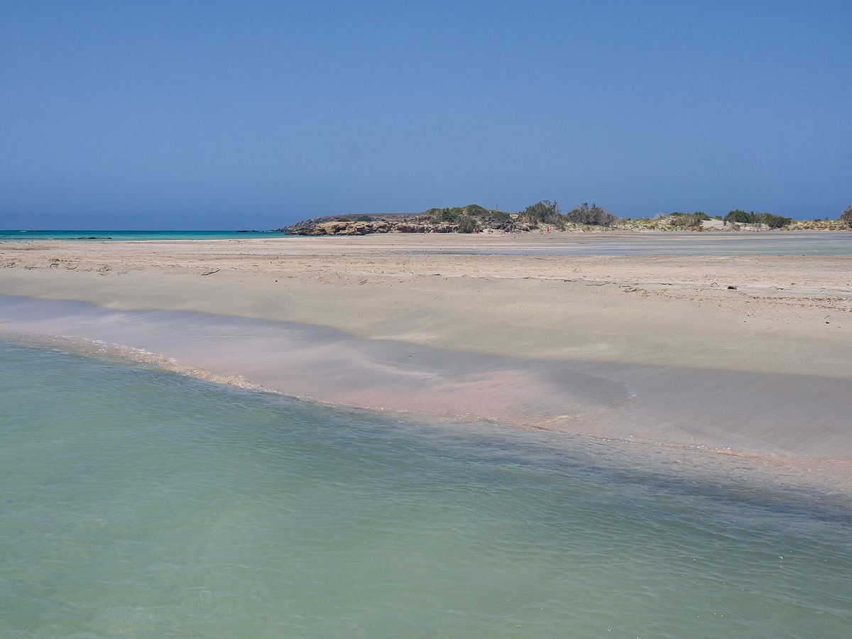
Elafonisi holds the status of a protected nature reserve. Before this status, its pink sands were a frequent target for tourists who carried sand home as souvenirs. The Greek government then declared the area a nature reserve and prohibited the removal of the sand. On an Elafonisi day trip, the ban means the pink sand stays on the beach, together with the deposits of microorganisms that give it colour.
An Elafonisi day trip leads to one of the environmentally protected areas of Crete, on its south-western coast. The same group covers the palm forest of Vai in eastern Crete and the Dionysades, both in the municipality of Sitia in Lasithi. Vai forms the largest natural palm forest in Europe. Samaria Gorge holds the status of a World Biosphere Reserve, while Richtis Gorge has protection for the diversity of its landscape.
Crete lies isolated from mainland Europe, Asia and Africa, and the diversity of its plants and animals reflects this isolation. The island supports 1,600 plant species, and about 10% of them are endemic. Among its animals, the Cretan wall lizard, Podarcis cretensis, is endemic to Crete and its satellite islands. At Elafonisi, the shore itself holds pigmented microorganisms and native seaweed. An Elafonisi day trip passes through this living system.
- EU network: Natura 2000 links nature protection areas across the European Union, on land and at sea.
- Legal base: Its sites fall under the Birds Directive of 1979 and the Habitats Directive, which followed in 1992.
- Scale: In 2022 the network covered more than 18% of EU land and more than 7% of its marine area.
Protection on an Elafonisi day trip rests on one clear rule: the pink sand stays on the beach. Colour saturation already stands at around a tenth of its early twentieth-century level, and the ban guards the deposits that remain. Elafonisi stands in the same group of protected areas of Crete as the palm forest of Vai and the Dionysades.
What is the history behind an Elafonisi day trip?
An Elafonisi day trip reaches an island with two memorials. A plaque at its highest point recalls the killing of hundreds of Greeks by Ottoman soldiers on 18 April 1824, and a large wooden cross recalls the wreck of the steamer Imperatrix on 22 February 1907.
The first memorial on an Elafonisi day trip belongs to the Greek War of Independence. By the spring of 1824, a joint Turkish-Egyptian force under Hussein Bey had pushed Cretan resistance back to a handful of mountain enclaves. Forty armed men fled the advancing Ottoman troops and hid on Elafonisi together with women, children and old people. They waited for a ship to the Ionian Islands, which between 1815 and 1864 formed a Greek state under British protection.
Ottoman soldiers set up camp on the beach opposite the island. A horse from their camp waded through the shallow water to Elafonisi and gave away the hiding place. On Easter Sunday, 18 April 1824, the soldiers killed hundreds of Greeks, chiefly women and children. Accounts put the total on the island at between 640 and 850 people. The survivors were sold into slavery in Egypt, and a plaque at the highest point of the island recalls the event.
The second memorial on an Elafonisi day trip dates from 22 February 1907, when the Imperatrix, a passenger steamer of Österreichischer Lloyd, was wrecked at the island. Österreichischer Lloyd was the largest Austro-Hungarian shipping company and had its base at Trieste. In strong northwest winds, a lifeboat heading for the shore lost 38 people, and all of them were buried on Elafonisi. The wreck still rests on the seabed in front of the island’s cliffs.
- Lighthouse: The wreck led to a lighthouse on an island hilltop, which occupying German troops destroyed in the Second World War.
- Union: The London Protocol of 1830 left Crete outside the new Greek state, and Crete joined Greece in December 1913.
- Occupation: The Battle of Crete took place in 1941, and Nazi Germany then occupied the island.
The plaque and the cross give an Elafonisi day trip two fixed points in history. The first event turned on the shallow water, which let a horse reach the hiding place in 1824. The second left a wreck in front of the cliffs in 1907 and led to a lighthouse on a hilltop. Visitors on an Elafonisi day trip can wade through the same shallow water today in fine weather.
Which monastery does an Elafonisi day trip pass?
An Elafonisi day trip passes the Chrysoskalitissa Monastery, a 17th-century Greek Orthodox monastery on the southwest coast of Crete. It stands on rocks 35 metres above sea level, looks out over the Libyan Sea, and belongs to the Inachori district of the Kissamos municipality.
Local tradition ties the name of the monastery to its stairway. Ninety steps lead up to the main building, and one of them is said to be golden. The Greek word for gold is chrysos, the root of the first part of the name Chrysoskalitissa. The same tradition holds that only devout Christians can see the golden step. Travelers on an Elafonisi day trip reach the main building by this same flight of ninety steps.
The monastery stands on a promontory on the southwest coast of the island and faces the Libyan Sea. In local government terms, the site falls within Inachori, a municipal unit of Kissamos. Chrysoskalitissa is also listed as one of the settlements of Inachori, the hilly district that draws visitors on an Elafonisi day trip to the beach. Ancient Cisamus, on the site of today’s Kissamos, became a Christian bishopric, and its see remains a residential see of the Eastern Orthodox Church of Crete.
Small coves lie close to the monastery promontory. In earlier times they offered a landing point for sailors who came to Crete from the west. Archaeologists have found remains of late Neolithic and Early Minoan settlements on this coast. The Minoan civilization was a Bronze Age culture centred on Crete, and it grew out of the local Neolithic culture around 3100 BC. A stop here on an Elafonisi day trip adds this prehistoric layer to a visit to the beach.
- Greek name: In Greek the monastery is called Μονή Χρυσοσκαλιτίσσης.
- Dedication: The house honours the Holy Trinity (Agia Triada) and the Dormition of the Virgin Mary (Koimisis tis Theotokou).
- Feast day: The Dormition is a Great Feast of the Eastern Orthodox Church, observed on 15 August.
The monastery joins a 17th-century Orthodox house to a coast with prehistoric roots. The legend of the golden step explains its name, the two dedications point to the Holy Trinity and the Dormition, and the coves below once gave sailors from the west a place to land. For an Elafonisi day trip, these layers of faith and early settlement sit on the same southwest coast as the beach.
Which villages and gorges does an Elafonisi day trip cross?
An Elafonisi day trip crosses the far west of Crete. From Chania the A90 runs west to Kissamos, a port town, and the last stretch enters Inachori, a hilly group of villages that includes Elos, Kefali and Vathi, with chestnut woods, caves and gorges nearby.
The first leg of an Elafonisi day trip from Chania follows the A90, the Northern Road Axis of Crete, which runs about 310 km from Kissamos in the west to Sitia in the east. Its Kissamos to Chania stretch forms part of European route E65, and Kissamos port lies 41 km west of Chania. The town is also known as Kastelli, after the Venetian castle that once stood there, and today it serves as a port and fishing harbour with a ferry link to the Peloponnese via Kythira.
In the southwest, an Elafonisi day trip enters Inachori, whose name means “nine villages”. This shady, hilly area is rugged and remote, and it is known for its chestnuts. Elos served as the seat of the former municipality, and the other settlements include Perivolia, Kefali, Vathi, Kampos, Strovles, Vlatos, Amygdalokefali and Chrysoskalitissa. Today Inachori is a municipal unit of Kissamos, with an area of 136.716 km².
Caves and gorges mark the hills that an Elafonisi day trip crosses. The Cave of Aghia Sophia lies near the village of Topolia, in the former Chania prefecture. Within the municipality of Kissamos, a gorge runs between the mountain village of Sirikari and the ancient acropolis of Polyrrhenia, with a moderate path through it. Sirikari stands at 512 m, 17 km south of Kissamos, beside a chestnut forest that is typical of the region.
- Trees: Trees on Crete grow taller in the west of the island, where water is more abundant, and the chestnut is among the common trees.
- Kissamos villages: The municipal unit of Kissamos includes Sfinari, Koukounaras, Polirinia, Platanos, Lousakia, Sirikari, Kallergiania and Kalathena.
- Museum: A town museum in Kissamos fills the old Venetian governor’s palace, and local finds include mosaics from the Roman city of Kisamos.
- Borders: The municipality that hosts an Elafonisi day trip meets Platanias to the east and Kantanos-Selino to the south.
From Kissamos onward, the road section of an Elafonisi day trip stays within one municipality. It links a port town with Venetian and Roman layers to Inachori, the nine-village district known for chestnuts, and then to the southwest coast. The Cave of Aghia Sophia near Topolia and the gorge between Sirikari and Polyrrhenia add further landmarks to this western end of the island.
When is the best season for an Elafonisi day trip?
An Elafonisi day trip meets its clearest weather between April and October, when Chania sees clear skies on almost every day. June, July and August are the driest months there, with 2.0, 1.4 and 1.4 mm of rain.
Crete falls mainly within the hot-summer Mediterranean climate (Köppen Csa), and Chania shares this type, with sunny, dry summers and mild, rainy winters. Western Crete gets more rain than the eastern part of the island, and the Chania regional unit receives more precipitation than any other regional unit of Crete. On the mountains, snow falls commonly from November to April, while the low ground rarely sees it.
Climate records from the Chania Airport station at Souda for 1971–2000 show the pattern. Average highs rise from 19.9 °C in April to 29.0 °C in June and reach 30.5 °C in July. Rain drops to 2.0 mm in June and 1.4 mm in July and August, against 126.4 mm in January. July also brings 376.7 hours of sunshine, the highest monthly total at the station, which suits an Elafonisi day trip built around the beach.
Wind shapes the summer on the coast. The etesian winds, known as Meltemia, blow from the Aegean Sea and keep strong heat waves above 38 °C uncommon in Chania, while hot southern winds called Sirocco or Livas can bring heat and Saharan dust as early as March. Inachori, the district around Elafonisi, is known for the warm shallow waters at the beach, a draw for an Elafonisi day trip in the hot months.
- Spring: Western Crete draws visitors with spring flowers that linger in the mountains into late spring.
- Summer: For an Elafonisi day trip in July, the Souda station shows an average low of 21.4 °C and 0.2 rain days.
- Autumn: October averages a high of 23.4 °C, and among WMO stations Crete holds the European records for the highest temperatures in October and November.
- Winter: January averages a high of 14.0 °C and brings 17.0 rain days, while snow covers the White Mountains into spring.
The figures point an Elafonisi day trip toward June to September for dry, warm beach days, with April and October as cooler months under clear skies. From November to March, rain at Souda climbs above 80 mm a month, and western Crete gets more rain than the east, so the winter months suit a beach visit less.
What do travelers ask about an Elafonisi day trip?
An Elafonisi day trip reaches the Libyan Sea coast of southwestern Crete, in the same district as a monastery that lies about 72 km southwest of Chania. The same regional unit holds the Balos lagoon and the Samaria Gorge, which fits a separate tour on another day.
Which sea does an Elafonisi day trip reach?
The coast at the end of an Elafonisi day trip faces the Libyan Sea. The islet of Artemis, also called Prasonisi, sits in this sea south-east of Elafonisi. Ancient geographers used the name Libyan Sea for the part of the Mediterranean south of Crete, and this stretch now also goes by the name South Cretan Sea.
How far from Chania does an Elafonisi day trip go?
Chania, the capital of the regional unit, lies around 40 km from the west end of Crete, or about 52 km by road. An Elafonisi day trip goes further, to the southwest corner. In the same district as Elafonisi, the Chrysoskalitissa Monastery lies about 72 km southwest of Chania, which gives a measure of the distance.
Which lagoon in Chania can a traveler add after an Elafonisi day trip?
The Balos lagoon lies between Gramvousa island and the coast of north-western Crete, off the Gramvousa peninsula at the western side of Kissamos Bay. An islet in the lagoon forms part of Cape Tigani, a name meaning “frying pan” in Greek. Imeri Gramvousa holds the remains of a Venetian fort built between 1579 and 1584.
Can an Elafonisi day trip pair with a Samaria Gorge tour on another day?
Yes. The Samaria Gorge lies in southwest Crete, in the same Chania regional unit, so a Samaria Gorge tour fits a separate day. A national park since 1962, the gorge runs 16 km from 1,250 m at its northern entrance to the Libyan Sea at Agia Roumeli. At the Gates, the walls stand only four metres apart.
Featured photo: dronepicr, CC BY 2.0, via Wikimedia Commons.