A Skopelos boat trip sails around Skopelos in the Northern Sporades, a green island of pine forests and quiet coves, and across to Alonissos and the islets of the marine park. This post covers what a Skopelos boat trip includes, where the boats leave from, the chapel of Agios Ioannis on its rock, the coast and beaches, Alonissos, the National Marine Park, Skopelos town from the sea and the best season. It is one of the best tours in Greece on Greece VIP.
Each section ends with a Skopelos boat trip that can be booked online.
What does a Skopelos boat trip include?
A Skopelos boat trip covers the coast of a green Northern Sporades island, where Aleppo pine forest reaches cliffs that fall steeply into the sea. The routes run around Skopelos itself, across to Alonissos and its marine park, or aboard a private boat.
Skopelos is a Greek island in the western Aegean Sea. It belongs to the Northern Sporades, east of the Pelion peninsula and north of Euboea. The island covers 96 square kilometres. A Skiathos boat trip leaves from the neighbouring island to the west, while a Skopelos boat trip leaves from Skopelos itself, with Alonissos as the nearest inhabited island to the east.
Skopelos counts as one of the greenest islands in the Aegean Sea. Aleppo pine forests make up the chief vegetation, joined by Kermes oaks and olive groves. The island has the shape of a saxophone, with the neck pointing northwest. Cliffs fall steeply into the sea along the greatest part of the coast, so a Skopelos boat trip shows shoreline that roads and trails do not reach.
Three kinds of Skopelos boat trip exist. The first circles the island and stops at coves along its 67 kilometres of coast. The second crosses to Alonissos and the National Marine Park of Alonnissos-Northern Sporades, set up in 1992 to protect the Mediterranean monk seal. The third uses a private boat and follows a route chosen by its own group, so the order of the coves belongs to that group.
- Around the island: A circuit follows the saxophone-shaped coast past pine forest.
- Alonissos: The crossing east reaches the marine park set up in 1992.
- Private boat: One group chooses its own route.
A Skopelos boat trip therefore pairs a short list of routes with a long coastline. The island measures 96 square kilometres and has 67 kilometres of shore, two mountains above 500 metres and pine forest that reaches the water. The later sections take each part of that coast in turn, from the ports to the chapel.


Where does a Skopelos boat trip leave from?
A Skopelos boat trip leaves from three ports: Skopelos town harbour on the northern coast, the port of Glossa at Loutraki in the north-west, and Agnontas on the south coast. The town harbour is the main port of the island.
Skopelos shares its name with its main port and municipal centre. The town lies in a bay on the northern coast and is noted for its architectural heritage. Hydrofoils and ferryboats from the mainland ports of Volos and Agios Konstantinos serve the island, with connections on to Alonissos and Skiathos. A Skopelos boat trip from the town harbour begins on the same shore.
Glossa is the second largest settlement on the island. The village stands on the north-western tip, between 200 and 300 metres above the sea, just above Loutraki harbour. The Greek word glossa means tongue, and the community includes the villages of Atheato and Loutraki. A Skopelos boat trip from the north-west therefore starts at the water below the village, not in the village itself.
Agnontas is a beach village with a small port on the south coast. Hagnon of Peparethus, an athlete from Skopelos, won at the Ancient Olympic Games in 568 BC, and the harbour is said to carry his name because his ship landed there on his return. Agnontas also works as the alternative port for ferries and hydrofoils when bad weather closes the main port.
- Skopelos town: The main port lies in a bay on the northern coast.
- Glossa and Loutraki: The harbour below Glossa serves the north-western tip.
- Agnontas: The alternative port in bad weather.
Three starting points give a Skopelos boat trip three different coasts. The town harbour opens to the north, Loutraki to the north-west and Agnontas to the south. Northerly gales sometimes close the main port, while the bays of Staphylos, Agnontas and Panormos offer better protection, so the choice of port sets the first stretch of the route.
Why does a Skopelos boat trip stop at Agios Ioannis Kastri?
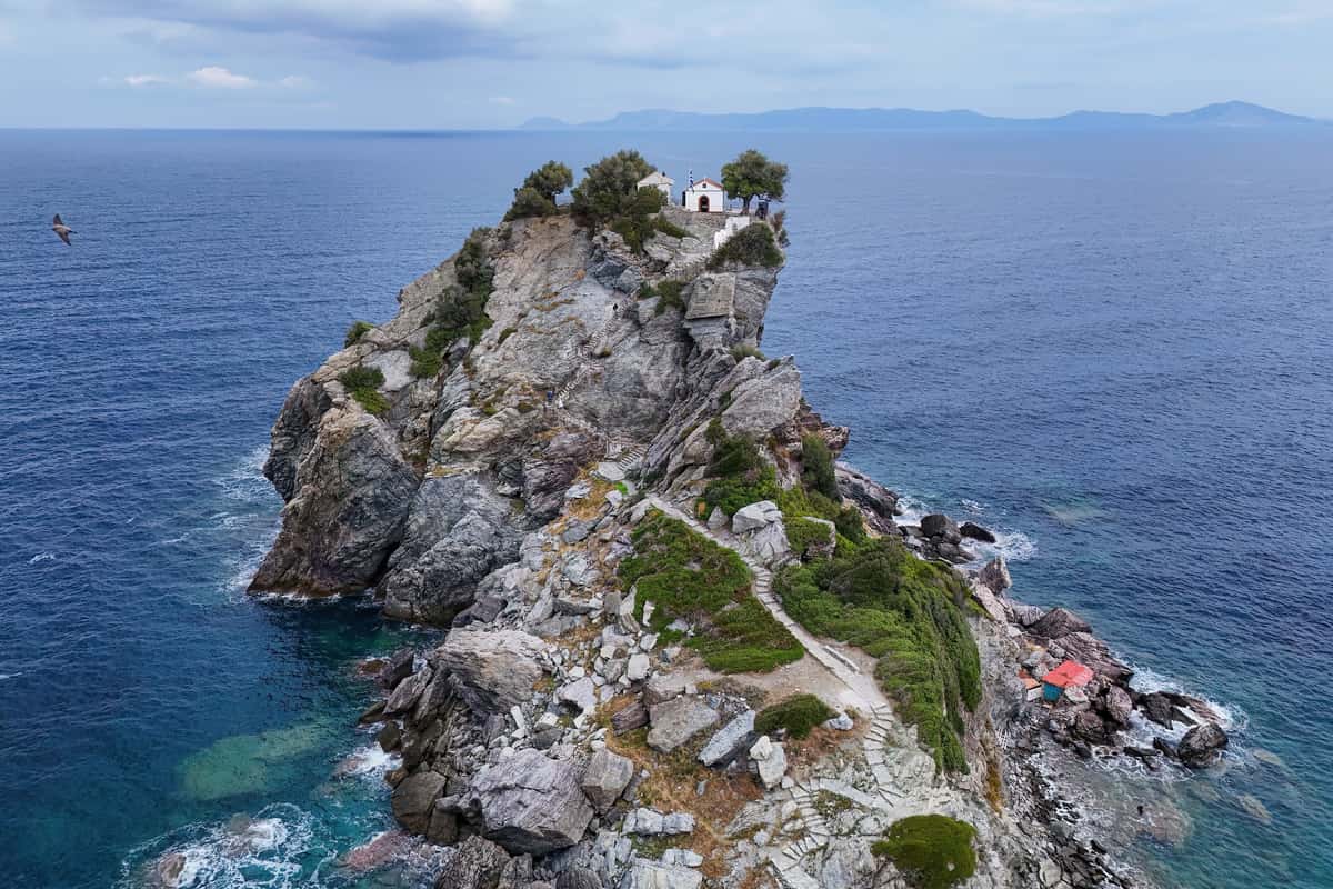
A Skopelos boat trip stops at the chapel of Agios Ioannis near Glossa because the wedding procession of the film Mamma Mia! was shot there. The film was made on Skopelos in 2007, and the chapel stands on the north-western side of the island.
Mamma Mia! tells its story on the fictional Greek island of Kalokairi, a Greek word for summer. The real filming took place mainly on Skopelos, and the island stands in for Kalokairi on screen. On Skopelos, Kastani beach on the southwest coast was the main location site. The producers built a beach bar and a jetty there, then removed both after production wrapped.
The wedding procession was filmed at the Agios Ioannis Chapel near Glossa. In the plot, the bridal party and the guests enter a chapel before the wedding begins. Glossa lists the chapel of Agios Ioannis among its churches, and a Skopelos boat trip that stops there stays on the Glossa side of the coast, away from the beach at Kastani.
Tourism carries the economy of Skopelos. The filming in September 2007 raised hopes of more visitors, and the 2008 release put the island on a cinema screen. The island holds more than 360 churches and chapels, and the Agios Ioannis chapel is the one that appears in the film, which gives a Skopelos boat trip a clear reason to include it.
- Film: Mamma Mia! premiered in London on 30 June 2008.
- Chapel: The wedding procession scene belongs to Agios Ioannis.
- Beach: Kastani, on the southwest coast, was the main set location.
The stop at the chapel ties the island coastline to a film shot there in 2007. The procession scene belongs to Agios Ioannis near Glossa, the main location to Kastani, and the story to the invented island of Kalokairi. Two of those names mark real places on Skopelos, so the stop works as a reference point for a Skopelos boat trip.
What does a Skopelos boat trip see along the coast?
A Skopelos boat trip sees steep cliffs, pine slopes and sheltered bays, with the coves and beaches of Kastani, Milia, Panormos, Limnonari, Velanio and Stafylos. The coast runs for 67 km, and mountain terrain closes off the larger share of it from walkers.
Skopelos has the outline of a saxophone, with the neck pointing northwest and the bell lying to the east. Cliffs drop steeply into the sea along the greater part of the shoreline, and natural harbours are scarce. A Skopelos boat trip follows this edge from the water, where the rock walls, the pine forest above them and the small bays show together.
Kastani, Milia, Panormos and Limnonari are beaches that the island’s roads or trails reach on land. Panormos lies on the west coast, in a bay that gives shelter. The writer Michael Carroll arrived at Panormos Bay and built a house there, as he tells in his book Gates of the Wind. A Skopelos boat trip passes these bays from the water.
The Bibliotheca of Apollodorus, a mythological compendium from the 1st or 2nd century AD, names Staphylus as a son of Dionysus and Ariadne. His name means a cluster of grapes in Ancient Greek, and Skopelos legend makes him the founder of the island. In 1936 excavations in the area of Staphylos and Velanio uncovered a royal tomb from the era of Mycenaean Greece.
- Birds: Great cormorants, herring gulls and yellow-legged gulls are seen along the coast.
- Shelter: Staphylos and Panormos shelter better than the main port, which northerly gales can close.
- Plains: Level ground lies at Staphylos, Ditropon and Panormos.
The coast of Skopelos holds six named places on this route: Kastani, Milia, Panormos, Limnonari, Velanio and Stafylos. A Skopelos boat trip shows them from the water as parts of one shoreline of cliffs and pines. The same shore holds a Mycenaean royal tomb. From here the route turns east toward Alonissos.
Why does a Skopelos boat trip continue to Alonissos?
A Skopelos boat trip continues to Alonissos because the island lies 3 km east of Skopelos as the third member of the Northern Sporades. It adds the port of Patitiri, the Old Village in the south and pine trees that are abundant across the island.
Alonissos is a Greek island in the Aegean Sea. It measures 20 km from southwest to northeast, with an area of 64 square kilometres. The island was called Liadromia until the 19th century and was renamed in 1838. The 2021 census counted 3,138 inhabitants in the municipality, and only 33 lived on the smaller islands, so a Skopelos boat trip reaches a small community.
Patitiri, the main port of Alonissos, lies in the southeast. Ferry, catamaran and hydrofoil services link it with Volos, Agios Konstantinos and Thessaloniki on the mainland, and with Skiathos, Skopelos and Skyros. After the earthquake of 1965, inhabitants returned to Patitiri in large numbers instead of the old village. A Skopelos boat trip that calls at Patitiri reaches the main harbour.
The village of Alonnisos stands in the southern part of the island. It is known locally as Chora, and road signs call it The Old Village. Until 1965 the stone-walled houses stood close together around the capital, a small fortress that protected against enemies and pirates. The earthquake of 9 March 1965 damaged the village heavily, and its rebuilt houses now serve tourism.
- Products: Almonds, grapes, figs and olives are the main farm products.
- Beaches: The beaches around the island consist of pebbles.
- Early name: Ancient Greeks called the island Icus, and Cnossians colonised it.
The Alonissos stage gives the route a second island, with the main port of Patitiri, the restored Old Village and pine trees that are abundant on the island. The national marine park includes the island itself, so a Skopelos boat trip to Alonissos enters protected waters. The next section covers that park.
What does a Skopelos boat trip see in the National Marine Park of Alonissos?
A Skopelos boat trip sees limestone slopes, pine-covered islands and open sea in the National Marine Park of Alonissos Northern Sporades. The islands of Peristera, Kyra Panagia and Gioura belong to it, and its waters shelter the Mediterranean monk seal and dolphins.
The National Marine Park of Alonnisos Northern Sporades was founded by presidential decree in 1992. It was the first park of its kind in Greece, and at about 2,260 square kilometres it is the largest marine protected area in Europe. A Skopelos boat trip enters a park that takes in the island of Alonnisos, six smaller islands and 22 uninhabited islets and outcrops.
The six smaller islands in the park are Peristera, Kyra Panagia, Gioura, Psathoura, Piperi and Skantzoura. Coniferous forest and macchia cover the islands, and underwater beds of Posidonia seagrass stay in good condition. A Skopelos boat trip sees steep rocky slopes running down to the sea along this group. On Gioura lives a wild goat that ranks among the rare species of the park.
The Mediterranean monk seal is the species the park protects, and the Northern Sporades are one of its prime breeding areas. Caves in the limestone are an important part of its habitat, and pregnant seals use inaccessible undersea caves to give birth. The species is shy and sensitive to human disturbance. Dolphins share these waters, among them the common, striped and bottlenose dolphin.
- Zone B: Open to visitors across 678 square kilometres, except for free camping and fires.
- Zone A: Vessel approach and mooring are forbidden around Piperi, out to 3 nautical miles.
- Fish: About 300 species of fish live in the park area.
The marine park is the protected sea behind a Skopelos boat trip to the east. Islands with pine and macchia, limestone caves, seagrass beds and a wary monk seal define it, and dolphins share the water. The park rules keep vessels away from Piperi, while Zone B stays open to visitors.
What history lies behind a Skopelos boat trip?
A Skopelos boat trip follows the coast of ancient Peparethos, an island known across the Greek world for its wine. Minoans brought vines in the Late Bronze Age, and Byzantine, Venetian and Ottoman rulers followed in turn before the island joined the First Hellenic Republic in 1830.
In the Late Bronze Age the island carried the name Peparethos, and Minoans colonised it and introduced viticulture. Its wine reached the ancient Greek cities of the Mediterranean. In the play Philoctetes, first performed at the Festival of Dionysus in 409 BC, Sophocles sends a wine merchant astray on his way to Peparethos, rich in grapes and wine. A Skopelos boat trip today passes shores with that early fame.
Pliny the Elder, in his Natural History, repeats the view of the physician Apollodorus, who advised King Ptolemy on wines. Apollodorus preferred the Peparethian wine to the rest on his list, including the Leucadian and the Ambraciotic. He added that its name suffered because it was not thought fit to drink until it had been kept for six years. A Skopelos boat trip therefore follows a shore with a long place in the wine trade.
The city-state Chalcis in Euboea held the island for a time, from at least the 8th century BC. An earthquake struck Peparethus in 426 BCE, and Philip V of Macedon destroyed the city in 200 BCE to keep it from the Romans. Macedon and Rome held the island in turn, then the Byzantine Empire from 395 until 1204, the Latin Empire of Constantinople, and the Byzantines again from 1277. Venetian rule came after the Fall of Constantinople in 1453.
The Ottomans captured the Northern Sporades under Hayreddin Barbarossa in 1538, and Ottoman rule on Skopelos lasted until the Greek War of Independence. Skopelos then joined the First Hellenic Republic when the London Protocol confirmed its sovereignty on 3 February 1830. The island once had a wooden shipbuilding industry. Italy occupied it from June 1941 to September 1943, and Germany from September 1943 to October 1944. A Skopelos boat trip crosses waters that all these powers claimed.
- Peparethos: The ancient name of the island belongs to the wine trade.
- Minoans: The colonisers who introduced viticulture arrived in the Late Bronze Age.
- Philip V: The king of Macedon destroyed the ancient city in 200 BCE.
- Barbarossa: The Ottoman admiral took the Northern Sporades in 1538.
The history behind a Skopelos boat trip runs from Minoan vines and a play by Sophocles to an Ottoman admiral and a Greek republic. The wine of Peparethos carried the name of the island across the Mediterranean, and each power that held the island left a place in the record. A Skopelos boat trip passes the same shores that Macedon, Rome, Byzantium and Venice once ruled.
Which monasteries can a Skopelos boat trip see from the sea?
A Skopelos boat trip belongs to an island that holds the Monastery of Saint Riginos, named for its patron saint, and that rises to Mount Palouki, 546 metres high, in the southeast. Mountains dominate the western and eastern parts of the island.
Skopelos has a monastery that bears the name of its patron saint, the Monastery of Saint Riginos. The feast day of Riginos, 25 February, is a local holiday on the island. Christian tradition calls him a bishop who was tortured to death in 362 AD. Part of his remains lie in a local church. A Skopelos boat trip therefore covers an island whose patron saint has a monastery in his name.
Riginos belongs to the early days of Christianity on the island. Christianity was formalised on Skopelos by the appointment of Bishop Riginos in the 4th century. He was martyred in 362 AD, under the reign of the Emperor Julian the Apostate. The larger part of his relics rests in the Archangel Michael Trypiotis Church in Nicosia, Cyprus. The record for a Skopelos boat trip thus ties the monastery to a bishop of the 4th century.
The town and port of Skopelos sit in a bay on the northern coast. Mount Palouki, at 546 metres or 1,791 feet, stands in the southeast, and Mount Delphi, at 681 metres, stands in the centre. Between the high slopes of the west and the east, Palouki and Delphi form the high ground of the island that a Skopelos boat trip circles.
- Monastery: The Monastery of Saint Riginos carries the name of the island’s patron saint.
- Feast day: The feast of Riginos falls on 25 February, a holiday on the island.
- Mount Palouki: The mountain stands 546 metres high in the southeast.
- Mount Delphi: The mountain stands 681 metres high in the centre.
The named monastery of a Skopelos boat trip is the Monastery of Saint Riginos, which honours a bishop of the 4th century who was martyred in 362 AD. Palouki and Delphi supply the mountain backdrop, and the town sits in its northern bay. A Skopelos boat trip therefore joins one monastery name to the high ground of the island and to the story of its first bishop.
Which other Sporades islands lie around a Skopelos boat trip?
A Skopelos boat trip sails among the Northern Sporades, an archipelago of 24 islands along the east coast of Greece in the Aegean Sea. Four of them are permanently inhabited: Skiathos, Skopelos, Alonnisos and Skyros. The name Sporades means those scattered.
The Northern Sporades lie northeast of the island of Euboea, in the Aegean Sea. Modern geography recognises five different Sporades groups, among them the Saronic Islands, the Dodecanese and the Thracian Sporades. Since about 1960, however, the word refers mainly to this northern cluster, which is also called the Thessalian Sporades. A Skopelos boat trip therefore crosses the group that holds the name today.
The list of the Northern Sporades names ten islands: Skopelos, Alonnisos, Skiathos, Skyros, Kyra Panagia, Peristera, Gioura, Skantzoura, Piperi and Tsougria. Skiathos, Skopelos and Alonnisos form the Sporades regional unit, which the 2011 Kallikratis reform created from part of the former Magnesia Prefecture in Thessaly. The unit has three municipalities, one for each island. Alonnisos, the municipality in the east, already has its own section in this post, so a Skopelos boat trip needs no more detail on it here.
Skantzoura sits between the northern islands and Skyros. The island lies 18 kilometres southeast of Alonnisos, to which it belongs administratively, and 31 kilometres northwest of Skyros. It had no resident population in 2011, and it stands inside the Alonnisos Marine Park. The two distances place Skantzoura on the line between the northern three islands and Skyros, so the chain reaches far beyond one Skopelos boat trip.
Skyros is the southernmost inhabited island of the Sporades. At 209 square kilometres it is also the largest, and more than twice the area of Skopelos. About 3,000 people lived there in 2021. Skyros has its own capital, also called Skyros or Chora, and its main port is Linaria on the west coast. Administratively it belongs to the Euboea regional unit in Central Greece, not to the Sporades unit.
- Skantzoura names: The island was called Scandira, Skandeira or Scandila in ancient times.
- Skyros terrain: Forest covers the north of the island, while the south is bare and rocky.
- Kochila: The highest mountain of Skyros rises to 792 metres.
- Skyros municipality: The municipality covers a total area of 223.10 square kilometres.
The islands around a Skopelos boat trip form a compact archipelago with a clear order. Skiathos, Skopelos and Alonnisos make up the northern core, Skantzoura stands without residents to the south-east, and Skyros closes the chain as the southernmost inhabited island. A Skopelos boat trip stays within the core, while the wider group explains the name Sporades.
How do you reach the island for a Skopelos boat trip?
A Skopelos boat trip starts with a sea crossing, because Skopelos has no airport. Ferries and hydrofoils link the island with the mainland ports of Volos and Agios Konstantinos, and Skiathos, the neighbouring island, has an airport with scheduled and charter flights.
Volos is a coastal port city in Thessaly, about 170 kilometres north of Athens and 140 kilometres south of Thessaloniki. It stands at the innermost point of the Pagasetic Gulf, at the foot of Mount Pelion. The city is a major commercial port of mainland Greece, with ferry and hydrofoil links to Skiathos, Skopelos and Alonnisos. The port therefore serves as one mainland gate for a Skopelos boat trip.
The port of Volos lies on the ancient Thessalian settlement of Iolkos, where Greek myth says Jason built the Argo. The present harbour was founded in 1893 and ranks as the third-largest cargo port in Greece, after Piraeus and Thessaloniki. Links to the islands run mostly to the Sporades. Seaplane services also connect Volos with Skiathos, Skopelos and Alonnisos, which adds an air route to the sea links before a Skopelos boat trip.
Agios Konstantinos is a town in Phthiotida, also written Phthiotis. After the 2011 administrative reforms it became part of the municipality of Kamena Vourla, and it now ranks as a municipal unit with an area of 72.292 square kilometres. The town had 2,952 inhabitants in 2021. Its harbour has a regular ferry-boat connection to Skiathos, Skopelos and Alonnisos, so Agios Konstantinos is a second mainland port for a Skopelos boat trip.
Skiathos adds an air route to the picture. Skiathos Alexandros Papadiamantis Airport takes its name from a novelist who was a native of the island, and it first operated in 1972. Its runway measures 1,628 metres and is characterised as short and narrow. The airport stands 4.5 kilometres from Skiathos town. Hydrofoils and ferryboats serving Skopelos allow connections to and from Skiathos, which links the airport to a Skopelos boat trip by sea.
- Volos airport: The International Airport of Central Greece at Nea Anchialos links the city to international destinations.
- Skiathos terminals: Terminal 1 is the domestic terminal, and Terminal 2 handles international arrivals.
- Skiathos site: The airport stands on land reclaimed from the sea between Skiathos and the small island of Lazareta.
Every Skopelos boat trip therefore begins on the water. The mainland side offers the ports of Volos and Agios Konstantinos, each with ferry or hydrofoil links to the island chain, and the air side offers Skiathos, with an airport that sits one sea link away. The sources name the ports and the airports but leave timetables to the operators, so the exact crossing for a Skopelos boat trip needs a current schedule.
What does a Skopelos boat trip see of Skopelos town from the sea?
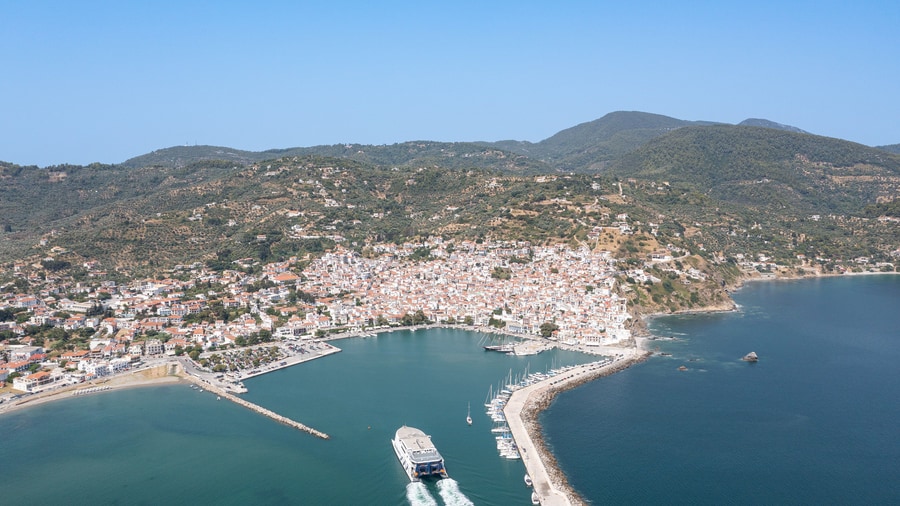
A Skopelos boat trip sees the main port of the island, set in a bay on the northern coast. From the water, the town shows its protected rooflines, the Kastro area with the oldest standing church, and the harbour front.
Skopelos town shares its name with the island and is also called Chora. Wikipedia notes the town for its architectural heritage. The island has a limited number of bays and natural harbours, and cliffs fall steeply into the sea along the greater part of the coast. A Skopelos boat trip therefore meets the town as a built-up point on a cliff-lined shore.
Seen from the sea, the town keeps a low skyline. A presidential decree signed in 1978 declared it a Traditional Settlement of Outstanding Beauty, and the building rules that followed cap new buildings at two stories. Roofs must slope and be ceramic or stone, while doors, windows and balconies must be wood. The code covers new construction and renovation inside the village.
The island holds more than 360 churches and chapels. The Kastro area holds the Basilica of Agios Athanasios, the oldest church still standing on the island, which dates from the 11th century. Kastro is Greek for castle. All but one of the churches follow the Greek Orthodox faith. The majority were privately built and stay closed except on the feast day of their saint.
- Ancient site: Peparethus, a member of the Delian League, stood where the town stands.
- Venetian years: Venice ruled the island from 1456 to 1538 and called it Scopelo.
- Harbour front: Ferries and hydrofoils serve the port, and a large parking area lines the waterfront.
The town in view from a Skopelos boat trip is a layered one. An ancient city stood on the site, Venice held the island for a period, a decree protects the skyline and the churches number more than 360. A Skopelos boat trip brings these facts together in a single view.
When is the best season for a Skopelos boat trip?
A Skopelos boat trip meets the etesians, the dry north winds of the Aegean, from late spring until mid-September. July and August bring the peak. Spring and autumn lie on either side of that wind season, and tourism on the island is greatest in summer.
Skopelos lies in the western Aegean, in the Northern Sporades east of the Pelion peninsula. Greece has a predominantly Mediterranean climate, and Wikipedia notes that Skopelos receives a frequent and steady northerly wind. The weather behind a Skopelos boat trip therefore rests on a north wind that returns each summer and is known in the Aegean as the etesian wind, or meltemi.
The etesians, or meltemia, form the strong, dry north wind system of the Aegean. The Climate of Greece article extends their season to October, with the highest frequency in July and August. In the northern Aegean they blow from the northeast to the north. Their effect is a cooler Aegean: temperatures and daily temperature swings stay below those of the Ionian Sea or mainland Greece.
Sailors face a risk from the etesians, which come up in clear weather without warning and are strongest in the afternoon. On Skopelos, the main port can sometimes be closed by northerly gales. A Skopelos boat trip in July or August therefore falls in the windiest part of the year, while spring and autumn sit on either side of that window.
- Wind window: The etesian season starts in late spring and peaks in July and August.
- Tourism peak: Tourism on Skopelos is greatest in the summer months.
- Year-round: Wikipedia calls the island a year-round retirement destination for Northern Europeans.
The best season for a Skopelos boat trip depends on how a traveler weighs the north wind against the crowds. Summer brings the sun, the peak of tourism and the peak of the etesians. Spring and autumn lie outside the main wind window and see less tourism. Each choice rests on a source.
What do travelers ask about a Skopelos boat trip?
A Skopelos boat trip raises five common questions: how the island differs from Skiathos, whether monk seals appear, where sheltered bays lie, where the Mamma Mia! chapel stands, and how travelers reach the island. Each answer rests on stated facts.
How does a Skopelos boat trip differ from a Skiathos boat trip?
Skiathos is the neighbour to the west and Alonnisos the neighbour to the east, so a Skopelos boat trip starts from the island between them. The island measures 96 square kilometres, a little larger than Mykonos, and its outline resembles a saxophone.
Can a Skopelos boat trip show monk seals?
The Northern Sporades are one of the prime breeding areas of the Mediterranean monk seal, and a marine park created in 1992 restricts human encroachment there. The species is shy and sensitive to disturbance, so a sighting on a Skopelos boat trip is possible but not certain.
Where does a Skopelos boat trip find sheltered bays?
The smaller bays of Staphylos, Agnondas and Panormos give better shelter from northerly gales, with Agnondas on the south coast and Panormos on the west. Roads and trails reach Limnonari and Milia beaches, but the greater part of the coast is inaccessible by land.
Where is the Mamma Mia! chapel for a Skopelos boat trip?
In Mamma Mia!, the wedding procession scene was shot at the Agios Ioannis Chapel close to Glossa. Glossa is the second largest settlement of the island, 25.4 kilometres from Skopelos town. Kastani beach on the southwest coast was the film’s main location site.
How do travelers reach the island before a Skopelos boat trip?
The island has no airport, because the application for one was denied, and only a heliport serves medical emergencies. Commuter hydrofoils and ferryboats run from Volos, Magnesia and Agios Konstantinos, with connections to Alonissos and Skiathos. In summer a ferry also links the island with Kymi.
Featured photo: Giles Laurent, CC BY-SA 4.0, via Wikimedia Commons.