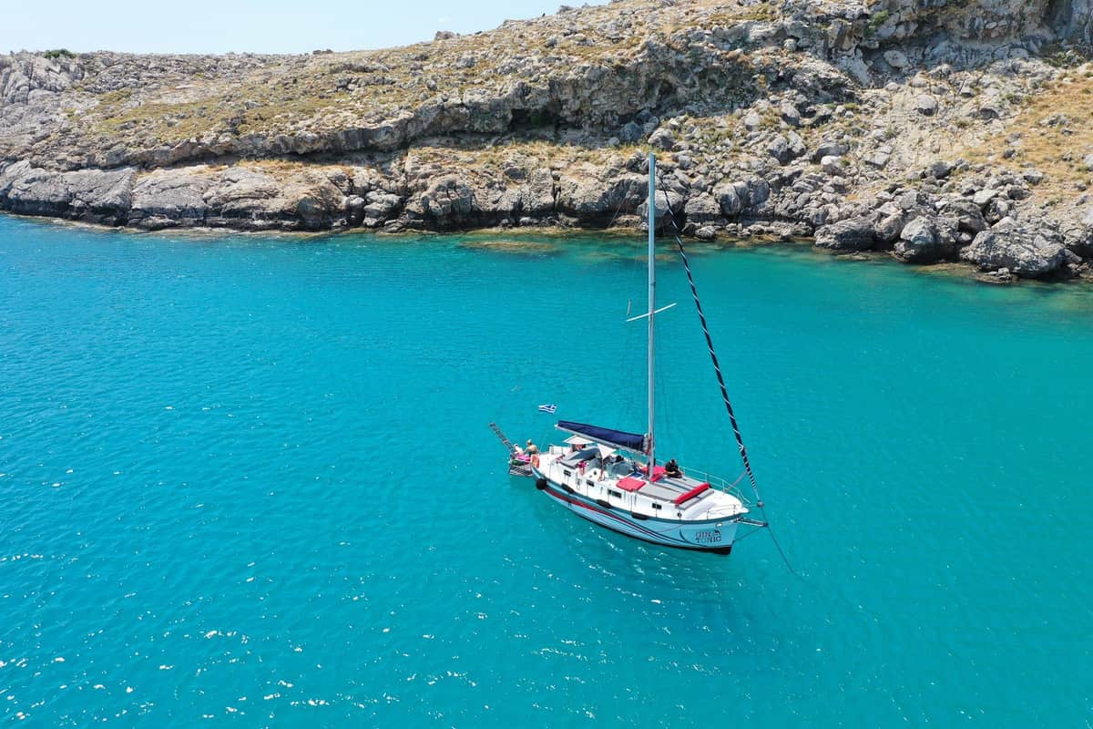
A Rhodes yacht cruise takes a small group out on a sailing or motor yacht along the coast of Rhodes. Cruises stop in clear bays for swims and sail past Lindos. It is one of the yacht charters in Greece on Greece VIP.
This post covers what a Rhodes yacht cruise includes, the marinas and the yachts. It also covers the bays, islands, Lindos from the sea, the winds and how sailors find their way. Safety, food and drink, the best season and common questions come last.
Each section ends with a Rhodes yacht cruise or a nearby sea tour that can be booked online.
What does a Rhodes yacht cruise include?
A Rhodes yacht cruise includes stops at anchor in quiet water. A long anchor line holds the yacht in place. Flags, sea miles and safety gear shape the day on board. An old sea law from Rhodes still echoes today.
At each swim stop of a Rhodes yacht cruise, an anchor holds the boat. The rode, made of rope, chain or both, joins the two. Its length against the water depth is the scope.
A good spot for a Rhodes yacht cruise is well protected, with good holding ground. It also needs depth at low tide and room to swing.
In moderate conditions, the rode runs to 4 times the depth. Rough weather calls for up to twice that. Water 8 m deep, under an anchor roller 1 m up, counts as 9 m. That depth needs 36 m of rode.
The plough anchor looks like a farm plough. Each copies a 1933 UK patent by the mathematician Geoffrey Ingram Taylor. It stows in a bow roller and is popular with cruising sailors.
The American Richard Danforth invented his anchor in the 1940s for landing craft. Peter Bruce from Scotland designed a claw-shaped anchor in the 1970s. Either can serve a Rhodes yacht cruise.
Flags follow their own rules on a Rhodes yacht cruise. A visiting boat flies a courtesy flag in foreign waters as a token of respect. It is the host country’s small maritime flag.
- Nautical mile: It equals exactly 1,852 metres, fixed in Monaco in 1929.
- Liferaft: It packs into a fibreglass canister and inflates from high-pressure gas.
- Shore power: Dock power lets a berthed boat switch off its engines.
The Lex Rhodia, the Rhodes sea code of about 800 BC, covered cargo thrown overboard. All who gained from lightening the ship shared that loss. Quotes from the lost code survive in the 6th-century Digest of Justinian.


Which marinas serve a Rhodes yacht cruise?
A Rhodes yacht cruise can set out from the Private Yacht Marina in Mandraki. A public port fund runs it. Visitors there can reach fuel supplies and food stores. Harbours on Symi, Halki, Tilos and Kastellorizo also take yachts.
The Municipal Port Fund of South Dodecanese is that public body. It runs the ports of Rhodes, Karpathos, Kasos, Tilos, Symi, Halki and Kastellorizo. The Mandraki Marina offices stand on Neoria Square.
The Tourist Port of Rhodes has an information desk. A kiosk checks tickets for passengers to Turkey. These harbours also feature on the page about a boat trip from Rhodes.
For a Rhodes yacht cruise, Kamiros Skala is a small port on the western coast. It has a waiting area, parking, cafés and shops nearby. Large cruise ships do not call there.
On Symi, the Gyalos waterfront runs for 622 meters. Ferries and large day-cruise ships use 90 meters of it, 7.00 meters deep. The rest serves yachts, recreational boats and fishing boats.
Panormitis Bay, also on Symi, has a C-shaped pier 70 meters long and 6.00 meters wide. Its usable depth is 5.00 meters. A Rhodes yacht cruise can moor there to visit the Monastery of Panormitis.
Halki’s harbour sits inside its bay, next to the main settlement. Its dock has a frontage of 50 meters and a usable depth of 7.30 meters. Luxury yachts berth there beside ferries.
- Pedi Bay: A quay of 49 meters, only 0.40 meters deep, takes smaller boats.
- Livadia: This Tilos marina holds up to 35 boats, with fresh water and electricity.
- Kastellorizo: Its main dock in Megisti Bay is 82.00 meters long and 6.30 meters deep.
Marmaris has two major marinas and smaller ones too. Hundreds of cruising boaters spend the winter there. All lie within reach of a Rhodes yacht cruise.
Which yachts run a Rhodes yacht cruise?
A Rhodes yacht cruise can run on a large yacht with a flying bridge. That is an open top deck with clear views. A trimaran adds two side floats to one main hull. Sailing yawls form a third type.
The flying bridge is also known as the monkey island. Since the 1980s, large pleasure craft can carry one toward the stern. On a Rhodes yacht cruise, it adds outdoor seating and room for a tender, a small shore boat.
On sport fishing boats, the flying bridge has steering controls. It lacks the full pilot house set. An enclosed one is an upper pilot house or upper bridge.
Before World War II, virtually every large pleasure ship had a flying bridge above the main bridge. A wheelhouse first meant a small enclosure around a sailing ship’s wheel.
Modern trimarans are mainly sailing yachts for recreation or racing, the kind a Rhodes yacht cruise can use. The word joins tri and (cata)maran. Victor Tchetchet, a Ukrainian-born multihull designer, is thought to have coined it.
Tchetchet began the modern sailing trimaran in 1945. He built two plywood trimarans about 24 feet long. Polynesian words name the parts: vaka for the hull, ama for each float and aka for the connector.
Traditional fishing boats in the Philippines and Eastern Indonesia still mainly use this three-hull layout. On folding trimarans, the floats fold in near the main hull. The boat then fits a normal single-hull berth.
- Rig: A yawl sets its sails along its length, with the rear mast behind the rudder stock.
- Origins: Yawl rigs appear to have begun in the early 19th century.
- Early yachts: Yachts carried yawl rigs as early as 1814.
A yawl suits a short-handed crew on a Rhodes yacht cruise. Its mainsail is smaller, and taking down the rear mizzen sail is a quick way to reduce sail.
Which bays does a Rhodes yacht cruise reach?
A Rhodes yacht cruise reaches a chain of bays on the east coast. The chain runs from Tsambika in the north to Plimmiri in the south. Each bay has its own shape, seabed and depth. Official profiles record each one.
Tsambika beach lies in the bay of Tsiniki, at the north end of the chain.
A Rhodes yacht cruise further south passes Stegna, an open bay 790 m long that faces east. Harbour works stand at both ends. Crabs, limpets and green algae live in its clear water.
Charaki beach lies in the bay of Reni, 40 km south of Rhodes town. It forms a closed cove 510 m long that faces south. The sea reaches 5 m deep about 130 m out.
A Rhodes yacht cruise also passes Agia Agathi, a small open bay 270 m long. Its seabed is sand with stones in places. It holds an estimated maximum of 600 bathers.
Closer to Lindos, Kalathos-Tholari beach runs for 3,250 m inside an open bay about 11,000 m long. Vlicha beach lies about 3 km north-west of Lindos. Both have pebbles on the shore and seabed.
A Rhodes yacht cruise further on reaches Lardos bay. Glystra beach forms a closed cove 210 m long, with seagrass on its seabed. At Lardos beach, the sea reaches 5 m deep only 60 m out.
- Plimmiri: Loggerhead sea turtles breed in this natural bay.
- Glystra: Tamarisk and kermes oak grow on its natural shore.
- Stegna: The sea reaches 5 m deep about 240 m out.
A Rhodes yacht cruise on this coast moves between long open bays and small closed coves. Vlicha beach is 1,000 m long and faces north-east. Rocky outcrops close both ends of Charaki.
Which islands lie within reach of a Rhodes yacht cruise?
A Rhodes yacht cruise lies within reach of four islands: Halki, Tilos, Karpathos and Kastellorizo. Halki and Tilos both draw power from the sun. Karpathos rises high to the south-west. Kastellorizo sits far to the east, near Turkey.
Halki has a permanent population of 330, which rises in summer. Chorio, one part of its community, means “Village”. Emporio, the other, means “Market”. Tourism is the main trade, and fishing is also substantial.
A Rhodes yacht cruise to Halki reaches an island with its own solar park. The park generates 1.8 gigawatt-hours of electricity a year. It is expected to cut carbon dioxide emissions by about 2,576 tonnes.
Tilos forms one municipality with the empty islets of Antitilos and Gaidaros. Its interior is mountainous limestone, with volcanic lowlands, pumice beds and red lava sand. Mount Profitis Ilias rises to 654 m. Italian sailors landed in the bay of Eristos on Tilos in 1912.
A Rhodes yacht cruise to Tilos meets an island that makes all its own power. Solar panels, wind turbines and a battery farm supply it. Mikro Chorio, the old capital, has stood empty since 1960.
Karpathos, the second largest of the Dodecanese, lies about 47 km south-west of Rhodes. It reaches 1,215 m at Kali Limni. In myth, it was the homeland of the Titan Iapetus.
A Rhodes yacht cruise to Kastellorizo covers about 125 km to the east. It sits roughly 2 km off Turkey. Its official name, Megisti, means “biggest”, yet it is the smallest of the Dodecanese.
- Blue Grotto: This sea cave on Kastellorizo is much larger than its namesake in Capri.
- Film: The Oscar-winning film Mediterraneo of 1991 is set on Kastellorizo.
- Tilos coins: Ancient coins of Tilos carry a crab on the reverse.
A Rhodes yacht cruise can pair the solar power of Halki and Tilos with the peaks of Karpathos. Myth also names Karpathos as the birthplace of the sea god Proteus.
What does Lindos look like from a Rhodes yacht cruise?
A Rhodes yacht cruise sees Lindos as a rock topped by an acropolis between two bays. The acropolis rises at the north end of Megalos Gialos, the main beach. St Paul’s Bay lies a short way to the south.
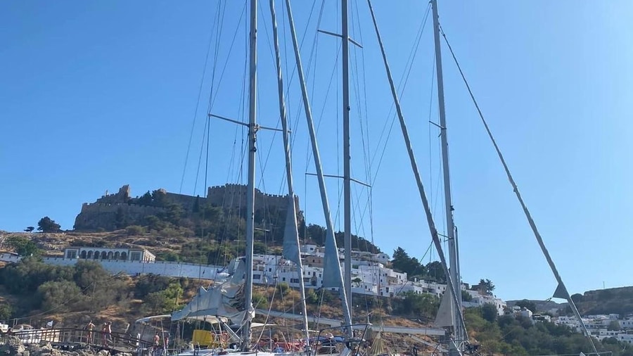
Megalos Gialos sits in the southern part of a closed bay about 2,000 m long. The beach faces north-east, and rocky outcrops close both ends. An iron pier stands on its northern part.
On a Rhodes yacht cruise, the water of Megalos Gialos looks shallow. The sea reaches 5 m deep about 155 m out. Marine life there is mainly algae, limpets and bivalve shells.
Mikros Gialos is the small beach in St Paul’s Bay, just south of the acropolis. It is a closed natural cove, 90 m long and 5 m wide on average. The cove faces north.
A Rhodes yacht cruise sees the Knights’ castle on the acropolis. It once had a large round tower on its east side, facing the sea. Below, the Byzantine Panagia church rises with its belltower.
Strabo knew the same site. He described Lindus as lying “on the side of a hill, looking towards the south and Alexandria”. The modern town stands on exactly that spot.
A Rhodes yacht cruise passes a town with deep roots. Homer’s Catalogue of Ships names Lindus among the cities at war with Troy. Lindus held two revered sanctuaries, of Athena and of Heracles.
- Shore: Tamarisk and pine trees grow along Mikros Gialos.
- Colony: In the 7th century BC, settlers from Tilos and Lindos founded Gela in Sicily.
- Land: The ground around ancient Lindus was rich in wine and figs.
In St Paul’s Bay, the sea reaches 5 m deep about 70 m out. Lindian boys sang a poem credited to Cleobulus while collecting money for the swallows’ return. A Rhodes yacht cruise reads Lindos in layers.
What winds shape a Rhodes yacht cruise?
A Rhodes yacht cruise feels its main wind from the west for nearly the whole year. Beaches on the west coast face that wind. Bays on the east coast stay sheltered. Old Mediterranean wind names still describe each direction.
HNMS, the Greek weather service, keeps wind tables for Rodos. The main wind blows from the west in eleven months. Only December turns north-west. For a Rhodes yacht cruise, September averages 9.6 knots.
The west coast takes it head-on. Kremasti beach, on the north-west coast, is exposed to the main winds, except north-westerlies. Theologos beach lies 22 km south-west of Rhodes town. Only south-westerlies spare it.
Kritika beach sits in Trianta bay, about 2 km south-west of Rhodes town. Enydreiou 1 beach in town is 900 m long and faces west. A Rhodes yacht cruise meets the main winds at both.
Kallithea beach, about 11 km from Rhodes town, is protected from the main winds. So is Zefyros beach, just south of the central harbour. A Rhodes yacht cruise finds sheltered bays on the east side.
Two east coast beaches have one open side. Kathara Faliraki, in Kallithea bay, is sheltered except from north-easterlies. Traounou, in the north of Afantou bay, is sheltered except from south-easterlies.
Medieval Mediterranean seafarers named eight winds. Tramontana blew from the north, Greco from the north-east and Levante from the east. Scirocco came from the south-east and Ostro from the south. Libeccio, Ponente and Maestro covered south-west, west and north-west.
- Ponente: This west wind, pounentes in Greek, takes its name from the Latin pono, to place.
- Libeccio: This south-west wind has the Greek local name garbis.
- Scirocco: Its name comes from the Arabic al-Sharq, meaning east.
Aristotle once counted ten distinct winds in his weather studies. On a Rhodes yacht cruise, the west wind still sets the plan. One coast takes it, and the other stays sheltered.
How do sailors find their way on a Rhodes yacht cruise?
A Rhodes yacht cruise finds its way with charts, sea marks and lighthouses. Each mark uses colour, shape and light to show safe water. Sailors read these signs by day and night. The craft has deep roots on Rhodes.
Timosthenes of Rhodes was a Greek navigator and geographer. In the 280s–270s BCE, he was admiral and chief pilot for King Ptolemy II Philadelphus of Egypt. His ten books of sailing directions are lost.
He is credited with the Greek 12-wind rose, a system of twelve winds. He was arguably the first Greek geographer to use winds to give direction, not only to describe weather.
On nautical charts, the top is always true north, not the magnetic north of a compass. Charts commonly add a compass rose that shows the gap. A Rhodes yacht cruise plots its route on them.
The vast majority of charts use the Mercator projection. A course drawn on it is steered directly. The first projection, from Marinus of Tyre around AD 100, suits small seas like the Aegean.
A Rhodes yacht cruise also reads cardinal marks, which are black and yellow with two cones on top. Cones up mean north, and down mean south. Cones pointing together mean west, and apart mean east. On a lit cardinal mark, the flashes follow a clock face. Three flashes mean east, nine mean west, and nonstop flashes mean north.
In IALA Region A, a Rhodes yacht cruise entering harbour keeps red port marks to its left. Green starboard marks stay to its right. Port marks are can-shaped and starboard marks conical.
- Isolated danger: Black with red bands, it marks a hazard like a partly submerged rock.
- Safe water: Red and white vertical stripes show open, deep, safe water ahead.
- One system: A 1980 IALA conference merged 30 buoyage systems into one.
A French lighthouse company first built Prasonisi Lighthouse in 1890. It joined the Greek lighthouse network in 1947. Today, its 14 m tower holds a light 65 m above the sea.
How safe is a Rhodes yacht cruise?
A Rhodes yacht cruise is backed by the Hellenic Coast Guard and by long-tested sea rules. Set radio calls warn others of danger. Fixed steps shape a rescue after a fall overboard. Life jackets raise the chance of survival.
The Hellenic Coast Guard was set up by an Act of Parliament, Law No. 1753–1919. Its legal framework was reformed in 1927. It runs an emergency radio station, SXE, at Aspropyrgos.
The Coast Guard fleet holds about 240 to 250 vessels of all types, including eleven lifeboats. On a Rhodes yacht cruise, a distress call starts with mayday, said three times in a row.
Frederick Stanley Mockford, the radio chief at Croydon Airport, conceived the word from French in the early 1920s. In 1927, the International Radiotelegraph Convention adopted it for voice distress calls.
A false distress call is a crime in plenty of countries. Pan-pan, from the French for a breakdown, flags a lesser emergency. On a Rhodes yacht cruise, a mechanical failure or medical problem fits that call.
A person in the water is in grave and imminent danger, which meets the test for mayday. Whoever sees the fall shouts the word overboard. Every crew member within earshot repeats the call.
Constant pointing at the person helps the helmsman approach. On a Rhodes yacht cruise, a life jacket greatly improves the odds of survival. Before the engine starts, the crew checks for trailing ropes.
- Night lights: Certain modern lifebuoys carry seawater-activated lights for rescue at night.
- Materials: Plant-based kapok replaced cork in 1904, and synthetic foam took over in 1972.
- Mae West: Peter Markus invented this first inflatable life preserver in 1928.
Leonardo da Vinci once sketched a concept for a safety wheel. Centuries of trial turned such ideas into modern rings and jackets. A Rhodes yacht cruise carries that gear today.
What food and drink suit a Rhodes yacht cruise?
A Rhodes yacht cruise suits food that stays cold and safe in the heat. Cold dips, salads and seafood need a cool box on board. A local sweet from Rhodes can close the meal. Clear safety rules keep the table healthy.
Food safety rules name a danger zone. In this temperature range, food-borne bacteria grow easily. Agencies set it between 4 and 63 °C. On a Rhodes yacht cruise, food stays out of that range.
The Food Safety and Inspection Service adds a time limit. Food left in the danger zone for more than two hours is not safe to eat. A refrigerator has to stay below 40 °F, about 4 °C.
On a Rhodes yacht cruise, a cooler does the cold work. This insulated box, also called an ice chest, keeps food or drink cool. Reusable coolers have plastic shells with hard foam between them.
Disposable coolers are made only of polystyrene foam about 2 cm thick. Richard C. Laramy of Joliet, Illinois, filed for a United States patent on a portable ice chest. He filed on 24 February 1951.
Variants of the dip add garlic, spring onions or peppers, or use vinegar instead of lemon juice. Cold dips like this also suit a yacht cruise on Mykonos. As seafood, it needs the cool box.
- Protein foods: Meat, poultry, seafood, eggs and dairy are at risk.
- Cold sides: Cut fresh produce, cooked rice, pasta and salads share the risk.
- Rhodes sweet: Cyclamen bulbs become a spoon sweet with nutmeg, found nowhere else in Greece.
A Rhodes yacht cruise eats well when cold food stays cold. The cool box does the main work at sea. Plain dips and a local sweet keep the menu simple.
When is the best season for a Rhodes yacht cruise?
A Rhodes yacht cruise finds its best season from late spring to early autumn. The sea warms and the days grow long in late spring. Midsummer brings the hottest records at Lindos. September stays warm, with little rain on the coast.
In the last month of spring, the sea around Rhodes averages 20.1 °C. Daylight then lasts 14.0 hours a day. A Rhodes yacht cruise gets warm water and long days for swim stops.
The National Observatory of Athens runs a station at Lindos, 65 m above sea level. Late spring there brings a high of 26.9 °C and a low of 19.5 °C.
Early summer is almost dry. At Lindos, June brings an average low of 24.1 °C and 2.5 mm of rain. Rhodes Port records 6.3 mm in June. A Rhodes yacht cruise meets warm nights.
Midsummer brings the strongest heat. At Lindos, August nights hold an average low of 27.8 °C. Record highs there reach 42.7 °C in July and 43.1 °C in August.
The Rhodes Port station stands 4 m above sea level. It has recorded 36.4 °C in late spring. April there brings 19.2 mm of rain, so spring can still turn wet.
September keeps the warmth of summer. Rhodes Port has a September mean of 26.5 °C, and Lindos gets 6.1 mm of rain. A Rhodes yacht cruise then stays warm and dry.
- Autumn records: Port record highs reach 34.4 °C in September and 32.6 °C in October.
- Lindos in September: The average low is 24.8 °C, and the record high 39.8 °C.
- October mean: The port averages 23.4 °C.
The season for a Rhodes yacht cruise runs widest from late spring to early autumn. Midsummer suits travelers who like strong heat. The edges of summer bring milder days.
What do travelers ask about a Rhodes yacht cruise?
A Rhodes yacht cruise raises practical questions before boarding. Travelers ask about calm winter seas, cooking gas and drinking water on board. They also ask where the sea gets its water. Hot meals and food safety for vulnerable guests come up as well.
Is the sea ever calm in winter on a Rhodes yacht cruise?
Ovid and Hyginus wrote of the halcyon days, the seven days in winter when storms never occur. The Greek phrase first appears in The Birds by Aristophanes. At first they were fourteen days, seven on either side of the shortest day. Alcyone, as a kingfisher, nested on the beach. Her father Aeolus held back the winds.
How is cooking gas kept safe on a Rhodes yacht cruise?
Bottled cooking gas, called LPG, is heavier than air. Leaked gas flows along floors and settles in low spots. Makers add a strong-smelling odorant, ethanethiol, so leaks are easy to detect. Cylinders are filled to 80–85% of capacity, so the liquid has room to expand.
How much water do guests need on a Rhodes yacht cruise?
Workers in a hot climate can need up to 16 litres a day. In the United States, total daily water intake is set at 4.0 litres for adult men. Adult women get 3.0 litres. Thirst is a better signal than the old advice of 8 glasses a day.
Where does the sea of a Rhodes yacht cruise get its water?
The net inflow from the Atlantic Ocean into the Mediterranean is about 70,000 cubic metres a second. That inflow makes up a loss of about 1 m of sea level each year. The water in the deepest part of the Mediterranean stays at 13.2 °C.
Can food stay hot on a Rhodes yacht cruise?
Thermoelectric coolers plug into a car’s cigarette lighter socket. They use the Peltier effect with a fan to draw heat away. Reversing the current heats the contents instead. So one box can keep drinks cold or meals hot on deck.
Who takes extra care with food on a Rhodes yacht cruise?
Food-borne illness is more dangerous for certain groups. They are people with weakened immune systems, young children, the elderly and pregnant women. Symptoms can begin shortly after eating or as late as weeks afterwards. These guests gain from careful cold storage.