A Kos island tour drives around Kos in the Dodecanese, from the harbour town with its castle and ancient ruins to the mountain villages, the healing sanctuary of the Asklepieion and the bays of the south-west. This post covers what a Kos island tour includes, Kos town, the plane tree of Hippocrates, the Asklepieion, the ancient sites and the museum, Zia, Old Pyli, Antimachia castle, Kefalos, the south and north coasts, the hot springs, the history and the best season. It is one of the best tours in Greece on Greece VIP.
Each section ends with a Kos island tour that can be booked online.
What does a Kos island tour include?
A Kos island tour is a land route around Kos, the third largest island of the Dodecanese, by coach, jeep or private car, linking Kos town, the plane tree of Hippocrates, the Asklepieion, the castle at Antimachia and the villages of Pyli, Zia and Kefalos.
Kos belongs to the Dodecanese, the island chain of the south-eastern Aegean Sea. It lies off the coast of Asia Minor, and its Turkish name, İstanköy, grew out of the Greek words for “to Kos”. The island stretches 42.1 kilometres from end to end and 11.5 kilometres across, with a coastline of 112 kilometres, so every Kos island tour follows a long, narrow shape that runs from west to east.
Kos town is the principal town of the island, the seat of the municipality, the main port and the main population centre. The main villages are Kardamena, Kefalos, Tigaki, Antimachia, Mastihari, Marmari and Pyli, while Zia, Zipari, Platani, Lagoudi and Asfendiou are smaller. A Kos island tour links these places by road, so the route changes with the villages chosen. The 2021 census counted 37,089 residents on the whole island.
The land of Kos is the surviving part of an old mountain chain that broke up when earthquakes and subsidence in ancient times cut the island off. Quaternary layers on Kos hold fossil remains of horses, hippopotami and elephants, and a giant fossilised elephant molar went to the Paleontology Museum of the University of Athens. A Kos island tour therefore crosses ground with a long geological story as well as a human one.
Three kinds of land tour cover the island. A coach carries a group on a fixed route, a jeep suits a small party, and a private car lets the route follow the interest of the travellers. Sea trips are a separate subject: a Kos boat trip sails from the harbour to nearby islands, while this Kos island tour keeps to the roads of Kos.
- Rank: Kos is the third largest island of the Dodecanese, after Rhodes and Karpathos.
- Municipality: The present municipality dates from 2011, when Dikaios, Irakleides and Kos merged.
- Economy: Tourism is the main industry, and the beaches are the primary attraction.
Taken together, a Kos island tour covers a long, narrow Dodecanese island with a main town, a set of named villages and a record of settlement that reaches back to the Iliad. The sections below follow the stops in order. The first stop is Kos town, where the harbour castle, the ancient market and the streets of two later eras share one centre.


What does a Kos island tour see in Kos town?
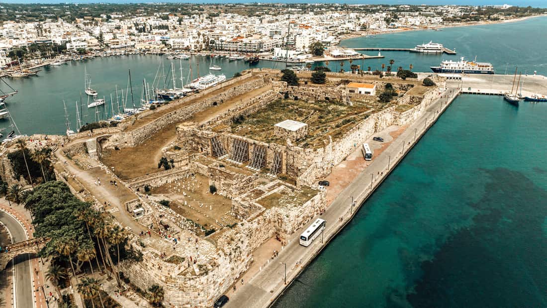
A Kos island tour sees the harbour town of Kos, the principal town of the island, with the Castle of the Knights at the harbour entrance, the ancient market place at its centre and Italian-period buildings beside older Ottoman ones.
Two eras shaped the town plan. The ancient city rose on a Hippodamian grid, and the modern one took form after the earthquake of 23 April 1933, which destroyed a great part of the old city. The architect Rodolfo Petracco drew the new plan, with residential, administrative and commercial areas, and turned the old quarters into an archaeological park. A Kos island tour therefore crosses both layers in one town.
The Italian period left more than a street plan, and a Kos island tour meets its work in the town centre. The synagogue Kahal Shalom stands on Alexandrou Diakou street in the historic centre and dates from 1935. Older buildings of the Ottoman centuries also remain. The Defterdar Mosque on Eleftherias Square, built in the 18th century, is a cubic two-storey building with an octagonal dome, and the Italians, who held the island, restored it after the earthquakes of 1926 and 1933.
The Castle of the Knights, also called Nerantzia, stands at the entrance to the harbour. The Knights Hospitaller raised it in 1315. During the conquest of Rhodes, the island passed to the Ottomans under the terms of the agreement, and the castle guards handed the fortress to the Ottoman captain Behram Bey and left. Word of the handover reached the Ottoman camp on 5 January 1523. The Greek Orthodox islanders stayed and received homes in the suburbs outside the castle.
The Ancient Agora stood at the heart of the ancient city and ranked among the biggest market places of the ancient world. A monumental entrance marked its northern end. In the first half of the 2nd century BC the building was extended toward the interior yard. A Kos island tour reads the agora as the oldest layer of the town centre, with the castle and the later buildings as younger layers.
- Synagogue: An older synagogue fell in the earthquake of 13 April 1933, and the Jewish community of Kos dates from antiquity.
- Mosque: The Defterdar Mosque takes its name from Ibrahim Efendi, an Ottoman minister of finance who ordered its construction.
- Agora: Shops stood on the eastern side of the ancient market place.
A Kos island tour in the harbour town therefore reads like layers laid one on another: the market of the ancient city, the Hospitaller fortress, the Ottoman mosque and the Italian-period streets built after the earthquake of 1933. The castle also marks the way to the next stop of a Kos island tour. The plane tree of Hippocrates grows on a square in front of the fortress, in the same town centre.
Why does a Kos island tour stop at the plane tree of Hippocrates?
A Kos island tour stops at the plane tree of Hippocrates because tradition says the physician born on Kos taught his pupils beneath it. The oriental plane stands on the Square of the Platane in Kos town centre, in front of the Castle of the Knights.
Hippocrates was born on Kos around 460 BC, a point on which historians agree. His father Heraclides was a physician, and his sons Thessalus and Draco and his son-in-law Polybus were his students. In Plato’s dialogue Protagoras he appears as “Hippocrates of Kos, the Asclepiad”. He travelled at least as far as Thessaly, Thrace and the Sea of Marmara, so a Kos island tour visits the home island of a physician who worked far beyond it.
The plane stands on the Platía Platanou, the Square of the Platane, in front of the Castle of the Knights and beside the Gazi Hassan Mosque in the centre of Kos town. Age has hollowed the trunk, and metal scaffolding now holds up the branches. Beside the tree runs a white tap with engravings in Arabic, built by the Turkish governor Gazi Hassan, so a Kos island tour sees the castle, the mosque and the tap together.
Tradition ties the tree to the lessons of Hippocrates. The tree standing today is only about 500 years old, and it is possibly a descendant of the original plane, which allegedly stood on the spot 2400 years ago, in the time of Hippocrates. Paul of Tarsus purportedly taught here as well. For that reason a Kos island tour presents the plane tree as a place of legend and memory, where the story is older than the tree.
Cuttings and seeds of the tree have spread across the world. A cutting from Kos was planted on 14 December 1961 on the grounds of the National Library of Medicine in the United States, and trees from the Kos plane grow at the Royal College of Physicians in London, the University of Barcelona and Kyushu University in Fukuoka City, Japan. A Kos island tour thus visits the source of a tradition that medical schools still honour.
- Species: The tree is an oriental plane, Platanus orientalis.
- Crown: The crown measures about 12 metres across and is said to be the largest of any plane tree in Europe.
- Mosque: The Gazi Hassan Mosque beside the square was erected in 1776.
- Foundation: The town also holds the International Hippocratic Foundation of Kos and the Hippocratic Museum dedicated to the physician.
A Kos island tour stops here because the square joins three layers of the town in one view: the story of Hippocrates, the Ottoman mosque and tap, and the Hospitaller castle behind them. The next stop leaves the square for the ruins of the Asklepieion, where Herodicus taught Hippocrates medicine.
Why does a Kos island tour visit the Asklepieion?
A Kos island tour visits the Asklepieion because the site was a healing temple to Asclepius and the place where Hippocrates is said to have trained. Its ruins show how ancient Greeks joined worship, rest, baths and early medicine in one sanctuary.
In Greek myth, Asclepius was the first doctor-demigod, and an asklepieion was the temple where patients sought his cure. Archaeologists have found more than 300 of them in the ancient Greek world, and the Kos sanctuary stood in the front rank beside Epidaurus, Athens, Corinth and Pergamon. Dorian settlers from Epidaurus brought their Asclepius cult to Kos, and the island became famous for its sanatoria. A Kos island tour that reaches the ruins steps into a famous healing site of antiquity.
Hippocrates of Kos, called the father of medicine, was born around 460 BC. He is thought to have trained at the Asklepieion, where the Thracian physician Herodicus of Selymbria taught him. Herodicus urged exercise, a careful diet and massage as treatments. That outlook matches a sanctuary where a priest sent patients to the baths or a gymnasium. This link brings a Kos island tour to the site.
Treatment began with purification: cleansing baths, a clean diet and an offering or a prayer. Patients then slept in a dormitory, hoping for a dream visit from Asclepius or from his daughters Hygeia and Panacea. On waking, the patient told the dream to a priest, who read it and set a cure. Dogs and harmless snakes moved through the halls, and the snake coiled round a staff, carried by Asclepius, is still used by medical bodies today. The ruins give a Kos island tour the setting for that routine.
The ruins were dug out in modern times. Rudolf Herzog, a German archaeologist and historian of medicine, led excavations of the Asklepieion from 1900 to 1907. The sanctuary itself grew in the 3rd and 2nd centuries BC, when the Asclepeion was built and enlarged. Ziaelas of Bithynia, Seleucus II Callinicus and Ptolemy III Euergetes backed its status as an asylum in 240 BC, which made the island more attractive to merchants and pilgrims. A Kos island tour sees the result of that growth in the ruins.
- Healing: Patients bathed, kept a clean diet and slept in the sanctuary to receive a dream cure.
- Teaching: Herodicus taught Hippocrates medicine at the site.
- Inscriptions: The Epigraphical Collection of the Asklepieion, at Platani, shows sacred laws and the honorary decrees of Koan doctors.
- Festival: The same collection lists the winners of the Great Asklepieia.
A Kos island tour treats the Asklepieion as the founding story of the island told in stone. The visit joins myth, temple practice and early medicine, and the inscriptions add the names, laws and contests that the ruins alone cannot supply. The next stops on a Kos island tour lie among the ancient and Roman remains of Kos town.
What does a Kos island tour see at the Ancient Agora, the Odeon and Casa Romana?
A Kos island tour sees the excavated heart of old Kos town at the Ancient Agora, the heavily restored Odeon and Casa Romana, a restored Roman house with three atria. Together the three stops show where the ancient city traded, listened to music and lived.
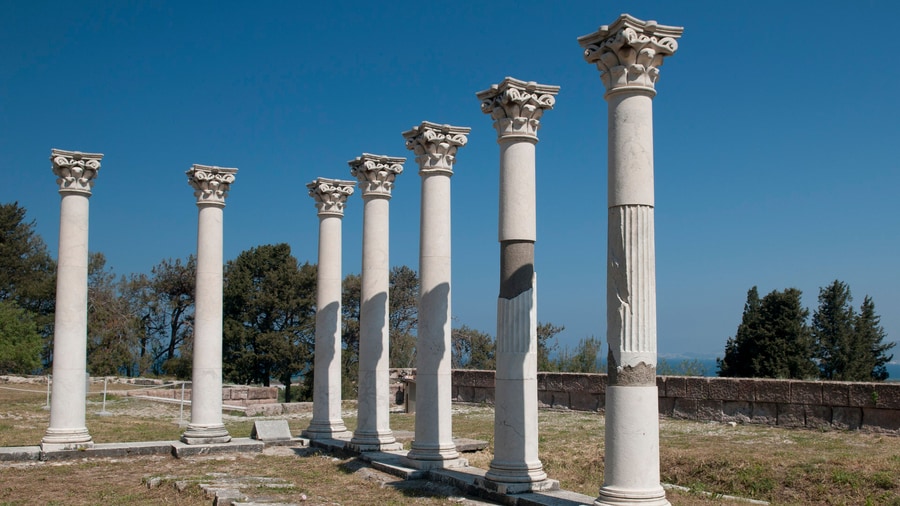
The ancient agora of Kos was the commercial and commanding centre of the old city, and it ranks among the biggest market places of the ancient world. The market was laid out around a rectangular yard that measured 300 metres in length and 50 metres in width, and it ended at the central road, the Decumanus. A monumental entrance stood on the north side, and shops lined the east side. A Kos island tour reads this plan from the excavated ground.
In the first half of the 2nd century BC, builders extended the market toward its inner yard. At the south end stood a round building with a Roman dome, next to a workshop that made pigments, Egyptian Blue among them. Rooms on the west side kept mosaic floors with beast fights, a theme popular in Kos. An earthquake in 469 AD destroyed the building.
The word odeon comes from the Greek for a singing place. It was a building for music, singing and poetry contests, and it looked like a theatre but was smaller and carried a roof for better sound. The Odeon of Kos is an ancient example, heavily restored, and the museum in the town holds finds from it. A Kos island tour that stops here sees how Kos set aside a building for music.
Casa Romana is a restored Roman house with three atria and spacious rooms that still keep frescoes, mosaics and marble floors. Its rooms display pottery, coins, glassware and sculptures. On 23 April 1933 an earthquake destroyed a large part of the old city, and the architect Rodolfo Petracco then drew up a new city plan and made an archaeological park of the old quarters. Italian archaeologists searched the islands for Roman antiquities from that decade onward. A Kos island tour therefore sees ruins shaped by the 1930s.
- Agora: A long rectangular market yard with shops along the east side and a monumental entrance in the north.
- Round building: A Roman dome stood at the south end beside a pigment workshop.
- Odeon: An ancient music hall, heavily restored.
- Casa Romana: A restored house with three atria, frescoes, mosaics and marble floors.
A Kos island tour reads Kos town as a layered city at these three stops. The agora shows trade, the Odeon shows music, and Casa Romana shows home life. The archaeological park around them records how the old quarters were reshaped after 1933. Together the three let a Kos island tour show how Greek and Roman Kos traded, listened and lived.
What does a Kos island tour show at the Archaeological Museum?
A Kos island tour shows an Italian-period building at the Archaeological Museum, an atrium holding sculpture from a Roman villa, and finds from the sanctuaries, the Agora and the Odeon. The displays follow the island from prehistory to Hellenistic times.
The Archaeological Museum of Kos sits in a building put up during the Italian occupation, and the building has since been declared a protected monument. The Italian architect Rodolfo Petracco designed both this museum and the market of Kos. Italy took the Dodecanese in 1912, and from the 1930s its archaeologists worked to find Roman antiquities, so the museum belongs to that period of digging and display. A Kos island tour that enters the building sees a landmark as well as a collection.
The atrium holds the sculptural decoration of the Roman villa known as the House of the Abduction of Europa. Two Roman houses of Kos therefore appear on the route: the restored Casa Romana, which keeps its rooms, and the House of the Abduction of Europa, whose sculpture is shown in this atrium. The pairing lets a Kos island tour compare a house still standing with the statuary of a house known through its finds.
The exhibition tells the history of the island from prehistoric to Hellenistic times. Its finds come from the sanctuaries of Kos, from the Agora, from the Altar of Dionysus, from the Odeon and from the Roman villa. A Kos island tour that has already seen the agora and the Odeon on the ground can match the finds to their places here. The Hellenistic period covered by the rooms is the age when Kos reached the height of its prosperity.
- Collection: Finds range from prehistoric to Hellenistic times.
- Sites: Objects come from the sanctuaries, the Agora, the Altar of Dionysus and the Odeon.
- Atrium: Sculpture from the House of the Abduction of Europa stands in the courtyard.
- Mosaic: A mosaic of the 3rd century shows Asclepius and Hippocrates.
One exhibit joins the two names that define the island. The mosaic shows Asclepius and Hippocrates, the god of medicine beside the physician of Kos. Asclepius was a man in Homer’s Iliad and a god by the day of Hippocrates, so the pairing in stone records that change. A Kos island tour closes the town’s run of ancient sites here, where the Asklepieion, the agora and Casa Romana return as objects and sculpture under one roof.
What does a Kos island tour see at Zia and Mount Dikaios?
A Kos island tour climbs to Zia, a village on the slopes of Mount Dikaios, the highest mountain on Kos at 846 metres. The stop gives wide views over the coast and the sea, framed by olive groves and pine, cypress and oak trees.
Mount Dikaios is the highest mountain of Kos, rising to 846 metres. In antiquity it went by the names Oromedon, Orion and Dikaion. Its summit point is called Psilo Vouno, a name that translates as the highest mountain. The massif is made of limestone and marble, with large masses of plutonic and volcanic rock. The mountain is easy to hike on one of the best-marked paths on the island. On a Kos island tour, the mountain stays in view as the route climbs towards Zia.
Zia ranks among the smaller villages of Kos, yet it sits on the slopes of the mountain in a wooded setting that a group notices at once. Water springs run down from the heights, and cobbled trails lead in between white and blue buildings. Cafes, traditional shops and tavernas fill the centre, and the alleys sell handcrafted items, local herbs, spices and traditional desserts, so a Kos island tour treats the village as a place to walk and browse.
The views are the main reward of the climb. From Zia, the outlook covers the coast of Kos and the nearby islands of Kalymnos and Pserimos, and the village is known for its sunsets. From the top of Mount Dikaios, a clear day shows Gyali, Nisyros and Pserimos, the settlement of Kardamena and the heart-shaped salt lake of Tigaki. A Kos island tour that reaches the heights therefore shows how the island sits among its neighbours.
- Chapel and cross: The summit holds a chapel dedicated to Christ and an imposing cross that looks tiny from below.
- Old remains: A small building near the chapel seems to have been a pilgrim cell, and a built cistern lies to the southwest.
- Watermills: A Kos island tour passes two traditional watermills, one on the way to Zia, and both are protected as historic monuments.
- Natural Park of Zia: The park sits in the pine forest, and a Kos island tour finds paths, animals and a playground there.
Locals celebrate the chapel on 6 August every year, and on the eve of the feast people hike up the mountain to honour it. Remains of a medieval settlement, water reservoirs and clay pots show intense human activity on the slopes in ancient and medieval times. Zia and Mount Dikaios give a Kos island tour its highest and greenest stop, where the air is clear and the walks lead through evergreen trees.
What does a Kos island tour find at Old Pyli and the mountain villages?
A Kos island tour finds the ruined Byzantine castle-town of Old Pyli on a 300-metre hill, the village of Pyli nearby, and Asfendiou, a protected settlement of stone houses on the slopes of Mount Dikaios, with its old churches and neighbourhoods.
On a Kos island tour, Old Pyli appears on a hill 300 metres high, three kilometres south-east of the present village of Pyli. The castle-town dates to the 11th century and occupies a natural fortified position under a strong acropolis. According to the life of Saint Christodoulos, the area was uninhabited when he arrived in 1080, and by 1088 it had become a settlement. The visible castle runs from the late 11th century to the mid 15th century and keeps seven towers from different periods.
The rectangular gate, framed by four semicircular arches, dates to the end of the 11th or the start of the 12th century. The earthquake of 1493 damaged the castle, and the Knights sent a committee to repair it the next year. Inside the castle-town, house ruins and cobbled streets surround the churches of Agios Antonios, Panagia Kastriani and Agioi Asomatoi. A Kos island tour that follows the forest path reaches a settlement abandoned in 1813 or 1830 after an epidemic decimated its population.
The present village of Pyli lies 15 kilometres south-west of Kos town, and in ancient times it was called Peli. Its square has stone-built houses and old-style cafes, and a nearby fountain sends cold water from six spouts. An inscription records the restoration of the fountain in 1592. A Kos island tour also finds the tomb of Harmylus, an ancient king of Kos, a Hellenistic burial complex of twelve graves under the chapel of Stavros, about 300 metres east of the central square.
- Location: A Kos island tour reaches Asfendiou, 14 kilometres south-west of Kos town on the slopes of Mount Dikaios.
- Neighbourhoods: Evangelistria, also called Pera Geitonia, and Asomatos keep a historic neo-Greek character.
- Churches: The church of Asomatos dates back to the 11th century, and the domed church of Panagia Evangelistria celebrates its feast on 8 September.
- Protection: The Ministry of Culture declared Asfendiou a protected settlement in 1983, and ruins of an early Christian basilica survive nearby.
Asfendiou flourished between 1850 and 1940, and the census of 1951 counted 2,800 residents, one of the largest figures in the Dodecanese. Residents then left for Germany, Australia, Canada and the USA, and only 100 live there today, working in viticulture and olive oil production. A Kos island tour that adds Old Pyli and Asfendiou sets the abandoned medieval castle-town beside the village that flourished after it.
Why does a Kos island tour stop at Antimachia castle?
A Kos island tour stops at Antimachia castle to see the fortress of the Knights Hospitaller, with its walls, two churches and the memory of the siege of 1457. The stop also takes in the village of Antimachia, its windmill and the island’s airport nearby.
A Kos island tour sees the castle on the edge of a plateau 166 metres high, near the modern village of Antimachia. From there, it overlooks the strait between Kos and the island of Nisyros. The walls form a triangle with a peak to the east, and each side works as an independent line of fortification that follows the shape of the terrain. The castle covers 26,250 square metres within a wall circuit of 970 metres, and the north-west side and parts of the south side survive.
Three grand masters shaped the castle, Villeneuve, Aubusson and del Carretto, and Ottoman rulers followed from the 16th to the 19th century. A decision of 1383 made it a prison for Knights accused or convicted of misdemeanours. The earthquake of 1493 damaged it, and the Knights restored it, leaving the arms of Aubusson, the shield of the Order of St. John and the date 1494 inside the walls. A Kos island tour reads these marks as a record of the island’s medieval rulers.
In June 1457, an Ottoman fleet attacked Kos, and the siege of Antimachia castle lasted 23 days. The castle sheltered people from the wider area, including those of Pyli and Kefalos. The attackers dug three great mines to open a gap in the defences, but the besieged countered them, and the Ottomans gave up on 26 June without taking the castle. The main attacks fell between 23 and 25 June. A Kos island tour tells this story at the walls themselves.
- Agios Nikolaos: The Byzantine church dates from the 16th century, and its courtyard holds a large cistern with a pointed vault.
- Agia Paraskevi: The second church seen on a Kos island tour dates from the early 18th century.
- Entrance bastion: A massive crescent-shaped bastion with deep ramparts guards the entrance, and the symbol of the Knights is engraved in marble.
- Old settlement: Ruins of the old village of Antimachia fill the interior, and the settlement was abandoned in 1840.
The village of Antimachia lies 4 kilometres from the castle, and its name goes back to an ancient town on Kos, the capital of the demoi of Aegelus and Archia. A folklore museum and a restored 19th-century windmill stand there, and a honey feast takes place towards the end of August. Kos International Airport opened near the village on 4 April 1964, so a Kos island tour pairs a medieval fortress with the island’s modern gateway.
What does a Kos island tour see at Kefalos and Agios Stefanos?
A Kos island tour sees Kefalos, a town on a peninsula at the south-west of Kos, and at Kamari Bay the Agios Stefanos basilica, an early Christian ruin, with Kastri, a volcanic islet holding the church of Agios Nikolaos, in the water.
A Kos island tour that heads for Kefalos reaches the western limit of the island. The town lies 43 kilometres from Kos Town and sits on a peninsula of the same name. A stone height carries the houses, and the windmill of Papavasilis stands over them. The 2021 census gave the town 2,329 inhabitants, and the wider local community 2,713.
Kefalos stands close to older capital ground. Astypalaea, at the west end of the island near the modern village of Kefalos, was the capital until 366 BC, when a new democracy moved the seat to the freshly built town of Cos on a Hippodamian grid. A Kos island tour therefore runs from the later capital at one end of the island to the earlier one at the other.
The attractions listed for Kefalos reach beyond the town centre. They include the cave at Aspri Petra, the monastery of Ayios Ioannis (Thimianos), the church of Isodia Tis Panagias, the ancient site of Palatia and Mikro Limanaki beach at the north of the peninsula. The area has taverns, bars, music and boat trips, but shops are limited, so a Kos island tour finds more than daily goods in Kardamaina or Kos Town.
Below the old town opens the Bay of Kamari, where the basilica of Agios Stefanos stands in ruins. Mosaic floors survive inside the remnants of its walls and columns. Sources call it a Roman Christian church and an early Christian basilica. In the water of the bay lies Kastri, a small volcanic island with the church of Agios Nikolaos. A Kos island tour sees the ruin and the islet within the same bay.
- Mount Zini: A rhyolite dome from the Quaternary Period closes the western end of the bay above the harbour.
- Ignimbrite cliffs: The sandy beach ends at volcanic cliffs marked by Greek quarrying for building stone.
- Harbour: Local fishing boats work the deep water and sell their catch to local restaurants.
- Nisyros: The volcanic island of Nisyros lies south of the bay.
Kefalos and Agios Stefanos mark the western end of a Kos island tour. The town offers a stone height with a windmill, the bay offers a ruined basilica with mosaic floors, and the water offers the islet of Kastri with its church. Together they show the early Christian past and the volcanic rock of the south-west corner of Kos.
Which south coast places does a Kos island tour pass?
A Kos island tour passes Kardamaina, a small town half-way along the south coast of Kos, and the beach stretches towards Kefalos, among them Paradise Beach and the sandy beach of Kamari Bay at the south-western end of the island.
Kardamaina, also spelled Kardamena, lies mid-way along the south coast of Kos. The town stands 7 kilometres from Kos Island International Airport at Antimacheia and belongs to the municipal unit of Irakleides in the Dodecanese. Its land area is 35.150 square kilometres, and the 2021 census counted 2,132 inhabitants. A Kos island tour on the south coast reaches the town that Kefalos names as its neighbour for shopping.
The town stands on the site of the ancient settlement of Alasarna. In the 2nd century BC, Alasarna was an important urban centre with a thousand citizens, not counting slaves. Excavations brought to light a temple of Apollo, an extensive early Christian settlement that ranks among the rare ones known in Greece, and four basilicas of the same period. Millstones, tools, vases and vessels, mainly of volcanic and sedimentary rock, were also recovered.
Kardamaina began as a small fishing village. It has drawn summer visitors since the 1960s, and the town now offers pubs, restaurants, bars, night clubs and watersports facilities. Between June and September the population triples with the arrival of tourists. Kardamena is a popular resort for young holidaymakers, primarily from the United Kingdom and Scandinavia, and a Kos island tour passes its large number of bars and nightclubs.
Beaches are the main attraction of the island, and tourism is its main industry. Cape Lacter, one of the promontories with a name from antiquity, lies in the south. At Kamari Bay a sandy beach separates the harbour from the cliffs of Mount Zini. Buses run from the bay to Kos Town by way of Paradise Beach, the airport, Antimachia, Mastichari and Zipari, so a Kos island tour on this road meets the beaches in that order.
- Bus link: A transit bus service runs between the airport and Kos town, Mastichari, Kardamena and Kefalos.
- Hellenistic builders: A temple to Apollo and fortification works rose at Alasarna in the 3rd and 2nd centuries BC.
- Nisyros trips: In summer, daily trips to Nisyros leave from the village of Kardamena.
The south coast gives a Kos island tour a change from the ruins of the capital and the villages of the hills. Kardamaina joins an ancient site, early Christian remains and a resort of the 1960s onwards, and the beaches of the coast carry the main industry of the island. A Kos island tour that reaches Kardamaina has therefore met the ancient, the Christian and the modern layers of the south coast in one town.
What are the hot springs at Therma on a Kos island tour?
A Kos island tour that stops at the hot springs of Therma reaches thermal water, which is groundwater heated by the earth. Kos stands on volcanic ground beside Nisyros, and geology explains how heat from magma or deep hot rock warms such springs.
A hot spring, also called a thermal, hydrothermal or geothermal spring, is a spring produced when geothermally heated groundwater emerges at the surface of the Earth. A thermal spring is one whose water sits 6 to 8 degrees Celsius or more above the mean air temperature. The heat itself is produced in the Earth’s mantle. A Kos island tour that visits Therma looks at an example of this process.
Two paths bring heat to the water. In areas of high volcanic activity, shallow bodies of magma heat the groundwater, which rises to the surface and emerges at a hot spring. Elsewhere, rock grows hotter with depth, so water that sinks deep along faults picks up heat from the hot rock. Part of Kos belongs to the same volcanic complex as Nisyros, so the volcanic path is part of the setting of a Kos island tour.
The neighbouring island of Nisyros shows how strong that heat can be. It is a volcanic island between Kos and Tilos, and fumaroles open at its craters while the volcano is active without erupting. Its geothermal field is an important high-enthalpy field in Greece, with a fluid temperature of over 350 degrees Celsius. The same volcanic complex stretches from the seafloor between Nisyros and Kos to Gyali and a part of Kos itself.
There is a wide variety of rocks on Kos, linked to the way the island formed. Hot springs also have a long link with the island. By the time of Hippocrates, around 460 BCE, hot springs were credited with healing power, and the ancient physician is thought to have been born on Kos. A Kos island tour therefore ties the thermal water to the medical fame of the island.
- Hot spring: A spring fed by groundwater that geothermal heat has warmed.
- Magma: In volcanic areas, shallow magma heats the groundwater.
- Faults: Water that circulates deep along faults is heated by hot rock.
- Greece: The country has 752 thermal springs, and a national institute has classed springs as therapeutic.
The hot springs at Therma add a thermal stop to a Kos island tour that is otherwise made of ruins, villages and beaches. The facts that hold across the Dodecanese are clear: heated groundwater, volcanic ground, an active volcano on Nisyros and a long Greek tradition of thermal water. A Kos island tour that visits Therma therefore joins the medical past of the island to its volcanic present.
Which north coast places does a Kos island tour pass?
A Kos island tour passes Tigaki, Marmari and Mastichari on the north coast, where sandy beaches, a former salt production site beside the Alykes lake and a harbour with boats to Kalymnos lie below the pine forests and farmland of the gentler northern slopes.
The island is 42.1 kilometres long and 11.5 kilometres wide, with a shoreline of 112 kilometres in length. The southern slopes are steep and rocky, while the northern slopes are gentler and descend to pine forests and farmland. That contrast shapes every Kos island tour: the road through the hills gives way to a softer shore where the villages face the sea. Tigaki, Marmari and Mastichari all stand on this northern side of the island.
Roughly 10 kilometres separate Tigaki from Kos Town, and the main road to Kefalos passes about 1.5 kilometres from the village. Bus routes link the village with Kos and Kefalos, so a Kos island tour by coach reaches it along the main road. The settlement grew from a farming village and fishing port into a holiday resort, and Tigaki Beach and Lambi Beach are both sandy.
The Alykes salt lake lies about 400 metres from the centre of Tigaki. A vehicle can drive to it, and structures from the former salt production site still stand there. A description of the 1943 fighting also records large salt flats at Lambi and Tigaki, so the salt works were already part of this coast in the war years. A jeep or private car on a Kos island tour reaches the lake easily.
Marmari is listed among the main villages of Kos and lies south of Tigaki, close to Zipari and Linopotis. Mastichari lies west of Tigaki, with the island airport 7 kilometres away. Its port sends boats to Kalymnos, and the settlement dates only from 1933, when an earthquake in a nearby village forced its people to move. That earthquake returns later in the story of a Kos island tour.
- Tigaki: The village centre stands 150 metres from the sea and 400 metres from the Alykes lake.
- Alykes: Structures from the former salt production site are preserved beside the lake.
- Mastichari: The port sends boats to Kalymnos, and the airport lies 7 kilometres away.
The north coast gives a Kos island tour a seaside counterpart to the ruins of the town and the villages of the hills. Tigaki, Marmari and Mastichari show a coast that moved from farming and fishing to holiday resorts, while the Alykes lake keeps the record of an older salt industry. German troops also came ashore at Marmari and Tigaki in 1943.
What ancient history does a Kos island tour recall?
A Kos island tour recalls an ancient island that Dorians settled, that joined a six-city league, taught medicine in the Hippocratic school, wove silk, made wine and amphorae, saw Ptolemy II born and became a free city under Rome.
The 11th century BC brought Dorian invaders, who founded a colony. Late in the 6th century BC, the island came under Persian rule, and it rebelled after the Greek victory at Mycale in 479 BC. It later joined the Delian League, and in 366 BC a democracy took power and shifted the capital to a fresh site laid out on a grid, the town of Kos. A Kos island tour recalls these early centuries.
Hippocrates came from Kos, where he was born about 460 BC, the son of a physician named Heraclides. He is believed to have learned his craft at the Asklepieion of Kos and took lessons from Herodicus of Selymbria. The Hippocratic or Koan school stressed patient care and prognosis. A medical school existed on Kos in the Hellenistic age, but the theory that Hippocrates founded it is a leap beyond the record, so a Kos island tour treats the physician and the school separately.
Ptolemy II was born on Kos in 309 or 308 BC, while his father invaded the Aegean in the Fourth Diadoch War. Philitas of Cos, a Hellenistic poet and scholar, helped to educate him, and he later ruled the Ptolemaic Kingdom from 284 to 246 BC. Kos meanwhile grew into a provincial branch of the Museum of Alexandria and a favourite place to educate the princes of the dynasty. A Kos island tour recalls the peak of the island’s prosperity in this age.
Proximity to the east gave the island first access to imported silk thread, and Aristotle mentions silk weaving by its women. Modern research doubts the old idea of transparent dresses, because Coae vestes seems to name a type of silk garment, not a place of manufacture. Kos also produced oars and amphorae, and its wines were famous. Under Rome it became a free city in 53 AD, and a Koan physician served three emperors, so a Kos island tour reaches the Roman era through medicine as well.
- League: Kos belonged to the Doric Hexapolis with Lindos, Kamiros, Ialysos, Knidos and Halicarnassus.
- Judges: Other cities such as Samos, Naxos and Thasos asked Kos to send judges to settle disputes.
- Asylum: A decision of 240 BC turned the Asklepieion into an asylum that drew merchants and pilgrims.
The ancient story shows a Kos island tour what the island was before castles and earthquakes: a Dorian colony, a centre of medicine, a Ptolemaic seat of learning and a free Roman city. The next chapters turn from the old Aegean powers to the Knights, the Ottomans and the Italians who held Kos in later centuries.
What modern history does a Kos island tour recall?
A Kos island tour recalls Genoese and Hospitaller rule, the Ottoman centuries, Italian planning and rebuilding after the earthquake of 1933, the German victory in the Battle of Kos in 1943 and the transfer of the island to Greece in 1947.
After the 11th century, Kos came under Genoese control, and the Knights Hospitaller lived on the island as tenants of the Genoese republic. Under the Knights the island was called Lango, and The Travels of Sir John Mandeville treats Lango and Kos as two separate islands by mistake. Piero de Ponte was the last Hospitaller governor, and a Kos island tour meets that period in the fortress the Knights built at the harbour in 1315.
When Ottoman forces took Rhodes in 1522, the terms also covered Kos, and the castle guards handed the castle to Captain Behram Bey and left. The Greek Orthodox residents stayed and lived in the suburbs outside the castle. In the Orlov revolt, Russian ships arrived at Kos, and a landing party sent against the castle on 5 August 1773 lost heavily. The census of 1881 to 1893 also recorded 2,439 Muslims and 67 Jews beside the Greek majority.
Italy occupied Kos in 1912 after the Italo-Turkish War. An earthquake on 23 April 1933 then demolished 90 percent of the homes in the historic centre, and at least 181 people died. The new city plan came from the architect Rodolfo Petracco: the ruined old quarters became an archaeological park, and the rebuilt town was split into residential, administrative and commercial zones. A Kos island tour sees that plan in the open ruins beside the modern streets.
On 3 October 1943, German troops landed to take Kos from the British and Italian garrison. The main landings came ashore at Marmari and Tigaki on the north side, so a Kos island tour along that coast passes the landing places. Further landings hit Camare Bay in the south-west, and paratroops dropped near Antimachia. By 4 October, 1,388 British and 3,145 Italian soldiers were prisoners, and the Italian commander and 101 officers were executed.
- Synagogue: Kahal Shalom was built in 1935, and Armando Bernabiti and Rodolfo Petracco designed it.
- Deportation: Nearly 100 members of the Jewish community were deported on Sunday 23 July 1944, and the synagogue was abandoned.
- Union: Kos became a protectorate of the United Kingdom in 1945, and Greece received it in 1947.
The modern record of Kos is a chain of changing flags: Genoese, Hospitaller, Ottoman, Italian, German, British and finally Greek. A Kos island tour reads that chain in the harbour fortress, the planned town, the open archaeological park and the north side landing beaches. Each change left a building or ruin on the route, and the transfer to Greece in 1947 closed the series.
When is the best season for a Kos island tour?
A Kos island tour suits the hot, dry summer for clear skies and the cooler months for lighter crowds. Kos has a hot-summer Mediterranean climate, so the sun is steady in summer, a sea wind cools the coast in July and August, and the winter brings rain.
Kos has a hot-summer Mediterranean climate, the Csa type that the Hellenic National Meteorological Service lists as the main climate of Greece. The east of the Pindus range is drier and windier in summer than the west, and Kos lies on that eastern Aegean side. Nisyros, the island directly south of Kos, falls into the hot semi-arid group together with Kasos and Karpathos. A Kos island tour therefore runs through a landscape with a long dry season, and the choice of month decides how much sun, wind and rain each stop receives.
Summer is the dry season. In the Csa zone the weather is sunny and dry in the warm months, and rain falls only as showers or thunderstorms from cumuliform clouds. The air is hot in the day and warm at night. Heatwaves reach the coast in a milder form, because the cooler sea and the sea breeze moderate the temperature. A Kos island tour in July or August therefore meets full summer sun at every stop, with the sea breeze softening the heat near the coast and the farmland of the north.
The etesians, also called meltemia, are the summer wind of the Aegean. Their name comes from the Greek word for year, which marks their annual return. They blow from late spring to October and peak in frequency in July and August. Their effect is a cooler Aegean, with lower temperatures and a narrower gap between day and night than over the Ionian Sea or the Greek mainland. A Kos island tour in high summer therefore trades part of the heat for a steady breeze on the open coast.
Winter is the wet season. Winters in the Csa zone are wet, the rain is persistent, and any snow melts soon, especially on south-facing slopes. Winter averages in the Dodecanese locally reach over 15 degrees Celsius, so the cold stays mild. The rain falls on the pine forests and farmland of the gentler northern slopes, where grapes, almonds, figs, olives, tomatoes, wheat and corn grow. A winter Kos island tour meets wet days on the road, mild air and a countryside in its rainy months.
- Summer: Sunny, dry weather rules the warm months, and the etesian wind peaks in July and August.
- Winter: Wet weather brings persistent rain, and snow does not last long on the south-facing slopes.
- Wind: The etesians blow from late spring to October and keep Aegean temperatures lower than those over the Ionian Sea.
- Quieter months: Kos Airport peaks in summer with flights from German and British airlines, so the other months bring a lighter flow of holidaymakers.
A Kos island tour has no closed season, because the climate gives dry sun in summer and rain in winter. Summer suits travelers who want clear skies and accept the heat and the etesian wind. The cooler months suit travelers who want a quieter island, with winter rain as the cost. Kos town, the ancient sites and the villages all share the same hot-summer Mediterranean pattern, so the choice rests on weather and crowds alone.
What do travelers ask about a Kos island tour?
A Kos island tour raises questions about access, population, terrain and the link with Rhodes. Kos has an international airport, a main port, 37,089 residents at the 2021 census, a steep south coast and gentler northern slopes, and a neighbour in Rhodes, the largest Dodecanese island.
How do travelers reach the island for a Kos island tour by air and ferry?
Kos International Airport, named for Hippocrates, opened on 4 April 1964 and lies near Antimachia on the provincial road to Kefalos. Its runway grew to 2,400 metres in 1974, and the airport mainly serves charter flights. By sea, Kos town is the main port. After the earthquake of 21 July 2017 cracked the floor of the main harbour, officials rerouted all ferries to Kefalos in the west, which shows that a second port exists for a Kos island tour. Kos town sits at the east end of the island, and a road runs from it to Kefalos in the west.
What is the population of the island visited on a Kos island tour?
Kos had 37,089 residents at the 2021 census, which places it second to Rhodes in population among the Dodecanese islands. Kos town is the main population centre, and tourism is the main industry. A report on the island in 1943 counted 20,000 Greek civilian inhabitants, so the island has grown since then. A Kos island tour passes the main villages of Kardamena, Kefalos, Tigaki, Antimachia, Mastihari, Marmari and Pyli.
How does the land change across the island on a Kos island tour?
The island measures 42.1 by 11.5 kilometres, with a coastline of 112 kilometres. The south coast is steep, and hills run from Cape Foca in the east westwards past Pyli, falling in height towards the west end. The steep southern slopes are rocky. The northern slopes are less steep and descend to pine forests and farmland, with sandy beaches and large salt flats at Lambi and Tigaki. A Kos island tour therefore climbs on the south side and runs along gentler ground in the north.
Can a Kos island tour pair with a Rhodes boat trip on another island?
Yes, as two outings on two islands. Rhodes is the largest of the Dodecanese islands and their historical capital, and Kos is the third largest after Rhodes and Karpathos. Mandraki, the oldest port of Rhodes, sends cruise boats on daily trips to Symi or to the southern east coast as far as Lindos, so a Rhodes boat trip covers the sea while a Kos island tour covers the land. Ferries connect Rhodes daily with nearby Dodecanese islands.
Featured photo: Arne Müseler, CC BY-SA 3.0 DE, via Wikimedia Commons.